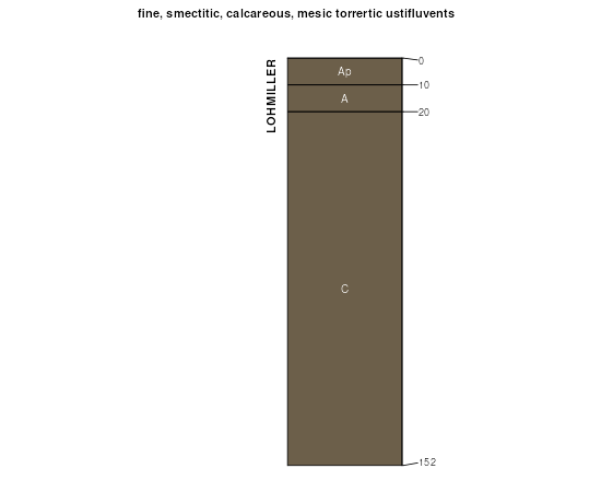
| Lohmiller silty clay | 37 | 4002 | 94998 | 35vg | co121 | 1982 | 1:24000 |
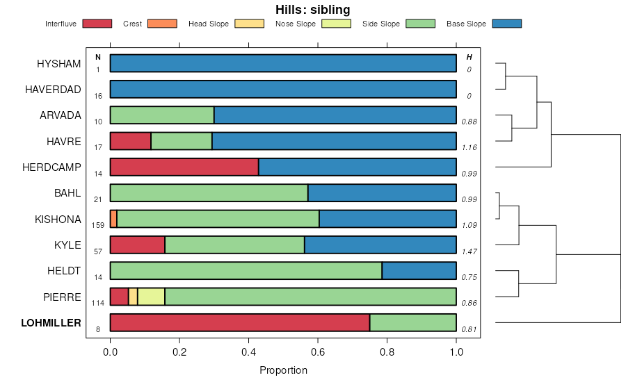
Havre and Lohmiller soils, saline | Hs | 6133 | 345450 | clgk | mt103 | 1961 | 1:20000 |
Havre and Lohmiller soils, 15 to 35 percent slopes | Hr | 3009 | 345449 | clgj | mt103 | 1961 | 1:20000 |
Lohmiller-Hysham clays | Lu | 1181 | 345471 | clh7 | mt103 | 1961 | 1:20000 |
Lohmiller clay | Lh | 949 | 345464 | clh0 | mt103 | 1961 | 1:20000 |
Lohmiller clay loam, fans, 0 to 1 percent slopes | Ls | 945 | 345469 | clh5 | mt103 | 1961 | 1:20000 |
Lohmiller-Hysham clay loams | Ly | 883 | 345472 | clh8 | mt103 | 1961 | 1:20000 |
Havre and Lohmiller soils, 8 to 15 percent slopes | Hp | 595 | 345448 | clgh | mt103 | 1961 | 1:20000 |
Lohmiller clay loam, high | Lt | 284 | 345470 | clh6 | mt103 | 1961 | 1:20000 |
Lohmiller clay loam | Lo | 200 | 345467 | clh3 | mt103 | 1961 | 1:20000 |
Lohmiller clay, wet | Ln | 145 | 345466 | clh2 | mt103 | 1961 | 1:20000 |
Lohmiller clay, high | Lm | 143 | 345465 | clh1 | mt103 | 1961 | 1:20000 |
Lohmiller clay loam, 1 to 3 percent slopes | Lr | 122 | 345468 | clh4 | mt103 | 1961 | 1:20000 |
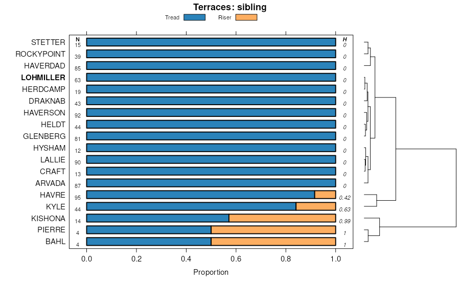
Lohmiller-Bainville complex, 4 to 15 percent slopes | Lt | 27806 | 345765 | 3219g | mt111 | 1966 | 1:20000 |
Lohmiller silty clay, 0 to 1 percent slopes | Lr | 18389 | 345763 | clsn | mt111 | 1966 | 1:20000 |
Haverson and Lohmiller soils, 0 to 4 percent slopes | Hl | 17050 | 345731 | clrm | mt111 | 1966 | 1:20000 |
Haverson and Lohmiller soils, channeled, 0 to 35 percent slopes | Hm | 10911 | 345732 | clrn | mt111 | 1966 | 1:20000 |
Lohmiller silty clay, 3 to 7 percent slopes | Lo | 7489 | 345762 | clsm | mt111 | 1966 | 1:20000 |
Lohmiller soils, seeped, 0 to 2 percent slopes | Ls | 4213 | 345764 | clsp | mt111 | 1966 | 1:20000 |
Lohmiller-Hysham silty clay loams, 0 to 1 percent slopes | Lu | 1667 | 345766 | clsr | mt111 | 1966 | 1:20000 |
Lohmiller silty clay, gravelly variant, 0 to 1 percent slopes | Lv | 1002 | 345767 | clss | mt111 | 1966 | 1:20000 |
Haverson and Lohmiller soils, channeled | HGb | 21426 | 345972 | cm0d | mt607 | 1970 | 1:24000 |
Lohmiller silty clay loam, 0 to 2 percent slopes | Lo | 6680 | 346051 | cm2y | mt607 | 1970 | 1:24000 |
Haverson and Lohmiller soils, frequently flooded | HGc | 5915 | 345973 | cm0f | mt607 | 1970 | 1:24000 |
Haverson and Lohmiller soils, wet | Hh | 3098 | 345989 | cm0y | mt607 | 1970 | 1:24000 |
Lohmiller-Midway silty clay loams, undulating | LV | 2215 | 346045 | cm2r | mt607 | 1970 | 1:24000 |
Hysham and Lohmiller silty clay loams, 0 to 8 percent slopes | HT | 1761 | 345976 | cm0j | mt607 | 1970 | 1:24000 |
Lohmiller silty clay loam, 4 to 8 percent slopes | Lr | 1681 | 346053 | cm30 | mt607 | 1970 | 1:24000 |
Lohmiller silty clay, saline, 0 to 2 percent slopes | Lt | 1348 | 346055 | cm32 | mt607 | 1970 | 1:24000 |
Lohmiller silty clay loam, 8 to 15 percent slopes | Ls | 1297 | 346054 | cm31 | mt607 | 1970 | 1:24000 |
Lohmiller silty clay loam, 2 to 4 percent slopes | Lp | 753 | 346052 | cm2z | mt607 | 1970 | 1:24000 |
Lohmiller silty clay, saline, 2 to 4 percent slopes | Lu | 110 | 346056 | cm33 | mt607 | 1970 | 1:24000 |
Lohmiller silty clay loam, frequently flooded | 5003 | 9752 | 358097 | d0mj | ne045 | 1973 | 1:20000 |
Lohmiller silty clay loam, channeled, 0 to 2 percent slopes, frequently flooded | 5005 | 4931 | 357939 | 2t34v | ne165 | 1993 | 1:20000 |
Lohmiller silty clay, occasionally flooded | 5006 | 1492 | 357941 | d0gh | ne165 | 1993 | 1:20000 |
Lohmiller silty clay loam, rarely flooded | 5004 | 814 | 357935 | d0g9 | ne165 | 1993 | 1:20000 |
Lohmiller silty clay loam, channeled, 0 to 2 percent slopes | Aa | 14782 | 352718 | cv10 | sd007 | 2004 | 1:20000 |
Lohmiller silty clay loam, 0 to 2 percent slopes | LnA | 9828 | 353195 | 30wnd | sd019 | 1970 | 1:24000 |
Lohmiller silty clay loam, acid variant | Ls | 1800 | 353198 | cvjh | sd019 | 1970 | 1:24000 |
Lohmiller silty clay loam, 2 to 6 percent slopes | LnB | 1202 | 353196 | cvjf | sd019 | 1970 | 1:24000 |
Lohmiller silty clay loam | Lo | 20902 | 355117 | 2y6f6 | sd047 | 1980 | 1:24000 |
Lohmiller silty clay loam, 0 to 2 percent slopes, rarely flooded | P213A | 197 | 2768102 | 2s03w | sd047 | 1980 | 1:24000 |
Lohmiller silty clay loam, channeled, 0 to 2 percent slopes, frequently flooded | Lp | 102 | 1398304 | 2t34v | sd047 | 1980 | 1:24000 |
Lohmiller silty clay, channeled | Lp | 9751 | 354112 | cwgz | sd055 | 1992 | 1:24000 |
Lohmiller-Arvada complex | Lv | 4697 | 354113 | cwh0 | sd055 | 1992 | 1:24000 |
Lohmiller silty clay | Lo | 691 | 354111 | cwgy | sd055 | 1992 | 1:24000 |
Lohmiller silty clay loam, 0 to 2 percent slopes, occasionally flooded | 618A | 125 | 1900519 | 21sn2 | sd081 | 2007 | 1:24000 |
Lohmiller silty clay loam, channeled | Lo | 9553 | 355859 | cy9b | sd137 | 1985 | 1:24000 |
Lohmiller silty clay loam | Ln | 4131 | 355858 | cy99 | sd137 | 1985 | 1:24000 |
Lohmiller and Glenberg soils, channeled | Lh | 39178 | 354327 | 2tvvv | sd600 | 1974 | 1:24000 |
Lohmiller silty clay loam | Le | 17471 | 354326 | cwpw | sd600 | 1974 | 1:24000 |
Lohmiller silty clay loam, channeled | Lg | 10749 | 355452 | cxw6 | sd601 | 1983 | 1:24000 |
Lohmiller silty clay loam | Ld | 6334 | 355451 | cxw5 | sd601 | 1983 | 1:24000 |
Lohmiller silty clay, channeled, 0 to 3 percent slopes, occasionally flooded | Lp | 31551 | 2580925 | 2t34y | sd606 | 2011 | 1:24000 |
Lohmiller silty clay | Lo | 15759 | 2580924 | cyhw | sd606 | 2011 | 1:24000 |
Lohmiller silty clay loam, channeled, 0 to 2 percent slopes | Aa | 30567 | 2925525 | cv51 | sd610 | 1965 | 1:20000 |
Lohmiller silty clay | Lo | 2234 | 2582637 | cy33 | sd611 | 2011 | 1:24000 |
Lohmiller silty clay, 0 to 3 percent slopes, occasionally flooded | N500A | 188 | 2485391 | 2pf7x | sd612 | 2011 | 1:20000 |
Lohmiller silty clay loam, channeled, 0 to 2 percent slopes | Aa | 42308 | 2582679 | cv2q | sd613 | 2011 | 1:24000 |
Lohmiller silty clay loam, occasionally flooded, 0 to 3 percent slopes | 102 | 9445 | 349179 | cqbv | wy011 | 1978 | 1:24000 |
Lohmiller silty clay loam, 0 to 3 percent slopes | 101 | 6362 | 349178 | cqbt | wy011 | 1978 | 1:24000 |
Lohmiller silty clay loam, cool, 0 to 3 percent slopes, rarely flooded | P216A | 1593 | 2745758 | 2rxs2 | wy011 | 1978 | 1:24000 |
Lohmiller silty clay loam, cool, 0 to 3 percent slopes, occasionally flooded | P214A | 23 | 2745759 | 2rxs3 | wy011 | 1978 | 1:24000 |
Lohmiller silty clay, 0 to 3 percent slopes | 158 | 3515 | 349630 | cqtd | wy027 | 1993 | 1:24000 |
Lohmiller-Haverdad complex, saline, 1 to 4 percent slopes | 159 | 465 | 349632 | cqtg | wy027 | 1993 | 1:24000 |
Lohmiller-Haverdad complex, saline, 1 to 4 percent slopes | 60 | 20131 | 349466 | cqn3 | wy045 | 1984 | 1:24000 |
Lohmiller-Haverdad complex, 1 to 4 percent slopes | 59 | 7792 | 349464 | cqn1 | wy045 | 1984 | 1:24000 |
Lohmiller clay loam, occasionally flooded, 0 to 3 percent slopes | 58 | 1957 | 349463 | cqn0 | wy045 | 1984 | 1:24000 |
Lohmiller-Rockypoint complex, 1 to 4 percent slopes, rarely flooded | P218B | 64 | 2745990 | 2rvdh | wy045 | 1984 | 1:24000 |
Haverdad-Lohmiller complex, 0 to 6 percent slopes, rarely flooded | 168 | 830 | 1669692 | 2wlrw | wy609 | 2006 | 1:24000 |
Lohmiller silty clay loam | Ls | 1062 | 350885 | cs3w | wy619 | 1971 | 1:24000 |
Haverdad-Lohmiller complex, 0 to 6 percent slopes, rarely flooded | 330 | 7 | 1426088 | 2wlrw | wy625 | 1985 | 1:24000 |
Haverdad-Lohmiller complex, 0 to 6 percent slopes, rarely flooded | 120 | 20662 | 351498 | 2wlrw | wy709 | 1983 | 1:24000 |
Lohmiller-Haverdad complex, 1 to 4 percent slopes | 240 | 101 | 1427897 | 1jxv6 | wy709 | 1983 | 1:24000 |
