| Litz silt loam, rolling | Lm | 1000 | 329183 | c1jt | al049 | 1953 | 1:20000 |
Litz silt loam, steep | Ln | 1000 | 329184 | c1jv | al049 | 1953 | 1:20000 |
Litz shaly silty clay loam, eroded, hilly | Lg | 1000 | 329179 | c1jp | al049 | 1953 | 1:20000 |
Litz silt loam, hilly | Ll | 1000 | 329182 | c1js | al049 | 1953 | 1:20000 |
Litz shaly silty clay loam, eroded, rolling | Lh | 500 | 329180 | c1jq | al049 | 1953 | 1:20000 |
Litz shaly silty clay loam, eroded, steep | Lk | 500 | 329181 | c1jr | al049 | 1953 | 1:20000 |
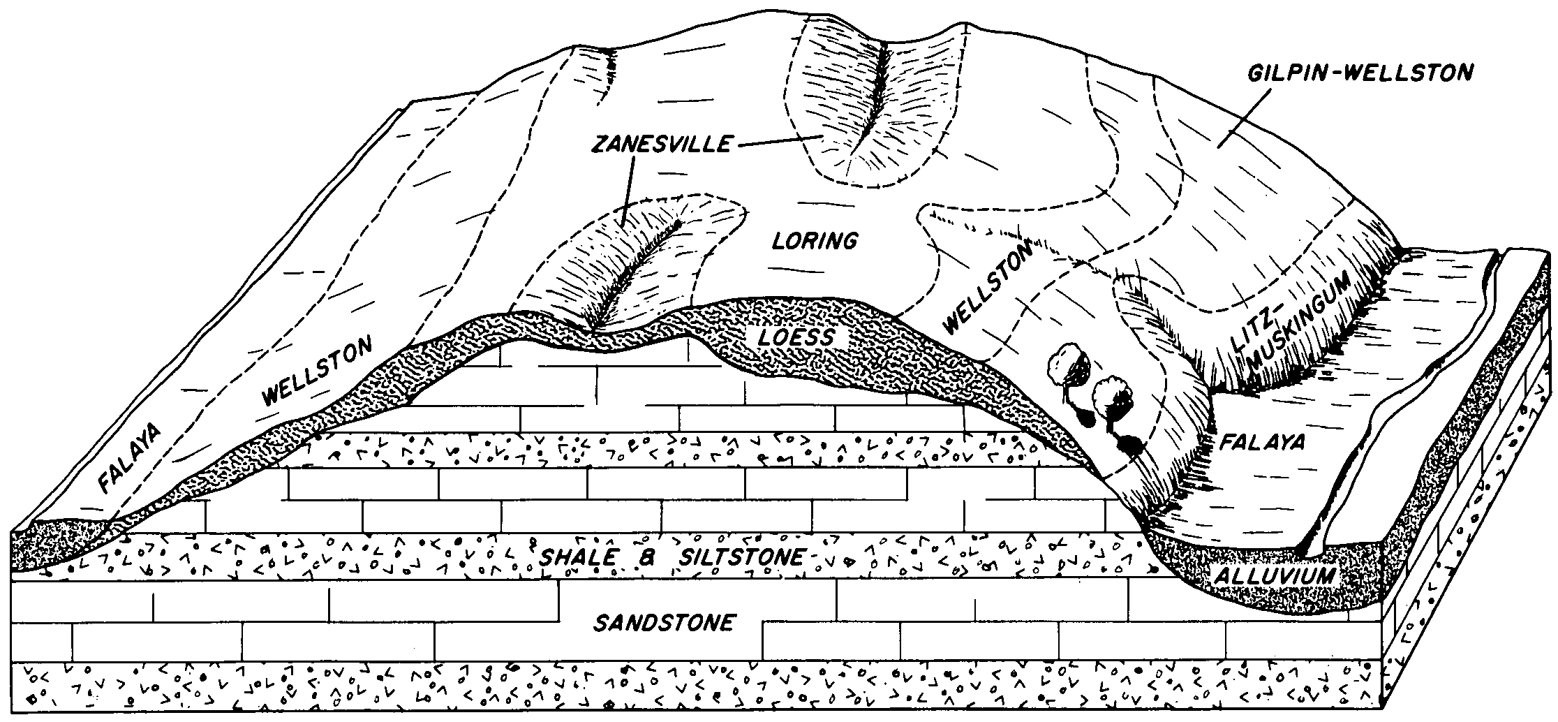
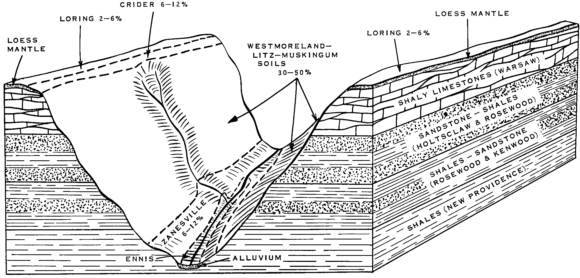
Litz-Muskingum silt loams, 30 to 50 percent slopes | LmF | 184 | 549194 | lfgy | ky101 | 1964 | 1:15840 |
Litz channery silt loam, 25 to 45 percent slopes | LtE | 2284 | 2401206 | 2lln8 | md001 | 2009 | 1:12000 |
Litz channery silt loam, 15 to 25 percent slopes | LtD | 1280 | 2401205 | 2lln7 | md001 | 2009 | 1:12000 |
Litz channery silt loam, 8 to 15 percent slopes | LtC | 461 | 2401204 | 2lln6 | md001 | 2009 | 1:12000 |
Litz channery silt loam, 3 to 8 percent slopes | LtB | 81 | 2401203 | 2lln5 | md001 | 2009 | 1:12000 |
Litz silt loam, 3 to 12 percent slopes, moderately eroded | LpB2 | 1975 | 539522 | l3dy | pa037 | 1965 | 1:20000 |
Litz and Weikert shaly silt loams, 20 to 35 percent slopes, severely eroded | LrD3 | 727 | 539525 | l3f1 | pa037 | 1965 | 1:20000 |
Litz and Weikert shaly silt loams, 35 to 50 percent slopes, moderately eroded | LrE2 | 595 | 539526 | l3f2 | pa037 | 1965 | 1:20000 |
Litz silt loam, 12 to 20 percent slopes, moderately eroded | LpC2 | 543 | 539523 | l3dz | pa037 | 1965 | 1:20000 |
Litz and Weikert shaly silt loams, 12 to 20 percent slopes, severely eroded | LrC3 | 290 | 539524 | l3f0 | pa037 | 1965 | 1:20000 |
Litz shaly silt loam, eroded rolling phase | Ln | 2128 | 526937 | kp9z | tn011 | 1951 | 1:20000 |
Litz shaly silt loam, eroded hilly phase | Lm | 1236 | 526936 | kp9y | tn011 | 1951 | 1:20000 |
Litz shaly silt loam, hilly phase | Lp | 637 | 526939 | kpb1 | tn011 | 1951 | 1:20000 |
Litz shaly silt loam, eroded undulating phase | Lo | 277 | 526938 | kpb0 | tn011 | 1951 | 1:20000 |
Litz shaly silt loam, rolling phase | Lr | 240 | 526940 | kpb2 | tn011 | 1951 | 1:20000 |
Litz loam, steep phase | Lk | 2153 | 525165 | kmgt | tn059 | 1954 | 1:15840 |
Litz loam, eroded steep phase | Lf | 1605 | 525162 | kmgq | tn059 | 1954 | 1:15840 |
Litz loam, hilly phase | Lg | 582 | 525163 | kmgr | tn059 | 1954 | 1:15840 |
Litz loam, eroded hilly phase | Ld | 410 | 525160 | kmgn | tn059 | 1954 | 1:15840 |
Litz loam, eroded rolling phase | Le | 342 | 525161 | kmgp | tn059 | 1954 | 1:15840 |
Litz loam, rolling phase | Lh | 308 | 525164 | kmgs | tn059 | 1954 | 1:15840 |
Litz shaly silt loam, steep, 25 to 55 percent slope | 79E | 5003 | 525351 | kmnt | tn063 | 2007 | 1:24000 |
Litz shaly silt loam, hilly, 12 to 25 percent slope | 79D | 2205 | 525349 | kmnr | tn063 | 2007 | 1:24000 |
Litz shaly silt loam, rolling, 5 to 12 percent slopes (sil) | 79C | 597 | 525348 | kmnq | tn063 | 2007 | 1:24000 |
Litz shaly silty clay loam, severely eroded, hilly, 12 to 25 percent slope | 79D3 | 318 | 525350 | kmns | tn063 | 2007 | 1:24000 |
Litz shaly silty clay loam, severely eroded, steep, 25 to 60 percent slope | 79E3 | 180 | 525352 | kmnv | tn063 | 2007 | 1:24000 |
Gullied land, Litz soil material | 105 | 174 | 525281 | kmlk | tn063 | 2007 | 1:24000 |
Litz silt loam, sloping phase | LtC | 953 | 525978 | knb1 | tn105 | 1958 | 1:15840 |
Litz shaly silty clay loam, sloping phase (sil) | LsC | 891 | 525975 | kn9y | tn105 | 1958 | 1:15840 |
Litz shaly silty clay loam, moderately steep phase (sil) | LsD | 828 | 525976 | kn9z | tn105 | 1958 | 1:15840 |
Litz silt loam, moderately steep phase | LtD | 531 | 525979 | knb2 | tn105 | 1958 | 1:15840 |
Litz silt loam, steep phase | LtE | 295 | 525980 | knb3 | tn105 | 1958 | 1:15840 |
Litz shaly silty clay loam, steep phase (sil) | LsE | 232 | 525977 | knb0 | tn105 | 1958 | 1:15840 |
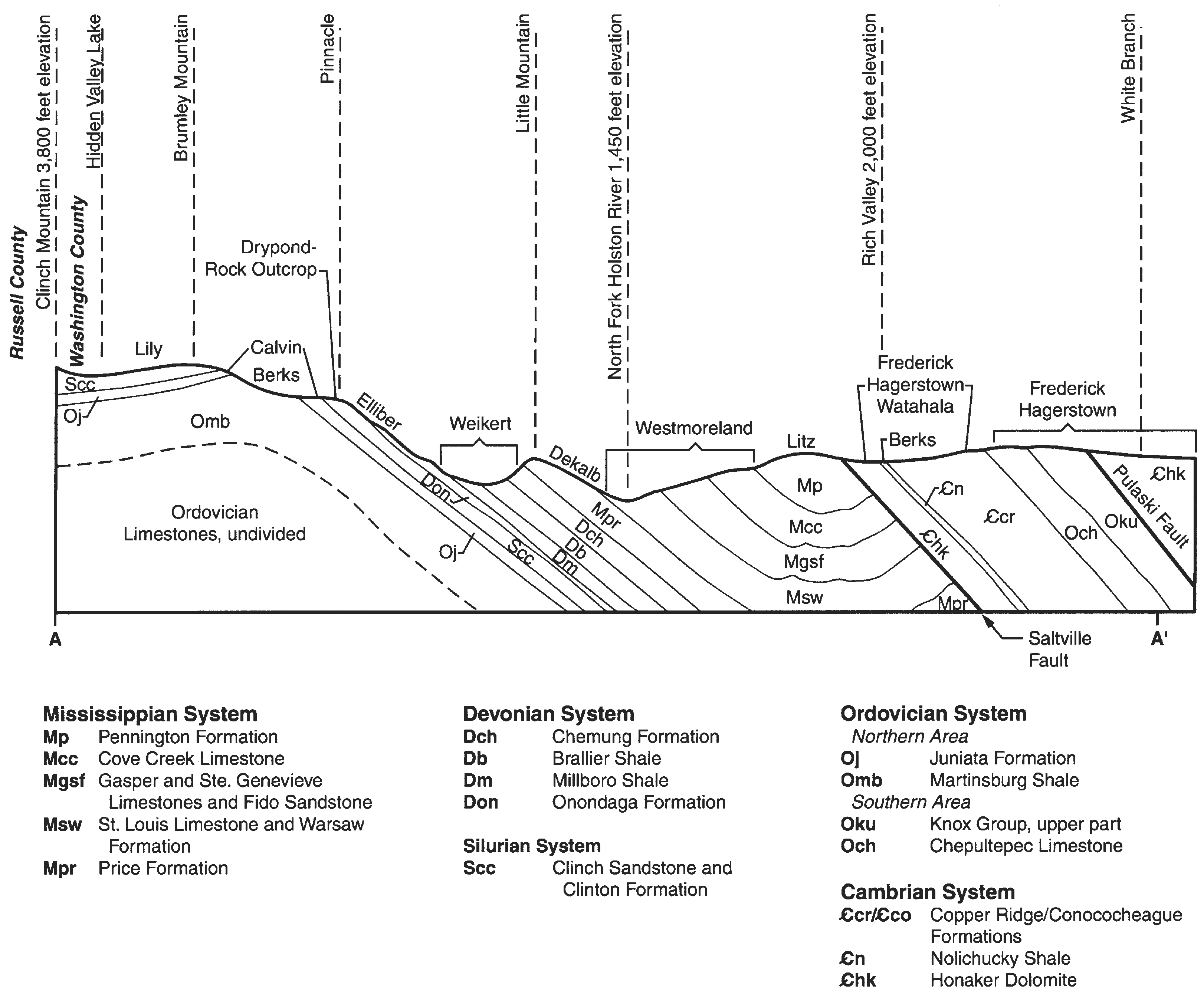
Litz shaly silt loam, 5 to 12 percent slopes (sil) | LtC | 3829 | 527909 | kqbb | tn123 | 1974 | 1:20000 |
Litz shaly silt loam, 20 to 35 percent slopes (sil) | LtE | 3410 | 527912 | kqbf | tn123 | 1974 | 1:20000 |
Litz shaly silt loam, 12 to 20 percent slopes, severely eroded (sil) | LtD3 | 2261 | 527911 | kqbd | tn123 | 1974 | 1:20000 |
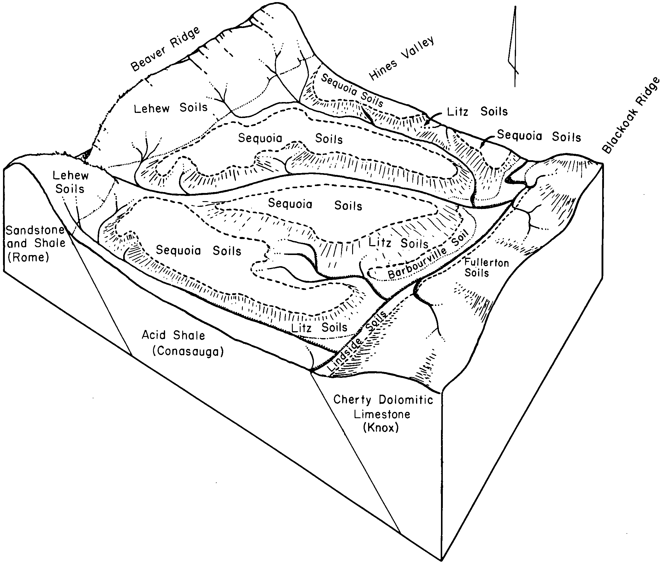
Litz and Sequoia soils, gullied | LY | 1375 | 527913 | kqbg | tn123 | 1974 | 1:20000 |
Litz shaly silt loam, 12 to 20 percent slopes (sil) | LtD | 1368 | 527910 | kqbc | tn123 | 1974 | 1:20000 |
Litz shaly silt loam, 35 to 60 percent slopes (sil) | LzF | 7129 | 528588 | kr17 | tn602 | 1973 | 1:15840 |
Litz shaly silt loam, 20 to 35 percent slopes (sil) | LzE | 2947 | 528586 | kr15 | tn602 | 1973 | 1:15840 |
Litz shaly silt loam, 20 to 35 percent slopes, severely eroded (sil) | LzE3 | 1604 | 528587 | kr16 | tn602 | 1973 | 1:15840 |
Litz shaly silt loam, 8 to 20 percent slopes (sil) | LzD | 1415 | 528585 | kr14 | tn602 | 1973 | 1:15840 |
Litz silt loam, sloping phase | Lk | 3197 | 1899530 | 21rm5 | tn609 | 1955 | 1:20000 |
Litz silt loam, moderately steep phase | Ll | 2233 | 1899531 | 21rm6 | tn609 | 1955 | 1:20000 |
Litz silt loam, gently sloping phase | Lh | 352 | 1899529 | 21rm4 | tn609 | 1955 | 1:20000 |
Chiswell-Litz complex, 25 to 50 percent slopes | 5E | 8779 | 520369 | kgh3 | va161 | 1990 | 1:24000 |
Chiswell-Litz-Urban land complex, 2 to 15 percent slopes | 6C | 5106 | 520385 | kghm | va161 | 1990 | 1:24000 |
Chiswell-Litz complex, 15 to 25 percent slopes | 5D | 3573 | 520368 | kgh2 | va161 | 1990 | 1:24000 |
Chiswell-Litz-Urban land complex, 15 to 35 percent slopes | 6D | 2891 | 520386 | kghn | va161 | 1990 | 1:24000 |
Chiswell-Litz complex, 7 to 15 percent slopes | 5C | 1703 | 520367 | kgh1 | va161 | 1990 | 1:24000 |
Groseclose-Litz complex, 25 to 35 percent slopes | 25E | 948 | 520257 | kgch | va161 | 1990 | 1:24000 |
Groseclose-Litz complex, 2 to 15 percent slopes | 25C | 728 | 520255 | kgcf | va161 | 1990 | 1:24000 |
Groseclose-Litz complex, 15 to 25 percent slopes | 25D | 676 | 520256 | kgcg | va161 | 1990 | 1:24000 |
Litz-Needmore complex, 35 to 70 percent slopes, very stony | 34F | 5258 | 2514811 | 2qdbm | va163 | 2010 | 1:24000 |
Litz-Needmore complex, 15 to 35 percent slopes, very stony | 34E | 2891 | 2514810 | 2qdbl | va163 | 2010 | 1:24000 |
Litz-Chiswell-Groseclose complex, 35 to 55 percent slopes | 33F | 2551 | 2514808 | 2qdbq | va163 | 2010 | 1:24000 |
Litz-Chiswell-Groseclose complex, 15 to 35 percent slopes | 33E | 2019 | 2514807 | 2qdbp | va163 | 2010 | 1:24000 |
Litz-Chiswell-Groseclose complex, 8 to 15 percent slopes | 33C | 653 | 2514806 | 2qdbn | va163 | 2010 | 1:24000 |
Litz-Needmore complex, 3 to 15 percent slopes, very stony | 34C | 37 | 2514809 | 2qdbk | va163 | 2010 | 1:24000 |
Chiswell-Litz-Groseclose complex, 25 to 65 percent slopes | 10E | 10120 | 518602 | kdn3 | va173 | 1995 | 1:24000 |
Chiswell-Litz-Groseclose complex, 15 to 25 percent slopes | 10D | 3955 | 518601 | kdn2 | va173 | 1995 | 1:24000 |
Chiswell-Litz-Groseclose complex, 7 to 15 percent slopes | 10C | 1716 | 518600 | kdn1 | va173 | 1995 | 1:24000 |
Chiswell-Litz complex, 35 to 60 percent slopes | 16F | 1184 | 521998 | kj5n | va185 | 1996 | 1:24000 |
Chiswell-Litz complex, 25 to 35 percent slopes | 16E | 1007 | 521997 | kj5m | va185 | 1996 | 1:24000 |
Chiswell-Litz complex, 15 to 25 percent slopes | 16D | 340 | 521996 | kj5l | va185 | 1996 | 1:24000 |
Litz silt loam, 25 to 50 percent slopes | 27E | 7303 | 519337 | kfdt | va191 | 1998 | 1:15840 |
Litz silt loam, 50 to 80 percent slopes, very rocky | 27F | 6621 | 519338 | kfdv | va191 | 1998 | 1:15840 |
Litz-Groseclose complex, 25 to 75 percent slopes | 28E | 2652 | 519341 | kfdy | va191 | 1998 | 1:15840 |
Litz silt loam, 15 to 25 percent slopes | 27D | 1921 | 519336 | kfds | va191 | 1998 | 1:15840 |
Litz-Groseclose complex, 15 to 25 percent slopes | 28D | 760 | 519340 | kfdx | va191 | 1998 | 1:15840 |
Litz-Groseclose complex, 7 to 15 percent slopes | 28C | 246 | 519339 | kfdw | va191 | 1998 | 1:15840 |
Chiswell-Groseclose-Litz complex, 30 to 60 percent slopes | 4E | 22681 | 518990 | kf1m | va197 | 1988 | 1:15840 |
Chiswell-Groseclose-Litz complex, 15 to 30 percent slopes | 4D | 12601 | 518989 | kf1l | va197 | 1988 | 1:15840 |
Chiswell-Groseclose-Litz complex, 7 to 15 percent slopes | 4C | 9258 | 518988 | kf1k | va197 | 1988 | 1:15840 |
Chiswell-Litz complex, 35 to 60 percent slopes | 13E | 527 | 2525227 | 2qm0s | va606 | | 1:24000 |
Chiswell-Litz complex, 15 to 35 percent slopes | 13D | 55 | 2525226 | 2qm0r | va606 | | 1:24000 |
Chiswell-Litz complex, 60 to 80 percent slopes | 13F | 30 | 2525228 | 2qm0t | va606 | | 1:24000 |
Groseclose-Litz complex, 15 to 30 percent slopes | 14E | 87 | 3174051 | 2z3dq | va850 | | 1:24000 |
Groseclose-Litz complex, 7 to 15 percent slopes | 14C | 13 | 3174052 | 2z3dr | va850 | | 1:24000 |
Cateache-Litz complex, 25 to 35 percent slopes | ClE | 12218 | 1715993 | 1vlmm | wv063 | 1962 | 1:24000 |
Cateache-Litz complex, 35 to 55 percent slopes | ClF | 9458 | 1715992 | 1vlml | wv063 | 1962 | 1:24000 |
Cateache-Litz complex, 15 to 25 perecnt slopes | ClD | 6027 | 1715988 | 1vlmg | wv063 | 1962 | 1:24000 |
Litz channery silt loam, 35 to 60 percent slopes | LsF | 5392 | 1713436 | 1vhz4 | wv063 | 1962 | 1:24000 |
Litz channery silt loam, 25 to 35 percent slopes | LsE | 5193 | 1713435 | 1vhz3 | wv063 | 1962 | 1:24000 |
Cateache-Litz complex, 35 to 60 percent slopes, very stony | CnF | 4586 | 1715994 | 1vlmn | wv063 | 1962 | 1:24000 |
Litz-Cateache complex, 8 to 15 percent slopes | LwC | 3755 | 1716010 | 1vln5 | wv063 | 1962 | 1:24000 |
Cateache-Litz complex, 15 to 35 percent slopes, very stony | CnE | 3205 | 1715997 | 1vlmr | wv063 | 1962 | 1:24000 |
Litz channery silt loam, 8 to 15 percent slopes | LsC | 2273 | 514506 | k8cz | wv063 | 1962 | 1:24000 |
Litz silt loam, 8 to 15 percent slopes | LtC | 2237 | 514511 | k8d4 | wv063 | 1962 | 1:24000 |
Litz silt loam, 25 to 35 percent slopes | LtE | 1933 | 1713437 | 1vhz5 | wv063 | 1962 | 1:24000 |
Litz channery silt loam, 15 to 25 percent slopes | LsD | 1548 | 1713434 | 1vhz2 | wv063 | 1962 | 1:24000 |
Litz very channery silt loam, 35 to 45 percent slopes, very rocky | LvE | 1424 | 514519 | k8dd | wv063 | 1962 | 1:24000 |
Litz silt loam, 35 to 60 percent slopes | LtF | 1079 | 1713438 | 1vhz6 | wv063 | 1962 | 1:24000 |
Litz-Rock outcrop complex, 45 to 60 percent slopes | LxF | 990 | 1605949 | 1qx3t | wv063 | 1962 | 1:24000 |
Litz silt loam, 15 to 25 percent slopes | LtD | 989 | 514513 | k8d6 | wv063 | 1962 | 1:24000 |
Litz-Cateache complex, 3 to 8 percent slopes | LwB | 912 | 1716009 | 1vln4 | wv063 | 1962 | 1:24000 |
Litz silt loam, 3 to 8 percent slopes | LtB | 904 | 514510 | k8d3 | wv063 | 1962 | 1:24000 |
Litz channery silt loam, 3 to 8 percent slopes | LsB | 706 | 1713432 | 1vhz0 | wv063 | 1962 | 1:24000 |
Cateache-Litz complex, 8 to 15 percent slopes, very stony | CnC | 423 | 1715996 | 1vlmq | wv063 | 1962 | 1:24000 |
Litz very channery silt loam, 15 to 35 percent slopes, very rocky | LvD | 276 | 514518 | k8dc | wv063 | 1962 | 1:24000 |
Litz channery silt loam, 15 to 25 percent slopes | LzD | 646 | 555727 | ln8p | wv065 | 2003 | 1:24000 |
Litz channery silt loam, 35 to 65 percent slopes | LzF | 593 | 555746 | ln99 | wv065 | 2003 | 1:24000 |
Litz channery silt loam, 8 to 15 percent slopes | LzC | 350 | 555726 | ln8n | wv065 | 2003 | 1:24000 |
Litz channery silt loam, 25 to 35 percent slopes | LzE | 153 | 555745 | ln98 | wv065 | 2003 | 1:24000 |
