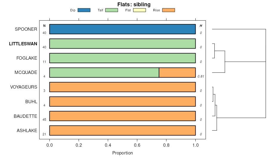
| Spooner-Littleswan complex, 0 to 2 percent slopes | B54A | 7631 | 3115154 | 2z32h | mn001 | 1996 | 1:20000 |
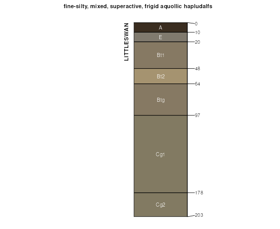
Littleswan silt loam, 0 to 3 percent slopes | B57A | 3616 | 3115153 | 2z32g | mn001 | 1996 | 1:20000 |
Baudette-Littleswan complex, 0 to 6 percent slopes | B57B | 1294 | 3115152 | 2z32f | mn001 | 1996 | 1:20000 |
Littleswan silt loam, 0 to 3 percent slopes | B57A | 1774 | 3115157 | 2z32g | mn007 | 1991 | 1:24000 |
Baudette-Littleswan complex, 0 to 6 percent slopes | B57B | 1168 | 3115156 | 2z32f | mn007 | 1991 | 1:24000 |
Spooner-Littleswan complex, 0 to 2 percent slopes | B54A | 155 | 3115158 | 2z32h | mn007 | 1991 | 1:24000 |
Spooner-Littleswan complex, 0 to 2 percent slopes | B54A | 755 | 3115162 | 2z32h | mn021 | 1993 | 1:20000 |
Littleswan silt loam, 0 to 3 percent slopes | B57A | 699 | 3115161 | 2z32g | mn021 | 1993 | 1:20000 |
Baudette-Littleswan complex, 0 to 6 percent slopes | B57B | 167 | 3115160 | 2z32f | mn021 | 1993 | 1:20000 |
Littleswan silt loam, 0 to 3 percent slopes | B57A | 9295 | 3115165 | 2z32g | mn061 | 1982 | 1:24000 |
Baudette-Littleswan complex, 0 to 6 percent slopes | B57B | 7844 | 3115164 | 2z32f | mn061 | 1982 | 1:24000 |
Spooner-Littleswan complex, 0 to 2 percent slopes | B54A | 6392 | 3115166 | 2z32h | mn061 | 1982 | 1:24000 |
Spooner-Littleswan complex, 0 to 2 percent slopes | B54A | 7103 | 3115170 | 2z32h | mn077 | 1989 | 1:24000 |
Littleswan silt loam, 0 to 3 percent slopes | B57A | 3810 | 3115169 | 2z32g | mn077 | 1989 | 1:24000 |
Baudette-Littleswan complex, 0 to 6 percent slopes | B57B | 3060 | 3115168 | 2z32f | mn077 | 1989 | 1:24000 |
Spooner-Littleswan complex, 0 to 2 percent slopes | B54A | 2448 | 3115174 | 2z32h | mn135 | 1999 | 1:24000 |
Littleswan silt loam, 0 to 3 percent slopes | B57A | 2385 | 3115173 | 2z32g | mn135 | 1999 | 1:24000 |
Baudette-Littleswan complex, 0 to 6 percent slopes | B57B | 451 | 3115172 | 2z32f | mn135 | 1999 | 1:24000 |
Baudette-Littleswan complex, 1 to 8 percent slopes | F192B | 8445 | 2407949 | 2ltns | mn613 | 2016 | 1:24000 |
Littleswan-Spooner complex, 0 to 3 percent slopes | F191A | 4989 | 2407950 | 2ltnt | mn613 | 2016 | 1:24000 |
Baudette-Littleswan complex, 0 to 8 percent slopes | 2srqy | 771 | 2943728 | 2srqy | mn613 | 2016 | 1:24000 |
Littleswan-Spooner complex, 0 to 3 percent slopes | 2srr4 | 287 | 2943912 | 2srr4 | mn613 | 2016 | 1:24000 |
Voyageurs, oxyaquic-Littleswan-Conic, very stony complex, 0 to 12 percent slopes, rocky | 2srqv | 101 | 2943726 | 2wgm0 | mn613 | 2016 | 1:24000 |
Spooner-Littleswan complex, 0 to 2 percent slopes | B54A | 302 | 3115178 | 2z32h | mn617 | 2007 | 1:24000 |
Littleswan silt loam, 0 to 3 percent slopes | B57A | 205 | 3115177 | 2z32g | mn617 | 2007 | 1:24000 |
Spooner-Buhl-Littleswan complex, 0 to 3 percent slopes | B73A | 84 | 1861498 | 20h1b | mn617 | 2007 | 1:24000 |
Baudette-Littleswan complex, 0 to 6 percent slopes | B57B | 35 | 3115176 | 2z32f | mn617 | 2007 | 1:24000 |
Spooner-Littleswan complex, 0 to 2 percent slopes | B54A | 7381 | 3115182 | 2z32h | mn619 | 2009 | 1:24000 |
Littleswan silt loam, 0 to 3 percent slopes | B57A | 6956 | 3115181 | 2z32g | mn619 | 2009 | 1:24000 |
Baudette-Littleswan complex, 0 to 6 percent slopes | B57B | 5459 | 3115180 | 2z32f | mn619 | 2009 | 1:24000 |
Lahti-Gowan-Littleswan complex, 1 to 3 percent slopes | B267B | 1056 | 2425669 | 2mf3d | mn619 | 2009 | 1:24000 |
Alborn-Littleswan complex, 0 to 3 percent slopes | B270A | 980 | 1946792 | 23bsr | mn619 | 2009 | 1:24000 |
Spooner-Buhl-Littleswan complex, 0 to 3 percent slopes | B73A | 589 | 1946869 | 23bw7 | mn619 | 2009 | 1:24000 |
Spooner-Littleswan complex, 0 to 2 percent slopes | B54A | 915 | 3115186 | 2z32h | mn621 | 2006 | 1:24000 |
Littleswan silt loam, 0 to 3 percent slopes | B57A | 641 | 3115185 | 2z32g | mn621 | 2006 | 1:24000 |
Spooner-Buhl-Littleswan complex, 0 to 3 percent slopes | B73A | 314 | 843501 | x9qq | mn621 | 2006 | 1:24000 |
Baudette-Littleswan complex, 0 to 6 percent slopes | B57B | 77 | 3115184 | 2z32f | mn621 | 2006 | 1:24000 |
Spooner-Littleswan complex, 0 to 2 percent slopes | B54A | 10970 | 3115190 | 2z32h | mn625 | 2015 | 1:24000 |
Baudette-Littleswan complex, 0 to 6 percent slopes | B57B | 8800 | 3115188 | 2z32f | mn625 | 2015 | 1:24000 |
Littleswan silt loam, 0 to 3 percent slopes | B57A | 6535 | 3115189 | 2z32g | mn625 | 2015 | 1:24000 |
Baudette-Littleswan complex, 1 to 8 percent slopes | F192B | 5440 | 2943824 | 2pfty | mn625 | 2015 | 1:24000 |
Littleswan-Spooner complex, 0 to 3 percent slopes | F191A | 4605 | 2943823 | 2pftv | mn625 | 2015 | 1:24000 |
Littleswan-Spooner complex, 0 to 3 percent slopes | 2srr4 | 930 | 2943869 | 2srr4 | mn625 | 2015 | 1:24000 |
Voyageurs, oxyaquic-Littleswan-Conic, very stony complex, 0 to 12 percent slopes, rocky | 2srqv | 203 | 2943878 | 2wgm0 | mn625 | 2015 | 1:24000 |
Voyageurs, oxyaquic-Littleswan-Conic, very stony complex, 0 to 12 percent slopes, rocky | 2srqv | 4424 | 2742237 | 2wgm0 | mn627 | 2015 | 1:12000 |
Littleswan-Spooner complex, 0 to 3 percent slopes | 2srr4 | 4248 | 2742245 | 2srr4 | mn627 | 2015 | 1:12000 |
Baudette-Littleswan complex, 0 to 8 percent slopes | 2srqy | 290 | 2742240 | 2srqy | mn627 | 2015 | 1:12000 |


