| Linoyer-Heist association | 1100 | 34 | 2480497 | 2p851 | nv713 | 2014 | 1:24000 |
Blimo-Kunzler-Linoyer association | 1210 | 17087 | 478605 | j20w | nv766 | 1994 | 1:24000 |
Linoyer-Okan association | 371 | 11649 | 478311 | j1qd | nv766 | 1994 | 1:24000 |
Palinor-Shabliss-Linoyer association | 857 | 10554 | 478503 | j1xl | nv766 | 1994 | 1:24000 |
Wintermute-Linoyer association | 119 | 9350 | 478221 | j1mh | nv766 | 1994 | 1:24000 |
Timpie-Piltdown-Linoyer association | 373 | 7140 | 478313 | j1qg | nv766 | 1994 | 1:24000 |
Toano-Linoyer association | 101 | 7104 | 478208 | j1m2 | nv766 | 1994 | 1:24000 |
Tulase-Linoyer association | 1480 | 6343 | 478648 | j228 | nv766 | 1994 | 1:24000 |
Zerk-Automal-Linoyer association | 900 | 6042 | 478518 | j1y2 | nv766 | 1994 | 1:24000 |
Shabliss-Tulase-Linoyer association | 700 | 4502 | 478434 | 2wbj1 | nv766 | 1994 | 1:24000 |
Sodhouse-Linoyer association | 496 | 4232 | 478359 | j1ry | nv766 | 1994 | 1:24000 |
Wintermute-Linoyer-Okan association | 174 | 4044 | 478240 | j1n3 | nv766 | 1994 | 1:24000 |
Palinor-Automal-Linoyer association | 858 | 3762 | 478504 | j1xm | nv766 | 1994 | 1:24000 |
Threesee-Linoyer-Okan association | 1411 | 1527 | 478635 | j21v | nv766 | 1994 | 1:24000 |
Keefa-Lyx-Linoyer association | 3747 | 2464 | 2634084 | 2rn3s | nv776 | 1983 | 1:63360 |
Linoyer-Clowfin association | 3973 | 1023 | 2634090 | 2rn3z | nv776 | 1983 | 1:63360 |
Linoyer very fine sandy loam, 2 to 6 percent slopes | 8117 | 830 | 3423199 | 312v7 | nv776 | 1983 | 1:63360 |
Linoyer-Heist-Tulase association | 232 | 419 | 2634045 | 2rn2h | nv776 | 1983 | 1:63360 |
Linoyer very fine sandy loam, 0 to 4 percent slopes | 3972 | 341 | 2634089 | 2rn3y | nv776 | 1983 | 1:63360 |
Linoyer-Rebel association | 3970 | 153 | 2634088 | 2rn3x | nv776 | 1983 | 1:63360 |
Shabliss-Tulase-Linoyer association | 6455 | 8 | 2215797 | 2dcqb | nv778 | 2013 | 1:24000 |
Linoyer-Escalante association | 3170 | 10033 | 480012 | j3h8 | nv779 | 2004 | 1:24000 |
Toano-Linoyer association | 1030 | 2909 | 479923 | j3dd | nv779 | 2004 | 1:24000 |
Rouette-Linoyer association | 3218 | 2623 | 480033 | j3hy | nv779 | 2004 | 1:24000 |
Linoyer-Tulase-Shabliss association | 3177 | 1055 | 480014 | j3hb | nv779 | 2004 | 1:24000 |
Jericho-Linoyer association | 1298 | 968 | 479947 | j3f5 | nv779 | 2004 | 1:24000 |
Wintermute-Linoyer association | 1040 | 580 | 479924 | j3df | nv779 | 2004 | 1:24000 |
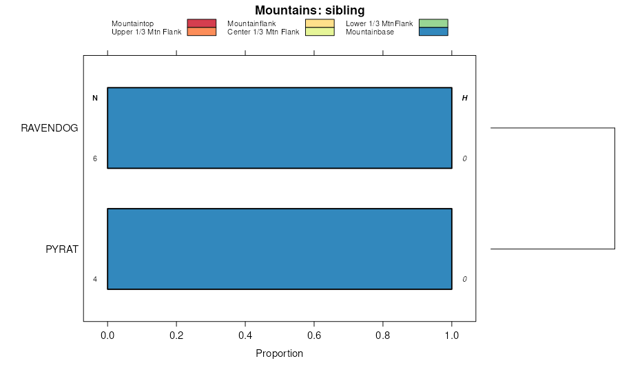
Pyrat-Linoyer association | 1121 | 223 | 479935 | j3ds | nv779 | 2004 | 1:24000 |
Shabliss-Tulase-Linoyer association | 455 | 19179 | 480487 | 2wbj1 | nv780 | 1990 | 1:24000 |
Linoyer-Heist-Tulase association | 232 | 18772 | 480357 | j3vd | nv780 | 1990 | 1:24000 |
Pyrat-Linoyer association | 189 | 14210 | 480336 | j3tq | nv780 | 1990 | 1:24000 |
Blimo-Linoyer-Tulase association | 992 | 7375 | 480655 | j450 | nv780 | 1990 | 1:24000 |
Tosser-Pyrat-Linoyer association | 166 | 5925 | 480306 | j3sr | nv780 | 1990 | 1:24000 |
Kunzler-Linoyer association | 642 | 4270 | 480561 | j41z | nv780 | 1990 | 1:24000 |
Pyrat-Shabliss-Linoyer association | 1492 | 3826 | 480278 | j3rv | nv780 | 1990 | 1:24000 |
Linoyer very fine sandy loam, 0 to 4 percent slopes | 231 | 2640 | 480356 | 2whnh | nv780 | 1990 | 1:24000 |
Linoyer-Katelana association | 230 | 2135 | 480355 | j3vb | nv780 | 1990 | 1:24000 |
Linoyer silt loam, 0 to 2 percent slopes | 233 | 1120 | 480358 | j3vf | nv780 | 1990 | 1:24000 |
Linoyer-Rebel association | 1970 | 11733 | 480839 | j4by | nv781 | 1994 | 1:24000 |
Linoyer very fine sandy loam, 2 to 6 percent slopes | 8117 | 2339 | 3423007 | 312v7 | nv782 | 2025 | 1:24000 |
Linoyer-Rebel association | 3970 | 26815 | 481083 | j4lt | nv783 | 1991 | 1:24000 |
Linoyer-Kunzler association | 3974 | 20983 | 481087 | j4ly | nv783 | 1991 | 1:24000 |
Linoyer very fine sandy loam, 0 to 4 percent slopes | 3972 | 10892 | 481085 | 2whnh | nv783 | 1991 | 1:24000 |
Linoyer-Easychair association | 3971 | 1859 | 481084 | j4lv | nv783 | 1991 | 1:24000 |
Keefa-Lyx-Linoyer association | 3747 | 1437 | 481040 | j4kf | nv783 | 1991 | 1:24000 |
Linoyer-Clowfin association | 3973 | 1190 | 481086 | j4lx | nv783 | 1991 | 1:24000 |
Linoyer very fine sandy loam, 2 to 6 percent slopes | 8117 | 67 | 3477230 | 312v7 | nv783 | 1991 | 1:24000 |
Chuffa-Linoyer-Playas complex | 2071 | 23785 | 481190 | j4q8 | nv784 | 2006 | 1:24000 |
Linoyer-Heist association | 1100 | 18178 | 481126 | j4n6 | nv784 | 2006 | 1:24000 |
Crestline-Linoyer association | 2061 | 1410 | 481188 | j4q6 | nv784 | 2006 | 1:24000 |
Linoyer-Escalante association | 3170 | 690 | 1395629 | 1hv89 | nv784 | 2006 | 1:24000 |
Linoyer very fine sandy loam, 2 to 5 percent slopes | LaC | 35082 | 482539 | 2smc4 | ut608 | 1981 | 1:24000 |
Linoyer very fine sandy loam, 5 to 10 percent slopes, eroded | LaD2 | 4317 | 482540 | j63t | ut608 | 1981 | 1:24000 |
Linoyer very fine sandy loam, 0 to 1 percent slopes | LaA | 3402 | 482537 | j63q | ut608 | 1981 | 1:24000 |
Linoyer very fine sandy loam, 1 to 2 percent slopes | LaB | 2771 | 482538 | j63r | ut608 | 1981 | 1:24000 |
Thiokol-Linoyer complex, 0 to 5 percent slopes | TcC | 1773 | 482634 | j66v | ut608 | 1981 | 1:24000 |
Linoyer loam, 0 to 2 percent slopes | 82 | 2712 | 481881 | j5fk | ut618 | 1995 | 1:24000 |
Kessler-Linoyer complex, 0 to 2 percent slopes | 75 | 2211 | 481871 | j5f7 | ut618 | 1995 | 1:24000 |
Heist-Linoyer complex, 0 to 8 percent slopes | 55 | 981 | 481849 | j5dj | ut618 | 1995 | 1:24000 |
Linoyer very fine sandy loam, 2 to 5 percent slopes | 83 | 915 | 481882 | 2smc4 | ut618 | 1995 | 1:24000 |
Linoyer very fine sandy loam, 2 to 5 percent slopes, eroded | LdC2 | 5720 | 482278 | j5vc | ut627 | 1971 | 1:24000 |
Linoyer very fine sandy loam, 1 to 2 percent slopes | LdB | 2780 | 482277 | j5vb | ut627 | 1971 | 1:24000 |
Linoyer very fine sandy loam, 2 to 5 percent slopes, eroded | 163 | 23 | 483551 | j75f | ut628 | | 1:24000 |


