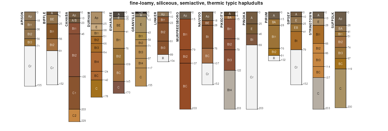
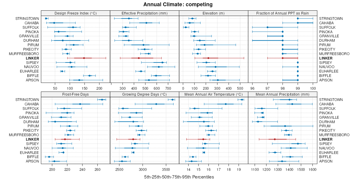
| Linker fine sandy loam, 6 to 10 percent slopes | LeC | 22209 | 328380 | 2t8fy | al009 | 1974 | 1:24000 |
Linker fine sandy loam, 2 to 6 percent slopes | LeB | 9731 | 328379 | 2sr8x | al009 | 1974 | 1:24000 |
Linker fine sandy loam, 10 to 15 percent slopes | LeD | 6560 | 328381 | 2t8g0 | al009 | 1974 | 1:24000 |
Linker-Hector complex, 2 to 10 percent slopes | LhC | 2873 | 328382 | c0pz | al009 | 1974 | 1:24000 |
Linker gravelly fine sandy loam, 6 to 10 percent slopes, eroded | LnC2 | 217 | 523350 | kkl8 | al015 | 1959 | 1:20000 |
Linker fine sandy loam, 6 to 10 percent slopes | LdC | 1954 | 523018 | kk7k | al019 | 1973 | 1:20000 |
Linker fine sandy loam, 2 to 6 percent slopes | LdB | 1371 | 523017 | 2sr8x | al019 | 1973 | 1:20000 |
Linker cobbly sandy loam, 6 to 15 percent slopes | LkD | 671 | 328511 | c0v4 | al021 | 1967 | 1:20000 |
Linker gravelly sandy loam, 6 to 10 percent slopes | LgC | 261 | 328510 | c0v3 | al021 | 1967 | 1:20000 |
Linker sandy loam, 2 to 6 percent slopes | LeB | 139 | 328509 | c0v2 | al021 | 1967 | 1:20000 |
Linker fine sandy loam, 6 to 10 percent slopes, eroded | LkC2 | 17924 | 328922 | 2t8ft | al043 | 1960 | 1:20000 |
Linker fine sandy loam, 6 to 10 percent slopes | LkC | 3556 | 328921 | 2t8fy | al043 | 1960 | 1:20000 |
Linker fine sandy loam, 10 to 15 percent slopes, eroded | LkD2 | 2882 | 328925 | 2t8g1 | al043 | 1960 | 1:20000 |
Linker fine sandy loam, 10 to 15 percent slopes | LkD | 1389 | 328924 | 2t8g0 | al043 | 1960 | 1:20000 |
Linker fine sandy loam, 6 to 10 percent slopes, severely eroded | LkC3 | 1338 | 328923 | c18f | al043 | 1960 | 1:20000 |
Linker fine sandy loam, 10 to 15 percent slopes, severely eroded | LkD3 | 855 | 328926 | c18j | al043 | 1960 | 1:20000 |
Linker fine sandy loam, 6 to 10 percent slopes, eroded | Le | 3000 | 329177 | 2t8ft | al049 | 1953 | 1:20000 |
Linker fine sandy loam, eroded, undulating | Lf | 1000 | 329178 | c1jn | al049 | 1953 | 1:20000 |
Linker-Townley complex, 15 to 30 percent slopes | 40 | 28280 | 329410 | 2sr8l | al055 | 1976 | 1:20000 |
Linker fine sandy loam, 6 to 15 percent slopes | 39 | 3350 | 329408 | 30v9g | al055 | 1976 | 1:20000 |
Linker-Urban land complex, 15 to 30 percent slopes | 41 | 650 | 329411 | c1s5 | al055 | 1976 | 1:20000 |
Linker fine sandy loam, 2 to 6 percent slopes | 38 | 580 | 329407 | 2sr8x | al055 | 1976 | 1:20000 |
Linker fine sandy loam, 6 to 10 percent slopes, eroded | LkC2 | 4290 | 329576 | 2t8ft | al059 | 1962 | 1:15840 |
Linker fine sandy loam, 6 to 10 percent slopes | LkC | 893 | 329575 | 2t8fy | al059 | 1962 | 1:15840 |
Linker fine sandy loam, 10 to 15 percent slopes, eroded | LkD2 | 854 | 329577 | 2t8g1 | al059 | 1962 | 1:15840 |
Linker fine sandy loam, rolling phase | Lg | 6010 | 330143 | c2js | al079 | 1950 | 1:20000 |
Linker fine sandy loam, 6 to 10 percent slopes, eroded | Le | 5930 | 330141 | 2t8ft | al079 | 1950 | 1:20000 |
Linker fine sandy loam, 10 to 20 percent slopes, eroded | Ld | 1076 | 330140 | 2wc29 | al079 | 1950 | 1:20000 |
Linker clay loam, 6 to 10 percent slopes, severely eroded | Lc | 358 | 330139 | 30v9d | al079 | 1950 | 1:20000 |
Linker sandy clay loam, severely eroded, sloping | LcC3 | 7771 | 330720 | c34d | al095 | 1956 | 1:20000 |
Linker sandy clay loam, severely eroded, gently sloping | LcB3 | 7771 | 330719 | c34c | al095 | 1956 | 1:20000 |
Linker fine sandy loam, 6 to 10 percent slopes, eroded | LbC2 | 666 | 330717 | 2t8ft | al095 | 1956 | 1:20000 |
Linker sandy clay loam, severely eroded, strongly sloping | LcD3 | 333 | 330721 | c34f | al095 | 1956 | 1:20000 |
Linker fine sandy loam, eroded, strongly sloping | LbD2 | 139 | 330718 | c34b | al095 | 1956 | 1:20000 |
Linker fine sandy loam, 6 to 10 percent slopes, eroded | Lf | 7975 | 331116 | 2t8ft | al103 | 1949 | 1:15840 |
Linker loam, 6 to 10 percent slopes, severely eroded | Ll | 1885 | 331120 | 2sr8y | al103 | 1949 | 1:15840 |
Linker fine sandy loam, rolling | Lh | 1528 | 331118 | c3k7 | al103 | 1949 | 1:15840 |
Linker fine sandy loam, 10 to 20 percent slopes, eroded | Le | 344 | 331115 | 2wc29 | al103 | 1949 | 1:15840 |
Linker fine sandy loam, 3 to 8 percent slopes | LrC | 4696 | 565037 | lyz0 | ar007 | 1973 | 1:20000 |
Linker fine sandy loam, 3 to 8 percent slopes | 22 | 3585 | 565108 | lz19 | ar009 | 1977 | 1:20000 |
Linker-Mountainburg complex, 8 to 20 percent slopes | 24 | 2847 | 565110 | lz1c | ar009 | 1977 | 1:20000 |
Linker gravelly fine sandy loam, 3 to 8 percent slopes | 23 | 1941 | 565109 | 2sntb | ar009 | 1977 | 1:20000 |
Linker loam, 3 to 8 percent slopes | 16 | 8690 | 565220 | 2snt9 | ar015 | 1981 | 1:20000 |
Linker-Mountainburg complex, 8 to 20 percent slopes | 18 | 4930 | 565222 | lz4z | ar015 | 1981 | 1:20000 |
Linker-Mountainburg complex, 3 to 8 percent slopes | 17 | 2330 | 565221 | lz4y | ar015 | 1981 | 1:20000 |
Steprock-Linker complex, 3 to 8 percent slopes | 29 | 37466 | 3086051 | 2sp1w | ar023 | 1983 | 1:20000 |
Linker-Mountainburg gravelly fine sandy loams, 3 to 8 percent slopes | 18 | 15493 | 3086039 | 2sntg | ar023 | 1983 | 1:20000 |
Linker gravelly fine sandy loam, 3 to 8 percent slopes | 16 | 14663 | 3086037 | 2sntb | ar023 | 1983 | 1:20000 |
Linker fine sandy loam, 3 to 8 percent slopes | 15 | 10445 | 3086036 | 2sp0t | ar023 | 1983 | 1:20000 |
Linker-Mountainburg complex, 8 to 20 percent slopes | 19 | 2619 | 3086040 | lyqh | ar023 | 1983 | 1:20000 |
Linker gravelly fine sandy loam, 8 to 12 percent slopes | 17 | 990 | 3086038 | 2sp0r | ar023 | 1983 | 1:20000 |
Linker fine sandy loam, 3 to 8 percent slopes | 16 | 58333 | 565382 | 2sp0t | ar029 | 1977 | 1:20000 |
Linker fine sandy loam, 8 to 12 percent slopes | 17 | 28919 | 565383 | 2spfn | ar029 | 1977 | 1:20000 |
Linker fine sandy loam, 1 to 3 percent slopes | 15 | 4620 | 565381 | 2sp0s | ar029 | 1977 | 1:20000 |
Linker fine sandy loam, 3 to 8 percent slopes | 14 | 20723 | 565417 | 2sp0t | ar033 | 1975 | 1:20000 |
Linker-Mountainburg association, undulating | 15 | 4586 | 565418 | lzc9 | ar033 | 1975 | 1:20000 |
Linker fine sandy loam, 3 to 8 percent slopes | 11 | 77030 | 565486 | 2sp0t | ar045 | 1975 | 1:20000 |
Linker fine sandy loam, 1 to 3 percent slopes | 10 | 11283 | 565485 | 2sp0s | ar045 | 1975 | 1:20000 |
Linker fine sandy loam, 8 to 12 percent slopes | 12 | 9386 | 565487 | 2spfn | ar045 | 1975 | 1:20000 |
Linker-Mountainburg association, 12 to 40 percent slopes, rocky | 14 | 8981 | 565489 | 2vz88 | ar045 | 1975 | 1:20000 |
Linker-Mountainburg association, 8 to 12 percent slopes | 13 | 4485 | 565488 | 2vz89 | ar045 | 1975 | 1:20000 |
Linker fine sandy loam, 3 to 8 percent slopes | LnC | 31520 | 565566 | 2sp0t | ar047 | 1967 | 1:20000 |
Linker-Mountainburg gravelly fine sandy loams, 3 to 8 percent slopes | LMB | 5873 | 565560 | 2sntg | ar047 | 1967 | 1:20000 |
Linker fine sandy loam, 1 to 3 percent slopes | LnB | 3689 | 565565 | 2sp0s | ar047 | 1967 | 1:20000 |
Linker soils, gently rolling | LKB | 1462 | 565559 | lzhv | ar047 | 1967 | 1:20000 |
Linker fine sandy loam, 8 to 12 percent slopes | LnD | 621 | 565567 | 2spfn | ar047 | 1967 | 1:20000 |
Linker gravelly fine sandy loam, 8 to 12 percent slopes | 36 | 23000 | 565757 | 2sp0r | ar063 | 1980 | 1:20000 |
Linker fine sandy loam, 3 to 8 percent slopes | 33 | 19041 | 565754 | 2sp0t | ar063 | 1980 | 1:20000 |
Linker gravelly fine sandy loam, 3 to 8 percent slopes | 35 | 13774 | 565756 | 2sntb | ar063 | 1980 | 1:20000 |
Linker gravelly fine sandy loam, 12 to 30 percent slopes | 37 | 11476 | 565758 | lzq8 | ar063 | 1980 | 1:20000 |
Linker fine sandy loam, 8 to 12 percent slopes | 34 | 4344 | 565755 | 2spfn | ar063 | 1980 | 1:20000 |
Linker-Hector complex, 12 to 40 percent slopes | LhF | 4745 | 565816 | lzs4 | ar067 | 1971 | 1:20000 |
Linker fine sandy loam, 3 to 8 percent slopes | LfC | 1455 | 565815 | 2sp0t | ar067 | 1971 | 1:20000 |
Linker fine sandy loam, 3 to 8 percent slopes | LnC | 45538 | 565841 | 2sp0t | ar071 | 1973 | 1:24000 |
Linker-Mountainburg association, rolling | LMD | 13457 | 565837 | lzst | ar071 | 1973 | 1:24000 |
Linker fine sandy loam, 1 to 3 percent slopes | LnB | 2886 | 565840 | 2sp0s | ar071 | 1973 | 1:24000 |
Linker association, rolling | LKD | 1458 | 565836 | lzss | ar071 | 1973 | 1:24000 |
Linker fine sandy loam, 8 to 12 percent slopes | LnD | 1399 | 565842 | 2spfn | ar071 | 1973 | 1:24000 |
Linker fine sandy loam, 3 to 8 percent slopes | 18 | 42576 | 565881 | 2sp0t | ar083 | 1977 | 1:20000 |
Linker loam, 3 to 8 percent slopes | 23 | 8803 | 565923 | 2snt9 | ar087 | 1982 | 1:20000 |
Linker-Mountainburg complex, 8 to 20 percent slopes | 25 | 7771 | 566006 | lzz8 | ar101 | 1984 | 1:20000 |
Linker-Mountainburg complex, 3 to 8 percent slopes | 24 | 6266 | 566005 | lzz7 | ar101 | 1984 | 1:20000 |
Linker loam, 3 to 8 percent slopes | 22 | 5289 | 566003 | 2snt9 | ar101 | 1984 | 1:20000 |
Linker gravelly loam, 3 to 8 percent slopes | 23 | 4479 | 566004 | lzz6 | ar101 | 1984 | 1:20000 |
Linker fine sandy loam, 8 to 12 percent slopes | 19 | 2120 | 566090 | 2spfn | ar105 | 1980 | 1:20000 |
Linker fine sandy loam, 3 to 8 percent slopes | 18 | 1570 | 566089 | 2sp0t | ar105 | 1980 | 1:20000 |
Linker fine sandy loam, 3 to 8 percent slopes | 17 | 68273 | 566121 | 2sp0t | ar115 | 1978 | 1:20000 |
Linker-Mountainburg association, gently rolling | 19 | 6994 | 566123 | m031 | ar115 | 1978 | 1:20000 |
Linker-Mountainburg association, rolling | 20 | 5054 | 566125 | m033 | ar115 | 1978 | 1:20000 |
Linker fine sandy loam, 1 to 3 percent slopes | 16 | 901 | 566120 | 2sp0s | ar115 | 1978 | 1:20000 |
Linker fine sandy loam, 8 to 12 percent slopes | 18 | 524 | 566122 | 2spfn | ar115 | 1978 | 1:20000 |
Linker-Mountainburg association, 12 to 25 percent slopes, rocky | LRE | 29191 | 566179 | 2vz86 | ar119 | 1972 | 1:20000 |
Linker gravelly fine sandy loam, 3 to 8 percent slopes | LkC | 19959 | 566185 | 2sntb | ar119 | 1972 | 1:20000 |
Linker-Urban land complex, 3 to 8 percent slopes | LnC | 7963 | 566186 | m052 | ar119 | 1972 | 1:20000 |
Linker fine sandy loam, 3 to 8 percent slopes | 15 | 1480 | 566222 | m067 | ar125 | 1976 | 1:20000 |
Linker-Mountainburg complex, 3 to 8 percent slopes | LMC | 3112 | 566348 | m0b9 | ar127 | 1993 | 1:20000 |
Linker gravelly fine sandy loam, 3 to 8 percent slopes | 34C | 6896 | 566467 | 2sntb | ar129 | 1987 | 1:20000 |
Linker Mountainburg complex, 3 to 8 percent slopes | 36C | 5414 | 566469 | 2sp10 | ar129 | 1987 | 1:20000 |
Linker-Mountainburg complex, 8 to 20 percent slopes, very rocky, extremely stony | 36DE | 4438 | 566470 | 2sp0z | ar129 | 1987 | 1:20000 |
Linker fine sandy loam, 3 to 8 percent slopes | 32C | 1813 | 566466 | 2sp0t | ar129 | 1987 | 1:20000 |
Linker gravelly fine sandy loam, 8 to 12 percent slopes | 34D | 1219 | 566468 | 2sp0r | ar129 | 1987 | 1:20000 |
Linker fine sandy loam, 3 to 8 percent slopes | LnC | 6990 | 566382 | 2sp0t | ar131 | 1971 | 1:20000 |
Linker gravelly fine sandy loam, 3 to 8 percent slopes | 16 | 18911 | 566407 | 2sntb | ar137 | 1981 | 1:20000 |
Linker-Mountainburg complex, 8 to 20 percent slopes, very rocky, extremely stony | 19 | 18105 | 566410 | 2sp0z | ar137 | 1981 | 1:20000 |
Linker Mountainburg complex, 3 to 8 percent slopes | 18 | 11598 | 566409 | 2sp10 | ar137 | 1981 | 1:20000 |
Linker fine sandy loam, 3 to 8 percent slopes | 15 | 9223 | 566406 | 2sp0t | ar137 | 1981 | 1:20000 |
Linker gravelly fine sandy loam, 8 to 12 percent slopes | 17 | 5998 | 566408 | 2sp0r | ar137 | 1981 | 1:20000 |
Steprock-Linker complex, 3 to 8 percent slopes | 29 | 50361 | 3086198 | 2sp1w | ar141 | 1983 | 1:20000 |
Linker gravelly fine sandy loam, 3 to 8 percent slopes | 16 | 12773 | 3086184 | 2sntb | ar141 | 1983 | 1:20000 |
Linker-Mountainburg gravelly fine sandy loams, 3 to 8 percent slopes | 18 | 9434 | 3086186 | 2sntg | ar141 | 1983 | 1:20000 |
Linker-Mountainburg complex, 8 to 20 percent slopes | 19 | 5015 | 3086187 | lyqh | ar141 | 1983 | 1:20000 |
Linker fine sandy loam, 3 to 8 percent slopes | 15 | 526 | 3086183 | 2sp0t | ar141 | 1983 | 1:20000 |
Linker gravelly fine sandy loam, 8 to 12 percent slopes | 17 | 260 | 3086185 | 2sp0r | ar141 | 1983 | 1:20000 |
Linker loam, 3 to 8 percent slopes, eroded | LkC2 | 17012 | 566599 | m0ld | ar143 | 1966 | 1:20000 |
Linker gravelly loam, 3 to 8 percent slopes, eroded | LnC2 | 4894 | 566600 | m0lf | ar143 | 1966 | 1:20000 |
Linker loam, 1 to 3 percent slopes | LkB | 980 | 566598 | m0lc | ar143 | 1966 | 1:20000 |
Linker gravelly loam, 8 to 12 percent slopes | LnD | 847 | 566601 | m0lg | ar143 | 1966 | 1:20000 |
Linker fine sandy loam, 3 to 8 percent slopes | 19 | 82613 | 566645 | 2sp0t | ar145 | 1980 | 1:20000 |
Linker gravelly fine sandy loam, 3 to 8 percent slopes | 20 | 34946 | 566647 | 2sntb | ar145 | 1980 | 1:20000 |
Steprock-Linker complex, 3 to 8 percent slopes | 33 | 17632 | 566661 | 2sp1w | ar145 | 1980 | 1:20000 |
Linker fine sandy loam, 3 to 8 percent slopes | 28 | 21294 | 564986 | 2sp0t | ar149 | 1985 | 1:20000 |
Linker-Mountainburg complex, 1 to 8 percent slopes | 29 | 14943 | 564987 | lyxd | ar149 | 1985 | 1:20000 |
Linker-Enders-Mountainburg complex, 12 to 25 percent slopes | 20 | 4232 | 564303 | ly6b | ar680 | 1980 | 1:20000 |
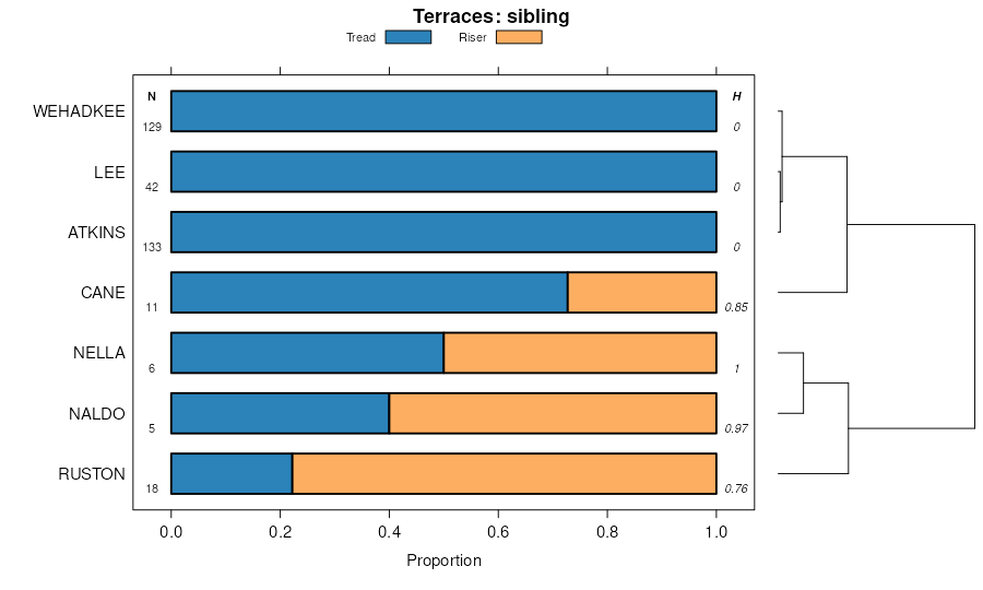
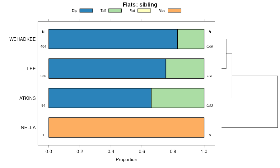
Linker-Nella complex, 35 to 60 percent slopes | LnF | 430 | 2023785 | 25xxd | ga129 | 2007 | 1:12000 |
Linker-Nella complex, 20 to 35 percent slopes | LnE | 320 | 2023784 | 25xxc | ga129 | 2007 | 1:12000 |
Linker fine sandy loam, 10 to 25 percent slopes | LkE | 1885 | 531277 | kttz | ga621 | 1975 | 1:20000 |
Linker fine sandy loam, 6 to 10 percent slopes | LkC | 1685 | 531276 | ktty | ga621 | 1975 | 1:20000 |
Ruston-Shubuta-Linker association, hilly | RuE | 28558 | 331752 | c46p | ms003 | 1967 | 1:20000 |
Ruston-Linker association, hilly | RtE | 12890 | 331751 | c46n | ms003 | 1967 | 1:20000 |
Enders-Linker-Hector association, 5 to 30 percent slopes | Hc | 81010 | 571786 | 2pwxm | ok001 | 1963 | 1:24000 |
Hector-Linker complex, 1 to 5 percent slopes | HlC | 12560 | 571787 | 2vz8b | ok001 | 1963 | 1:24000 |
Linker fine sandy loam, 3 to 5 percent slopes | LkC | 2750 | 571792 | 2sp11 | ok001 | 1963 | 1:24000 |
Linker loam, 3 to 5 percent slopes | LnC | 1504 | 571794 | m5zz | ok001 | 1963 | 1:24000 |
Linker fine sandy loam, 3 to 5 percent slopes, eroded | LkC2 | 589 | 571793 | m5zy | ok001 | 1963 | 1:24000 |
Linker loam, 3 to 5 percent slopes, eroded | LnC2 | 578 | 571795 | m600 | ok001 | 1963 | 1:24000 |
Enders-Linker-Hector association, 5 to 30 percent slopes | HlE | 89570 | 571816 | 2pwxm | ok021 | 1967 | 1:24000 |
Linker fine sandy loam, 3 to 5 percent slopes | LkC | 6045 | 571818 | 2sp11 | ok021 | 1967 | 1:24000 |
Hector-Linker association, 8 to 30 percent slopes | HlE | 50 | 571858 | m621 | ok041 | 1967 | 1:24000 |
Linker fine sandy loam, 3 to 5 percent slopes | LkC | 37 | 571860 | m623 | ok041 | 1967 | 1:24000 |
Hector-Linker complex, 3 to 5 percent slopes | HlC | 27976 | 571684 | 2vz80 | ok061 | 1972 | 1:24000 |
Linker fine sandy loam, 3 to 5 percent slopes, eroded | LkC2 | 15480 | 571692 | m5wp | ok061 | 1972 | 1:24000 |
Linker-Hector complex, 3 to 8 percent slopes, severely eroded | LnD3 | 11120 | 571693 | m5wq | ok061 | 1972 | 1:24000 |
Linker fine sandy loam, 1 to 3 percent slopes | LkB | 2301 | 571690 | 2spfr | ok061 | 1972 | 1:24000 |
Linker fine sandy loam, 3 to 5 percent slopes | LkC | 1543 | 571691 | 2sp11 | ok061 | 1972 | 1:24000 |
Linker-Hector complex, 3 to 5 percent slopes | 40 | 28532 | 571752 | 2vz8c | ok091 | 1980 | 1:24000 |
Linker fine sandy loam, 3 to 5 percent slopes | 38 | 14817 | 571749 | 2sp11 | ok091 | 1980 | 1:24000 |
Linker fine sandy loam, 1 to 3 percent slopes | 37 | 7735 | 571748 | 2spfr | ok091 | 1980 | 1:24000 |
Linker fine sandy loam, 3 to 5 percent slopes, severely eroded | 39 | 2379 | 571750 | m5yk | ok091 | 1980 | 1:24000 |
Hector-Enders-Linker complex, 1 to 5 percent slopes | HeC | 6120 | 106556 | 2ydtf | ok097 | 1972 | 1:24000 |
Enders-Linker-Hector association, 5 to 30 percent slopes | 18 | 40886 | 106378 | 3kpk | ok101 | 1984 | 1:24000 |
Linker fine sandy loam, 3 to 5 percent slopes | 38 | 1875 | 106400 | 2sp11 | ok101 | 1984 | 1:24000 |
Linker fine sandy loam, 1 to 3 percent slopes | 37 | 1535 | 106399 | 2spfr | ok101 | 1984 | 1:24000 |
Hector-Linker complex, 1 to 5 percent slopes | HlC | 12711 | 106664 | 2wwdn | ok131 | 1963 | 1:24000 |
Linker fine sandy loam, 1 to 3 percent slopes | LkB | 1958 | 106665 | 3kzt | ok131 | 1963 | 1:24000 |
Linker fine sandy loam, 3 to 5 percent slopes | LkC | 1129 | 106666 | 3kzv | ok131 | 1963 | 1:24000 |
Hector-Linker-Enders complex, 5 to 40 percent slopes, extremely stony | HeF | 212493 | 571887 | 2vz7t | ok135 | 1966 | 1:24000 |
Linker-Hector complex, 3 to 5 percent slopes | LnC | 35522 | 571891 | 2vz8c | ok135 | 1966 | 1:24000 |
Linker and Stigler soils, 3 to 8 percent slopes, severely eroded | LoD3 | 12561 | 571893 | m635 | ok135 | 1966 | 1:24000 |
Linker-Hector complex, 5 to 8 percent slopes | LnD | 8325 | 571892 | m634 | ok135 | 1966 | 1:24000 |
Hector-Linker complex, 1 to 5 percent slopes | 22 | 2493 | 106703 | 2vz83 | ok143 | 1975 | 1:12000 |
Hector-Linker complex, 1 to 5 percent slopes | HrC | 16466 | 106763 | 2vz83 | ok145 | 1972 | 1:24000 |
Linker fine sandy loam, 1 to 3 percent slopes | LnB | 1492 | 106772 | 3l38 | ok145 | 1972 | 1:24000 |
Linker loam, 5 to 12 percent slopes | LkC | 621 | 527908 | kqb9 | tn123 | 1974 | 1:20000 |