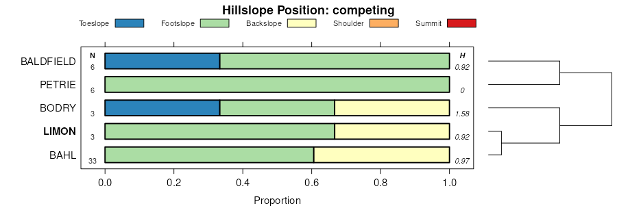
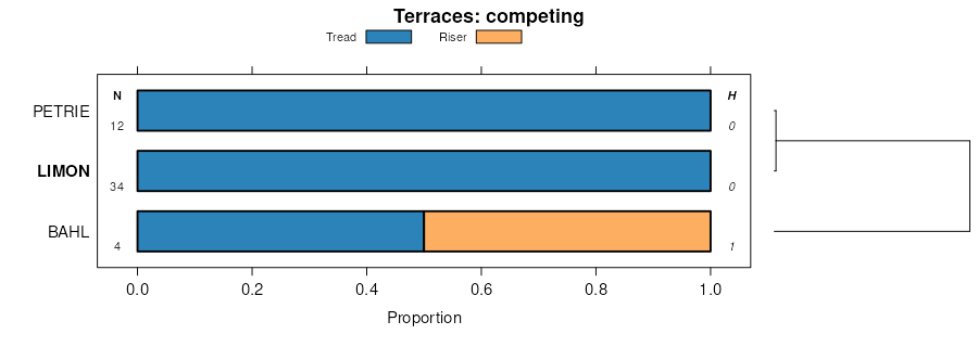
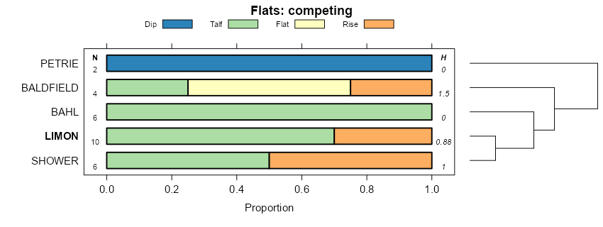
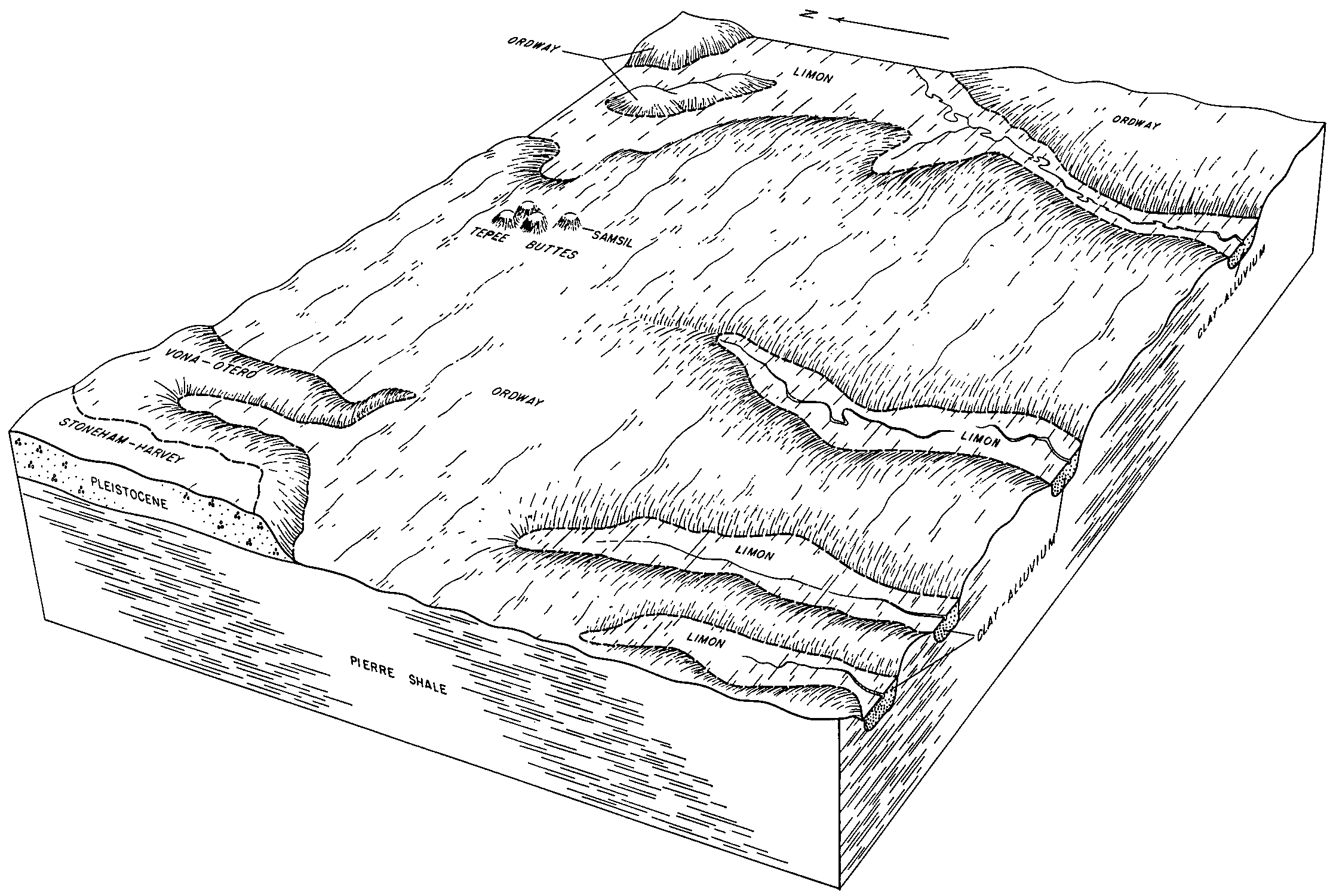
Official Series Description


Lab Data Summary

Aggregate lab data for the LIMON soil series. This aggregation is based on all pedons with a current taxon name of LIMON, and applied along 1-cm thick depth slices. Solid lines are the slice-wise median, bounded on either side by the interval defined by the slice-wise 5th and 95th percentiles. The median is the value that splits the data in half. Five percent of the data are less than the 5th percentile, and five percent of the data are greater than the 95th percentile. Values along the right hand side y-axis describe the proportion of pedon data that contribute to aggregate values at this depth. For example, a value of "90%" at 25cm means that 90% of the pedons correlated to LIMON were used in the calculation. Source: KSSL snapshot . Methods used to assemble the KSSL snapshot used by SoilWeb / SDE

Click the image to view it full size.

Pedons used in the lab summary:

MLRALab IDPedon IDTaxonnameCINSSL / NASIS ReportsLink To SoilWeb GMap
67B99P037899CO087001Limon8Primary | Supplementary | Taxonomy | Pedon | Water Retention | Correlation | Andic Soil Properties40.3055267,-103.5771942

Water Balance

Monthly water balance estimated using a leaky-bucket style model for the LIMON soil series. Monthly precipitation (PPT) and potential evapotranspiration (PET) have been estimated from the 50th percentile of gridded values (PRISM 1981-2010) overlapping with the extent of SSURGO map units containing each series as a major component. Monthly PET values were estimated using the method of Thornthwaite (1948). These (and other) climatic parameters are calculated with each SSURGO refresh and provided by the fetchOSD function of the soilDB package. Representative water storage values (“AWC” in the figures) were derived from SSURGO by taking the 50th percentile of profile-total water storage (sum[awc_r * horizon thickness]) for each soil series. Note that this representation of “water storage” is based on the average ability of most plants to extract soil water between 15 bar (“permanent wilting point”) and 1/3 bar (“field capacity”) matric potential. Soil moisture state can be roughly interpreted as “dry” when storage is depleted, “moist” when storage is between 0mm and AWC, and “wet” when there is a surplus. Clearly there are a lot of assumptions baked into this kind of monthly water balance. This is still a work in progress.

Click the image to view it full size.


Click the image to view it full size.

Sibling Summary

Siblings are those soil series that occur together in map units, in this case with the LIMON series. Sketches are arranged according to their subgroup-level taxonomic structure. Source: SSURGO snapshot , parsed OSD records and snapshot of SC database .

Click the image to view it full size.

Select annual climate data summaries for the LIMON series and siblings. Series are sorted according to hierarchical clustering of median values. Source: SSURGO map unit geometry and 1981-2010, 800m PRISM data .

Click the image to view it full size.

Geomorphic description summaries for the LIMON series and siblings. Series are sorted according to hierarchical clustering of proportions and relative hydrologic position within an idealized landform (e.g. top to bottom). Most soil series (SSURGO components) are associated with a hillslope position and one or more landform-specific positions: hills, mountain slopes, terraces, and/or flats. Proportions can be interpreted as an aggregate representation of geomorphic membership. The values printed to the left (number of component records) and right (Shannon entropy) of stacked bars can be used to judge the reliability of trends. Small Shannon entropy values suggest relatively consistent geomorphic association, while larger values suggest lack thereof. Source: SSURGO component records .

Click the image to view it full size.

Click the image to view it full size.

Click the image to view it full size.

Click the image to view it full size.

Click the image to view it full size.

Competing Series

Soil series competing with LIMON share the same family level classification in Soil Taxonomy. Source: parsed OSD records and snapshot of the SC database .

Click the image to view it full size.

Select annual climate data summaries for the LIMON series and competing. Series are sorted according to hierarchical clustering of median values. Source: SSURGO map unit geometry and 1981-2010, 800m PRISM data .

Click the image to view it full size.

Geomorphic description summaries for the LIMON series and competing. Series are sorted according to hierarchical clustering of proportions and relative hydrologic position within an idealized landform (e.g. top to bottom). Proportions can be interpreted as an aggregate representation of geomorphic membership. Most soil series (SSURGO components) are associated with a hillslope position and one or more landform-specific positions: hills, mountain slopes, terraces, and/or flats. The values printed to the left (number of component records) and right (Shannon entropy) of stacked bars can be used to judge the reliability of trends. Shannon entropy values close to 0 represent soil series with relatively consistent geomorphic association, while values close to 1 suggest lack thereof. Source: SSURGO component records .

Click the image to view it full size.

Click the image to view it full size.

There are insufficient data to create the 3D mountains figure.

Click the image to view it full size.

Click the image to view it full size.

Soil series sharing subgroup-level classification with LIMON, arranged according to family differentiae. Hovering over a series name will print full classification and a small sketch from the OSD. Source: snapshot of SC database .

Block Diagrams

Click a link below to display the diagram. Note that these diagrams may be from multiple survey areas.

  1. CO-2011-05-27-06 | Crowley County - 1968

    Relationship of soils to typography and underlying material in association 5 (Soil Survey of Crowley County, Colorado; 1968).

  2. CO-2011-05-27-07 | Otero County - 1972

    Volney-Olney-Dwyer association; part of Minnequa-Penrose soil association in background (Soil Survey of Otero County, Colorado; 1972).

  3. CO-2011-05-27-08 | Otero County - 1972

    Minnequa-Penrose association (Soil Survey of Otero County, Colorado; 1972).

  4. CO-2011-05-27-11 | Otero County - 1972

    Cross section of Otero County showing relief, drainage, and relation of soils to underlying geologic formations (Soil Survey of Otero County, Colorado; 1972).

Map Units

Map units containing LIMON as a major component. Limited to 250 records.

Map Unit Name Symbol Map Unit Area (ac) Map Unit Key National Map Unit Symbol Soil Survey Area Publication Date Map Scale
Limon clayLn302394255352hco01119651:15840
Limon clay, alkaliLo82794256352jco01119651:15840
Limon clay, alkali, 1 to 3 percent slopesLoB39528943723568co02519651:15840
Limon clay, alkali, 0 to 1 percent slopesLoA16113943713567co02519651:15840
Olney-Limon, alkali, complexOo238294390356vco02519651:15840
Limon silty clay, 1 to 3 percent slopesLnB1508943703566co02519651:15840
Limon silty clay, 0 to 1 percent slopesLnA180943693565co02519651:15840
Limon clay2312656944323586co06119771:24000
Limon clay, 0 to 3 percent slopes, rarely flooded14669491052273jhfco07320011:24000
Limon clay, moist, 0 to 3 percent slopes, rarely flooded14720361052283jhgco07320011:24000
Limon clay, 0 to 1 percent slopesLcA291915370551nlffco08719651:24000
Limon clay, saline, 0 to 1 percent slopesLsA2621104473pxtco08719651:24000
Limon silty clay, 0 to 3 percent slopesLoB105619473535kzco08919661:15840
Limon silty clay loam369689499735vfco12119821:24000
Limon clay, 0 to 3 percent slopes47934395408368pco62519751:24000
Limon silty clay loam, 0 to 2 percent slopesLnA312679550336crco62619741:24000
Limon silty clay, 0 to 2 percent slopesLoA81339550536ctco62619741:24000
Limon silty clay, 0 to 5 percent slopes,gulliedLvB71509550636cvco62619741:24000
Limon silty clay loam, 2 to 5 percent slopesLnB10279550436csco62619741:24000
Limon clay, 3 to 12 percent slopes345841496470jnm5co62719801:24000
Limon silty clay loam, 0 to 2 percent slopes335524496469jnm4co62719801:24000
Limon silty clay loam, 0 to 1 percent slopesLoA65011053693jn0co62820081:24000
Limon-Gaynor silty clay loams, 3 to 12 percent slopes625510498330jqk5co63719861:24000
Limon silty clay loam, moderately wet, 0 to 2 percent slopes592672498326jqk1co63719861:24000
Limon silty clay loam, saline582420498325jqk0co63719861:24000
Limon silty clay loam, moderately wet, rarely flooded, 0 to 1 percent slopes601198498328jqk3co63719861:24000
Limon-Gaynor silty clay loams, 0 to 3 percent slopes61813498329jqk4co63719861:24000
Limon-Gaynor silty clay loams, moderately wet, 0 to 3 percent slopes63425498331jqk6co63719861:24000
Limon silty clay loam, 3 to 6 percent slopes513812496630jnsbco67919761:24000
Limon silty clay loam, 0 to 3 percent slopes50722496629jns9co67919761:24000
Limon silty clay loam, 3 to 12 percent slopes43600496785jnybco68319771:24000
Limon clay, 1 to 3 percent slopes1661415115231917p2lks05519621:24000
Limon clay, 0 to 1 percent slopes1657875115052817m6tks10919621:24000
Limon clay, 1 to 3 percent slopes1661810115052917m6vks10919621:24000
Limon clay, occasionally flooded16583641115198017nqnks17119631:24000
Limon silty clay, 0 to 1 percent slopes1659720115020217lw9ks19919841:24000
Limon clay loam, 2 to 6 percent slopes1007739349177cqbswy01119781:24000
Limon clay loam, 0 to 2 percent slopes995447349379cqk9wy01119781:24000
Gaynor-Limon clay loams, 6 to 10 percent slopes66756349346cqj7wy01119781:24000
Limon-Gaynor associationLR9708350878cs3nwy61919711:24000
Limon-Cadoma associationLO9204350877cs3mwy61919711:24000
Wyarno-Limon associationWO6475350965cs6gwy61919711:24000
Limon silty clay, 0 to 3 percent slopesLmA1098350880cs3qwy61919711:24000
Limon silty clay, saline, 0 to 6 percent slopesLnB949350883cs3twy61919711:24000
Limon silty clay, 3 to 6 percent slopesLmB773350881cs3rwy61919711:24000
Limon silty clay, 6 to 10 percent slopesLmC594350882cs3swy61919711:24000
Limon silty clay, saline, 6 to 10 percent slopesLnC417350884cs3vwy61919711:24000

Map of Series Extent

Approximate geographic distribution of the LIMON soil series. To learn more about how this distribution was mapped, or to compare this soil series extent to others, use the Series Extent Explorer (SEE) application. Source: generalization of SSURGO geometry .