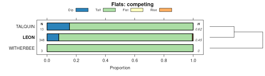
Official Series Description


Lab Data Summary

Aggregate lab data for the LEON soil series. This aggregation is based on all pedons with a current taxon name of LEON, and applied along 1-cm thick depth slices. Solid lines are the slice-wise median, bounded on either side by the interval defined by the slice-wise 5th and 95th percentiles. The median is the value that splits the data in half. Five percent of the data are less than the 5th percentile, and five percent of the data are greater than the 95th percentile. Values along the right hand side y-axis describe the proportion of pedon data that contribute to aggregate values at this depth. For example, a value of "90%" at 25cm means that 90% of the pedons correlated to LEON were used in the calculation. Source: KSSL snapshot . Methods used to assemble the KSSL snapshot used by SoilWeb / SDE

Click the image to view it full size.

Pedons used in the lab summary:

MLRALab IDPedon IDTaxonnameCINSSL / NASIS ReportsLink To SoilWeb GMap
133AS37_0281978-FL073-S37_028Leon3Primary | Supplementary | Taxonomy | Pedon | Water Retention | Correlation | Andic Soil Properties30.3656883,-84.1507034
133AS03_0031979-FL005-S03_003Leon3Primary | Supplementary | Taxonomy | Pedon | Water Retention | Correlation | Andic Soil Properties30.5141315,-85.3931198
138S12_0171980-FL023-S12_017Leon3Primary | Supplementary | Taxonomy | Pedon | Water Retention | Correlation | Andic Soil Properties30.1835079,-82.5927582
152AS57_0461976-FL113-S57_046Leon2Primary | Supplementary | Taxonomy | Pedon | Water Retention | Correlation | Andic Soil Properties30.3878059,-87.0137939
152AS66_0241979-FL131-S66_024Leon3Primary | Supplementary | Taxonomy | Pedon | Water Retention | Correlation | Andic Soil Properties30.3655834,-86.1789246
152AS33_0241981-FL065-S33_024Leon3Primary | Supplementary | Taxonomy | Pedon | Water Retention | Correlation | Andic Soil Properties30.2631435,-83.9103317
152AS46_0021985-FL091-S46_002Leon3Primary | Supplementary | Taxonomy | Pedon | Water Retention | Correlation | Andic Soil Properties30.3973637,-86.4123688
152AS19_0061986-FL037-S19_006Leon3Primary | Supplementary | Taxonomy | Pedon | Water Retention | Correlation | Andic Soil Properties29.9539032,-84.4867477
152AS21_0061986-FL041-S21_006Leon3Primary | Supplementary | Taxonomy | Pedon | Water Retention | Correlation | Andic Soil Properties29.7870388,-82.8115082
152AS62_0061988-FL123-S62_006Leon3Primary | Supplementary | Taxonomy | Pedon | Water Retention | Correlation | Andic Soil Properties29.8666687,-83.4183273
152AS23_0041989-FL045-S23_004Leon3Primary | Supplementary | Taxonomy | Pedon | Water Retention | Correlation | Andic Soil Properties29.7162838,-85.2337112
152AS34_0031989-FL067-S34_003Leon3Primary | Supplementary | Taxonomy | Pedon | Water Retention | Correlation | Andic Soil Properties30.0139828,-83.3021011
152AS15_0051990-FL029-S15_005Leonn/aPrimary | Supplementary | Taxonomy | Pedon | Water Retention | Correlation | Andic Soil Properties29.7536106,-83.0805588
152A89P058089FL045004Leon3Primary | Supplementary | Taxonomy | Pedon | Water Retention | Correlation | Andic Soil Properties29.916666,-85.3333359
152A89P051489FL067003Leon6Primary | Supplementary | Taxonomy | Pedon | Water Retention | Correlation | Andic Soil Properties30.0191669,-83.3113861
153AS02_0011980-FL003-S02_001Leon3Primary | Supplementary | Taxonomy | Pedon | Water Retention | Correlation | Andic Soil Properties30.2547703,-82.0819855
153AS02_0021980-FL003-S02_002Leon3Primary | Supplementary | Taxonomy | Pedon | Water Retention | Correlation | Andic Soil Properties30.2512493,-82.0743256
153AS10_0121984-FL019-S10_012Leon3Primary | Supplementary | Taxonomy | Pedon | Water Retention | Correlation | Andic Soil Properties29.8911839,-81.8536377
153AS45_0271985-FL089-S45_027Leon3Primary | Supplementary | Taxonomy | Pedon | Water Retention | Correlation | Andic Soil Properties30.5964527,-81.9071884
153AS04_0081986-FL007-S04_008Leon3Primary | Supplementary | Taxonomy | Pedon | Water Retention | Correlation | Andic Soil Properties29.8828144,-82.2764435
153AS02_0151989-FL003-S02_015Leon3Primary | Supplementary | Taxonomy | Pedon | Water Retention | Correlation | Andic Soil Properties30.2986145,-82.0809402
153A82P0193S1981SC051008Leon7Primary | Supplementary | Taxonomy | Pedon | Water Retention | Correlation | Andic Soil Properties33.7918015,-79.0164261
153BS16_009S1975-FL031-S16_009Leon3Primary | Supplementary | Taxonomy | Pedon | Water Retention | Correlation | Andic Soil Properties30.4957619,-81.6261749
n/a40A5359S1969NC107001LEON6Primary | Supplementary | Taxonomy | Pedon | Water Retention | Correlation | Andic Soil Propertiesn/a

Water Balance

Monthly water balance estimated using a leaky-bucket style model for the LEON soil series. Monthly precipitation (PPT) and potential evapotranspiration (PET) have been estimated from the 50th percentile of gridded values (PRISM 1981-2010) overlapping with the extent of SSURGO map units containing each series as a major component. Monthly PET values were estimated using the method of Thornthwaite (1948). These (and other) climatic parameters are calculated with each SSURGO refresh and provided by the fetchOSD function of the soilDB package. Representative water storage values (“AWC” in the figures) were derived from SSURGO by taking the 50th percentile of profile-total water storage (sum[awc_r * horizon thickness]) for each soil series. Note that this representation of “water storage” is based on the average ability of most plants to extract soil water between 15 bar (“permanent wilting point”) and 1/3 bar (“field capacity”) matric potential. Soil moisture state can be roughly interpreted as “dry” when storage is depleted, “moist” when storage is between 0mm and AWC, and “wet” when there is a surplus. Clearly there are a lot of assumptions baked into this kind of monthly water balance. This is still a work in progress.

Click the image to view it full size.


Click the image to view it full size.

Sibling Summary

Siblings are those soil series that occur together in map units, in this case with the LEON series. Sketches are arranged according to their subgroup-level taxonomic structure. Source: SSURGO snapshot , parsed OSD records and snapshot of SC database .

Click the image to view it full size.

Select annual climate data summaries for the LEON series and siblings. Series are sorted according to hierarchical clustering of median values. Source: SSURGO map unit geometry and 1981-2010, 800m PRISM data .

Click the image to view it full size.

Geomorphic description summaries for the LEON series and siblings. Series are sorted according to hierarchical clustering of proportions and relative hydrologic position within an idealized landform (e.g. top to bottom). Most soil series (SSURGO components) are associated with a hillslope position and one or more landform-specific positions: hills, mountain slopes, terraces, and/or flats. Proportions can be interpreted as an aggregate representation of geomorphic membership. The values printed to the left (number of component records) and right (Shannon entropy) of stacked bars can be used to judge the reliability of trends. Small Shannon entropy values suggest relatively consistent geomorphic association, while larger values suggest lack thereof. Source: SSURGO component records .

Click the image to view it full size.

Click the image to view it full size.

There are insufficient data to create the 3D mountains figure.

Click the image to view it full size.

Click the image to view it full size.

Competing Series

Soil series competing with LEON share the same family level classification in Soil Taxonomy. Source: parsed OSD records and snapshot of the SC database .

Click the image to view it full size.

Select annual climate data summaries for the LEON series and competing. Series are sorted according to hierarchical clustering of median values. Source: SSURGO map unit geometry and 1981-2010, 800m PRISM data .

Click the image to view it full size.

Geomorphic description summaries for the LEON series and competing. Series are sorted according to hierarchical clustering of proportions and relative hydrologic position within an idealized landform (e.g. top to bottom). Proportions can be interpreted as an aggregate representation of geomorphic membership. Most soil series (SSURGO components) are associated with a hillslope position and one or more landform-specific positions: hills, mountain slopes, terraces, and/or flats. The values printed to the left (number of component records) and right (Shannon entropy) of stacked bars can be used to judge the reliability of trends. Shannon entropy values close to 0 represent soil series with relatively consistent geomorphic association, while values close to 1 suggest lack thereof. Source: SSURGO component records .

There are insufficient data to create the 2D hillslope position figure.

There are insufficient data to create the 3D hills figure.

There are insufficient data to create the 3D mountains figure.

Click the image to view it full size.

Click the image to view it full size.

Soil series sharing subgroup-level classification with LEON, arranged according to family differentiae. Hovering over a series name will print full classification and a small sketch from the OSD. Source: snapshot of SC database .

Block Diagrams

Click a link below to display the diagram. Note that these diagrams may be from multiple survey areas.

  1. FL-2011-05-31-08 | City of Jacksonville, Duval County - 1978

    Typical pattern of soils and parent material in an area of the Fripp-Corolla-Mandarin, Cornelia-Mandarin-Leon, and Tisonia-Maurepas general soil map units. The soils of these map units support native vegetation (Soil Survey of City of Jacksonville, Duval County, Florida; 1978).

  2. FL-2011-05-31-09 | City of Jacksonville, Duval County - 1978

    Typical pattern of soils and parent material in an area of the Leon-Hurricane/Ridgewood-Ortega general soil map unit. This map unit is dominantly used for urban development (Soil Survey of City of Jacksonville, Duval County, Florida; 1978).

  3. FL-2011-05-31-10 | City of Jacksonville, Duval County - 1978

    Typical pattern of soils and parent material in an area of the Leon-Boulogne-Evergreen/Wesconnett general soil map unit. Soils of this map unit are dominantly used for the production of pine trees. In the eastern part of the county, many areas are used for urban development (Soil Survey of City of Jacksonville, Duval County, Florida; 1978).

  4. FL-2011-05-31-12 | Nassau County - 1991

    Typical pattern of soils and parent material in an area of the Kureb-Fripp-Newhan and Mandarin-Echaw map units (Soil Survey of Nassau County, Florida; 1991).

  5. FL-2011-05-31-13 | Nassau County - 1991

    Typical pattern of soils and parent material in an area of the Albany-Blanton-Penny and Osler-Ousley-Mandarin map units (Soil Survey of Nassau County, Florida; 1991).

  6. FL-2011-05-31-14 | Nassau County - 1991

    Typical pattern of soils and parent material in an area of the Leon-Boulogne-Kingsferry map unit (Soil Survey of Nassau County, Florida; 1991).

  7. FL-2011-05-31-16 | Suwannee County - 1965

    Marine terraces in Suwannee County, and the position of some of the soils (Soil Survye of Suwannee County, Florida; 1965).

  8. FL-2012-04-26-09 | Seminole County - June 1966

    Cross section of Seminole County showing the relationship between the geologic strata and artesian and nonartesian water, and the relative position of some of the sandy soils to the ground water table (Soil Survey of Seminole County, Florida; June 1966).

  9. FL-2012-04-26-27 | Washington County - May 1965

    Geologic formations of Washington County and the position of most soil series (Soil Survey of Washington County, Florida; May 1965).

  10. NC-2012-02-07-04 | Carteret County - September 1987

    Landscape position and seasonal high water table relationships are illustrated in uplands where the soils are sandy (Soil Survey of Carteret County, North Carolina; September 1987).

  11. NC-2012-02-07-10 | Craven County - March 1989

    The soils on stream terraces and flood plains formed in sandy and loamy sediment and in organic material. Natural drainage is related to landscaped position (Soil Survey of Craven County, North Carolina; March 1989).

Map Units

Map units containing LEON as a major component. Limited to 250 records.

Map Unit Name Symbol Map Unit Area (ac) Map Unit Key National Map Unit Symbol Soil Survey Area Publication Date Map Scale
Leon sandLs4564328164c0gyal00319611:20000
St. Lucie-Leon-Muck complexSt3403328209c0jdal00319611:20000
Leon sand, 0 to 2 percent slopes232319514448812sxqqfl00319911:20000
Leon-Evergreen complex, depressional24309514448821khj3fl00319911:20000
Leon fine sand, occasionally flooded5126514449081khjyfl00319911:20000
Leon sand, 0 to 2 percent slopes13399153208012rz0sfl00519821:20000
Leon sand, 0 to 2 percent slopes1939496316312sxqqfl00719881:15840
Leon fine sand, 0 to 2 percent slopes9431001328542sxqvfl01919861:24000
Leon fine sand, frequently flooded5020501328384g73fl01919861:24000
Leon fine sand, 0 to 2 percent slopes3253407974532sxqvfl02319811:24000
Leon fine sand, occasionally flooded33680797454vrtbfl02319811:24000
Leon-Leon, depressional complex175173514210871jprjfl02919981:24000
Chaires, limestone substratum-Leon complex203132014210911jprnfl02919981:24000
Leon mucky fine sand, frequently flooded15100014210851jprgfl02919981:24000
Ousley-Leon-Clara complex, 0 to 3 percent slopes, occasionally flooded6414914210781jpr7fl02919981:24000
Leon fine sand, 0 to 2 percent slopes32712007388442sxqvfl03119961:24000
Urban land-Leon-Boulogne complex, 0 to 2 percent slopes7121440738883ssvyfl03119961:24000
Leon fine sand, 0 to 2 percent slopes, very frequently flooded33500738845sstqfl03119961:24000
Leon sand, 0 to 2 percent slopes9446014253172rz0sfl03319981:24000
Leon sand, 0 to 2 percent slopes222466814770742rz0sfl03719901:20000
Chipley, Leon, and Foxworth soils, 0 to 5 percent slopes78181313816171hcp9fl03920061:12000
Leon-Chipley complex33146913815731hcmwfl03920061:12000
Leon, Clara, and Pickney soils, commonly flooded86127413816251hcpkfl03920061:12000
Plummer-Leon-Sapelo complex10686914721291ldw1fl03920061:12000
Bonifay-Leon-Chipley complex, 0 to 5 percent slopes8535813816241hcpjfl03920061:12000
Leon fine sand, 0 to 2 percent slopes780103218202tsy0fl04119891:20000
Leon fine sand, frequently flooded272070321809bsvyfl04119891:20000
Leon fine sand, 0 to 2 percent slopes221213714727432tsy0fl04519971:24000
Leon fine sand95750700472rhwwfl06519841:20000
Leon-Chaires fine sands541150700508rhy1fl06519841:20000
Leon fine sand, 0 to 2 percent slopes14362008865692tsy0fl06719931:24000
Leon fine sand, 0 to 2 percent slopes472047014544572tsy0fl07319891:20000
Leon sand23788014544311ktg4fl07319891:20000
Hurricane, Leon, and Albany soils4616355322735btttfl07720041:24000
Leon sand, 0 to 2 percent slopes3982203227272rz0sfl07720041:24000
Leon-Chipley complex98516727851t4ntfl07720041:24000
Leon fine sand, 0 to 2 percent slopes9375851329512sxqvfl08919891:15840
Evergreen-Leon mucks, depressional39159101329274g9zfl08919891:15840
Sapelo-Leon fine sand22125751329094g9dfl08919891:15840
Lynn Haven-Wesconnett-Leon complex, depressional188851329044g97fl08919891:15840
Leon fine sand, tidal198201329054g98fl08919891:15840
Leon sand, 0 to 2 percent slopes15284014446972rz0sfl09119891:20000
Leon sand, 0 to 2 percent slopes2455608237712rz0sfl11319781:24000
Leon fine sand321078102334613bw5fl12120031:24000
Leon fine sand, 0 to 2 percent slopes66908014252002tsy0fl12319981:24000
Leon mucky fine sand58699514252601jv34fl12319981:24000
Leon fine sand, rarely flooded71379014252731jv3kfl12319981:24000
Ousley-Leon-Clara complex, 0 to 3 percent slopes, occasionally flooded17275514252111jv1kfl12319981:24000
Leon sand, 0 to 2 percent slopes232830013990492rz0sfl12919881:24000
Leon sand, 0 to 2 percent slopes21131303239912rz0sfl13119851:20000
Albany, Chipley, Leon complex, 0 to 5 percent slopes9484023984622lhsrfl13320091:12000
Leon-Chipley complex10047423984912lhtpfl13320091:12000
Leon sand, 0 to 2 percent slopesLrA20853245462sxqqga03119651:20000
Leon sand, 0 to 2 percent slopesLnA1334017011032sxqqga10320071:24000
Leon fine sand, 0 to 2 percent slopesLrA182251246362sxqvga19119601:20000
Leon fine sand, 0 to 2 percent slopesLeA701524083612sxqtga29920081:24000
Leon fine sand, frequently ponded, 0 to 2 percent slopesLoA368024083622sxqpga29920081:24000
Leon sand, 0 to 2 percent slopesLrA408351250902sxqqga30519621:20000
Leon fine sand, 0 to 2 percent slopesLeA10116026867822sxqtga61120121:24000
Leon fine sand, frequently ponded, 0 to 2 percent slopesLoA263526867582sxqpga61120121:24000
Leon fine sand, 0 to 2 percent slopesLr98801253852sxqvga61319691:20000
Leon fine sand, 0 to 2 percent slopesLeA22426868072sxqtga62620131:24000
Leon mucky sand, 0 to 1 percent slopes85250332605c536ms05919971:24000
Leon sandLo53921115823r3fnc01319861:24000
Leon sand, 0 to 3 percent slopesLeA366051154983w5rnc01719831:24000
Leon fine sandLo496361155443w77nc01919831:24000
Leon sandLn202851156013w92nc03119841:24000
Leon-Urban land complexLu2931156023w93nc03119841:24000
Leon sand, 1 to 4 percent slopesLnB79301156513wbpnc04719861:24000
Leon sandLn59641157593wg5nc04919841:24000
Leon sandLe6615811122w717nc05119811:24000
Leon fine sand, 0 to 2 percent slopes, rarely floodedLeA3391109843qh4nc05519871:24000
Leon sand, 0 to 2 percent slopesLnA25443186597420mpqnc06119551:24000
Leon sand, 0 to 2 percent slopesLoA15931159393wmznc07319901:24000
Leon sandLe50811291w76pnc09319811:24000
Leon sandLn55521159753wp4nc10319791:24000
Leon sandLo41301160093wq7nc10719731:20000
Leon sandLe127961160433wrbnc12919741:15840
Leon-Urban land complexLo10741160443wrcnc12919741:15840
Leon fine sandLn315271160853wspnc13319841:24000
Leon sandLn55891161363wvbnc13719841:24000
Leon fine sand, 0 to 2 percent slopesLnA304511161753wwlnc14119861:24000
Leon sandLe25561147713vf9nc15519721:20000
Leon sand, 0 to 2 percent slopesLeA144271150563vqhnc16319821:24000
Leon sandLn21591162473wyxnc19119681:20000
Leon fine sand, 0 to 2 percent slopesLo79841324102sxqtsc01319751:20000
Fripp-Baratari complexFb78371324224fspsc01319751:20000
Leon fine sand, 0 to 2 percent slopesLo25251319582sxqtsc01519741:20000
Leon sand, 0 to 2 percent slopes4038801322752sxqrsc02919801:20000
Fripp-Leon complex, 0 to 6 percent slopes9B5851323044fnwsc02919801:20000
Leon sand, 0 to 2 percent slopesLeA242619115ns7gsc03119981:24000
Leon sand, 0 to 2 percent slopesLbA27801297564c0psc03319761:20000
Leon sand, 0 to 2 percent slopesLe23001298112sxqrsc03519851:20000
Leon sand, 0 to 2 percent slopes10189606395702sxqrsc04319801:20000
Leon sand, 0 to 2 percent slopesLe10331301102sxqrsc04919901:20000
Leon fine sandLe361271301534cfhsc05119831:20000
Leon fine sand, 0 to 2 percent slopesLo841325302sxqtsc05319751:20000
Fripp-Baratari complexFb791325514fxvsc05319751:20000
Leon sandLe25001305724cw0sc06719751:20000
Leon sandLe3731306404cy6sc06919951:24000
Leon sand, 0 to 2 percent slopesLe31131315292sxqrsc08919851:20000
Leon fine sand, 0 to 2 percent slopesLe95951382832sxqtsc69019671:24000
Leon-Chipley sands8790119332405fva09319821:15840
Chipley-Leon complex, 0 to 2 percent slopes9A104812248943g8va18119971:24000
Chipley-Leon complex, 2 to 5 percent slopes9B69912249243gcva18119971:24000

Map of Series Extent

Approximate geographic distribution of the LEON soil series. To learn more about how this distribution was mapped, or to compare this soil series extent to others, use the Series Extent Explorer (SEE) application. Source: generalization of SSURGO geometry .