| Leafriver muck | 19 | 3660 | 190250 | 6cz3 | mi001 | 1993 | 1:20000 |
Leafriver-Wakeley complex | 273 | 2097 | 190302 | 6d0s | mi001 | 1993 | 1:20000 |
Deford and Leafriver soils, 0 to 2 percent slopes | 19 | 752 | 1455254 | 2xxj3 | mi003 | 2007 | 1:24000 |
Leafriver muck | 19 | 33 | 191262 | 6f0r | mi007 | 1998 | 1:12000 |
Tawas-Leafriver mucks, 0 to 1 percent slopes | TawleA | 3276 | 3155943 | 2ythr | mi009 | 1976 | 1:15840 |
Leafriver muck, 0 to 1 percent slopes | LfraaA | 178 | 3155932 | 2ythd | mi009 | 1976 | 1:15840 |
Gay-Leafriver complex, 0 to 2 percent slopes | 8125 | 303 | 2441895 | 2myzt | mi013 | 1984 | 1:20000 |
Deford and Leafriver soils, 0 to 2 percent slopes | 8114 | 181 | 2441894 | 2xxj3 | mi013 | 1984 | 1:20000 |
Tawas-Leafriver mucks, 0 to 1 percent slopes | TawleA | 41 | 3187035 | 2ythr | mi029 | 1970 | 1:15840 |
Deford and Leafriver soils, 0 to 2 percent slopes | 50 | 10534 | 415159 | 2xxj3 | mi033 | 1989 | 1:15840 |
Tawas-Leafriver mucks | 51 | 8071 | 189723 | 6cf3 | mi039 | 1993 | 1:15840 |
Leafriver muck | 19 | 3210 | 189663 | 6cc5 | mi039 | 1993 | 1:15840 |
Wakeley-Leafriver complex | 275 | 332 | 189706 | 6cdk | mi039 | 1993 | 1:15840 |
Deford and Leafriver soils, 0 to 2 percent slopes | Dm | 670 | 1588042 | 2xxj3 | mi041 | 1969 | 1:24000 |
Deford and Leafriver soils, 0 to 2 percent slopes | 26 | 4348 | 415212 | 2xxj3 | mi043 | 1985 | 1:20000 |
Cathro-Leafriver complex, 0 to 1 percent slopes, frequently flooded | 688 | 547 | 1456343 | 1kwft | mi053 | 2007 | 1:24000 |
Deford and Leafriver soils, 0 to 2 percent slopes | 650 | 276 | 1456226 | 2xxj3 | mi053 | 2007 | 1:24000 |
Minocqua-Leafriver complex, 0 to 1 percent slopes | 21 | 12 | 1456364 | 1kwgh | mi053 | 2007 | 1:24000 |
Deford and Leafriver soils, 0 to 2 percent slopes | 67 | 2168 | 416151 | 2xxj3 | mi061 | 1989 | 1:20000 |
Gay-Leafriver complex, 0 to 2 percent slopes | 8125 | 715 | 2483706 | 2pchk | mi061 | 1989 | 1:20000 |
Leafriver muck | 19 | 2494 | 191725 | 6fhp | mi069 | 1995 | 1:15840 |
Proper-Leafriver complex, 0 to 6 percent slopes | 372B | 800 | 191835 | 6fm7 | mi069 | 1995 | 1:15840 |
Leafriver-Wakeley complex | 273 | 618 | 191811 | 6flg | mi069 | 1995 | 1:15840 |
Minocqua-Leafriver complex, 0 to 1 percent slopes | 21 | 3556 | 2452460 | 2n9zm | mi071 | 1992 | 1:20000 |
Tawas-Leafriver mucks | 51 | 10331 | 190663 | 6ddf | mi079 | 1998 | 1:12000 |
Leafriver muck | 19 | 1282 | 190634 | 6dch | mi079 | 1998 | 1:12000 |
Deford and Leafriver soils, 0 to 2 percent slopes | 23 | 1084 | 627467 | 2xxj3 | mi095 | 2004 | 1:24000 |
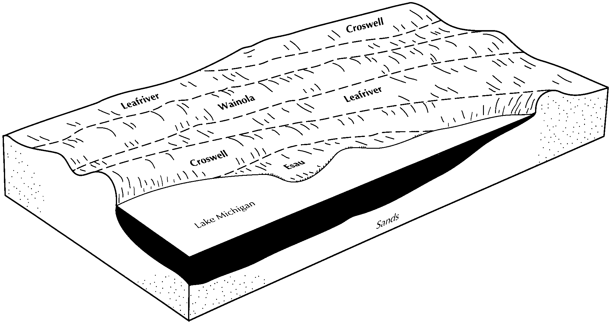
Leafriver-Croswell-Wainola complex, 0 to 6 percent slopes | 172B | 15854 | 416349 | fz7m | mi097 | 1994 | 1:20000 |
Deford and Leafriver soils, 0 to 2 percent slopes | 23 | 12540 | 416379 | 2xxj3 | mi097 | 1994 | 1:20000 |
Eastport-Leafriver complex, 0 to 35 percent slopes | 38E | 10503 | 416398 | fz96 | mi097 | 1994 | 1:20000 |
Wainola-Leafriver-Pullup complex, 0 to 35 percent slopes | 48E | 2446 | 416408 | fz9j | mi097 | 1994 | 1:20000 |
Deford and Leafriver soils, 0 to 2 percent slopes | 19 | 2466 | 395146 | 2xxj3 | mi103 | 1999 | 1:24000 |
Deford and Leafriver soils, 0 to 2 percent slopes | 21 | 9067 | 415459 | 2xxj3 | mi109 | 1985 | 1:20000 |
Deford and Leafriver soils, 0 to 2 percent slopes | 30A | 709 | 1456409 | 2xxj3 | mi131 | 2007 | 1:24000 |
Tawas-Leafriver mucks | 51 | 3004 | 241391 | 835t | mi135 | 2003 | 1:12000 |
Leafriver-Wakeley complex | 273 | 671 | 241477 | 838l | mi135 | 2003 | 1:12000 |
Leafriver muck | 19 | 235 | 241382 | 835j | mi135 | 2003 | 1:12000 |
Tawas-Leafriver mucks | 51 | 2888 | 191505 | 6f8l | mi137 | 1998 | 1:12000 |
Leafriver muck | 19 | 449 | 191457 | 6f71 | mi137 | 1998 | 1:12000 |
Tawas-Leafriver mucks | 51 | 10202 | 191030 | 6ds8 | mi143 | 1999 | 1:12000 |
Deford and Leafriver soils, 0 to 2 percent slopes | 63 | 24016 | 1456948 | 2xxj3 | mi153 | 2007 | 1:24000 |
Tawas-Leafriver complex, 0 to 4 percent slopes | 42 | 403 | 2378185 | 2ktpn | mi606 | | 1:12000 |
Leafriver muck | 1984 | 8825 | 432879 | gjfv | mn001 | 1996 | 1:20000 |
Forada and Leafriver soils, frequently ponded, 0 to 1 percent slopes | 1942 | 1293 | 397497 | 2w0mh | mn005 | 1994 | 1:20000 |
Deford-Leafriver complex, 0 to 2 percent slopes | B76A | 459 | 2653434 | sfxv | mn007 | 1991 | 1:24000 |
Leafriver, frequently flooded and Minocqua soils, 0 to 2 percent slopes, ponded | C185A | 528 | 3462673 | 31rs6 | mn065 | 2006 | 1:12000 |
Leafriver-Minocqua-Dora complex, 0 to 2 percent slopes, ponded | C184A | 442 | 3462674 | 31rrw | mn065 | 2006 | 1:12000 |
Leafriver muck | 1984 | 30494 | 398872 | fd1v | mn077 | 1989 | 1:24000 |
Forada and Leafriver soils, frequently ponded, 0 to 1 percent slopes | 1077 | 11433 | 435522 | 2w0mh | mn111 | 1996 | 1:20000 |
Minocqua-Leafriver-Cathro, 0 to 2 percent slopes, ponded | C39A | 19460 | 3314091 | 308xg | mn115 | 2009 | 1:24000 |
Cathro, Seelyeville, and Leafriver soils, 0 to 1 percent slopes, ponded | C33A | 5755 | 3314094 | 308xl | mn115 | 2009 | 1:24000 |
Leafriver-Minocqua-Dora complex, 0 to 2 percent slopes, ponded | C184A | 1520 | 3462634 | 31rrw | mn115 | 2009 | 1:24000 |
Leafriver, frequently flooded and Minocqua soils, 0 to 2 percent slopes, ponded | C185A | 555 | 3462644 | 31rs6 | mn115 | 2009 | 1:24000 |
Newson and Leafriver soils, 0 to 1 percent slopes, frequently ponded | C280A | 89 | 3462727 | 31116 | mn115 | 2009 | 1:24000 |
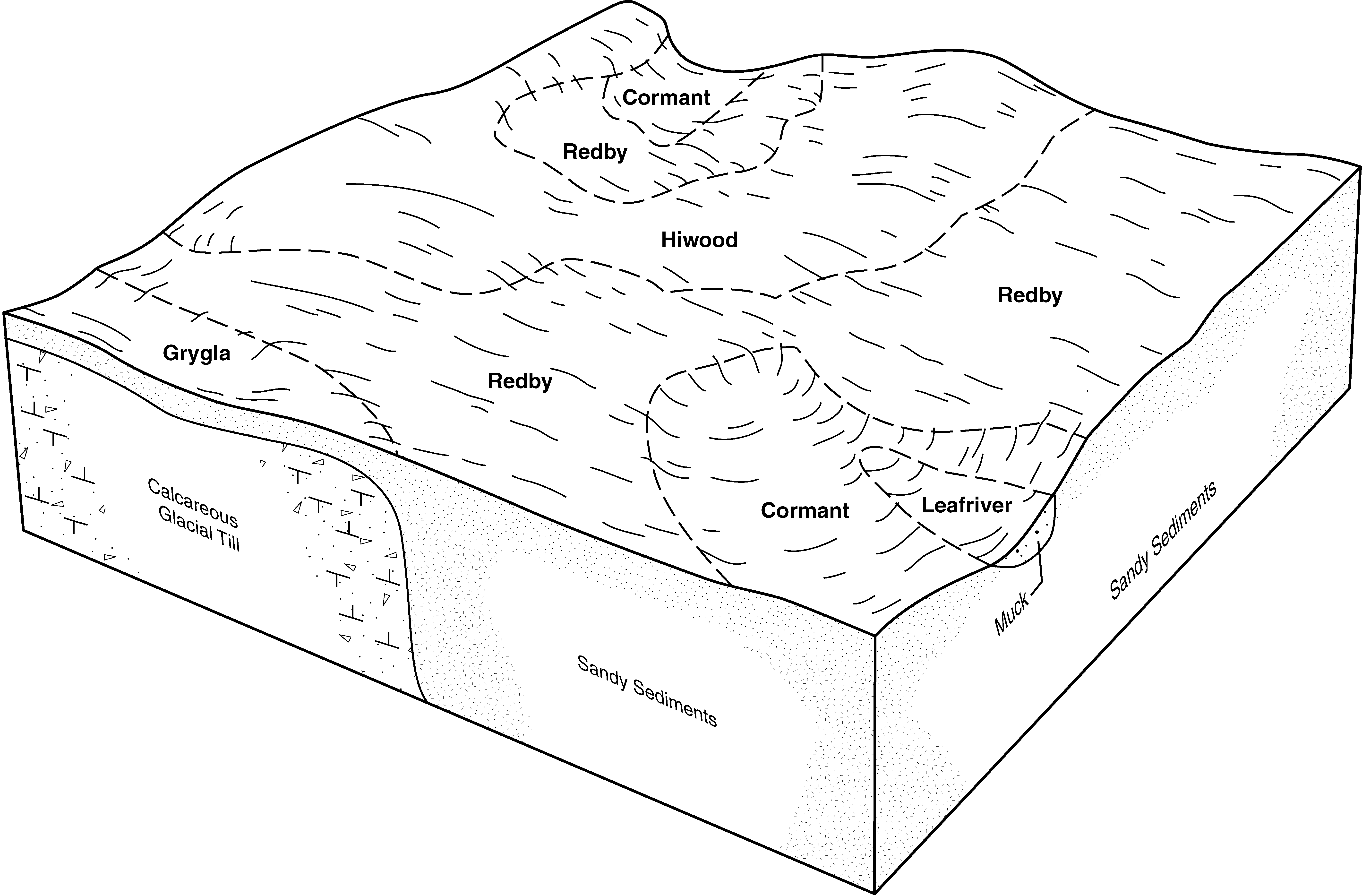
Redby-Hiwood-Leafriver complex, 0 to 6 percent slopes | 1274B | 16072 | 394798 | f7tf | mn135 | 1999 | 1:24000 |
Leafriver muck, 0 to 1 percent slopes | 1984 | 7140 | 394831 | f7vh | mn135 | 1999 | 1:24000 |
Leafriver muck, wooded, 0 to 1 percent slopes | 1402 | 5674 | 394814 | f7ty | mn135 | 1999 | 1:24000 |
Leafriver muck | 1984 | 12255 | 428782 | gd5p | mn159 | 1987 | 1:20000 |
Forada and Leafriver soils, frequently ponded, 0 to 1 percent slopes | 1942 | 4474 | 428774 | 2w0mh | mn159 | 1987 | 1:20000 |
Forada and Leafriver soils, frequently ponded, 0 to 1 percent slopes | 1942 | 536 | 435091 | 2w0mh | mn171 | 1998 | 1:12000 |
Leafriver-Deford, depressional-Markey complex, 0 to 1 percent slopes | B71A | 23366 | 2943770 | sfxs | mn625 | 2015 | 1:24000 |
Deford-Leafriver complex, 0 to 2 percent slopes | B76A | 20181 | 2943771 | sfxv | mn625 | 2015 | 1:24000 |
Leafriver-Cormant-Markey complex, 0 to 1 percent slopes | B247A | 561 | 2943793 | 2dv52 | mn625 | 2015 | 1:24000 |
Cormant-Leafriver complex, 0 to 1 percent slopes | B249A | 237 | 2943795 | 2dv54 | mn625 | 2015 | 1:24000 |
Minocqua-Leafriver-Cathro, 0 to 2 percent slopes, ponded | 6139A | 168 | 3314106 | 308xg | wi013 | 2004 | 1:12000 |
Cathro, Seelyeville, and Leafriver soils, 0 to 1 percent slopes, ponded | 6033A | 7 | 3314109 | 308xl | wi013 | 2004 | 1:12000 |
Minocqua-Leafriver-Cathro, 0 to 2 percent slopes, ponded | 6139A | 7709 | 3314118 | 308xg | wi031 | 2005 | 1:12000 |
Cathro, Seelyeville, and Leafriver soils, 0 to 1 percent slopes, ponded | 6033A | 2502 | 3314121 | 308xl | wi031 | 2005 | 1:12000 |
Deford and Leafriver soils, 0 to 2 percent slopes | 3919A | 18693 | 3119048 | 2xxj3 | wi075 | 1987 | 1:20000 |
Deford and Leafriver soils, 0 to 2 percent slopes | 3919A | 1538 | 395855 | 2xxj3 | wi078 | 1998 | 1:12000 |
Deford and Leafriver soils, 0 to 2 percent slopes | 3919A | 4099 | 3119053 | 2xxj3 | wi083 | 1985 | 1:15840 |
Deford and Leafriver soils, 0 to 2 percent slopes | 3919A | 1336 | 3119058 | 2xxj3 | wi115 | 1981 | 1:15840 |