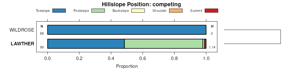
| Lawther silty clay, 2 to 4 percent slopes | 146 | 7936 | 342375 | ch8c | mt027 | 1979 | 1:24000 |
Eltsac-Lawther clays, 2 to 8 percent slopes | 79 | 7871 | 342582 | chh1 | mt027 | 1979 | 1:24000 |
Lawther silty clay, 0 to 2 percent slopes | 145 | 7507 | 342374 | ch8b | mt027 | 1979 | 1:24000 |
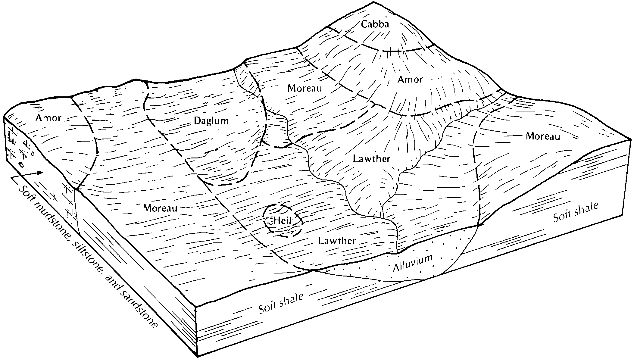
Lawther clay, 0 to 4 percent slopes | 54B | 3487 | 344225 | ck61 | mt051 | 1992 | 1:24000 |
Lawther clay, 4 to 8 percent slopes | 54C | 834 | 344226 | ck62 | mt051 | 1992 | 1:24000 |
Gerber-Lawther silty clays, 4 to 8 percent slopes | 88 | 10879 | 341976 | cgvh | mt613 | 1975 | 1:24000 |
Lawther silty clay, 0 to 4 percent slopes | 122 | 10853 | 341782 | cgn7 | mt613 | 1975 | 1:24000 |
Lawther clay | 123 | 2497 | 341783 | cgn8 | mt613 | 1975 | 1:24000 |
Lawther-Gerber complex, 8 to 15 percent slopes | 124 | 2373 | 341784 | cgn9 | mt613 | 1975 | 1:24000 |
Gerber-Lawther silty clays, 0 to 4 percent slopes | 87 | 2198 | 341975 | cgvg | mt613 | 1975 | 1:24000 |
Lawther silty clay, 0 to 2 percent slopes | E0821A | 3725 | 2525726 | 1vzs6 | nd001 | 1983 | 1:20000 |
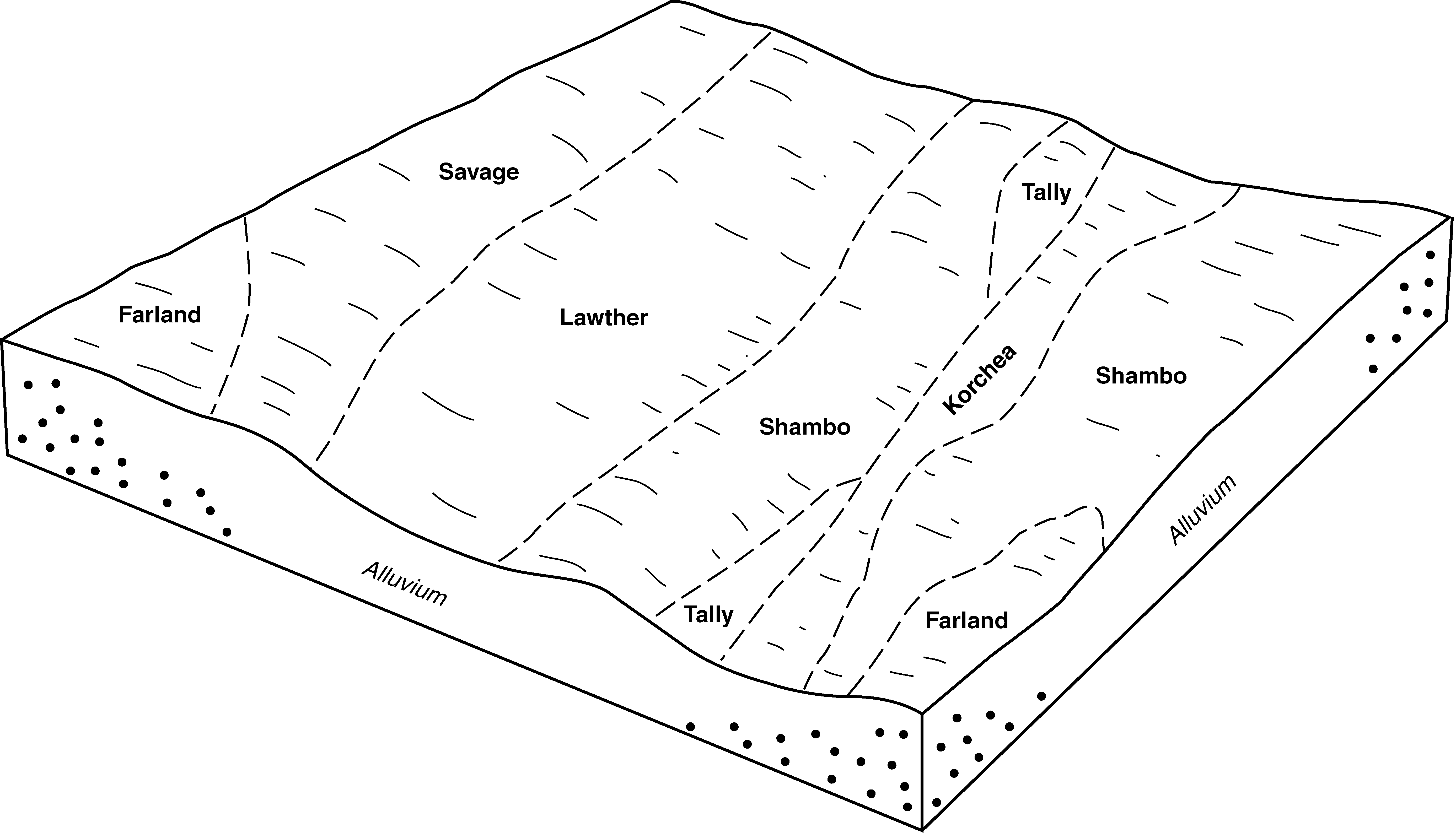
Lawther-Daglum complex, 0 to 2 percent slopes | E0634A | 2481 | 2563574 | 1vzrq | nd011 | 1969 | 1:20000 |
Lawther silty clay, 0 to 2 percent slopes | E0821A | 814 | 2563573 | 1vzs6 | nd011 | 1969 | 1:20000 |
Lawther silty clay, 0 to 2 percent slopes | La | 7 | 992851 | 12b4g | nd011 | 1969 | 1:20000 |
Lawther silty clay, 0 to 2 percent slopes | E0821A | 5443 | 2707185 | 1vzs6 | nd025 | 1981 | 1:20000 |
Lawther silty clay, 2 to 6 percent slopes | E0821B | 962 | 2707186 | 1vzs7 | nd025 | 1981 | 1:20000 |
Lawther-Daglum complex, 2 to 6 percent slopes | E0634B | 46 | 1713159 | 1vzrr | nd025 | 1981 | 1:20000 |
Lawther-Daglum complex, 0 to 2 percent slopes | E0634A | 11 | 1713158 | 1vzrq | nd025 | 1981 | 1:20000 |
Lawther silty clay, 0 to 2 percent slopes | E0821A | 1351 | 2707277 | 1vzs6 | nd033 | 1985 | 1:24000 |
Lawther silty clay, 2 to 6 percent slopes | E0821B | 1130 | 2707278 | 1vzs7 | nd033 | 1985 | 1:24000 |
Lawther silty clay, 0 to 2 percent slopes | E0821A | 2257 | 2525860 | 1vzs6 | nd037 | 1985 | 1:20000 |
Lawther silty clay, 0 to 2 percent slopes | E0821A | 9836 | 1718583 | 1vzs6 | nd041 | 1986 | 1:20000 |
Lawther-Daglum complex, 0 to 2 percent slopes | E0634A | 41 | 1718578 | 1vzrq | nd041 | 1986 | 1:20000 |
Lawther silty clay, 2 to 6 percent slopes | E0821B | 15 | 1718584 | 1vzs7 | nd041 | 1986 | 1:20000 |
Lawther silty clay, 0 to 2 percent slopes | E0821A | 10568 | 2715040 | 1vzs6 | nd053 | 2003 | 1:24000 |
Lawther silty clay, 0 to 2 percent slopes | E0821A | 1994 | 2699277 | 1vzs6 | nd057 | 1976 | 1:20000 |
Lawther silty clay, 0 to 2 percent slopes | E0821A | 807 | 2699177 | 1vzs6 | nd059 | 1998 | 1:20000 |
Lawther silty clay, 2 to 6 percent slopes | E0821B | 15 | 1718338 | 1vzs7 | nd059 | 1998 | 1:20000 |
Lawther silty clay, 2 to 6 percent slopes | E0821B | 632 | 2525913 | 1vzs7 | nd065 | 1971 | 1:20000 |
Lawther silty clay, 0 to 2 percent slopes | E0821A | 367 | 2525912 | 1vzs6 | nd065 | 1971 | 1:20000 |
Lawther silty clay, 0 to 2 percent slopes | E0821A | 4 | 2759698 | 1vzs6 | nd085 | 1992 | 1:24000 |
Lawther silty clay, 0 to 2 percent slopes | E0821A | 3365 | 2707384 | 1vzs6 | nd087 | 1974 | 1:20000 |
Lawther-Daglum complex, 0 to 2 percent slopes | E0634A | 2058 | 2707372 | 1vzrq | nd087 | 1974 | 1:20000 |
Lawther clay, sandy substratum, 0 to 2 percent slopes | E0820A | 971 | 2707381 | 2q391 | nd087 | 1974 | 1:20000 |
Lawther silty clay, 2 to 6 percent slopes | E0821B | 613 | 2707385 | 1vzs7 | nd087 | 1974 | 1:20000 |
Lawther clay, sandy substratum, 2 to 6 percent slopes | E0820B | 339 | 2707382 | 2qz8z | nd087 | 1974 | 1:20000 |
Lawther clay, sandy substratum, 6 to 9 percent slopes | E0820C | 151 | 2707383 | 2q392 | nd087 | 1974 | 1:20000 |
Lawther-Daglum complex, 2 to 6 percent slopes | E0634B | 4465 | 1713466 | 1vzrr | nd089 | 1965 | 1:20000 |
Lawther-Daglum complex, 0 to 2 percent slopes | E0634A | 3275 | 1713465 | 1vzrq | nd089 | 1965 | 1:20000 |
Lawther silty clay, 0 to 2 percent slopes | E0821A | 3111 | 1713480 | 1vzs6 | nd089 | 1965 | 1:20000 |
Lawther silty clay, 2 to 6 percent slopes | E0821B | 2889 | 1713481 | 1vzs7 | nd089 | 1965 | 1:20000 |
Lawther silty clay, 0 to 2 percent slopes | E0821A | 3309 | 2662558 | 1vzs6 | nd105 | 1993 | 1:24000 |
Lawther silty clay, 0 to 2 percent slopes | 2349 | 623 | 339060 | cctf | nd105 | 1993 | 1:24000 |
Lawther silty clay, 0 to 2 percent slopes | C476A | 471 | 2567034 | 2q6lb | nd105 | 1993 | 1:24000 |
Lawther silty clay, 3 to 6 percent slopes | LaB | 5962 | 354633 | 2yntn | sd105 | 1977 | 1:24000 |
Lawther silty clay, 0 to 3 percent slopes | LaA | 2470 | 354632 | 2yntm | sd105 | 1977 | 1:24000 |
Lawther silty clay, 6 to 9 percent slopes | LaC | 691 | 354634 | 2yntp | sd105 | 1977 | 1:24000 |
Lawther silty clay, 3 to 6 percent slopes | LaB | 32550 | 355448 | 2yntn | sd601 | 1983 | 1:24000 |


