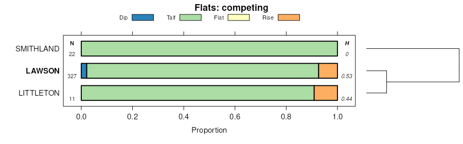
| Lawson silt loam, 0 to 2 percent slopes | 484 | 1688 | 402451 | fhs9 | ia005 | 1992 | 1:15840 |
Lawson-Ossian complex, 0 to 4 percent slopes | 1489B | 19 | 2479294 | 2p6x7 | ia037 | 1989 | 1:15840 |
Nodaway-Lawson silt loams, heavy till, 0 to 2 percent slopes, occasionally flooded | 715 | 3606 | 3004691 | 2xjd7 | ia039 | 1987 | 1:15840 |
Nodaway-Lawson silt loams, 0 to 2 percent slopes, occasionally flooded | 737 | 1418 | 3046378 | 2xbm8 | ia039 | 1987 | 1:15840 |
Lawson silt loam, heavy till, 0 to 2 percent slopes, occasionally flooded | S484 | 1150 | 2983396 | 2wbdk | ia039 | 1987 | 1:15840 |
Lawson silt loam, 0 to 2 percent slopes | 484 | 783 | 404150 | fkk3 | ia039 | 1987 | 1:15840 |
Nodaway-Lawson-Ackmore silt loams, 0 to 2 percent slopes | 1715 | 12590 | 404653 | fl2b | ia051 | 1988 | 1:15840 |
Lawson silt loam, heavy till, 0 to 2 percent slopes, occasionally flooded | 484 | 800 | 404697 | 2wbdk | ia051 | 1988 | 1:15840 |
Nodaway-Lawson-Klum complex, 0 to 3 percent slopes, occasionally flooded | 715 | 17605 | 3004689 | 2xjd6 | ia053 | 1986 | 1:15840 |
Lawson silt loam, heavy till, 0 to 2 percent slopes, occasionally flooded | 484 | 1897 | 404810 | 2wbdk | ia053 | 1986 | 1:15840 |
Lawson silt loam, 0 to 2 percent slopes, occasionally flooded | 484 | 2289 | 405252 | 2yvk0 | ia057 | 1980 | 1:15840 |
Lawson silt loam, frequently flooded, 0 to 2 percent slopes | 2484 | 875 | 405232 | flp0 | ia057 | 1980 | 1:15840 |
Lawson-Huntsville silt loams, 0 to 2 percent slopes | 97 | 480 | 405490 | flyb | ia061 | 1983 | 1:15840 |
Lawson silt loam, 0 to 2 percent slopes, occasionally flooded | 484 | 575 | 406311 | 2yvk0 | ia075 | 1973 | 1:15840 |
Lawson silt loam, heavy till, 0 to 2 percent slopes, occasionally flooded | 484 | 330 | 406864 | 2wbdk | ia087 | 1982 | 1:15840 |
Amana-Nodaway-Lawson complex, 0 to 2 percent slopes, occasionally flooded | 2422 | 2819 | 1144373 | 17dt8 | ia095 | 2005 | 1:12000 |
Lawson silt loam, 0 to 2 percent slopes, occasionally flooded | 484 | 568 | 452971 | 2yvk0 | ia095 | 2005 | 1:12000 |
Lawson silt loam, 0 to 2 percent slopes | 484 | 1503 | 407520 | fp1t | ia097 | 1988 | 1:15840 |
Colo, overwash-Lawson complex, channeled, 0 to 2 percent slopes, frequently flooded | 3115 | 3881 | 2506531 | 2q5sy | ia099 | 1975 | 1:15840 |
Lawson-Nodaway-Colo Complex, 0 to 2 percent slopes, occasionally flooded | 314 | 3616 | 2506532 | 2q5sz | ia099 | 1975 | 1:15840 |
Lawson silt loam, 0 to 2 percent slopes, occasionally flooded | 484 | 2163 | 408021 | 2yvk0 | ia103 | 1979 | 1:15840 |
Lawson silt loam, channeled, 0 to 2 percent slopes | 1484 | 1791 | 407946 | fphk | ia103 | 1979 | 1:15840 |
Amana-Lawson-Perks complex, 0 to 2 percent slopes | 2422 | 1705 | 407983 | fpjr | ia103 | 1979 | 1:15840 |
Lawson silt loam, 0 to 2 percent slopes, occasionally flooded | 484 | 768 | 408173 | 2yvk0 | ia105 | 1988 | 1:15840 |
Lawson silt loam, 0 to 2 percent slopes | 484 | 1322 | 408474 | fq1l | ia111 | 1976 | 1:15840 |
Lawson silt loam, heavy till, 0 to 2 percent slopes, occasionally flooded | S484 | 509 | 2983401 | 2wbdk | ia111 | 1976 | 1:15840 |
Lawson silt loam, 0 to 2 percent slopes, occasionally flooded | 484 | 628 | 408650 | 2yvk0 | ia113 | 1970 | 1:15840 |
Coland-Perks-Lawson complex, frequently flooded, 0 to 2 percent slopes | 1539 | 8650 | 408723 | fq9m | ia115 | 1984 | 1:15840 |
Lawson silt loam, 0 to 2 percent slopes | 484 | 1734 | 408783 | fqck | ia115 | 1984 | 1:15840 |
Lawson silt loam, channeled, 0 to 2 percent slopes | 1484 | 1349 | 408721 | fq9k | ia115 | 1984 | 1:15840 |
Lawson-Quiver-Nodaway complex, 0 to 2 percent slopes, occasionally flooded | 716 | 8296 | 2647640 | 2rlzm | ia117 | 1991 | 1:15840 |
Lawson-Nodaway-Colo complex, channeled, 0 to 2 percent slopes, frequently flooded | 1711 | 2804 | 408863 | 2m9vs | ia117 | 1991 | 1:15840 |
Lawson-Nodaway-Colo complex, 0 to 2 percent slopes, occasionally flooded | 711 | 2489 | 409023 | 2m9vr | ia117 | 1991 | 1:15840 |
Lawson silt loam, heavy till, 0 to 2 percent slopes, occasionally flooded | 484 | 626 | 408968 | 2wbdk | ia117 | 1991 | 1:15840 |
Lawson-Quiver-Nodaway complex, 0 to 2 percent slopes, channeled, frequently flooded | 1716 | 197 | 2647641 | 2rlzl | ia117 | 1991 | 1:15840 |
Lawson-Quiver-Nodaway complex, 0 to 2 percent slopes, occasionally flooded | 716 | 1354 | 2647651 | 2rlzm | ia123 | 1971 | 1:15840 |
Lawson-Quiver-Nodaway complex, 0 to 2 percent slopes, occasionally flooded | 716 | 8758 | 2647645 | 2rlzm | ia125 | 1976 | 1:15840 |
Lawson-Quiver-Nodaway complex, 0 to 2 percent slopes, channeled, frequently flooded | 1716 | 161 | 2647646 | 2rlzl | ia125 | 1976 | 1:15840 |
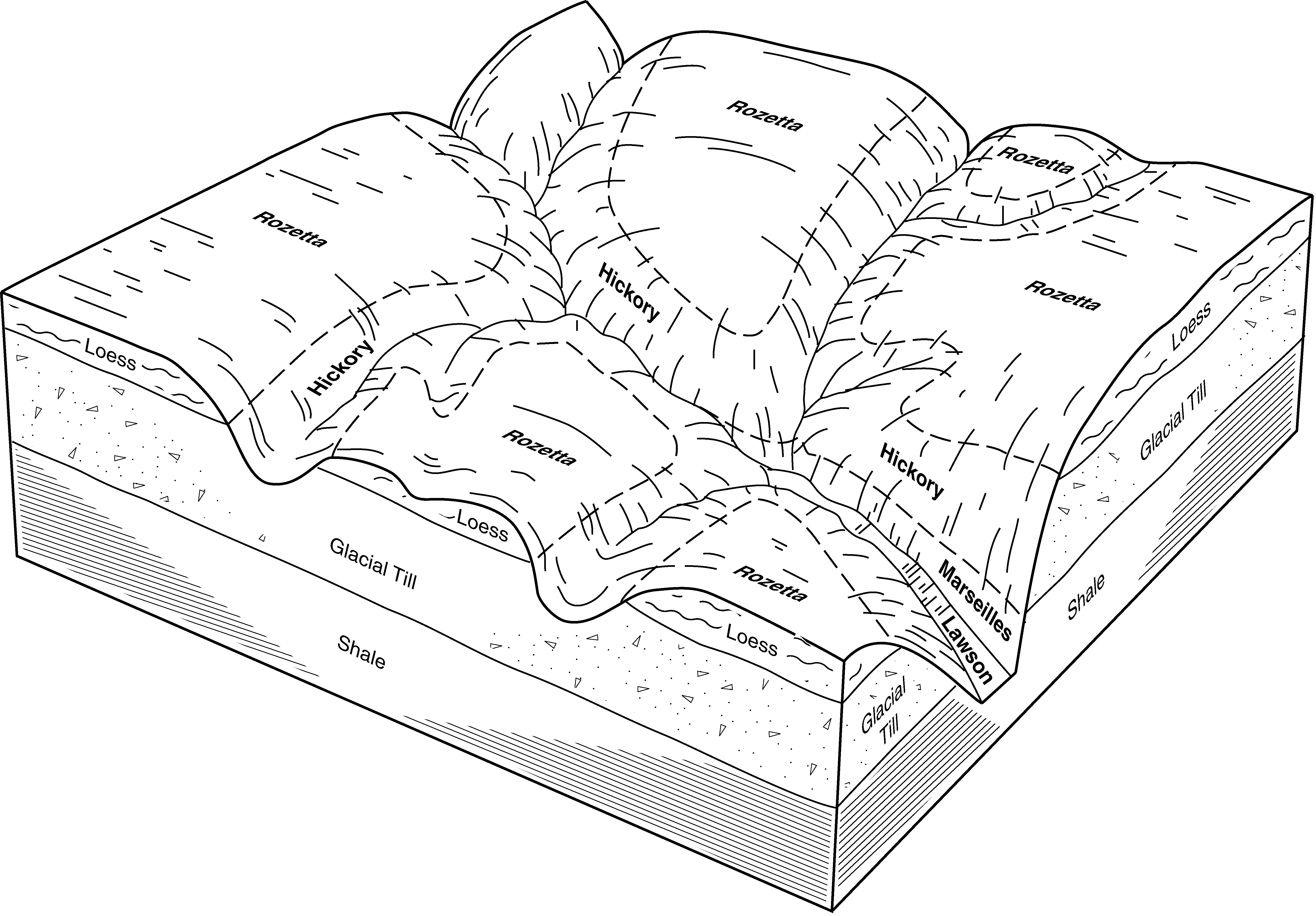
Colo-Hanlon-Lawson complex, channeled, 0 to 2 percent slopes | 1936 | 4032 | 409445 | fr1x | ia127 | 1978 | 1:15840 |
Lawson silty clay loam, 0 to 2 percent slopes | 484 | 1729 | 409486 | fr37 | ia127 | 1978 | 1:15840 |
Lawson-Quiver-Nodaway complex, 0 to 2 percent slopes, occasionally flooded | 716 | 8612 | 2647644 | 2rlzm | ia135 | 1982 | 1:15840 |
Lawson silt loam, heavy till, 0 to 2 percent slopes, occasionally flooded | S484 | 5137 | 2983403 | 2wbdk | ia135 | 1982 | 1:15840 |
Lawson silt loam, 0 to 2 percent slopes | 484 | 1497 | 409791 | frf2 | ia135 | 1982 | 1:15840 |
Lawson silt loam, 0 to 2 percent slopes, occasionally flooded | 484 | 1238 | 412944 | fvps | ia153 | 1993 | 1:12000 |
Lawson silt loam, 0 to 2 percent slopes, occasionally flooded | 484 | 3032 | 410597 | 2yvk0 | ia157 | 1978 | 1:15840 |
Ambraw-Perks-Lawson complex, frequently flooded, 0 to 2 percent slopes | 1539 | 6335 | 410882 | fsk8 | ia163 | 1989 | 1:15840 |
Lawson silt loam, 0 to 2 percent slopes | 484 | 867 | 411010 | fspd | ia163 | 1989 | 1:15840 |
Lawson silt loam, 0 to 2 percent slopes, occasionally flooded | 484 | 1179 | 411495 | 2yvk0 | ia171 | 1989 | 1:15840 |
Lawson silt loam, 0 to 2 percent slopes, rarely flooded | 3484 | 385 | 413070 | fvtv | ia177 | 1994 | 1:12000 |
Lawson-Quiver-Nodaway complex, 0 to 2 percent slopes, occasionally flooded | 716 | 6033 | 2647648 | 2rlzm | ia179 | 1978 | 1:15840 |
Lawson-Quiver-Nodaway complex, 0 to 2 percent slopes, channeled, frequently flooded | 1716 | 198 | 2647649 | 2rlzl | ia179 | 1978 | 1:15840 |
Lawson silt loam, 0 to 2 percent slopes, occasionally flooded | 484 | 4801 | 412058 | 2yvk0 | ia183 | 1983 | 1:15840 |
Lawson silt loam, channeled, 0 to 2 percent slopes | 1484 | 606 | 412006 | ftqj | ia183 | 1983 | 1:15840 |
Lawson-Nodaway-Colo complex, 0 to 2 percent slopes, occasionally flooded | 711 | 5093 | 2422549 | 2m9vr | ia185 | 1966 | 1:15840 |
Lawson-Nodaway-Colo complex, channeled, 0 to 2 percent slopes, frequently flooded | 1711 | 730 | 2422550 | 2m9vs | ia185 | 1966 | 1:15840 |
Lawson-Ossian complex, 0 to 4 percent slopes | 1489B | 9786 | 1382543 | 1hdn5 | ia191 | 2005 | 1:12000 |
Bearpen-Lawson complex, 0 to 2 percent slopes, rarely flooded, overwash | 1084 | 888 | 1401628 | 1j1ht | ia191 | 2005 | 1:12000 |
Lawson silt loam, 1 to 3 percent slopes, occasionally flooded | 484 | 539 | 1008430 | 12vc0 | ia191 | 2005 | 1:12000 |
Lawson silt loam, cool mesic, 0 to 2 percent slopes, frequently flooded | 3451cA | 6781 | 2378677 | 2vpmb | il001 | 1997 | 1:12000 |
Lawson silt loam, cool mesic, 0 to 2 percent slopes, occasionally flooded | 8451A | 1705 | 2378698 | 2vpm3 | il001 | 1997 | 1:12000 |
Lawson silt loam, cool mesic, 0 to 2 percent slopes, occasionally flooded | 451 | 6874 | 173864 | 2vpm3 | il005 | 1981 | 1:12000 |
Lawson silt loam, cool mesic, 0 to 2 percent slopes, occasionally flooded | 8451A | 3823 | 1862802 | 2vpm3 | il011 | 2007 | 1:12000 |
Lawson silt loam, cool mesic, 0 to 2 percent slopes, frequently flooded | 3451cA | 12917 | 3008797 | 2vpmb | il015 | 2005 | 1:12000 |
Lawson silt loam, 0 to 2 percent slopes, rarely flooded | 7451A | 723 | 1542857 | 1nsgl | il015 | 2005 | 1:12000 |
Lawson silt loam, cool mesic, 0 to 2 percent slopes, frequently flooded | 3451cA | 912 | 262820 | 2vpmb | il017 | 2003 | 1:12000 |
Lawson silt loam, cool mesic, 0 to 2 percent slopes, frequently flooded | 3451cA | 6116 | 1428406 | 2vpmb | il029 | 2005 | 1:12000 |
Lawson silt loam, 0 to 2 percent slopes, frequently flooded, brief duration | 3451A | 487 | 2512956 | 2ww9g | il031 | 2008 | 1:12000 |
Lawson silt loam, cool mesic, 0 to 2 percent slopes, frequently flooded | 3451cA | 608 | 174832 | 2vpmb | il035 | 1992 | 1:15840 |
Lawson silt loam, cool mesic, 0 to 2 percent slopes, frequently flooded | 3451cA | 5151 | 1592510 | 2vpmb | il039 | 2005 | 1:12000 |
Lawson silt loam, cool mesic, 0 to 2 percent slopes, occasionally flooded | 8451A | 743 | 1592509 | 2vpm3 | il039 | 2005 | 1:12000 |
Lawson silt loam, cool mesic, 0 to 2 percent slopes, frequently flooded | 3451cA | 3624 | 173403 | 2vpmb | il051 | 1991 | 1:15840 |
Lawson silt loam, cool mesic, 0 to 2 percent slopes, frequently flooded | 3451cA | 11075 | 615695 | 2vpmb | il057 | 1997 | 1:12000 |
Lawson silt loam, cool mesic, 0 to 2 percent slopes, frequently flooded | 3451cA | 19359 | 211768 | 2vpmb | il061 | 1968 | 1:15840 |
Lawson silt loam, cool mesic, 0 to 2 percent slopes, occasionally flooded | 8451A | 156 | 2542304 | 2vpm3 | il061 | 1968 | 1:15840 |
Lawson silt loam, 0 to 2 percent slopes, frequently flooded, brief duration | 3451A | 2220 | 1590352 | 2ww9g | il063 | 2005 | 1:12000 |
Lawson silt loam, heavy till plain, 0 to 2 percent slopes, occasionally flooded | 8451A | 2088 | 1415917 | 2ww9h | il063 | 2005 | 1:12000 |
Lawson silt loam, cool mesic, 0 to 2 percent slopes, frequently flooded | 3451cA | 10862 | 175185 | 2vpmb | il067 | 1993 | 1:15840 |
Lawson silt loam, cool mesic, 0 to 2 percent slopes, occasionally flooded | 8451A | 774 | 175231 | 2vpm3 | il067 | 1993 | 1:15840 |
Otter-Lawson silt loams, 0 to 2 percent slopes, frequently flooded | 3725A | 9245 | 1412443 | 1jdrp | il071 | 2005 | 1:12000 |
Lawson silt loam, cool mesic, 0 to 2 percent slopes, frequently flooded | 3451cA | 786 | 632716 | 2vpmb | il071 | 2005 | 1:12000 |
Lawson silt loam, 0 to 2 percent slopes, rarely flooded | 7451A | 464 | 1480524 | 1lplv | il071 | 2005 | 1:12000 |
Lawson silt loam, cool mesic, 0 to 2 percent slopes, frequently flooded | 3451cA | 8434 | 728437 | 2vpmb | il083 | 2002 | 1:12000 |
Lawson silt loam, 0 to 2 percent slopes, frequently flooded | 3451A | 4176 | 1949677 | 23fst | il085 | 1990 | 1:12000 |
Lawson silt loam, cool mesic, 0 to 2 percent slopes, frequently flooded | 3451cA | 139 | 3008798 | 2vpmb | il085 | 1990 | 1:12000 |
Lawson silt loam, heavy till plain, 0 to 2 percent slopes, occasionally flooded | 8451A | 93 | 991324 | 2ww9h | il091 | 2003 | 1:12000 |
Lawson silt loam, cool mesic, 0 to 2 percent slopes, frequently flooded | 3451cA | 16177 | 680987 | 2vpmb | il095 | 2002 | 1:12000 |
Lawson silt loam, 0 to 2 percent slopes, frequently flooded, brief duration | 3451A | 2948 | 1030102 | 2ww9g | il099 | 2006 | 1:12000 |
Lawson silt loam, cool mesic, 0 to 2 percent slopes, occasionally flooded | 8451A | 598 | 1427839 | 2vpm3 | il099 | 2006 | 1:12000 |
Lawson silt loam, cool mesic, 0 to 2 percent slopes, frequently flooded | 3451cA | 1300 | 1412394 | 2vpmb | il103 | 2004 | 1:12000 |
Lawson silt loam, cool mesic, 0 to 2 percent slopes, occasionally flooded | 8451A | 188 | 937039 | 2vpm3 | il103 | 2004 | 1:12000 |
Lawson silt loam, 0 to 2 percent slopes, frequently flooded, brief duration | 3451A | 1913 | 176967 | 2ww9g | il105 | 1991 | 1:15840 |
Lawson silt loam, cool mesic, 0 to 2 percent slopes, frequently flooded | 3451cA | 4691 | 1596057 | 2vpmb | il107 | 2006 | 1:12000 |
Lawson silt loam, cool mesic, 0 to 2 percent slopes, occasionally flooded | 8451A | 62 | 1596058 | 2vpm3 | il107 | 2006 | 1:12000 |
Lawson silt loam, cool mesic, 0 to 2 percent slopes, frequently flooded | 3451cA | 3827 | 634099 | 2vpmb | il109 | 2002 | 1:12000 |
Lawson silt loam, cool mesic, 0 to 2 percent slopes, occasionally flooded | 8451A | 8429 | 199150 | 2vpm3 | il113 | 2000 | 1:12000 |
Lawson silt loam, cool mesic, 0 to 2 percent slopes, frequently flooded | 3451cA | 7114 | 1913986 | 2vpmb | il115 | 2007 | 1:12000 |
Lawson silt loam, cool mesic, 0 to 2 percent slopes, frequently flooded | 3451cA | 12095 | 199218 | 2vpmb | il117 | 1999 | 1:12000 |
Lawson silt loam, cool mesic, 0 to 2 percent slopes, frequently flooded | 3451cA | 3454 | 198933 | 2vpmb | il119 | 2001 | 1:12000 |
Lawson silt loam, cool mesic, 0 to 2 percent slopes, frequently flooded | 3451cA | 6 | 1407477 | 2vpmb | il129 | 2005 | 1:12000 |
Lawson silt loam, cool mesic, 0 to 2 percent slopes, frequently flooded | 3451cA | 21444 | 1721542 | 2vpmb | il135 | 2007 | 1:12000 |
Lawson silt loam, cool mesic, 0 to 2 percent slopes, frequently flooded | 3451cA | 10529 | 1672160 | 2vpmb | il137 | 1984 | 1:15840 |
Lawson silt loam, cool mesic, 0 to 2 percent slopes, frequently flooded | 3451cA | 2698 | 246538 | 2vpmb | il139 | 1999 | 1:12000 |
Lawson silt loam, cool mesic, 0 to 2 percent slopes, frequently flooded | 3451cA | 16277 | 1398757 | 2vpmb | il141 | 2005 | 1:12000 |
Lawson silt loam, cool mesic, 0 to 2 percent slopes, frequently flooded | 3451cA | 3994 | 208992 | 2vpmb | il143 | 1986 | 1:15840 |
Lawson silt loam, cool mesic, 0 to 2 percent slopes, occasionally flooded | 8451A | 140 | 2518110 | 2vpm3 | il143 | 1986 | 1:15840 |
Lawson silt loam, cool mesic, 0 to 2 percent slopes, occasionally flooded | 8451A | 1399 | 201976 | 2vpm3 | il149 | 2001 | 1:12000 |
Lawson silt loam, cool mesic, 0 to 2 percent slopes, frequently flooded | 3451cA | 4449 | 198697 | 2vpmb | il161 | 2002 | 1:12000 |
Lawson silt loam, 0 to 2 percent slopes, rarely flooded | 7451A | 497 | 636630 | pcgg | il161 | 2002 | 1:12000 |
Lawson silt loam, cool mesic, 0 to 2 percent slopes, frequently flooded | 3451cA | 8730 | 199321 | 2vpmb | il167 | 1999 | 1:12000 |
Lawson silt loam, cool mesic, 0 to 2 percent slopes, frequently flooded | 3451cA | 2720 | 2542091 | 2vpmb | il171 | 1984 | 1:12000 |
Lawson silt loam, cool mesic, 0 to 2 percent slopes, frequently flooded | 3451cA | 7429 | 179093 | 2vpmb | il175 | 1992 | 1:15840 |
Lawson silt loam, cool mesic, 0 to 2 percent slopes, occasionally flooded | 8451A | 239 | 2542394 | 2vpm3 | il175 | 1992 | 1:15840 |
Lawson silt loam, cool mesic, 0 to 2 percent slopes, occasionally flooded | 8451A | 13880 | 1651471 | 2vpm3 | il177 | 2006 | 1:12000 |
Lawson silt loam, 0 to 2 percent slopes, frequently flooded | 3451A | 570 | 1709787 | 1vd5f | il177 | 2006 | 1:12000 |
Lawson silt loam, cool mesic, 0 to 2 percent slopes, frequently flooded | 3451cA | 474 | 3008799 | 2vpmb | il177 | 2006 | 1:12000 |
Lawson silt loam, cool mesic, 0 to 2 percent slopes, frequently flooded | 3451cA | 2265 | 179402 | 2vpmb | il179 | 1991 | 1:15840 |
Lawson silt loam, cool mesic, 0 to 2 percent slopes, frequently flooded | 3451cA | 5546 | 244934 | 2vpmb | il187 | 2002 | 1:12000 |
Lawson silt loam, cool mesic, 0 to 2 percent slopes, frequently flooded | 3451cA | 4802 | 793120 | 2vpmb | il195 | 2003 | 1:12000 |
Lawson silt loam, cool mesic, 0 to 2 percent slopes, occasionally flooded | 8451A | 449 | 793148 | 2vpm3 | il195 | 2003 | 1:12000 |
Lawson silt loam, heavy till plain, 0 to 2 percent slopes, occasionally flooded | 8451A | 5669 | 215044 | 2ww9h | il197 | 2002 | 1:12000 |
Lawson silt loam, 0 to 2 percent slopes, frequently flooded, brief duration | 3451A | 575 | 618730 | 2ww9g | il197 | 2002 | 1:12000 |
Lawson silt loam, cool mesic, 0 to 2 percent slopes, occasionally flooded | 8451A | 4278 | 174224 | 2vpm3 | il201 | 1997 | 1:12000 |
Lawson silt loam, cool mesic, 0 to 2 percent slopes, occasionally flooded | 8451A | 4999 | 1913195 | 2vpm3 | il203 | 2008 | 1:12000 |
Lawson silt loam | 226 | 442 | 396809 | f9x9 | mn037 | 1980 | 1:15840 |
Otter-Lawson complex, bedrock substratum, 0 to 2 percent slopes, occasionally flooded | N595A | 649 | 1385062 | 1hh8f | mn039 | 2005 | 1:12000 |
Kennebec-Lawson, channeled, complex, 0 to 3 percent slopes, flooded | N619A | 2972 | 1675878 | 1t7wl | mn049 | 2007 | 1:12000 |
Kennebec-Lawson, channeled, complex, 0 to 3 percent slopes, flooded | N619A | 229 | 2216199 | 2dd49 | mn157 | 2008 | 1:12000 |
Lawson silt loam, cool mesic, 0 to 2 percent slopes, occasionally flooded | 66042 | 1498 | 888765 | 2vpm3 | mo045 | 1992 | 1:24000 |
Lawson silt loam, 0 to 3 percent slopes, occasionally flooded | 608A | 5972 | 2806640 | 1lmy9 | wi049 | 1960 | 1:20000 |
Lawson silt loam, calcareous variant | 7608A | 182 | 3268662 | g785 | wi059 | 2023 | 1:15840 |
Lawson silt loam, 0 to 3 percent slopes, occasionally flooded | 608A | 228 | 2518482 | 1lmy9 | wi063 | 2001 | 1:12000 |
Lawson silt loam | 608A | 5339 | 424840 | g82j | wi065 | 1964 | 1:15840 |
Lawson silt loam | 7608A | 504 | 3403302 | g94p | wi079 | 2023 | 1:15840 |
Lawson silt loam, calcareous variant | 7608A | 128 | 3268793 | g785 | wi101 | 2023 | 1:15840 |
Lawson silt loam | 7608A | 94 | 3403392 | g94p | wi133 | 2023 | 1:15840 |


