| Larkin silt loam, 12 to 35 percent slopes | 24 | 25332 | 2487269 | 2ph6h | id057 | 2013 | 1:24000 |
Larkin silt loam, 3 to 12 percent slopes | 23 | 7172 | 2487268 | 2ph6g | id057 | 2013 | 1:24000 |
Driscoll-Larkin complex, 7 to 25 percent slopes | 8 | 5520 | 2487253 | 2ph5z | id057 | 2013 | 1:24000 |
Southwick-Larkin complex, 12 to 25 percent slopes | 45j | 172 | 2502077 | 2ntc | id057 | 2013 | 1:24000 |
Larkin-Driscoll complex, 10 to 20 percent slopes | 24j | 13 | 2502074 | 2nxm | id057 | 2013 | 1:24000 |
Larkin silt loam, 3 to 12 percent slopes | 138 | 2460 | 79428 | 2nn6 | id606 | 1976 | 1:24000 |
Larkin silt loam, 3 to 20 percent slopes, eroded | 140 | 1810 | 79430 | 2nn8 | id606 | 1976 | 1:24000 |
Larkin silt loam, 12 to 20 percent slopes | 139 | 302 | 79429 | 2nn7 | id606 | 1976 | 1:24000 |
Larkin-Southwick complex, 3 to 12 percent slopes | 364 | 113 | 2662980 | 1nvhp | id606 | 1976 | 1:24000 |
Larkin-Southwick complex, 8 to 15 percent slopes | 6041 | 59 | 2662926 | nvfb | id606 | 1976 | 1:24000 |
Larkin silt loam, 0 to 8 percent slopes | 6040 | 59 | 2662925 | nvf9 | id606 | 1976 | 1:24000 |
Larkin silt loam, 12 to 20 percent slopes | 361 | 41 | 2662977 | 1hn7r | id606 | 1976 | 1:24000 |
Larkin-Southwick complex, 15 to 25 percent slopes | 6042 | 18 | 2662927 | nvfd | id606 | 1976 | 1:24000 |
Larkin-Driscoll complex, 3 to 12 percent slopes | 9363 | 15 | 2662935 | 2mdm6 | id606 | 1976 | 1:24000 |
Driscoll-Larkin complex, 8 to 15 percent slopes | 6141 | 11 | 2662930 | 2dtzj | id606 | 1976 | 1:24000 |
Larkin-Driscoll complex, 12 to 25 percent slopes | 367 | 8 | 2662985 | 2kp7w | id606 | 1976 | 1:24000 |
Southwick-Larkin complex, 15 to 25 percent slopes | 6045 | 6 | 2662928 | 2mdq1 | id606 | 1976 | 1:24000 |
Southwick-Larkin complex, 12 to 25 percent slopes | 122 | 10663 | 79588 | 2ntc | id611 | 1994 | 1:24000 |
Larkin-Driscoll complex, 10 to 20 percent slopes | 74 | 9780 | 79689 | 2nxm | id611 | 1994 | 1:24000 |
Driscoll-Larkin complex, 2 to 10 percent slopes | 36 | 6878 | 79647 | 2nw8 | id611 | 1994 | 1:24000 |
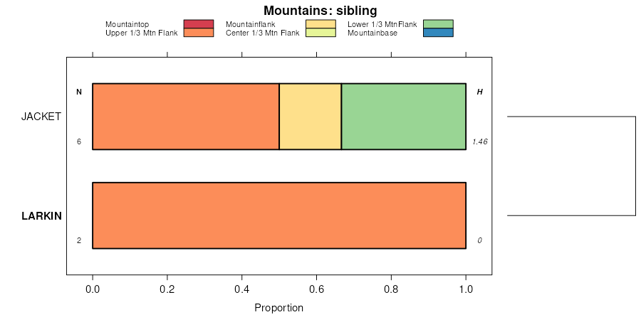
Jacket-Larkin complex, 20 to 50 percent slopes | 47 | 2453 | 79659 | 2nwn | id611 | 1994 | 1:24000 |
Driscoll-Larkin complex, 12 to 25 percent slopes | 74j | 104 | 679207 | qsrx | id611 | 1994 | 1:24000 |
Driscoll-Larkin complex, 12 to 25 percent slopes | 59 | 2256 | 777317 | v2vr | id612 | 2003 | 1:24000 |
Larkin-Driscoll complex, 25 to 50 percent slopes | 159 | 1270 | 777319 | v2vt | id612 | 2003 | 1:24000 |
Southwick-Larkin complex, 12 to 25 percent slopes | 218 | 1014 | 777383 | v2xw | id612 | 2003 | 1:24000 |
Larkin silt loam, 5 to 20 percent slopes | 2y6tj | 393 | 3098879 | 2y6tj | id617 | 1976 | 1:24000 |
Jacket-Larkin complex, 15 to 40 percent slopes | 2y6tb | 390 | 3098876 | 2y6tb | id617 | 1976 | 1:24000 |
Larkin silt loam, 20 to 40 percent slopes | 53 | 234 | 154028 | 2y6tk | id617 | 1976 | 1:24000 |
Larkin silt loam, 5 to 20 percent slopes | 2y6tj | 447 | 3098903 | 2y6tj | id618 | 1965 | 1:24000 |
Jacket-Larkin complex, 15 to 40 percent slopes | 2y6tb | 323 | 3098899 | 2y6tb | id618 | 1965 | 1:24000 |
Larkin-Southwick complex, 3 to 12 percent slopes | 364 | 4493 | 1544813 | 1nvhp | id620 | 2013 | 1:24000 |
Larkin-Driscoll complex, 3 to 12 percent slopes | 363 | 2555 | 1544812 | 1nvhn | id620 | 2013 | 1:24000 |
Larkin silt loam, 3 to 12 percent slopes | 360 | 2370 | 1389845 | 1hn7q | id620 | 2013 | 1:24000 |
Larkin silt loam, 12 to 20 percent slopes | 361 | 1386 | 1389846 | 1hn7r | id620 | 2013 | 1:24000 |
Larkin-Driscoll complex, 12 to 25 percent slopes | 367 | 580 | 2373914 | 2kp7w | id620 | 2013 | 1:24000 |
Larkin-Southwick complex, 8 to 15 percent slopes | 6041 | 17017 | 621219 | nvfb | wa063 | 2012 | 1:24000 |
Larkin silt loam, 0 to 8 percent slopes | 6040 | 4310 | 621218 | nvf9 | wa063 | 2012 | 1:24000 |
Driscoll-Larkin complex, 8 to 15 percent slopes | 6141 | 3109 | 2229505 | 2dtzj | wa063 | 2012 | 1:24000 |
Larkin-Southwick complex, 15 to 25 percent slopes | 6042 | 2516 | 621221 | nvfd | wa063 | 2012 | 1:24000 |
Larkin-Driscoll complex, 0 to 8 percent slopes | 6043 | 851 | 2229504 | 2dtzh | wa063 | 2012 | 1:24000 |
Southwick-Larkin complex, 15 to 25 percent slopes | 6045 | 827 | 2425286 | 2mdq1 | wa063 | 2012 | 1:24000 |
Larkin-Driscoll complex, 3 to 12 percent slopes | 9363 | 692 | 2425198 | 2mdm6 | wa063 | 2012 | 1:24000 |
Larkin-Driscoll complex, 12 to 25 percent slopes | 9367 | 212 | 2425200 | 2mdm8 | wa063 | 2012 | 1:24000 |
Larkin-Southwick complex, 3 to 12 percent slopes | 9364 | 132 | 2425199 | 2mdm7 | wa063 | 2012 | 1:24000 |
Larkin silt loam, 15 to 25 percent slopes | 51 | 2779 | 68548 | 29b7 | wa075 | 1975 | 1:20000 |
Larkin silt loam, 40 to 55 percent slopes | 53 | 983 | 68550 | 29b9 | wa075 | 1975 | 1:20000 |
Larkin silt loam, 25 to 40 percent slopes | 52 | 748 | 68549 | 29b8 | wa075 | 1975 | 1:20000 |
Larkin silt loam, 3 to 15 percent slopes | 50 | 513 | 68547 | 29b6 | wa075 | 1975 | 1:20000 |
Driscoll-Larkin complex, 8 to 15 percent slopes | 6141 | 29 | 2651377 | 2dtzj | wa075 | 1975 | 1:20000 |
Larkin-Driscoll complex, 0 to 8 percent slopes | 6043 | 17 | 2651365 | 2dtzh | wa075 | 1975 | 1:20000 |
Larkin-Southwick complex, 15 to 25 percent slopes | 6042 | 12 | 2651364 | nvfd | wa075 | 1975 | 1:20000 |
Larkin-Driscoll complex, 3 to 12 percent slopes | 9363 | 11 | 2651382 | 2mdm6 | wa075 | 1975 | 1:20000 |
Larkin silt loam, 40 to 65 percent slopes | LaF | 6201 | 69674 | 2bhk | wa613 | 1967 | 1:20000 |
Larkin silt loam, moderately shallow, 0 to 25 percent slopes | LkD | 1740 | 69675 | 2bhl | wa613 | 1967 | 1:20000 |
Larkin silt loam, moderately shallow, 25 to 40 percent slopes | LkE | 864 | 69676 | 2bhm | wa613 | 1967 | 1:20000 |
Larkin silty clay loam, 15 to 25 percent slopes, severely eroded | LrD3 | 593 | 69677 | 2bhn | wa613 | 1967 | 1:20000 |
Larkin silt loam, 25 to 40 percent slopes | LaE | 2279 | 69810 | 2bmy | wa623 | 1970 | 1:20000 |
Larkin silt loam, 40 to 60 percent slopes | LaF | 2105 | 69811 | 2bmz | wa623 | 1970 | 1:20000 |
Larkin silt loam, 15 to 25 percent slopes | LaD | 1558 | 69809 | 2bmx | wa623 | 1970 | 1:20000 |
Larkin silt loam, 0 to 15 percent slopes | LaC | 1031 | 69808 | 2bmw | wa623 | 1970 | 1:20000 |


