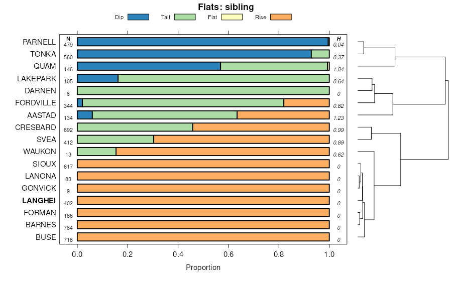
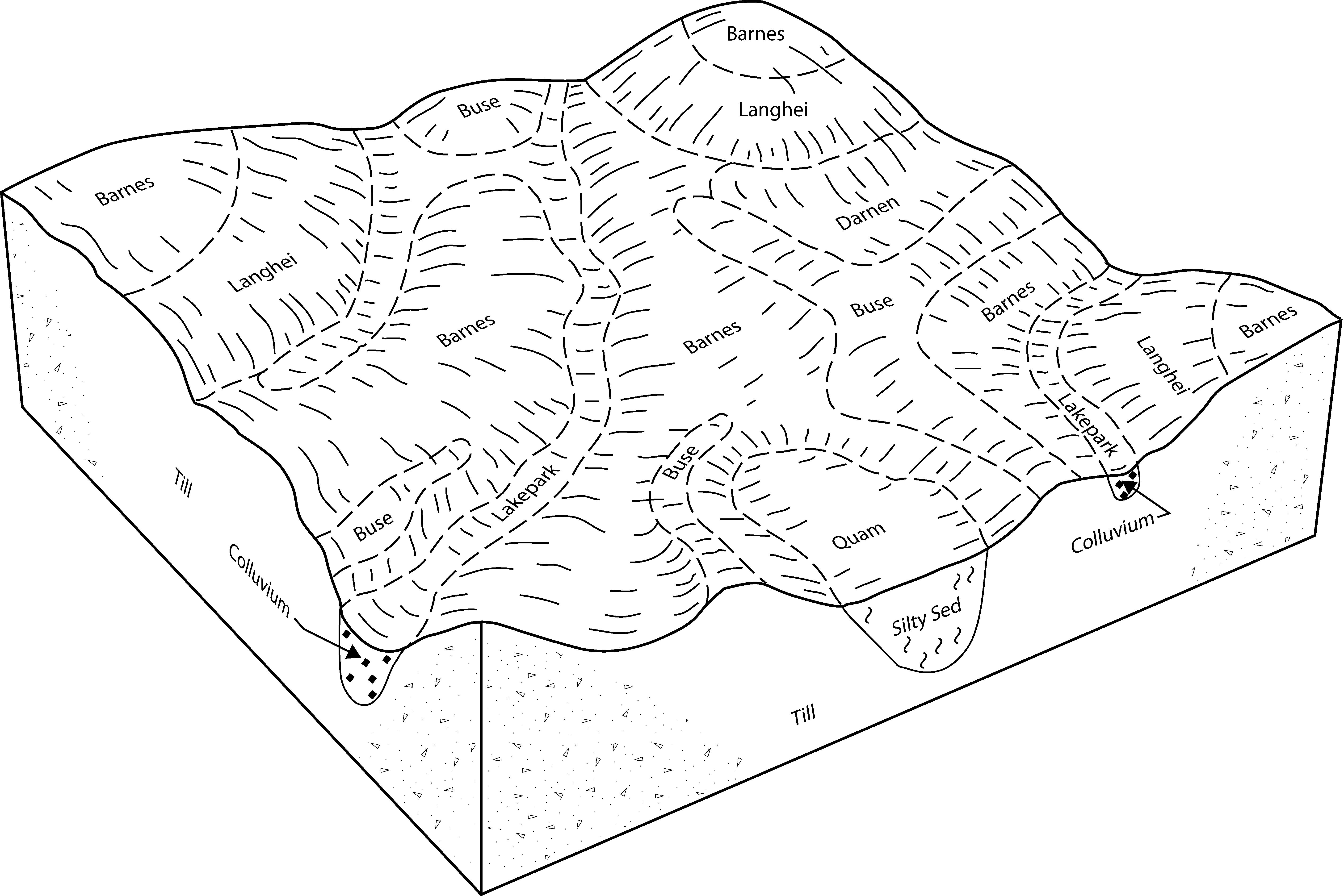
| Langhei-Barnes, moderately eroded, complex, 12 to 20 percent slopes | 942D2 | 1178 | 397579 | 2w0lw | mn005 | 1994 | 1:20000 |
Formdale-Langhei-Sandberg complex, 6 to 12 percent slopes, eroded | 579C2 | 954 | 397544 | fbp0 | mn005 | 1994 | 1:20000 |
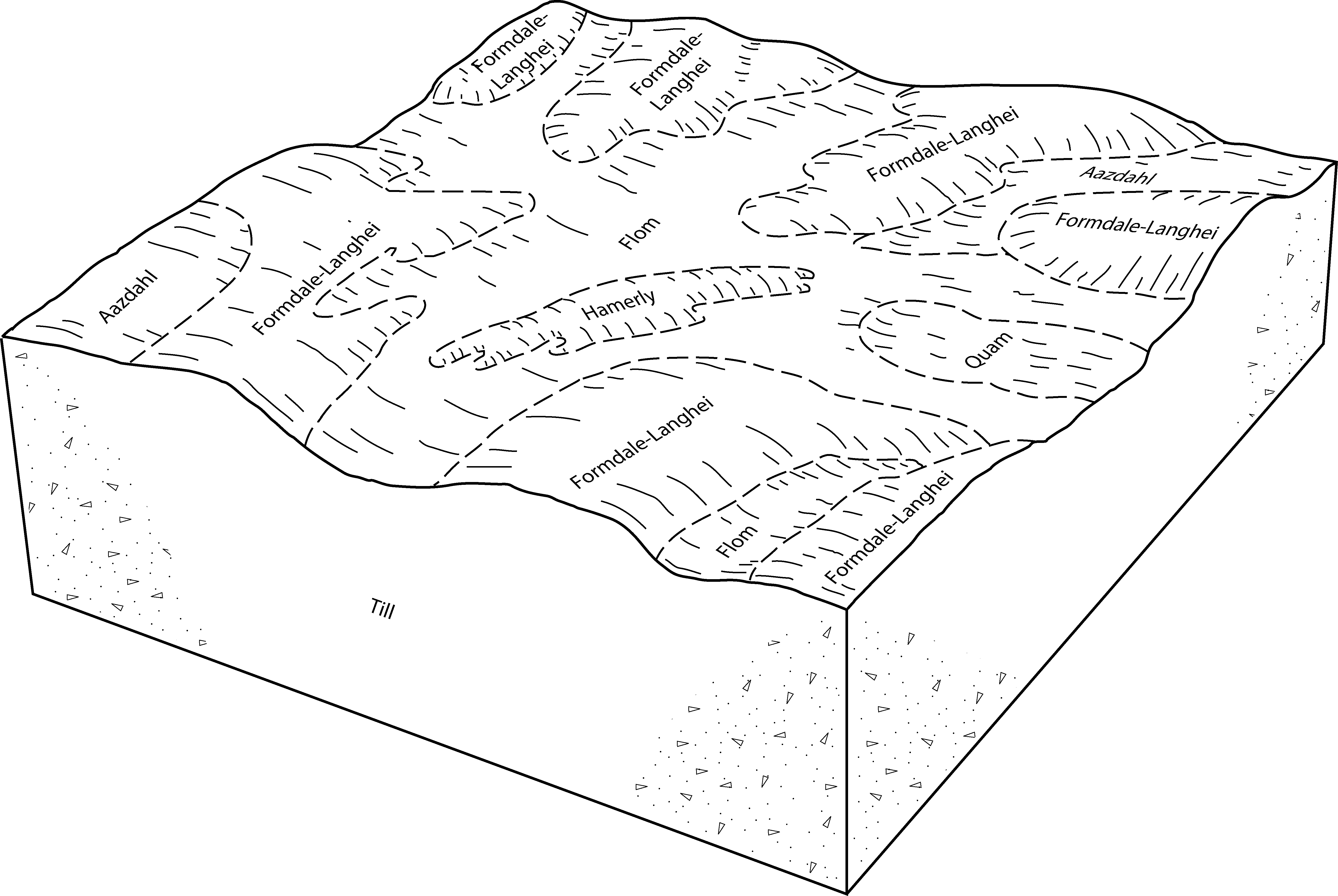
Langhei-Barnes-Darnen complex, 5 to 30 percent slopes | J120E | 767 | 3182517 | 2yw62 | mn005 | 1994 | 1:20000 |
Langhei-Formdale complex, 20 to 30 percent slopes | 943E | 67 | 397581 | fbq6 | mn005 | 1994 | 1:20000 |
Langhei-Barnes-Darnen complex, 5 to 30 percent slopes | J120E | 619 | 3182535 | 2yw62 | mn011 | 1990 | 1:20000 |
Langhei-Barnes, moderately eroded, complex, 12 to 20 percent slopes | J37D2 | 399 | 2423049 | 2w0lw | mn023 | 1980 | 1:15840 |
Langhei loam, 12 to 40 percent slopes | J24F | 60 | 2423040 | 2w0m1 | mn023 | 1980 | 1:15840 |
Langhei-Barnes, moderately eroded, complex, 6 to 12 percent slopes | J36C2 | 31 | 2423048 | 2w0lv | mn023 | 1980 | 1:15840 |
Langhei-Barnes, moderately eroded, complex, 6 to 12 percent slopes | 942C2 | 25550 | 357022 | 2w0lv | mn027 | 1980 | 1:20000 |
Langhei-Barnes, moderately eroded, complex, 12 to 20 percent slopes | 942D2 | 6893 | 357023 | 2w0lw | mn027 | 1980 | 1:20000 |
Waukon, moderately eroded-Langhei complex, 6 to 12 percent slopes | 38C2 | 6133 | 356967 | 2vv6f | mn027 | 1980 | 1:20000 |
Waukon, moderately eroded-Langhei complex, 12 to 20 percent slopes | 38D2 | 2550 | 356969 | 2vv6h | mn027 | 1980 | 1:20000 |
Waukon-Langhei complex, 2 to 6 percent slopes | 967B2 | 1636 | 357026 | 2vv6c | mn027 | 1980 | 1:20000 |
Waukon, moderately eroded-Langhei complex, 6 to 12 percent slopes | 38C2 | 3177 | 430497 | 2vv6f | mn029 | 1993 | 1:20000 |
Waukon, moderately eroded-Langhei complex, 12 to 20 percent slopes | 38D2 | 455 | 430499 | 2vv6h | mn029 | 1993 | 1:20000 |
Waukon-Langhei complex, 2 to 6 percent slopes | WlB2 | 21318 | 397343 | 2vv6c | mn041 | 1970 | 1:12000 |
Waukon, moderately eroded-Langhei complex, 6 to 12 percent slopes | WlC2 | 21062 | 397344 | 2vv6f | mn041 | 1970 | 1:12000 |
Langhei-Barnes, moderately eroded, complex, 12 to 20 percent slopes | LgD2 | 4972 | 397289 | 2w0lw | mn041 | 1970 | 1:12000 |
Waukon, moderately eroded-Langhei complex, 12 to 20 percent slopes | WaD2 | 4233 | 397339 | 2vv6h | mn041 | 1970 | 1:12000 |
Waukon-Langhei-Sioux complex, 6 to 12 percent slopes, eroded | WsC2 | 1748 | 397346 | fbgm | mn041 | 1970 | 1:12000 |
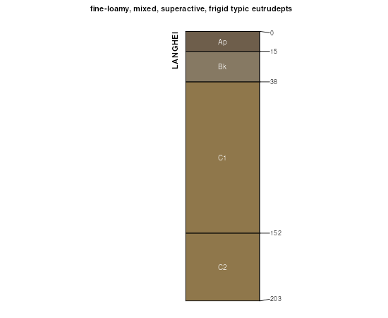
Langhei loam, 12 to 40 percent slopes | LeF | 1706 | 397288 | 2w0m1 | mn041 | 1970 | 1:12000 |
Waukon-Langhei-Sioux complex, 2 to 6 percent slopes, eroded | WsB2 | 1462 | 397345 | fbgl | mn041 | 1970 | 1:12000 |
Langhei-Waukon loams, 18 to 24 percent slopes | LkE | 786 | 397291 | fbdv | mn041 | 1970 | 1:12000 |
Langhei-Waukon-Sioux complex, 12 to 25 percent slopes | LwD | 762 | 397292 | fbdw | mn041 | 1970 | 1:12000 |
Langhei-Barnes, moderately eroded, complex, 6 to 12 percent slopes | 942C2 | 7628 | 398072 | 2w0lv | mn051 | 1974 | 1:20000 |
Langhei-Barnes, moderately eroded, complex, 12 to 20 percent slopes | 942D2 | 2648 | 398073 | 2w0lw | mn051 | 1974 | 1:20000 |
Langhei-Barnes-Darnen complex, 5 to 30 percent slopes | J120E | 1517 | 3182553 | 2yw62 | mn051 | 1974 | 1:20000 |
Langhei loam, 12 to 40 percent slopes | 220E | 836 | 398028 | 2w0m1 | mn051 | 1974 | 1:20000 |
Waukon, moderately eroded-Langhei complex, 6 to 12 percent slopes | 38C | 311 | 398046 | 2vv6f | mn051 | 1974 | 1:20000 |
Waukon, moderately eroded-Langhei complex, 6 to 12 percent slopes | 807C | 1827 | 398716 | 2vv6f | mn067 | 1983 | 1:20000 |
Waukon-Langhei complex, 2 to 6 percent slopes | 807B | 1673 | 398715 | 2vv6c | mn067 | 1983 | 1:20000 |
Langhei-Barnes, moderately eroded, complex, 6 to 12 percent slopes | J36C2 | 1200 | 2945770 | 2w0lv | mn067 | 1983 | 1:20000 |
Waukon, moderately eroded-Langhei complex, 12 to 20 percent slopes | 807D | 959 | 398717 | 2vv6h | mn067 | 1983 | 1:20000 |
Langhei-Barnes, moderately eroded, complex, 12 to 20 percent slopes | J37D2 | 635 | 2945753 | 2w0lw | mn067 | 1983 | 1:20000 |
Langhei-Barnes, moderately eroded, complex, 6 to 12 percent slopes | 942C2 | 3048 | 430360 | 2w0lv | mn073 | 1994 | 1:20000 |
Langhei loam, 12 to 40 percent slopes | 437F | 1350 | 430313 | 2w0m1 | mn073 | 1994 | 1:20000 |
Langhei-Barnes, moderately eroded, complex, 12 to 20 percent slopes | 220D2 | 745 | 430274 | 2w0lw | mn073 | 1994 | 1:20000 |
Waukon, moderately eroded-Langhei complex, 6 to 12 percent slopes | 967C2 | 12507 | 399264 | 2vv6f | mn087 | 1992 | 1:20000 |
Waukon-Langhei complex, 2 to 6 percent slopes | 967B | 11859 | 399263 | 2vv6c | mn087 | 1992 | 1:20000 |
Waukon, moderately eroded-Langhei complex, 12 to 20 percent slopes | 979D2 | 2045 | 399265 | 2vv6h | mn087 | 1992 | 1:20000 |
Langhei-Barnes, moderately eroded, complex, 12 to 20 percent slopes | 942D2 | 860 | 399262 | 2w0lw | mn087 | 1992 | 1:20000 |
Langhei-Barnes, moderately eroded, complex, 6 to 12 percent slopes | LbC2 | 1956 | 357246 | 2w0lv | mn107 | 1970 | 1:20000 |
Langhei-Barnes, moderately eroded, complex, 12 to 20 percent slopes | LbD2 | 950 | 357247 | 2w0lw | mn107 | 1970 | 1:20000 |
Waukon-Langhei complex, 2 to 6 percent slopes | WkB2 | 892 | 357282 | 2vv6c | mn107 | 1970 | 1:20000 |
Waukon, moderately eroded-Langhei complex, 6 to 12 percent slopes | WkC | 309 | 357283 | 2vv6f | mn107 | 1970 | 1:20000 |
Langhei loam, 12 to 40 percent slopes | LbE | 242 | 357248 | 2w0m1 | mn107 | 1970 | 1:20000 |
Waukon, moderately eroded-Langhei complex, 12 to 20 percent slopes | WkD | 240 | 357284 | 2vv6h | mn107 | 1970 | 1:20000 |
Waukon, moderately eroded-Langhei complex, 6 to 12 percent slopes | 38C2 | 11000 | 435748 | 2vv6f | mn111 | 1996 | 1:20000 |
Waukon, moderately eroded-Langhei complex, 12 to 20 percent slopes | 38D2 | 4825 | 435749 | 2vv6h | mn111 | 1996 | 1:20000 |
Langhei-Barnes, moderately eroded, complex, 12 to 20 percent slopes | 942D2 | 1948 | 435972 | 2w0lw | mn111 | 1996 | 1:20000 |
Langhei-Barnes-Darnen complex, 5 to 30 percent slopes | J120E | 625 | 3182571 | 2yw62 | mn111 | 1996 | 1:20000 |
Waukon, moderately eroded-Langhei complex, 6 to 12 percent slopes | 38C2 | 4352 | 352247 | 2vv6f | mn119 | 1996 | 1:20000 |
Waukon, moderately eroded-Langhei complex, 12 to 20 percent slopes | 38D2 | 1694 | 352249 | 2vv6h | mn119 | 1996 | 1:20000 |
Waukon-Langhei complex, 2 to 6 percent slopes | 967B | 46 | 352335 | 2vv6c | mn119 | 1996 | 1:20000 |
Langhei-Barnes, moderately eroded, complex, 6 to 12 percent slopes | LnC2 | 16871 | 401363 | 2w0lv | mn121 | 1968 | 1:20000 |
Langhei-Barnes, moderately eroded, complex, 12 to 20 percent slopes | LnD2 | 14491 | 401364 | 2w0lw | mn121 | 1968 | 1:20000 |
Langhei loam, 12 to 40 percent slopes | LlF | 4578 | 401360 | 2w0m1 | mn121 | 1968 | 1:20000 |
Langhei-Barnes loams, 2 to 6 percent slopes, eroded | LnB2 | 3108 | 401362 | fgn5 | mn121 | 1968 | 1:20000 |
Waukon-Langhei complex, 2 to 6 percent slopes | WdB2 | 1303 | 401415 | 2vv6c | mn121 | 1968 | 1:20000 |
Langhei stony loam, 6 to 40 percent slopes | LmF | 735 | 401361 | fgn4 | mn121 | 1968 | 1:20000 |
Barnes-Langhei-Renshaw loams, 6 to 12 percent slopes | BdC | 673 | 401322 | fglw | mn121 | 1968 | 1:20000 |
Waukon, moderately eroded-Langhei complex, 6 to 12 percent slopes | WdC2 | 494 | 401416 | 2vv6f | mn121 | 1968 | 1:20000 |
Langhei-Barnes-Sioux complex, 12 to 18 percent slopes, eroded | LoD2 | 490 | 401365 | fgn8 | mn121 | 1968 | 1:20000 |
Barnes-Langhei-Renshaw loams, 2 to 6 percent slopes, eroded | BdB2 | 414 | 401321 | fglv | mn121 | 1968 | 1:20000 |
Langhei-Barnes-Darnen complex, 5 to 30 percent slopes | J120E | 46 | 3182589 | 2yw62 | mn121 | 1968 | 1:20000 |
Waukon, moderately eroded-Langhei complex, 6 to 12 percent slopes | 38C | 7317 | 428130 | 2vv6f | mn145 | 1980 | 1:15840 |
Waukon, moderately eroded-Langhei complex, 12 to 20 percent slopes | 38D | 1384 | 428131 | 2vv6h | mn145 | 1980 | 1:15840 |
Langhei-Barnes, moderately eroded, complex, 12 to 20 percent slopes | 954D | 664 | 428189 | 2w0lw | mn145 | 1980 | 1:15840 |
Langhei-Barnes-Darnen complex, 5 to 30 percent slopes | J120E | 966 | 3182607 | 2yw62 | mn149 | 1966 | 1:15840 |
Langhei-Barnes, moderately eroded, complex, 12 to 20 percent slopes | BoD2 | 612 | 428321 | 2w0lw | mn149 | 1966 | 1:15840 |
Langhei loam, 12 to 40 percent slopes | BnE | 340 | 428320 | 2w0m1 | mn149 | 1966 | 1:15840 |
Langhei-Barnes, moderately eroded, complex, 6 to 12 percent slopes | J36C2 | 2058 | 434819 | 2w0lv | mn151 | 2000 | 1:12000 |
Langhei-Barnes, moderately eroded, complex, 12 to 20 percent slopes | J37D2 | 883 | 434820 | 2w0lw | mn151 | 2000 | 1:12000 |
Langhei loam, 12 to 40 percent slopes | J24F | 807 | 434786 | 2w0m1 | mn151 | 2000 | 1:12000 |
Waukon, moderately eroded-Langhei complex, 6 to 12 percent slopes | 38C | 4036 | 428536 | 2vv6f | mn153 | 1985 | 1:20000 |
Waukon, moderately eroded-Langhei complex, 12 to 20 percent slopes | 967D | 1325 | 428587 | 2vv6h | mn153 | 1985 | 1:20000 |
Langhei-Barnes-Darnen complex, 5 to 30 percent slopes | J120E | 3492 | 3182624 | 2yw62 | mn155 | 1986 | 1:20000 |
Langhei loam, 12 to 40 percent slopes | 437E | 151 | 357363 | 2w0m1 | mn155 | 1986 | 1:20000 |
Langhei-Barnes, moderately eroded, complex, 6 to 12 percent slopes | 942C2 | 2084 | 357466 | 2w0lv | mn167 | 1985 | 1:20000 |
Langhei-Barnes, moderately eroded, complex, 12 to 20 percent slopes | 942D2 | 216 | 357467 | 2w0lw | mn167 | 1985 | 1:20000 |
Barnes-Buse-Langhei loams, 6 to 9 percent slopes | G143C | 48295 | 2573571 | 2pwz5 | nd003 | 1988 | 1:20000 |
Barnes-Buse-Langhei loams, 9 to 15 percent slopes | G143D | 8270 | 2573570 | 2pwz4 | nd003 | 1988 | 1:20000 |
Buse-Barnes-Langhei loams, 4 to 15 percent slopes | F1143D | 17948 | 3247639 | 2ykx4 | nd005 | | 1:12000 |
Barnes-Buse-Langhei loams, 6 to 9 percent slopes | G143C | 1030 | 2573727 | 2pwz5 | nd005 | | 1:12000 |
Barnes-Buse-Langhei loams, 9 to 15 percent slopes | G143D | 614 | 2573716 | 2pwz4 | nd005 | | 1:12000 |
Barnes-Buse-Langhei loams, 6 to 9 percent slopes | F143C | 80 | 2587645 | 2q4gs | nd005 | | 1:12000 |
Barnes-Buse-Langhei loams, 6 to 9 percent slopes | F143C | 5054 | 2585935 | 2q4gs | nd009 | 1981 | 1:20000 |
Barnes-Buse-Langhei loams, 9 to 15 percent slopes | F143D | 1948 | 2586031 | 2q4gt | nd009 | 1981 | 1:20000 |
Barnes-Buse-Langhei loams, 6 to 9 percent slopes | F143C | 272 | 2585831 | 2q4gs | nd013 | 1991 | 1:24000 |
Barnes-Buse-Langhei loams, 6 to 9 percent slopes | G143C | 6280 | 2575071 | 2pwz5 | nd017 | 1983 | 1:20000 |
Barnes-Buse-Langhei loams, 9 to 15 percent slopes | G143D | 1080 | 2575062 | 2pwz4 | nd017 | 1983 | 1:20000 |
Barnes-Buse-Langhei loams, 6 to 9 percent slopes | F143C | 7198 | 2587527 | 2q4gs | nd019 | 1987 | 1:20000 |
Barnes-Buse-Langhei loams, 9 to 15 percent slopes | F143D | 1228 | 2587528 | 2q4gt | nd019 | 1987 | 1:20000 |
Buse-Barnes-Langhei loams, 4 to 15 percent slopes | F1143D | 1071 | 3247660 | 2ykx4 | nd019 | 1987 | 1:20000 |
Barnes-Buse-Langhei loams, 6 to 9 percent slopes | G143C | 11441 | 2575252 | 2pwz5 | nd021 | 1989 | 1:20000 |
Barnes-Buse-Langhei loams, 9 to 15 percent slopes | G143D | 927 | 2575251 | 2pwz4 | nd021 | 1989 | 1:20000 |
Barnes-Buse-Langhei loams, 6 to 9 percent slopes | G143C | 1554 | 2575394 | 2pwz5 | nd027 | | 1:12000 |
Barnes-Buse-Langhei loams, 9 to 15 percent slopes | G143D | 592 | 2575393 | 2pwz4 | nd027 | | 1:12000 |
Barnes-Buse-Langhei loams, 6 to 9 percent slopes | G143C | 8178 | 2576370 | 2pwz5 | nd031 | 1990 | 1:20000 |
Barnes-Buse-Langhei loams, 9 to 15 percent slopes | G143D | 2229 | 2576369 | 2pwz4 | nd031 | 1990 | 1:20000 |
Barnes-Buse-Langhei loams, 6 to 9 percent slopes | G143C | 8462 | 2576501 | 2pwz5 | nd035 | 1980 | 1:20000 |
Barnes-Buse-Langhei loams, 9 to 15 percent slopes | G143D | 1036 | 2576496 | 2pwz4 | nd035 | 1980 | 1:20000 |
Barnes-Buse-Langhei loams, 6 to 9 percent slopes | F143C | 157 | 2587460 | 2q4gs | nd035 | 1980 | 1:20000 |
Barnes-Buse-Langhei loams, 9 to 15 percent slopes | F143D | 3 | 2587480 | 2q4gt | nd035 | 1980 | 1:20000 |
Barnes-Buse-Langhei loams, 6 to 9 percent slopes | G143C | 3495 | 2576557 | 2pwz5 | nd039 | 1991 | 1:24000 |
Barnes-Buse-Langhei loams, 9 to 15 percent slopes | G143D | 1547 | 2576556 | 2pwz4 | nd039 | 1991 | 1:24000 |
Barnes-Buse-Langhei loams, 6 to 9 percent slopes | G143C | 9417 | 2577015 | 2pwz5 | nd045 | 1966 | 1:20000 |
Barnes-Buse-Langhei loams, 9 to 15 percent slopes | G143D | 1307 | 2577014 | 2pwz4 | nd045 | 1966 | 1:20000 |
Barnes-Buse-Langhei loams, 6 to 9 percent slopes | G143C | 15731 | 2571321 | 2pwz5 | nd049 | 1987 | 1:20000 |
Barnes-Buse-Langhei loams, 6 to 9 percent slopes | F143C | 8579 | 2585632 | 2q4gs | nd049 | 1987 | 1:20000 |
Barnes-Buse-Langhei loams, 9 to 15 percent slopes | G143D | 5369 | 2571320 | 2pwz4 | nd049 | 1987 | 1:20000 |
Barnes-Buse-Langhei loams, 9 to 15 percent slopes | F143D | 1998 | 2585748 | 2q4gt | nd049 | 1987 | 1:20000 |
Barnes-Buse-Langhei loams, 6 to 9 percent slopes | G143C | 1406 | 2577166 | 2pwz5 | nd055 | 1974 | 1:20000 |
Barnes-Buse-Langhei loams, 9 to 15 percent slopes | G143D | 104 | 2577157 | 2pwz4 | nd055 | 1974 | 1:20000 |
Barnes-Buse-Langhei loams, 6 to 9 percent slopes | F143C | 1917 | 2585535 | 2q4gs | nd061 | 1988 | 1:24000 |
Barnes-Buse-Langhei loams, 6 to 9 percent slopes | G143C | 17414 | 2577238 | 2pwz5 | nd063 | | 1:12000 |
Barnes-Buse-Langhei loams, 6 to 9 percent slopes | F143C | 4235 | 2587330 | 2q4gs | nd063 | | 1:12000 |
Barnes-Buse-Langhei loams, 9 to 15 percent slopes | G143D | 4043 | 2577237 | 2pwz4 | nd063 | | 1:12000 |
Buse-Barnes-Langhei loams, 4 to 15 percent slopes | F1143D | 1254 | 3247681 | 2ykx4 | nd063 | | 1:12000 |
Barnes-Buse-Langhei loams, 9 to 15 percent slopes | F143D | 255 | 2587362 | 2q4gt | nd063 | | 1:12000 |
Barnes-Buse-Langhei loams, 9 to 15 percent slopes | F143D | 412 | 2903035 | 2q4gt | nd067 | 1972 | 1:20000 |
Buse-Barnes-Langhei loams, 4 to 15 percent slopes | F1143D | 997 | 3247702 | 2ykx4 | nd069 | 1975 | 1:20000 |
Barnes-Buse-Langhei loams, 6 to 9 percent slopes | G143C | 167 | 2582246 | 2pwz5 | nd069 | 1975 | 1:20000 |
Barnes-Buse-Langhei loams, 9 to 15 percent slopes | G143D | 26 | 2582245 | 2pwz4 | nd069 | 1975 | 1:20000 |
Buse-Barnes-Langhei loams, 4 to 15 percent slopes | F1143D | 5824 | 3247723 | 2ykx4 | nd071 | 1984 | 1:12000 |
Barnes-Buse-Langhei loams, 6 to 9 percent slopes | F143C | 3576 | 2587098 | 2q4gs | nd071 | 1984 | 1:12000 |
Barnes-Buse-Langhei loams, 9 to 15 percent slopes | F143D | 514 | 2587099 | 2q4gt | nd071 | 1984 | 1:12000 |
Barnes-Buse-Langhei loams, 6 to 9 percent slopes | G143C | 12026 | 2581110 | 2pwz5 | nd073 | 1992 | 1:20000 |
Barnes-Buse-Langhei loams, 9 to 15 percent slopes | G143D | 2993 | 2581109 | 2pwz4 | nd073 | 1992 | 1:20000 |
Forman-Buse-Langhei loams, 6 to 9 percent slopes | G193C | 1673 | 2581117 | 2pwzp | nd073 | 1992 | 1:20000 |
Barnes-Buse-Langhei loams, 6 to 9 percent slopes | F143C | 1503 | 2585369 | 2q4gs | nd075 | 1972 | 1:20000 |
Barnes-Buse-Langhei loams, 9 to 15 percent slopes | F143D | 127 | 2585440 | 2q4gt | nd075 | 1972 | 1:20000 |
Langhei-Barnes, moderately eroded, complex, 12 to 20 percent slopes | J202D | 3454 | 1544930 | 2w0lw | nd077 | 2005 | 1:12000 |
Forman-Buse-Langhei loams, 6 to 9 percent slopes | G193C | 1584 | 2577422 | 2pwzp | nd077 | 2005 | 1:12000 |
Langhei loam, 12 to 40 percent slopes | J218F | 946 | 1544931 | 2w0m1 | nd077 | 2005 | 1:12000 |
Forman-Buse-Langhei loams, 6 to 9 percent slopes | I404C | 564 | 2641118 | 1nyz2 | nd077 | 2005 | 1:12000 |
Barnes-Buse-Langhei loams, 9 to 15 percent slopes | G143D | 508 | 2577397 | 2pwz4 | nd077 | 2005 | 1:12000 |
Barnes-Buse-Langhei loams, 6 to 9 percent slopes | G143C | 174 | 2577402 | 2pwz5 | nd077 | 2005 | 1:12000 |
Barnes-Buse-Langhei loams, 9 to 15 percent slopes | F143D | 4472 | 2588174 | 2q4gt | nd079 | 1990 | 1:24000 |
Buse-Barnes-Langhei loams, 4 to 15 percent slopes | F1143D | 3461 | 3247744 | 2ykx4 | nd079 | 1990 | 1:24000 |
Barnes-Buse-Langhei loams, 6 to 9 percent slopes | F143C | 3016 | 2588062 | 2q4gs | nd079 | 1990 | 1:24000 |
Forman-Buse-Langhei loams, 6 to 9 percent slopes | G193C | 10438 | 2579525 | 2pwzp | nd081 | 1959 | 1:12000 |
Langhei-Barnes, moderately eroded, complex, 12 to 20 percent slopes | J202D | 1914 | 2945752 | 2w0lw | nd081 | 1959 | 1:12000 |
Barnes-Buse-Langhei loams, 6 to 9 percent slopes | G143C | 1532 | 2579468 | 2pwz5 | nd081 | 1959 | 1:12000 |
Barnes-Buse-Langhei loams, 9 to 15 percent slopes | G143D | 1199 | 2579459 | 2pwz4 | nd081 | 1959 | 1:12000 |
Forman-Buse-Langhei loams, 6 to 9 percent slopes | I404C | 18 | 2641232 | 1nyz2 | nd081 | 1959 | 1:12000 |
Barnes-Buse-Langhei loams, 6 to 9 percent slopes | G143C | 5069 | 2581925 | 2pwz5 | nd083 | 1990 | 1:20000 |
Barnes-Buse-Langhei loams, 9 to 15 percent slopes | G143D | 2333 | 2581924 | 2pwz4 | nd083 | 1990 | 1:20000 |
Barnes-Buse-Langhei loams, 6 to 9 percent slopes | G143C | 11439 | 2579711 | 2pwz5 | nd091 | 1991 | 1:20000 |
Barnes-Buse-Langhei loams, 9 to 15 percent slopes | G143D | 2233 | 2579710 | 2pwz4 | nd091 | 1991 | 1:20000 |
Barnes-Buse-Langhei loams, 6 to 9 percent slopes | G143C | 55102 | 2581321 | 2pwz5 | nd093 | 1990 | 1:24000 |
Barnes-Buse-Langhei loams, 9 to 15 percent slopes | G143D | 10367 | 2581320 | 2pwz4 | nd093 | 1990 | 1:24000 |
Buse-Barnes-Langhei loams, 4 to 15 percent slopes | F1143D | 2861 | 3247765 | 2ykx4 | nd095 | 1992 | 1:24000 |
Barnes-Buse-Langhei loams, 6 to 9 percent slopes | F143C | 13654 | 2586120 | 2q4gs | nd099 | 1967 | 1:20000 |
Barnes-Buse-Langhei loams, 9 to 15 percent slopes | F143D | 1931 | 2586121 | 2q4gt | nd099 | 1967 | 1:20000 |
Barnes-Buse-Langhei loams, 6 to 9 percent slopes | F143C | 5825 | 2585155 | 2q4gs | nd101 | 1967 | 1:20000 |
Barnes-Buse-Langhei loams, 9 to 15 percent slopes | F143D | 556 | 2585254 | 2q4gt | nd101 | 1967 | 1:20000 |
Barnes-Buse-Langhei loams, 6 to 9 percent slopes | G143C | 18 | 2573453 | 2pwz5 | nd101 | 1967 | 1:20000 |
Barnes-Buse-Langhei loams, 6 to 9 percent slopes | G143C | 9881 | 2579585 | 2pwz5 | nd103 | 1966 | 1:12000 |
Barnes-Buse-Langhei loams, 9 to 15 percent slopes | G143D | 3625 | 2579584 | 2pwz4 | nd103 | 1966 | 1:12000 |
Buse-Langhei complex, 15 to 40 percent slopes | BoE | 10091 | 418730 | g1qf | sd011 | 1995 | 1:24000 |
Forman-Buse-Langhei loams, 6 to 9 percent slopes | G193C | 258 | 2797631 | 2pwzp | sd013 | 1987 | 1:20000 |
Barnes-Buse-Langhei loams, 6 to 9 percent slopes | G143C | 21 | 2765623 | 2pwz5 | sd013 | 1987 | 1:20000 |
Buse-Langhei complex, 15 to 40 percent slopes | ByE | 1800 | 417700 | g0n6 | sd025 | 1992 | 1:20000 |
Barnes-Buse-Langhei loams, 9 to 15 percent slopes | G143D | 427 | 2797956 | 2pwz4 | sd025 | 1992 | 1:20000 |
Barnes-Buse-Langhei loams, 6 to 9 percent slopes | G143C | 403 | 2797957 | 2pwz5 | sd025 | 1992 | 1:20000 |
Forman-Buse-Langhei loams, 6 to 9 percent slopes | G193C | 72 | 2797961 | 2pwzp | sd025 | 1992 | 1:20000 |
Buse-Langhei-Forman loams, 15 to 40 percent slopes | G194F | 24 | 2798003 | 2sd1s | sd025 | 1992 | 1:20000 |
Buse-Langhei complex, coteau, 15 to 40 percent slopes | Z140F | 1993 | 2765273 | 2qkmy | sd029 | 2006 | 1:12000 |
Buse-Langhei complex, 15 to 40 percent slopes | BrE | 4521 | 417051 | fzz8 | sd037 | 1992 | 1:20000 |
Forman-Buse-Langhei loams, 6 to 9 percent slopes | G193C | 313 | 2798439 | 2pwzp | sd037 | 1992 | 1:20000 |
Buse-Langhei-Forman loams, 15 to 40 percent slopes | G194F | 63 | 2798486 | 2sd1s | sd037 | 1992 | 1:20000 |
Buse-Langhei complex, 9 to 40 percent slopes, very stony | Z136F | 2553 | 2712939 | 2rjd4 | sd051 | 1977 | 1:20000 |
Buse-Langhei, very stony-La Prairie, channeled, occasionally flooded, complex, 0 to 60 percent slopes | Z149F | 1752 | 2712941 | 2rjd6 | sd051 | 1977 | 1:20000 |
Buse-Langhei complex, coteau, 15 to 40 percent slopes | Z140F | 964 | 2712929 | 2qkmy | sd051 | 1977 | 1:20000 |
Buse-Langhei complex, 15 to 40 percent slopes | BxE | 1778 | 417263 | g063 | sd057 | 1992 | 1:20000 |
Barnes-Buse-Langhei loams, 6 to 9 percent slopes | G143C | 3 | 2798789 | 2pwz5 | sd089 | 1980 | 1:20000 |
Forman-Buse-Langhei loams, 6 to 9 percent slopes | G193C | 372 | 2799264 | 2pwzp | sd091 | 1970 | 1:20000 |
Buse-Langhei-Forman loams, 15 to 40 percent slopes | G194F | 52 | 2799328 | 2sd1s | sd091 | 1970 | 1:20000 |
Buse-Langhei complex, 9 to 40 percent slopes, very stony | Z136F | 75 | 2712818 | 2rjd4 | sd109 | 1977 | 1:20000 |
Forman-Buse-Langhei loams, 6 to 9 percent slopes | I404C | 68 | 2800190 | 1nyz2 | sd109 | 1977 | 1:20000 |
Forman-Buse-Langhei loams, 6 to 9 percent slopes | G193C | 314 | 2799534 | 2pwzp | sd115 | 1997 | 1:24000 |
Buse-Langhei-Forman loams, 15 to 40 percent slopes | G194F | 297 | 2799583 | 2sd1s | sd115 | 1997 | 1:24000 |