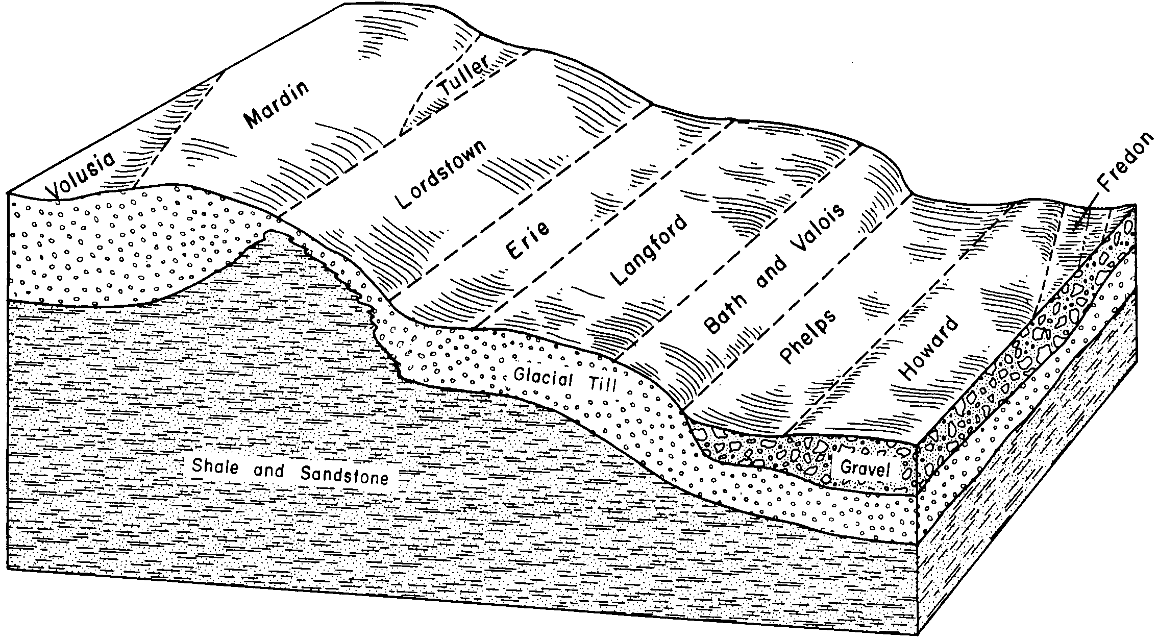
| Langford channery silt loam, 8 to 15 percent slopes | 63C | 5339 | 289669 | 2ywp4 | ny009 | 2002 | 1:24000 |
Langford channery silt loam, 3 to 8 percent slopes | 63B | 2318 | 289668 | 2ywph | ny009 | 2002 | 1:24000 |
Langford channery silt loam, 15 to 25 percent slopes | 63D | 2267 | 289670 | 2ywp6 | ny009 | 2002 | 1:24000 |
Langford channery silt loam, 2 to 8 percent slopes | LgB | 24955 | 289430 | 2ywp2 | ny011 | 1968 | 1:15840 |
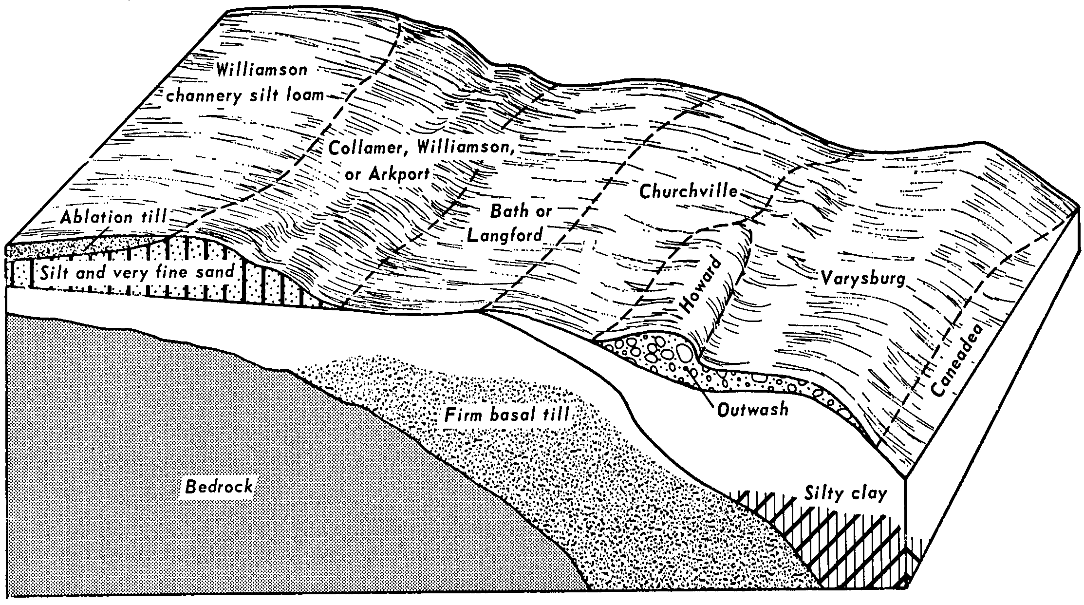
Langford channery silt loam, 8 to 15 percent slopes | LgC | 5283 | 289431 | 2ywp4 | ny011 | 1968 | 1:15840 |
Langford channery silt loam, 15 to 25 percent slopes | LgD | 3104 | 289433 | 2ywp6 | ny011 | 1968 | 1:15840 |
Langford channery silt loam, rolling | LgCK | 2452 | 289432 | 2ywp5 | ny011 | 1968 | 1:15840 |
Langford-Howard complex, 8 to 15 percent slopes | LhC | 1647 | 289435 | 2ywpd | ny011 | 1968 | 1:15840 |
Langford-Howard complex, 25 to 45 percent slopes | LhE | 1493 | 289437 | 2ywpg | ny011 | 1968 | 1:15840 |
Langford channery silt loam, moderately shallow variant, 2 to 8 percent slopes | LnB | 813 | 289438 | 9q5q | ny011 | 1968 | 1:15840 |
Langford-Howard complex, 15 to 25 percent slopes | LhD | 784 | 289436 | 2ywpf | ny011 | 1968 | 1:15840 |
Langford-Howard complex, 2 to 8 percent slopes | LhB | 774 | 289434 | 2ywpc | ny011 | 1968 | 1:15840 |
Langford silt loam, 3 to 8 percent slopes | LnB | 5674 | 289849 | 2ywp7 | ny013 | 1988 | 1:15840 |
Langford silt loam, 8 to 15 percent slopes | LnC | 3861 | 289850 | 2ywp8 | ny013 | 1988 | 1:15840 |
Langford channery silt loam, 3 to 8 percent slopes | LfB | 4372 | 290837 | 2ywph | ny029 | 1979 | 1:15840 |
Langford channery silt loam, 8 to 15 percent slopes | LfC | 2529 | 290838 | 2ywp4 | ny029 | 1979 | 1:15840 |
Langford channery silt loam, silty substratum, 8 to 15 percent slopes | LgC | 2159 | 290840 | 9rmy | ny029 | 1979 | 1:15840 |
Langford channery silt loam, 15 to 25 percent slopes | LfD | 989 | 290839 | 2ywp6 | ny029 | 1979 | 1:15840 |
Langford channery silt loam, silty substratum, 15 to 25 slopes | LgD | 913 | 290841 | 9rmz | ny029 | 1979 | 1:15840 |
Langford channery silt loam, 3 to 8 percent slopes | 63B | 2684 | 3112855 | 2ywph | ny051 | 2019 | 1:24000 |
Langford channery silt loam, 8 to 15 percent slopes | 63C | 2132 | 3112856 | 2ywp4 | ny051 | 2019 | 1:24000 |
Langford channery silt loam, 15 to 25 percent slopes | 63D | 808 | 3112857 | 2ywp6 | ny051 | 2019 | 1:24000 |
Langford channery silt loam, 8 to 15 percent slopes | 63C | 2048 | 2482458 | 2ywp4 | ny069 | 2012 | 1:12000 |
Langford-Erie channery silt loams, 3 to 8 percent slopes | 64B | 1028 | 2504265 | 2wn37 | ny069 | 2012 | 1:12000 |
Langford channery silt loam, 15 to 25 percent slopes | 63D | 608 | 2512416 | 2ywp6 | ny069 | 2012 | 1:12000 |
Langford channery silt loam, 3 to 8 percent slopes | 63B | 28 | 2512413 | 2ywph | ny069 | 2012 | 1:12000 |
Nunda and Langford channery silt loams, 8 to 15 percent slopes | NlC | 1204 | 294530 | 9wgz | ny095 | 1965 | 1:15840 |
Nunda and Langford channery silt loams, 15 to 25 percent slopes | NlD | 729 | 294532 | 9wh1 | ny095 | 1965 | 1:15840 |
Nunda and Langford channery silt loams, 3 to 8 percent slopes | NlB | 407 | 294529 | 9wgy | ny095 | 1965 | 1:15840 |
Nunda and Langford channery silt loams, 8 to 15 percent slopes, eroded | NlC3 | 170 | 294531 | 9wh0 | ny095 | 1965 | 1:15840 |
Langford channery silt loam, 2 to 8 percent slopes | LgB | 4563 | 294735 | 2ywp2 | ny099 | 1966 | 1:15840 |
Langford channery silt loam, 8 to 15 percent slopes, eroded | LgC3 | 624 | 294737 | 2ywpb | ny099 | 1966 | 1:15840 |
Langford channery silt loam, 15 to 25 percent slopes | LgD | 186 | 294738 | 2ywp6 | ny099 | 1966 | 1:15840 |
Langford channery silt loam, 8 to 15 percent slopes | LgC | 178 | 294736 | 2ywp4 | ny099 | 1966 | 1:15840 |
Langford channery silt loam, 2 to 8 percent slopes | LaB | 22042 | 295635 | 2ywp2 | ny109 | 1963 | 1:20000 |
Langford channery silt loam, 8 to 15 percent slopes | LaC | 3005 | 295637 | 2ywp4 | ny109 | 1963 | 1:20000 |
Mardin and Langford soils, 15 to 25 percent slopes | MfD | 1819 | 295660 | 2vckn | ny109 | 1963 | 1:20000 |
Langford channery silt loam, 8 to 15 percent slopes, eroded | LaC3 | 1342 | 295638 | 2ywpb | ny109 | 1963 | 1:20000 |
Langford channery silt loam, 3 to 8 percent slopes, eroded | LaB3 | 712 | 295636 | 2ywp9 | ny109 | 1963 | 1:20000 |
Langford channery silt loam, 3 to 8 percent slopes | LaB | 19821 | 295382 | 2ywph | ny121 | 1969 | 1:20000 |
Langford channery silt loam, 8 to 15 percent slopes | LaC | 8625 | 295383 | 2ywp4 | ny121 | 1969 | 1:20000 |
Langford channery silt loam, 15 to 25 percent slopes | LaD | 1594 | 295384 | 2ywp6 | ny121 | 1969 | 1:20000 |
Langford channery silt loam, 0 to 3 percent slopes | LaA | 1572 | 295381 | 2ywp1 | ny121 | 1969 | 1:20000 |
Langford-Erie channery silt loams, 3 to 8 percent slopes | 64B | 10722 | 1407809 | 2wn37 | ny123 | 1948 | 1:12000 |
Langford channery silt loam, 8 to 15 percent slopes | 63C | 3506 | 1407810 | 2ywp4 | ny123 | 1948 | 1:12000 |
Langford channery silt loam, 3 to 8 percent slopes | 63B | 2744 | 3250403 | 2ywph | ny123 | 1948 | 1:12000 |
Langford channery silt loam, 15 to 25 percent slopes | 63D | 144 | 3250413 | 2ywp6 | ny123 | 1948 | 1:12000 |
