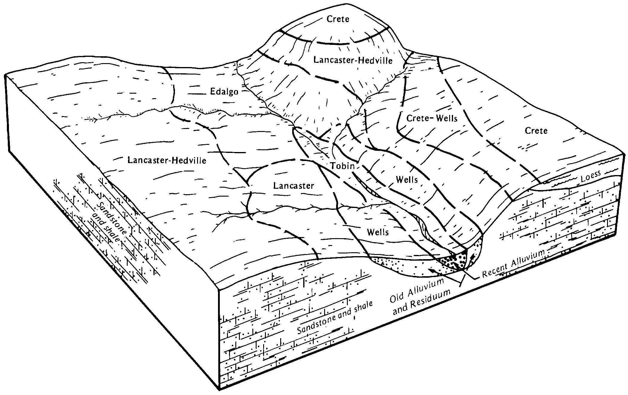
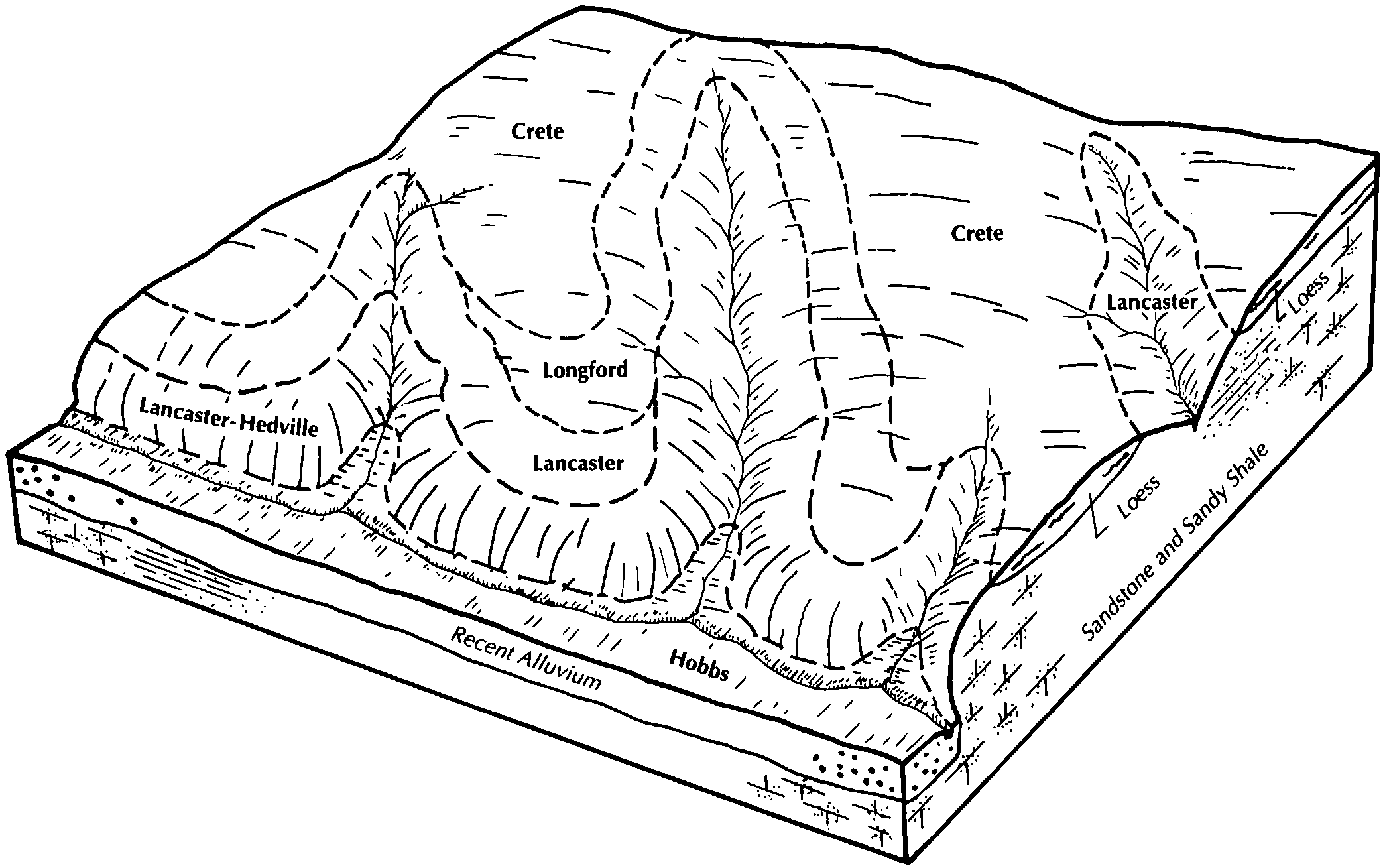
| Lancaster-Hedville complex, 3 to 20 percent slopes | 3396 | 2611 | 2668756 | 2r8yg | ks009 | 1979 | 1:24000 |
Lancaster loam, 1 to 3 percent slopes | 3390 | 9 | 1440471 | 2tpvz | ks009 | 1979 | 1:24000 |
Lancaster-Hedville complex, 3 to 20 percent slopes | 3396 | 23127 | 2668764 | 2r8yg | ks027 | 1983 | 1:24000 |
Lancaster loam, 3 to 7 percent slopes | 3391 | 5243 | 2668763 | 1igwn | ks027 | 1983 | 1:24000 |
Lancaster-Hedville complex, 3 to 20 percent slopes | 3396 | 12177 | 2668767 | 2r8yg | ks029 | 1972 | 1:24000 |
Lancaster loam, 3 to 7 percent slopes | 3391 | 35 | 2668766 | 1igwn | ks029 | 1972 | 1:24000 |
Lancaster-Armo loams, 3 to 7 percent slopes | 3395 | 20 | 1382033 | 2tpw2 | ks029 | 1972 | 1:24000 |
Lancaster-Hedville complex, 3 to 20 percent slopes | 3396 | 2806 | 2668769 | 2r8yj | ks033 | 1987 | 1:24000 |
Lancaster-Hedville complex, 3 to 20 percent slopes | 3396 | 6261 | 2668773 | 2r8yg | ks041 | 1977 | 1:24000 |
Lancaster-Hedville complex, 3 to 20 percent slopes | 3396 | 81146 | 2668777 | 2r8yg | ks053 | 1985 | 1:24000 |
Lancaster loam, 3 to 7 percent slopes, eroded | 3392 | 86 | 1382220 | 2tpw0 | ks053 | 1985 | 1:24000 |
Lancaster loam, 1 to 3 percent slopes | 3390 | 46 | 1382219 | 2tpvz | ks053 | 1985 | 1:24000 |
Lancaster-Hedville complex, 3 to 20 percent slopes | 3396 | 5589 | 2668782 | 2r8yj | ks097 | 1983 | 1:24000 |
Lancaster-Hedville complex, 3 to 20 percent slopes | 3396 | 41598 | 2668784 | 2r8yg | ks105 | 1983 | 1:24000 |
Geary-Lancaster complex, 5 to 10 percent slopes | 3852 | 38809 | 2733336 | 2r9d2 | ks105 | 1983 | 1:24000 |
Lancaster loam, 3 to 7 percent slopes | 3391 | 1175 | 2668783 | 1igwn | ks105 | 1983 | 1:24000 |
Lancaster-Armo loams, 3 to 7 percent slopes | 3395 | 160 | 1382093 | 2tpw2 | ks105 | 1983 | 1:24000 |
Lancaster-Hedville complex, 3 to 20 percent slopes | 3396 | 62502 | 2668794 | 2r8yg | ks113 | 1980 | 1:24000 |
Lancaster loam, 3 to 7 percent slopes | 3391 | 10431 | 2668793 | 1igwn | ks113 | 1980 | 1:24000 |
Lancaster loam, 1 to 3 percent slopes | 3390 | 18 | 1429206 | 2tpvz | ks113 | 1980 | 1:24000 |
Lancaster loam, 3 to 7 percent slopes | 3391 | 11167 | 2668790 | 1igwn | ks115 | 1981 | 1:24000 |
Lancaster-Hedville complex, 3 to 20 percent slopes | 3396 | 7064 | 2668791 | 2r8yg | ks115 | 1981 | 1:24000 |
Lancaster loam, 1 to 3 percent slopes | 3390 | 5963 | 1382787 | 2tpvz | ks115 | 1981 | 1:24000 |
Lancaster-Armo loams, 3 to 7 percent slopes | 3395 | 1837 | 1381983 | 2tpw2 | ks123 | 1977 | 1:24000 |
Lancaster-Hedville complex, 3 to 20 percent slopes | 3396 | 1654 | 2668796 | 2r8yg | ks123 | 1977 | 1:24000 |
Geary-Lancaster complex, 5 to 10 percent slopes | 3852 | 285 | 2733344 | 2r9d2 | ks123 | 1977 | 1:24000 |
Lancaster loam, 3 to 7 percent slopes | 3391 | 63 | 2668795 | 1igwn | ks123 | 1977 | 1:24000 |
Lancaster loam, 3 to 7 percent slopes | 3391 | 9960 | 2668804 | 1igwn | ks143 | 1978 | 1:24000 |
Lancaster-Hedville complex, 3 to 20 percent slopes | 3396 | 7856 | 2668805 | 2r8yg | ks143 | 1978 | 1:24000 |
Lancaster-Hedville complex, 3 to 20 percent slopes | 3396 | 4753 | 2668807 | 2r8yg | ks157 | 1965 | 1:24000 |
Lancaster loam, 3 to 7 percent slopes | 3391 | 92 | 2668806 | 1igwn | ks157 | 1965 | 1:24000 |
Lancaster loam, 1 to 3 percent slopes | 3390 | 5632 | 1433232 | 2tpvz | ks159 | 1971 | 1:24000 |
Hedville-Lancaster complex, 5 to 20 percent slopes | 3381 | 5055 | 1433231 | 2ww0m | ks159 | 1971 | 1:24000 |
Lancaster-Hedville complex, 3 to 20 percent slopes | 3396 | 4352 | 2668809 | 2r8yg | ks159 | 1971 | 1:24000 |
Lancaster loam, 3 to 7 percent slopes, eroded | 3392 | 2353 | 1433234 | 2tpw0 | ks159 | 1971 | 1:24000 |
Lancaster loam, 3 to 7 percent slopes | 3391 | 49 | 2668808 | 1igwn | ks159 | 1971 | 1:24000 |
Lancaster loam, 3 to 7 percent slopes | 3391 | 4 | 2668811 | 1igwn | ks161 | 1970 | 1:24000 |
Lancaster-Hedville complex, 3 to 20 percent slopes | 3396 | 20149 | 2668813 | 2r8yg | ks167 | 1980 | 1:24000 |
Lancaster loam, 3 to 7 percent slopes | 3391 | 1785 | 2668812 | 1igwn | ks167 | 1980 | 1:24000 |
Lancaster-Hedville complex, 3 to 20 percent slopes | 3396 | 92370 | 2668815 | 2r8yg | ks169 | 1989 | 1:24000 |
Lancaster loam, 3 to 7 percent slopes | 3391 | 8263 | 2668814 | 1igwn | ks169 | 1989 | 1:24000 |
Lancaster-Hedville complex, 3 to 20 percent slopes | 3396 | 47141 | 2668824 | 2r8yg | ks201 | 1988 | 1:24000 |
Lancaster loam, 3 to 7 percent slopes | 3391 | 19610 | 2668823 | 1igwn | ks201 | 1988 | 1:24000 |
Lancaster loam, 7 to 11 percent slopes | 4173 | 322 | 1691112 | 2tpw6 | ne067 | 2000 | 1:12000 |
Lancaster loam, 3 to 7 percent slopes | 3391 | 243 | 2668744 | 1igwn | ne067 | 2000 | 1:12000 |
Lancaster and Edalgo soils, 11 to 30 percent slopes | 4170 | 11696 | 1691816 | 2tpw5 | ne095 | 1970 | 1:20000 |
Lancaster loam, 3 to 7 percent slopes, eroded | 3392 | 3428 | 1691814 | 2tpw1 | ne095 | 1970 | 1:20000 |
Lancaster loam, 7 to 11 percent slopes | 4173 | 2402 | 1691815 | 2tpw6 | ne095 | 1970 | 1:20000 |
Lancaster soils, 7 to 11 percent slopes, severely eroded | 4175 | 1890 | 1691813 | 1tsgm | ne095 | 1970 | 1:20000 |
Lancaster loam, 7 to 16 percent slopes, severely eroded | 4174 | 218 | 1692431 | 1tt3k | ne169 | 1965 | 1:20000 |
Lancaster soils, 7 to 11 percent slopes, severely eroded | 4175 | 47 | 2218738 | 2dgs6 | ne169 | 1965 | 1:20000 |