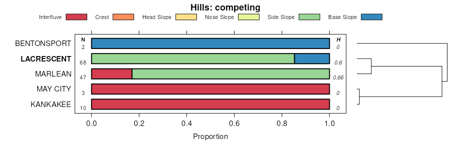
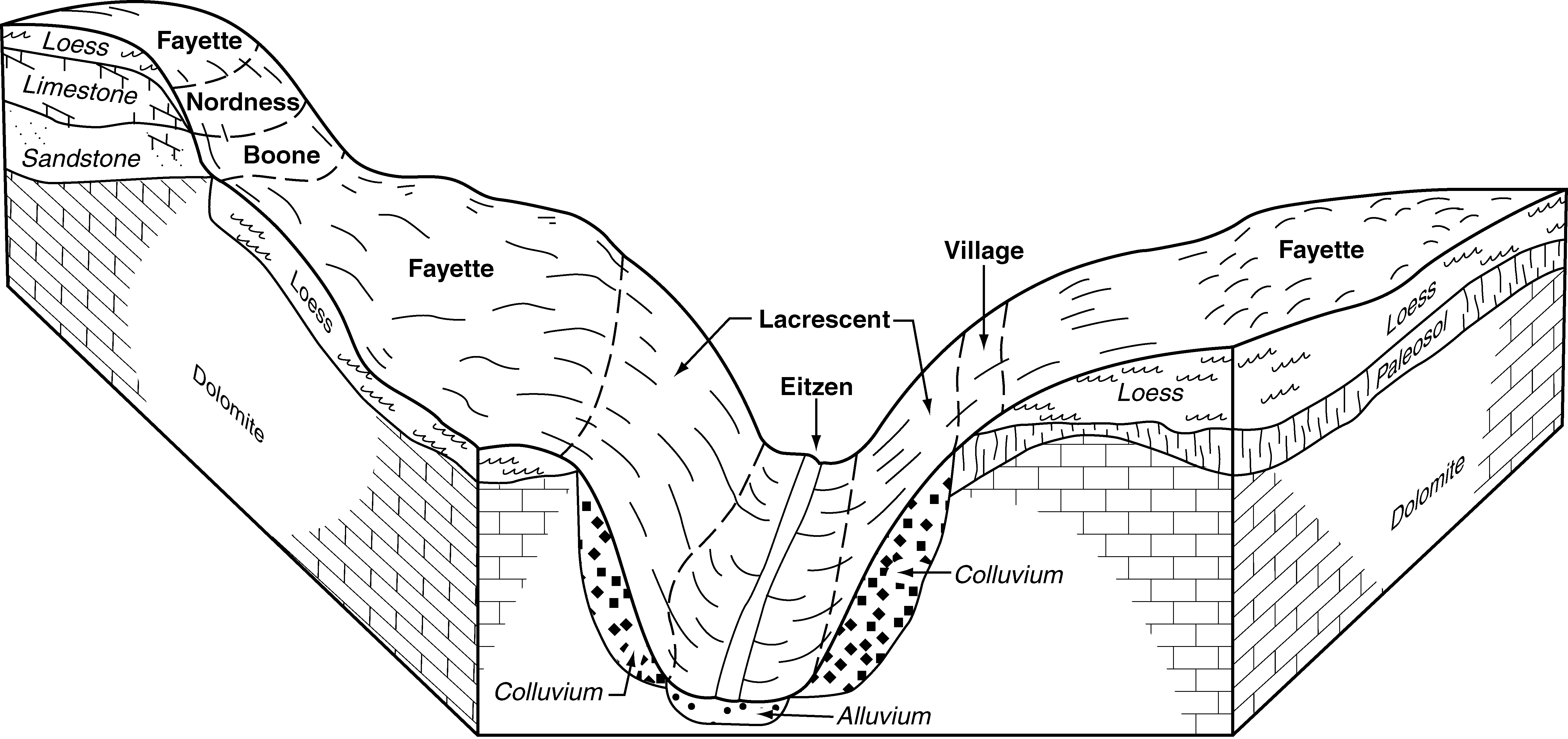
| Lacrescent silt loam, 25 to 70 percent slopes | 840G | 51996 | 402566 | fhx0 | ia005 | 1992 | 1:15840 |
Lacrescent silt loam, 18 to 25 percent slopes | 840F | 746 | 402565 | fhwz | ia005 | 1992 | 1:15840 |
Lacrescent silt loam, 14 to 18 percent slopes | 840E | 178 | 402564 | fhwy | ia005 | 1992 | 1:15840 |
Dorerton-Lacrescent complex, 18 to 60 percent slopes | 799G | 4627 | 407561 | fp34 | ia097 | 1988 | 1:15840 |
Lacrescent cobbly silty clay loam, 18 to 45 percent slopes | 840G | 17652 | 1400309 | 1j048 | ia191 | 2005 | 1:12000 |
Lacrescent cobbly silty clay loam, 5 to 18 percent slopes | 840E | 71 | 1429109 | 1jz39 | ia191 | 2005 | 1:12000 |
Lacrescent channery silt loam, 35 to 60 percent slopes | 785G | 1247 | 2378660 | 2kv5z | il001 | 1997 | 1:12000 |
Lacrescent channery silt loam, 35 to 60 percent slopes | 785G | 712 | 2542041 | 2qrb1 | il013 | 1986 | 1:15840 |
Lacrescent cobbly loam, 25 to 60 percent slopes | 785G | 48 | 995997 | 12fdy | il015 | 2005 | 1:12000 |
Lacrescent channery silt loam, 35 to 60 percent slopes | 785G | 829 | 211785 | 73cs | il061 | 1968 | 1:15840 |
Hamburg-Lacrescent complex, 35 to 60 percent slopes | 836G | 382 | 2542257 | 2qxs0 | il061 | 1968 | 1:15840 |
Lacrescent channery silt loam, 35 to 60 percent slopes | 785G | 1558 | 175216 | 5wb4 | il067 | 1993 | 1:15840 |
Lacrescent silt loam, 5 to 10 percent slopes | 785C | 160 | 175215 | 5wb3 | il067 | 1993 | 1:15840 |
Rock outcrop, limestone-Lacrescent complex, 35 to 60 percent slopes | 837G | 996 | 728474 | sg15 | il083 | 2002 | 1:12000 |
Hamburg-Lacrescent complex, 35 to 60 percent slopes | 836G | 856 | 728473 | sg14 | il083 | 2002 | 1:12000 |
Lacrescent cobbly silt loam, 35 to 60 percent slopes | 785G | 18983 | 2229443 | 2dtxj | il085 | 1990 | 1:12000 |
Lacrescent cobbly silt loam, 18 to 35 percent slopes | 785F | 9534 | 2229445 | 2dtxl | il085 | 1990 | 1:12000 |
Lacrescent flaggy silt loam, 35 to 70 percent slopes | 785G | 644 | 184116 | 65l7 | il133 | 1998 | 1:12000 |
Lacrescent channery silt loam, 35 to 60 percent slopes | 785G | 612 | 201313 | 6rgz | il149 | 2001 | 1:12000 |
Lacrescent cobbly loam, 25 to 60 percent slopes | 785G | 671 | 793093 | vm8n | il195 | 2003 | 1:12000 |
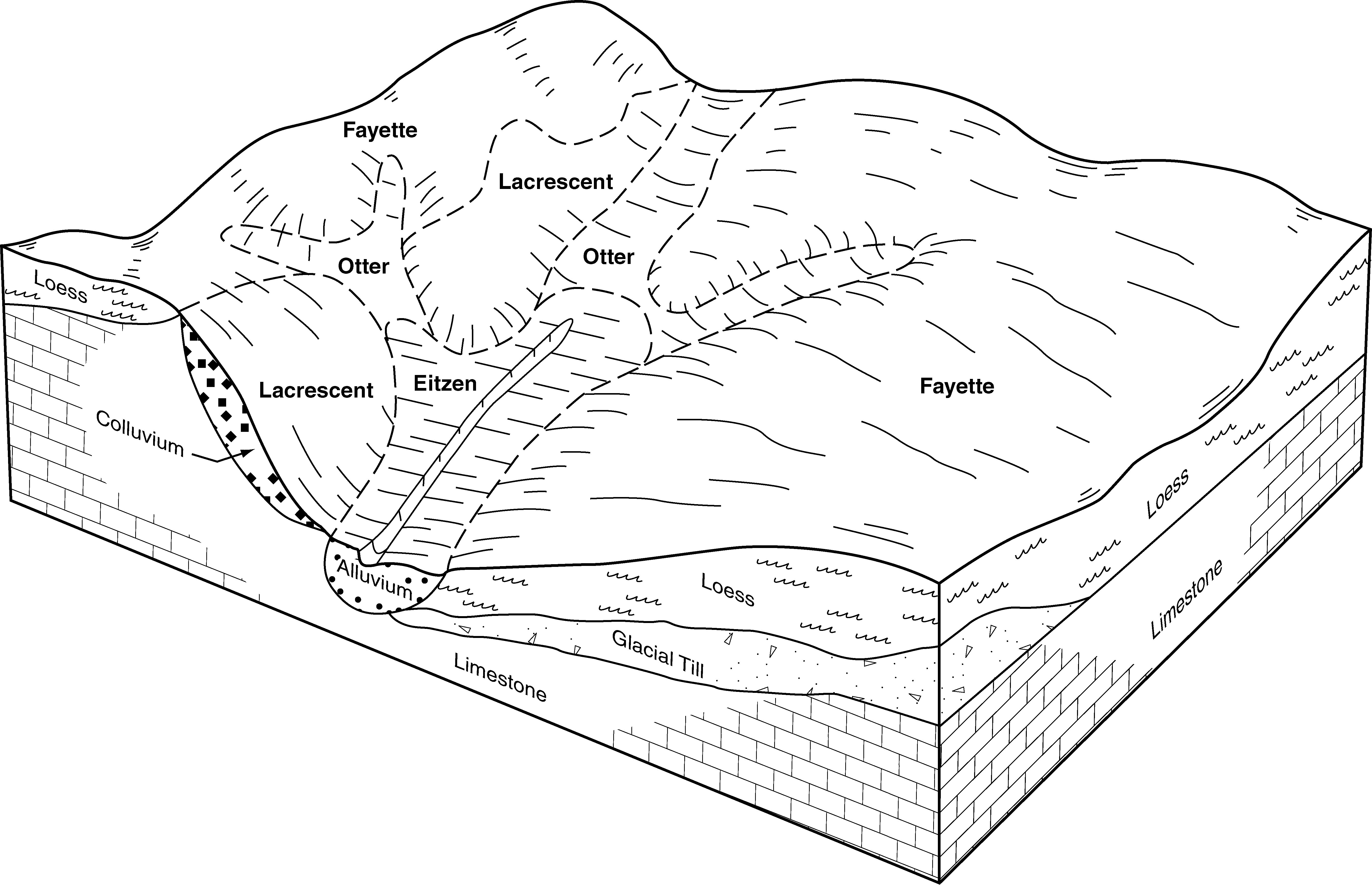
Frontenac-Lacrescent complex, 30 to 70 percent slopes, rocky | N639G | 21124 | 2372351 | 2kmmg | mn045 | 2008 | 1:12000 |
Frontenac-Lacrescent complex, 20 to 45 percent slopes, rocky | N639F | 9172 | 2372349 | 2kmmd | mn045 | 2008 | 1:12000 |
Lacrescent, flaggy-Frontenac-Rock outcrop complex, 45 to 90 percent slopes | N640G | 1478 | 2375814 | 2kr75 | mn045 | 2008 | 1:12000 |
Frontenac-Lacrescent complex, 30 to 70 percent slopes, rocky | N639G | 16308 | 1713087 | 1vhlw | mn049 | 2007 | 1:12000 |
Frontenac-Lacrescent complex, 20 to 45 percent slopes, rocky | N639F | 4045 | 1713084 | 1vhls | mn049 | 2007 | 1:12000 |
Lacrescent, flaggy-Frontenac-Rock outcrop complex, 45 to 90 percent slopes | N640G | 778 | 1713086 | 1vhlv | mn049 | 2007 | 1:12000 |
Lacrescent cobbly silty clay loam, 45 to 70 percent slopes | 457G | 27444 | 398281 | fcfs | mn055 | 1981 | 1:15840 |
Lacrescent flaggy silt loam, 20 to 35 percent slopes | 457E | 1283 | 398280 | fcfr | mn055 | 1981 | 1:15840 |
Frontenac-Lacrescent complex, 30 to 70 percent slopes, rocky | N639G | 32528 | 2216212 | 2dd4q | mn157 | 2008 | 1:12000 |
Frontenac-Lacrescent complex, 20 to 45 percent slopes, rocky | N639F | 4175 | 2216209 | 2dd4m | mn157 | 2008 | 1:12000 |
Lacrescent, flaggy-Frontenac-Rock outcrop complex, 45 to 90 percent slopes | N640G | 1527 | 2216210 | 2dd4n | mn157 | 2008 | 1:12000 |
Lacrescent silt loam, rocky, 45 to 70 percent slopes | 457G | 40658 | 429052 | gdgd | mn169 | 1987 | 1:20000 |
Lacrescent-Rock outcrop complex, 45 to 70 percent slopes | 832G | 2775 | 429098 | gdhw | mn169 | 1987 | 1:20000 |
Lacrescent-Rock outcrop complex, 30 to 45 percent slopes | 832F | 1209 | 429097 | gdhv | mn169 | 1987 | 1:20000 |
Lacrescent channery silt loam, 20 to 45 percent slopes | 457E | 1028 | 429051 | gdgc | mn169 | 1987 | 1:20000 |
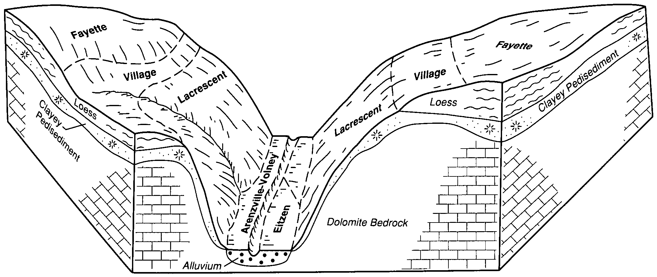
Lacrescent-Dunbarton complex, very stony, 30 to 60 percent slopes | 1130F | 5908 | 2495357 | 2lk96 | wi023 | 1960 | 1:12000 |
Lacrescent-Dunbarton complex, very stony, 30 to 60 percent slopes | 1130F | 1149 | 2809841 | 2lk96 | wi025 | 1972 | 1:15840 |
Lacrescent-Dunbarton complex, very stony, 30 to 60 percent slopes | 1130F | 40553 | 2809831 | 2lk96 | wi043 | 1959 | 1:20000 |
Brodale, deep-Lacrescent, very stony-Rock outcrop complex, 60 to 90 percent slopes | 1150G | 3344 | 3119023 | 2xvsj | wi043 | 1959 | 1:20000 |
Lacrescent-Dunbarton complex, very stony, 30 to 60 percent slopes | 1130F | 2575 | 2809847 | 2lk96 | wi045 | 1969 | 1:12000 |
Lacrescent-Dunbarton complex, very stony, 30 to 60 percent slopes | 1130F | 12746 | 2561807 | 2lk96 | wi049 | 1960 | 1:20000 |
Lacrescent-Dunbarton complex, very stony, 30 to 60 percent slopes | 1130F | 2416 | 2561808 | 2lk96 | wi065 | 1964 | 1:15840 |
Lacrescent-Dunbarton complex, 20 to 30 percent slopes, very stony | 1130E | 669 | 2809837 | 2sb85 | wi065 | 1964 | 1:15840 |
Lacrescent-Dunbarton complex, very stony, 30 to 60 percent slopes | 1130F | 761 | 2495358 | 2lk96 | wi123 | 1965 | 1:12000 |