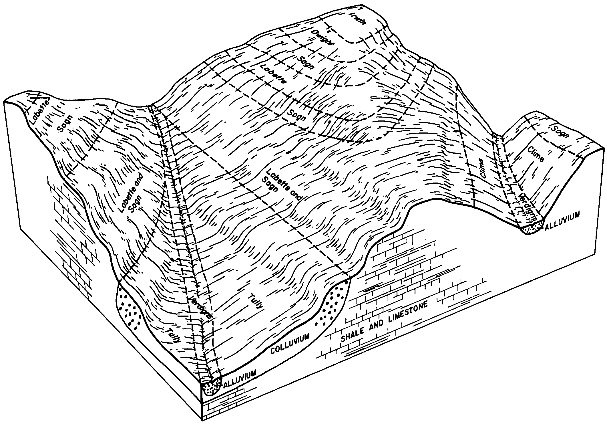
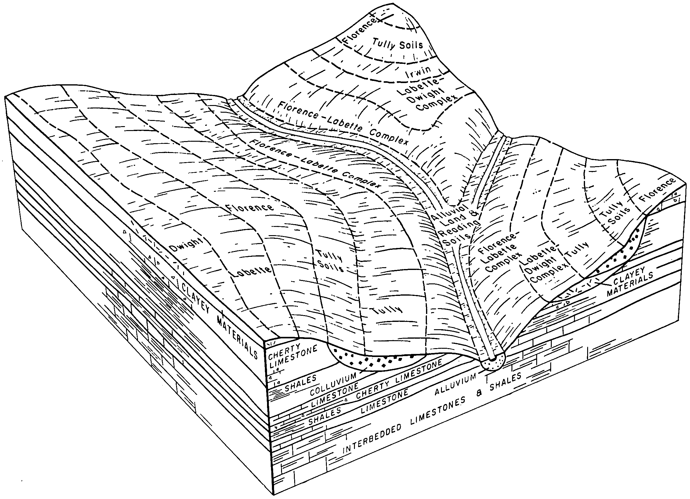
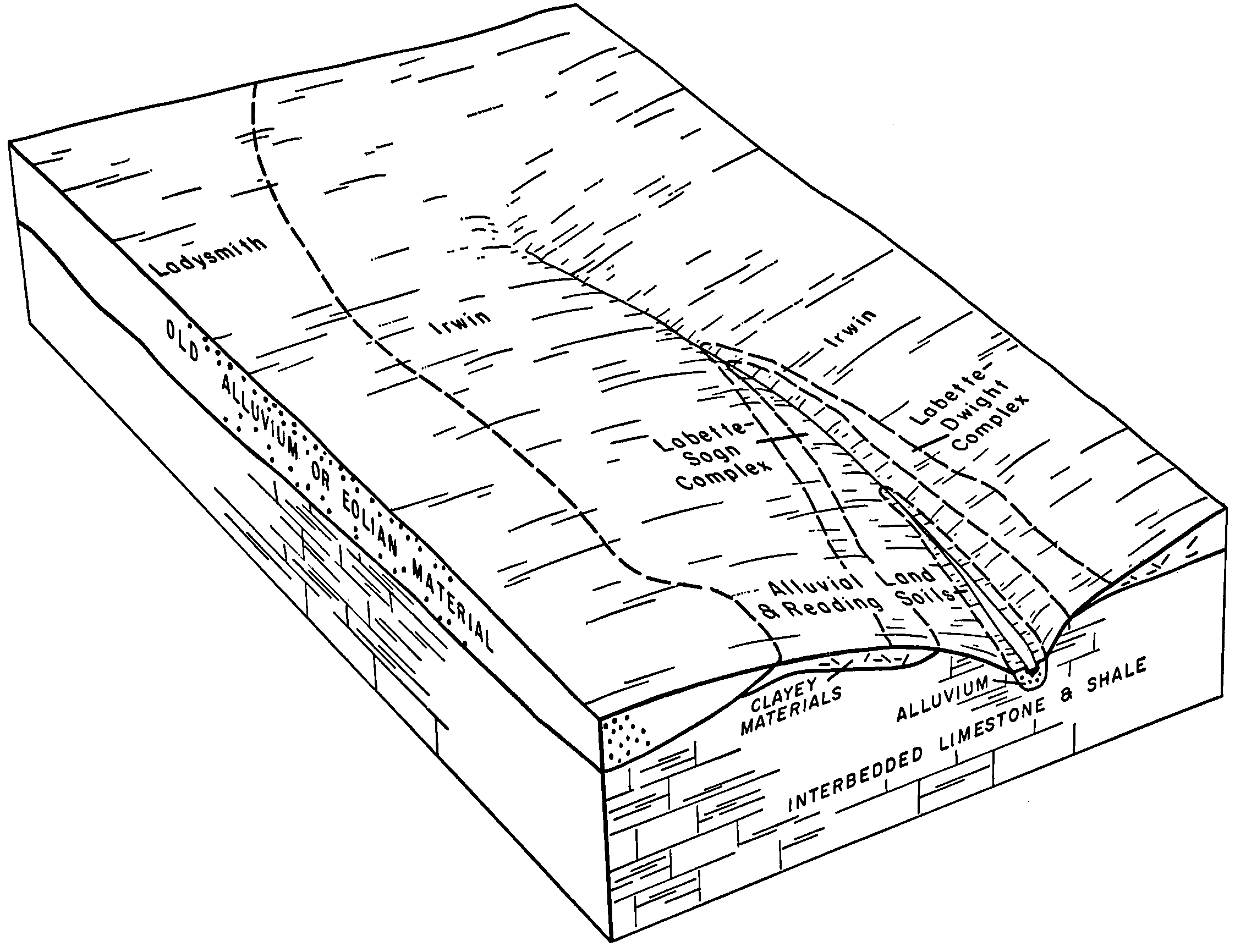
| Labette-Dwight complex, 0 to 3 percent slopes | 4744 | 102966 | 2605795 | 2r8yc | ks015 | 1970 | 1:24000 |
Labette-Sogn silty clay loam, 0 to 8 percent slopes | 4746 | 49178 | 2733309 | 1igwr | ks015 | 1970 | 1:24000 |
Labette silty clay loam, 1 to 3 percent slopes | 4740 | 36712 | 2668757 | 1igwp | ks015 | 1970 | 1:24000 |
Benfield-Labette cherty silty clay loams, 2 to 12 percent slopes | 4535 | 28124 | 1382856 | 2ww07 | ks015 | 1970 | 1:24000 |
Labette silty clay loam, 3 to 7 percent slopes | 4742 | 8142 | 2668758 | 1igwq | ks015 | 1970 | 1:24000 |
Florence-Labette complex, 2 to 12 percent slopes | 4655 | 1966 | 1382868 | 2tt4m | ks015 | 1970 | 1:24000 |
Labette silty clay loam, 1 to 3 percent slopes, eroded | 4741 | 1430 | 1382884 | 2xlgm | ks015 | 1970 | 1:24000 |
Labette-Sogn silty clay loam, 0 to 8 percent slopes | 4746 | 59775 | 2733310 | 1igwr | ks017 | 1967 | 1:24000 |
Florence-Labette complex, 2 to 12 percent slopes | 4655 | 36821 | 1382821 | 2tt4m | ks017 | 1967 | 1:24000 |
Labette-Dwight complex, 0 to 3 percent slopes | 4744 | 29108 | 2605796 | 2r8yc | ks017 | 1967 | 1:24000 |
Labette silty clay loam, 1 to 3 percent slopes | 4740 | 10212 | 2668759 | 1igwp | ks017 | 1967 | 1:24000 |
Labette silty clay loam, 3 to 7 percent slopes | 4742 | 2109 | 2668760 | 1igwq | ks017 | 1967 | 1:24000 |
Labette silty clay loam, 3 to 7 percent slopes, eroded | 4743 | 1478 | 1382829 | 2xlgn | ks017 | 1967 | 1:24000 |
Labette silty clay loam, 1 to 3 percent slopes | 4740 | 708 | 2668761 | 1igwp | ks019 | 1972 | 1:24000 |
Labette-Dwight complex, 0 to 3 percent slopes | 4744 | 337 | 2605797 | 2r8yc | ks019 | 1972 | 1:24000 |
Labette silty clay loam, 1 to 3 percent slopes | 4740 | 12 | 2668768 | 1igwp | ks031 | 1980 | 1:24000 |
Labette-Sogn silty clay loam, 0 to 8 percent slopes | 4746 | 59288 | 2733320 | 1igwr | ks035 | 1977 | 1:24000 |
Labette-Dwight complex, 0 to 3 percent slopes | 4744 | 32062 | 2605798 | 2r8yc | ks035 | 1977 | 1:24000 |
Labette silty clay loam, 1 to 3 percent slopes | 4740 | 31004 | 2668771 | 1igwp | ks035 | 1977 | 1:24000 |
Labette silty clay loam, 3 to 7 percent slopes | 4742 | 7858 | 2668772 | 1igwq | ks035 | 1977 | 1:24000 |
Labette silty clay loam, 3 to 7 percent slopes, eroded | 4743 | 2114 | 1382937 | 2xlgn | ks035 | 1977 | 1:24000 |
Labette-Sogn silty clay loam, 0 to 8 percent slopes | 4746 | 15298 | 2733322 | 1igwr | ks049 | 1984 | 1:24000 |
Labette-Dwight complex, 0 to 3 percent slopes | 4744 | 11119 | 2605799 | 2r8yc | ks049 | 1984 | 1:24000 |
Labette silty clay loam, 1 to 3 percent slopes | 4740 | 1008 | 2668775 | 1igwp | ks049 | 1984 | 1:24000 |
Labette-Sogn silty clay loam, 0 to 8 percent slopes | 4746 | 45090 | 2733327 | 1igwr | ks073 | 1981 | 1:24000 |
Labette silty clay loam, 1 to 3 percent slopes | 4740 | 31826 | 2668779 | 1igwp | ks073 | 1981 | 1:24000 |
Labette-Dwight complex, 0 to 3 percent slopes | 4744 | 31095 | 2605800 | 2r8yc | ks073 | 1981 | 1:24000 |
Florence-Labette complex, 2 to 12 percent slopes | 4655 | 18839 | 1453646 | 2tt4m | ks073 | 1981 | 1:24000 |
Labette-Dwight complex, 0 to 3 percent slopes | 4744 | 13771 | 2605801 | 2r8yc | ks111 | 1977 | 1:24000 |
Labette silty clay loam, 1 to 3 percent slopes | 4740 | 13504 | 2668785 | 1igwp | ks111 | 1977 | 1:24000 |
Florence-Labette complex, 2 to 12 percent slopes | 4655 | 11181 | 1453706 | 2tt4m | ks111 | 1977 | 1:24000 |
Labette silty clay loam, 3 to 7 percent slopes, eroded | 4743 | 2436 | 1453713 | 2xlgn | ks111 | 1977 | 1:24000 |
Labette silty clay loam, 3 to 7 percent slopes | 4742 | 1794 | 2668787 | 1igwq | ks111 | 1977 | 1:24000 |
Labette-Sogn silty clay loam, 0 to 8 percent slopes | 4746 | 20767 | 2733340 | 1igwr | ks115 | 1981 | 1:24000 |
Labette-Dwight complex, 0 to 3 percent slopes | 4744 | 13517 | 2605802 | 2r8yc | ks115 | 1981 | 1:24000 |
Labette silty clay loam, 1 to 3 percent slopes | 4740 | 13053 | 2668788 | 1igwp | ks115 | 1981 | 1:24000 |
Labette-Dwight complex, 0 to 3 percent slopes | 4744 | 64144 | 2605803 | 2r8yc | ks127 | 1970 | 1:24000 |
Florence-Labette complex, 2 to 12 percent slopes | 4655 | 26332 | 1454498 | 2tt4m | ks127 | 1970 | 1:24000 |
Labette-Sogn silty clay loam, 0 to 8 percent slopes | 4746 | 14522 | 2733345 | 1igwr | ks127 | 1970 | 1:24000 |
Labette silty clay loam, 3 to 7 percent slopes | 4742 | 10515 | 2668799 | 1igwq | ks127 | 1970 | 1:24000 |
Labette silty clay loam, 1 to 3 percent slopes | 4740 | 146 | 2668797 | 1igwp | ks127 | 1970 | 1:24000 |
Labette silty clay loam, 1 to 3 percent slopes | 4740 | 470 | 2668801 | 1igwp | ks139 | 1983 | 1:24000 |
Labette silty clay loam, 3 to 7 percent slopes | 4742 | 194 | 2668803 | 1igwq | ks139 | 1983 | 1:24000 |
Labette silty clay loam, 3 to 7 percent slopes, eroded | 4743 | 15 | 1454761 | 2xlgn | ks139 | 1983 | 1:24000 |
Florence-Labette complex, 2 to 12 percent slopes | 4655 | 731 | 1472311 | 2tt4m | ks161 | 1970 | 1:24000 |
Labette silty clay loam, 3 to 7 percent slopes | 4742 | 8196 | 2668817 | 1igwq | ks177 | 1966 | 1:24000 |
Labette silty clay loam, 1 to 3 percent slopes | 4740 | 6371 | 2668816 | 1igwp | ks177 | 1966 | 1:24000 |
Labette silty clay loam, 3 to 7 percent slopes, eroded | 4743 | 1649 | 1473461 | 2xlgn | ks177 | 1966 | 1:24000 |
Florence-Labette complex, 2 to 12 percent slopes | 4655 | 53190 | 1472142 | 2tt4m | ks197 | 1988 | 1:24000 |
Labette silty clay loam, 3 to 7 percent slopes | 4742 | 9052 | 2668822 | 1igwq | ks197 | 1988 | 1:24000 |
Labette silty clay loam, 1 to 3 percent slopes | 4740 | 7 | 2668820 | 1igwp | ks197 | 1988 | 1:24000 |
Labette-Dwight complex, 0 to 3 percent slopes | 4744 | 161 | 2605804 | 2r8yc | ks207 | 1973 | 1:20000 |
Labette silty clay loam, 1 to 3 percent slopes | 4740 | 11 | 2668826 | 1igwp | ks207 | 1973 | 1:20000 |