| Kyle silty clay, 4 to 7 percent slopes | Kn | 8150 | 345751 | cls8 | mt111 | 1966 | 1:20000 |
Kyle silty clay, 1 to 4 percent slopes | Km | 5416 | 345750 | cls7 | mt111 | 1966 | 1:20000 |
Kyle silty clay, 0 to 1 percent slopes | Kl | 2472 | 345749 | cls6 | mt111 | 1966 | 1:20000 |
Kyle silty clay, 0 to 2 percent slopes | Ks | 22471 | 346030 | cm28 | mt607 | 1970 | 1:24000 |
Kyle silty clay, 4 to 8 percent slopes | Ku | 5272 | 346032 | cm2b | mt607 | 1970 | 1:24000 |
Kyle gravelly silty clay, 8 to 15 percent slopes | KV | 4867 | 346018 | cm1w | mt607 | 1970 | 1:24000 |
Kyle clay, saline | Kw | 4558 | 346033 | cm2c | mt607 | 1970 | 1:24000 |
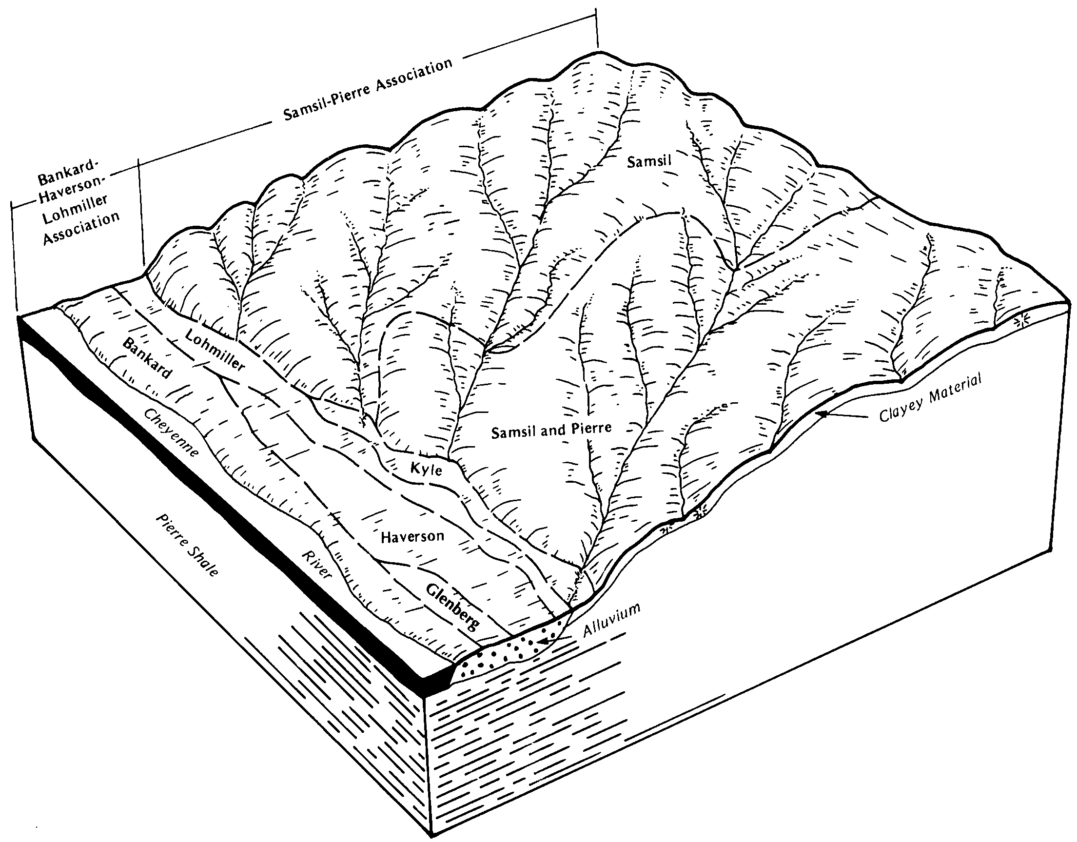
Pierre-Kyle clays, gently undulating | Pk | 3662 | 2428546 | 2mj36 | mt607 | 1970 | 1:24000 |
Kyle silty clay, 2 to 4 percent slopes | Kt | 2565 | 346031 | cm29 | mt607 | 1970 | 1:24000 |
Kyle clay, 0 to 2 percent slopes | Kc | 3095 | 347076 | cn50 | mt611 | 1971 | 1:24000 |
Kyle clay, 4 to 8 percent slopes | Ke | 2906 | 347078 | cn52 | mt611 | 1971 | 1:24000 |
Kyle clay, 2 to 4 percent slopes | Kd | 2229 | 347077 | cn51 | mt611 | 1971 | 1:24000 |
Kyle clay, 8 to 15 percent slopes | Kf | 1582 | 347079 | cn53 | mt611 | 1971 | 1:24000 |
Kyle clay, 8 to 15 percent slopes | Kn | 6090 | 347886 | cp04 | mt643 | 1967 | 1:20000 |
Kyle clay, 4 to 8 percent slopes | Km | 1775 | 347885 | cp03 | mt643 | 1967 | 1:20000 |
Kyle clay, 2 to 4 percent slopes | Kl | 272 | 347884 | cp02 | mt643 | 1967 | 1:20000 |
Kyle silty clay, 2 to 6 percent slopes | 5359 | 39002 | 358122 | 2tnmc | ne045 | 1973 | 1:20000 |
Kyle-Hisle complex, 0 to 2 percent slopes | 5360 | 7226 | 358123 | d0nc | ne045 | 1973 | 1:20000 |
Kyle silty clay, 0 to 2 percent slopes | 5358 | 5987 | 358121 | 2tnmb | ne045 | 1973 | 1:20000 |
Kyle silty clay, 2 to 6 percent slopes | 5359 | 7419 | 357930 | 2tnmc | ne165 | 1993 | 1:20000 |
Kyle silty clay, 0 to 2 percent slopes | 5358 | 2882 | 357929 | 2tnmb | ne165 | 1993 | 1:20000 |
Kyle clay, 2 to 6 percent slopes | KlB | 29517 | 2768039 | 2rd41 | sd019 | 1970 | 1:24000 |
Kyle clay, terrace | Kt | 17745 | 353189 | cvj6 | sd019 | 1970 | 1:24000 |
Kyle-Pierre clays, 0 to 6 percent slopes | KuB | 17132 | 353190 | 30wnb | sd019 | 1970 | 1:24000 |
Kyle clay, 0 to 2 percent slopes | KlA | 11553 | 2768038 | 2rd40 | sd019 | 1970 | 1:24000 |
Kyle clay, 6 to 9 percent slopes | KlC | 616 | 2768040 | 2rd42 | sd019 | 1970 | 1:24000 |
Kyle clay, moist, 2 to 6 percent slopes | P186B | 383 | 2668875 | 2qt3h | sd019 | 1970 | 1:24000 |
Kyle clay, moist, 6 to 9 percent slopes | P186C | 174 | 2668876 | 2qt3j | sd019 | 1970 | 1:24000 |
Kyle clay, 2 to 6 percent slopes | KyB | 26481 | 2768046 | 2rd41 | sd047 | 1980 | 1:24000 |
Kyle clay, 0 to 2 percent slopes | KyA | 23067 | 2768045 | 2rd40 | sd047 | 1980 | 1:24000 |
Kyle clay, 3 to 6 percent slopes | KyB | 3259 | 354106 | cwgs | sd055 | 1992 | 1:24000 |
Kyle clay, 0 to 3 percent slopes | KyA | 1677 | 354105 | cwgr | sd055 | 1992 | 1:24000 |
Kyle clay, 2 to 6 percent slopes | KyB | 819 | 2768048 | 2rd41 | sd063 | 1984 | 1:24000 |
Kyle clay, 2 to 6 percent slopes | 614B | 2007 | 2768051 | 2rd41 | sd081 | 2007 | 1:24000 |
Kyle clay, 0 to 2 percent slopes | 614A | 633 | 2768050 | 2rd40 | sd081 | 2007 | 1:24000 |
Kyle clay, moist, 2 to 6 percent slopes | P186B | 118 | 2733294 | 2qt3h | sd081 | 2007 | 1:24000 |
Kyle clay | Ky | 4148 | 353384 | cvqh | sd095 | 1971 | 1:20000 |
Kyle clay, 2 to 6 percent slopes | KyB | 24960 | 355852 | cy93 | sd137 | 1985 | 1:24000 |
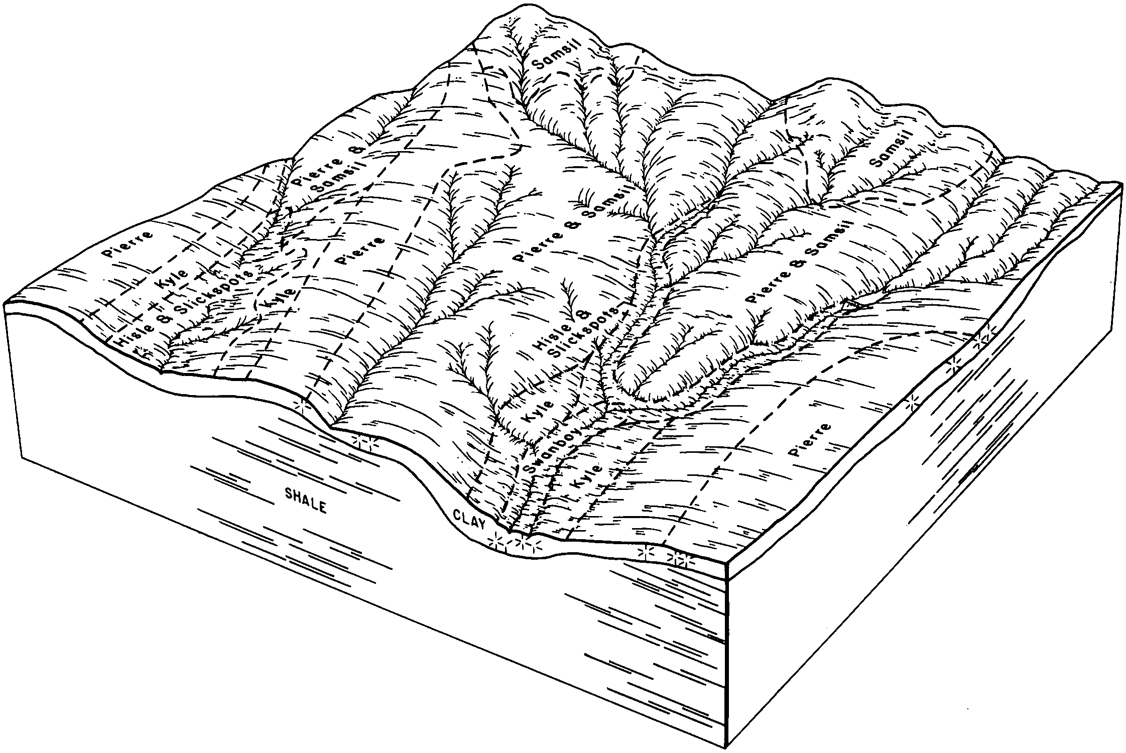
Swanboy-Kyle clays, 2 to 15 percent slopes | SxC | 2711 | 355896 | cybj | sd137 | 1985 | 1:24000 |
Kyle clay, 2 to 6 percent slopes | KbB | 50062 | 2768058 | 2rd41 | sd600 | 1974 | 1:24000 |
Kyle clay, 0 to 2 percent slopes | KbA | 19307 | 2768057 | 2rd40 | sd600 | 1974 | 1:24000 |
Kyle soils, 2 to 6 percent slopes, mounded | KcB | 5531 | 354322 | cwpr | sd600 | 1974 | 1:24000 |
Kyle clay, moist, 2 to 6 percent slopes | P186B | 431 | 2733425 | 2qt3h | sd600 | 1974 | 1:24000 |
Kyle clay, 2 to 6 percent slopes | KyB | 10970 | 2768062 | 2rd41 | sd601 | 1983 | 1:24000 |
Kyle clay, 0 to 2 percent slopes | KyA | 3119 | 2768061 | 2rd40 | sd601 | 1983 | 1:24000 |
Kyle clay, 2 to 6 percent slopes | KyB | 25462 | 2768068 | 2rd41 | sd606 | 2011 | 1:24000 |
Kyle clay, 0 to 2 percent slopes | KyA | 18735 | 2768067 | 2rd40 | sd606 | 2011 | 1:24000 |
Kyle clay, 6 to 9 percent slopes | KyC | 7505 | 2768069 | 2rd42 | sd606 | 2011 | 1:24000 |
Kyle clay, 0 to 1 percent slopes | KtA | 2170 | 2580917 | cyhn | sd606 | 2011 | 1:24000 |
Kyle clay, 2 to 6 percent slopes | N464B | 106 | 2582894 | 2kqth | sd606 | 2011 | 1:24000 |
Kyle clay, 3 to 6 percent slopes | KyB | 5136 | 2582633 | cy2z | sd611 | 2011 | 1:24000 |
Kyle clay, 0 to 3 percent slopes | KyA | 4381 | 2582632 | cy2y | sd611 | 2011 | 1:24000 |
Kyle clay, 6 to 9 percent slopes | KyC | 1396 | 2582634 | cy30 | sd611 | 2011 | 1:24000 |
Kyle clay, 6 to 9 percent slopes | N464C | 236 | 2375342 | 2kqqy | sd612 | 2011 | 1:20000 |
Kyle clay, 2 to 6 percent slopes | N464B | 179 | 2375421 | 2kqth | sd612 | 2011 | 1:20000 |
Kyle silty clay, 0 to 2 percent slopes | KzA | 3788 | 2582714 | 2tnmb | sd613 | 2011 | 1:24000 |
Kyle clay, 6 to 9 percent slopes | N464C | 12 | 2582805 | 2kqqy | sd613 | 2011 | 1:24000 |
Kyle-Shingle-Bidman association | 36 | 23787 | 152081 | 537v | wy043 | 1976 | 1:24000 |