Official Series Description


Lab Data Summary

Aggregate lab data for the KRUM soil series. This aggregation is based on all pedons with a current taxon name of KRUM, and applied along 1-cm thick depth slices. Solid lines are the slice-wise median, bounded on either side by the interval defined by the slice-wise 5th and 95th percentiles. The median is the value that splits the data in half. Five percent of the data are less than the 5th percentile, and five percent of the data are greater than the 95th percentile. Values along the right hand side y-axis describe the proportion of pedon data that contribute to aggregate values at this depth. For example, a value of "90%" at 25cm means that 90% of the pedons correlated to KRUM were used in the calculation. Source: KSSL snapshot . Methods used to assemble the KSSL snapshot used by SoilWeb / SDE

Click the image to view it full size.

Pedons used in the lab summary:

MLRALab IDPedon IDTaxonnameCINSSL / NASIS ReportsLink To SoilWeb GMap
81CS99TX029001S99TX029001Krum5Primary | Supplementary | Taxonomy | Pedon | Water Retention | Correlation | Andic Soil Properties29.6711102,-98.5757523
8540A4540S1957TX035090Krum3Primary | Supplementary | Taxonomy | Pedon | Water Retention | Correlation | Andic Soil Properties32.0113907,-97.6341629

Water Balance

Monthly water balance estimated using a leaky-bucket style model for the KRUM soil series. Monthly precipitation (PPT) and potential evapotranspiration (PET) have been estimated from the 50th percentile of gridded values (PRISM 1981-2010) overlapping with the extent of SSURGO map units containing each series as a major component. Monthly PET values were estimated using the method of Thornthwaite (1948). These (and other) climatic parameters are calculated with each SSURGO refresh and provided by the fetchOSD function of the soilDB package. Representative water storage values (“AWC” in the figures) were derived from SSURGO by taking the 50th percentile of profile-total water storage (sum[awc_r * horizon thickness]) for each soil series. Note that this representation of “water storage” is based on the average ability of most plants to extract soil water between 15 bar (“permanent wilting point”) and 1/3 bar (“field capacity”) matric potential. Soil moisture state can be roughly interpreted as “dry” when storage is depleted, “moist” when storage is between 0mm and AWC, and “wet” when there is a surplus. Clearly there are a lot of assumptions baked into this kind of monthly water balance. This is still a work in progress.

Click the image to view it full size.


Click the image to view it full size.

Sibling Summary

Siblings are those soil series that occur together in map units, in this case with the KRUM series. Sketches are arranged according to their subgroup-level taxonomic structure. Source: SSURGO snapshot , parsed OSD records and snapshot of SC database .

Click the image to view it full size.

Select annual climate data summaries for the KRUM series and siblings. Series are sorted according to hierarchical clustering of median values. Source: SSURGO map unit geometry and 1981-2010, 800m PRISM data .

Click the image to view it full size.

Geomorphic description summaries for the KRUM series and siblings. Series are sorted according to hierarchical clustering of proportions and relative hydrologic position within an idealized landform (e.g. top to bottom). Most soil series (SSURGO components) are associated with a hillslope position and one or more landform-specific positions: hills, mountain slopes, terraces, and/or flats. Proportions can be interpreted as an aggregate representation of geomorphic membership. The values printed to the left (number of component records) and right (Shannon entropy) of stacked bars can be used to judge the reliability of trends. Small Shannon entropy values suggest relatively consistent geomorphic association, while larger values suggest lack thereof. Source: SSURGO component records .

Click the image to view it full size.

Click the image to view it full size.

There are insufficient data to create the 3D mountains figure.

Click the image to view it full size.

There are insufficient data to create the 3D flats position figure.

Competing Series

Soil series competing with KRUM share the same family level classification in Soil Taxonomy. Source: parsed OSD records and snapshot of the SC database .

Click the image to view it full size.

Select annual climate data summaries for the KRUM series and competing. Series are sorted according to hierarchical clustering of median values. Source: SSURGO map unit geometry and 1981-2010, 800m PRISM data .

Click the image to view it full size.

Geomorphic description summaries for the KRUM series and competing. Series are sorted according to hierarchical clustering of proportions and relative hydrologic position within an idealized landform (e.g. top to bottom). Proportions can be interpreted as an aggregate representation of geomorphic membership. Most soil series (SSURGO components) are associated with a hillslope position and one or more landform-specific positions: hills, mountain slopes, terraces, and/or flats. The values printed to the left (number of component records) and right (Shannon entropy) of stacked bars can be used to judge the reliability of trends. Shannon entropy values close to 0 represent soil series with relatively consistent geomorphic association, while values close to 1 suggest lack thereof. Source: SSURGO component records .

Click the image to view it full size.

There are insufficient data to create the 3D hills figure.

There are insufficient data to create the 3D mountains figure.

Click the image to view it full size.

There are insufficient data to create the 3D flats position figure.

Soil series sharing subgroup-level classification with KRUM, arranged according to family differentiae. Hovering over a series name will print full classification and a small sketch from the OSD. Source: snapshot of SC database .

Block Diagrams

Click a link below to display the diagram. Note that these diagrams may be from multiple survey areas.

  1. TX-2010-11-03-07 | Fayette County - 2004

    Pattern of soils and underlying material in the terraces and flood plainsn of the Colorado River (Soil Survey of Fayette County, Texas; 2004).

  2. TX-2010-11-03-24 | Hamilton County - 2007

    Pattern of soils and underlying material in the Nuff-Real-Cho and Cisco-Pedernales general soil map units (Soil Survey of Hamilton County, Texas; 2007).

  3. TX-2010-11-03-52 | Lampasas County - 1991

    Typical pattern of soils and underlying material in the Brackett-Lampasas general soil map unit (Soil Survey of Lampasas County, Texas; 1991).

  4. TX-2012-03-20-24 | Comal and Hays Counties - June 1984

    Pattern of soils in the Lewisville-Gruene-Krum and Branyon-Krum general soil map units (Soil Survey of Comal and Hays Counties, TX; 1984).

  5. TX-2012-03-20-25 | Comal and Hays Counties - June 1984

    Pattern of soils in the Krum-Medlin-Eckrant general soil map unit (Soil Survey of Comal and Hays Counties, TX; 1984).

  6. TX-2012-03-20-27 | Coryell County - May 1985

    Typical pattern of soils in the Nuff-Cho map unit and the Doss-Real-Krum map unit (Soil Survey of Coryell County, TX; 1985).

  7. TX-2012-03-22-11 | Williamson County - January 1983

    Typical landscape pattern of the Branyon-Houston Black-Burleson general soil map unit (Soil Survey of Williamson County, TX; 1983).

Map Units

Map units containing KRUM as a major component. Limited to 250 records.

Map Unit Name Symbol Map Unit Area (ac) Map Unit Key National Map Unit Symbol Soil Survey Area Publication Date Map Scale
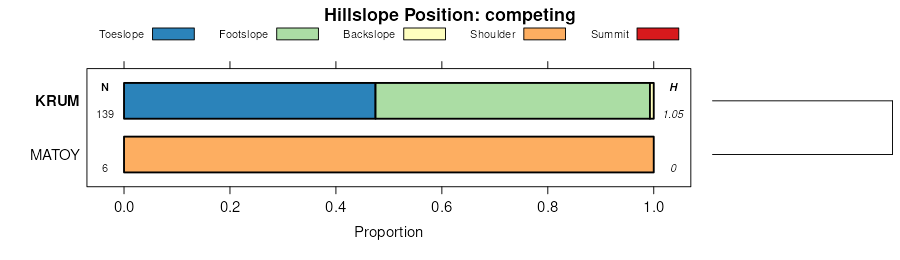
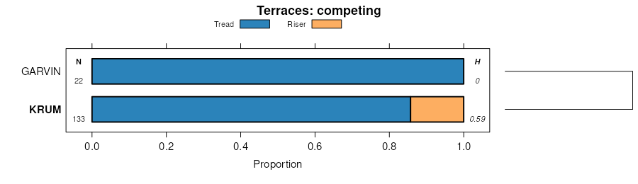
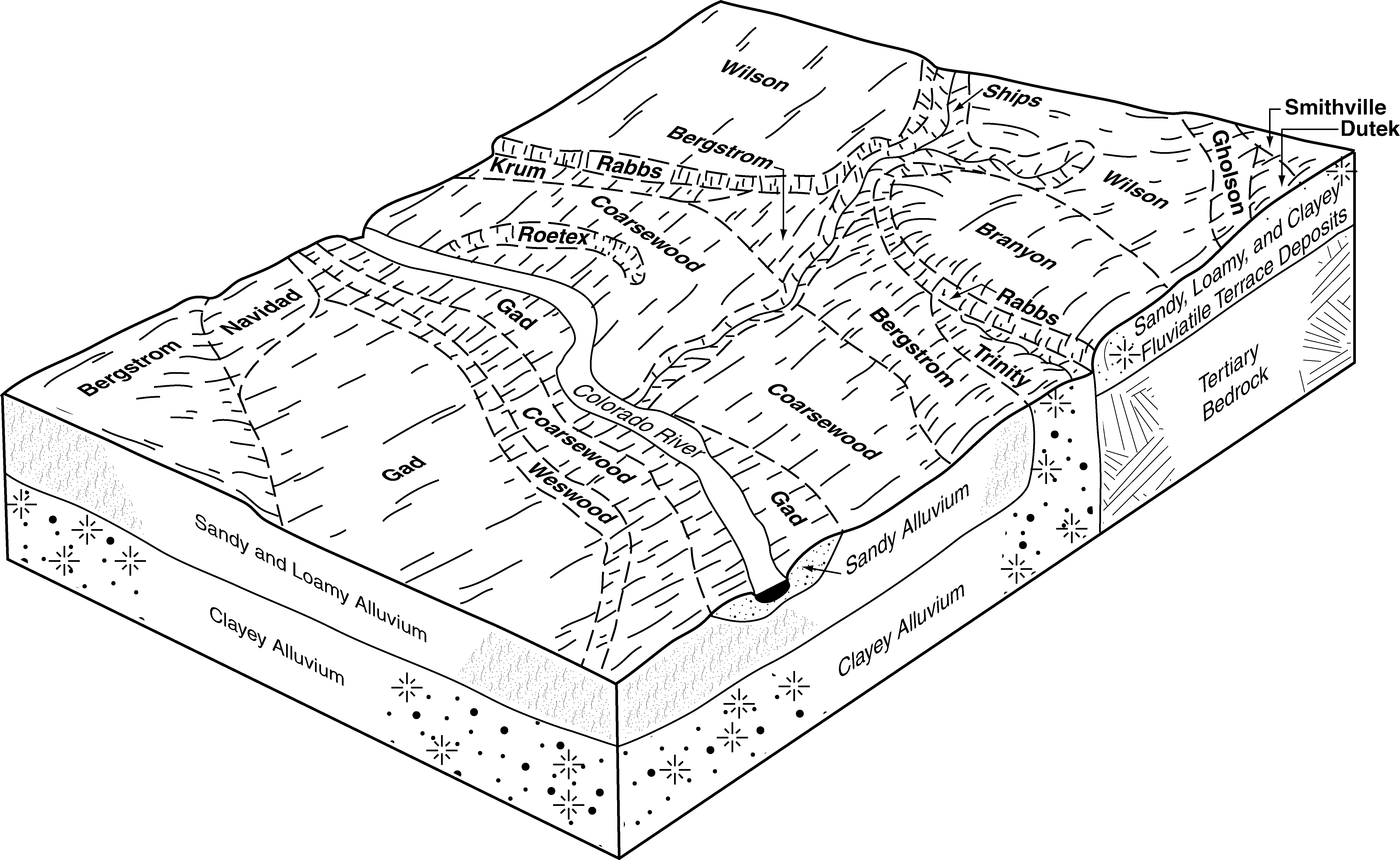
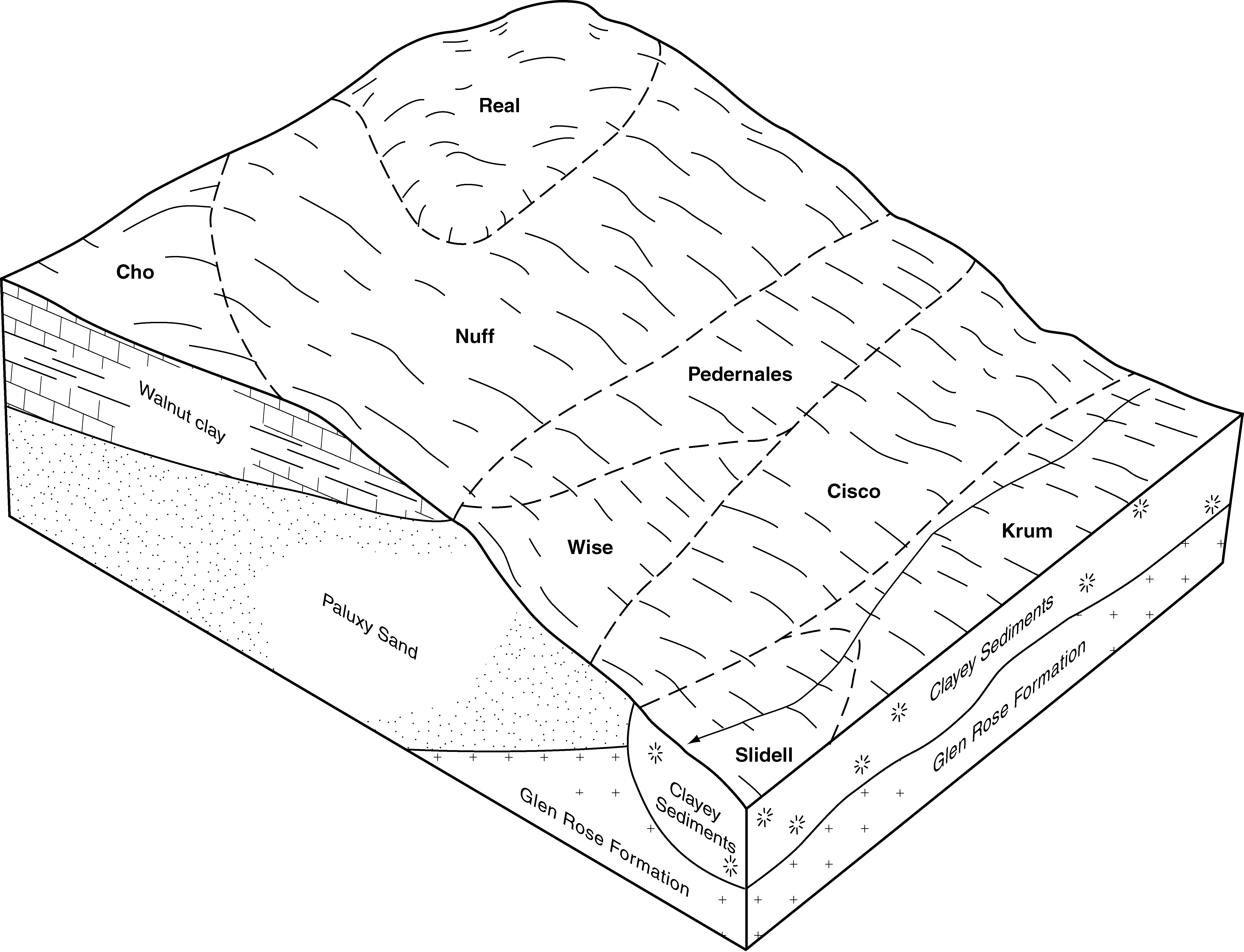
Krum-Pratley association, gently undulatingKRX27907362629d5bqtx01919711:24000
Krum silty clay, 1 to 3 percent slopesKM50993626272t2j8tx01919711:24000
Krum silty clay, 3 to 5 percent slopesKN35693626282t2j9tx01919711:24000
Krum silty clay, 0 to 1 percent slopesKrA2440393303f686tx02119721:24000
Krum silty clay, cool, 1 to 3 percent slopesKrB91363911042wn92tx02719721:24000
Krum silty clay, 0 to 1 percent slopesKrA184739110330my9tx02719721:24000
Lewisville-Krum complex, 1 to 3 percent slopesLekB119231300522s1s2tx02719721:24000
Krum-Branyon complex, 0 to 1 percent slopesKrbA14431300482s1rrtx02719721:24000
Branyon-Krum complex, 1 to 3 percent slopesBrkB9131300372s1rwtx02719721:24000
Krum clay, 1 to 5 percent slopesKr144783904862ylv9tx02920001:24000
Krum clay, 1 to 3 percent slopesKrB217303630012wn93tx03519771:24000
Krum clay, 0 to 1 percent slopesKrA39233630002wn91tx03519771:24000
Krum silty clay, cool, 1 to 3 percent slopesKcB126433643832wn92tx09319741:20000
Krum silty clay, 0 to 1 percent slopesKcA115536438230my9tx09319741:20000
Krum silty clay, cool, 1 to 3 percent slopesKrB204713911602wn92tx09919831:24000
Krum silty clay, rarely floodedKr3361365729d8kqtx14919911:24000
Krum silty clay, 3 to 5 percent slopesKuC11646366199d91wtx17119701:20000
Krum silty clay, 1 to 3 percent slopesKuB3123366198d91vtx17119701:20000
Krum silty clay, cool, 1 to 5 percent slopesKrB305563766642wn94tx19319941:24000
Krum silty clay, 0 to 1 percent slopes54419836776930my9tx21719751:20000
Krum silty clay, cool, 1 to 3 percent slopesKrB48683681802wn92tx25119811:20000
Krum silty clay, 3 to 5 percent slopesKrC123036818130mybtx25119811:20000
Krum silty clay, 3 to 5 percent slopes13204623684532t2j9tx25919791:31680
Krum silty clay, 1 to 3 percent slopes12112703684522t2j8tx25919791:31680
Krum silty clay, 1 to 3 percent slopesKrB139043685302t2j8tx26519831:31680
Krum silty clay, 3 to 5 percent slopesKrC137653685312t2j9tx26519831:31680
Krum-Urban land complex, 1 to 3 percent slopesKuB779368532dch4tx26519831:31680
Krum silty clay, cool, 1 to 5 percent slopesKrB273633688602wn94tx28119901:24000
Krum silty clay, 1 to 3 percent slopesKrB524369798ddsztx29919901:24000
Krum silty clay, cool, 1 to 5 percent slopesKrC26123701052wn94tx30919921:24000
Lewisville-Krum complex, 1 to 3 percent slopesLekB153331300842s1s2tx33119881:24000
Krum clay, 1 to 3 percent slopesKcB116483908872wn93tx36719731:20000
Krum clay, 0 to 1 percent slopesKcA10043908862wn91tx36719731:20000
Branyon-Krum complex, 1 to 3 percent slopesBrkB994231301032s1rwtx49119811:20000
Krum-Branyon complex, 0 to 1 percent slopesKrbA539431301152s1rrtx49119811:20000
Krum silty clay, 1 to 3 percent slopesKrB4147373563djqftx49119811:20000
Krum silty clay, 0 to 1 percent slopesKrA2811373562djqdtx49119811:20000
Lewisville-Krum complex, 1 to 3 percent slopesLekB124431301192s1s2tx49119811:20000
Krum clay, 1 to 3 percent slopes24412543739172t2j5tx60119771:31680
Krum clay, 3 to 5 percent slopes25222933739182t2j6tx60119771:31680
Krum silty clay, cool, 1 to 3 percent slopes39253853910142wn92tx60219751:24000
Krum clay, 1 to 3 percent slopesKrB128263934692t2j5tx60419811:20000
Krum clay, 0 to 1 percent slopesKrA42053907062ynhjtx60419811:20000
Krum clay, 3 to 5 percent slopesKrC14443934702t2j6tx60419811:20000
Krum clay, 1 to 3 percent slopesKrB69263743432wn93tx60919751:20000
Krum clay, 0 to 1 percent slopesKrA8353743422wn91tx60919751:20000

Map of Series Extent

Approximate geographic distribution of the KRUM soil series. To learn more about how this distribution was mapped, or to compare this soil series extent to others, use the Series Extent Explorer (SEE) application. Source: generalization of SSURGO geometry .