| Kranzburg-Brookings silty clay loams, 1 to 6 percent slopes | J90B | 17916 | 991439 | 2wkp4 | mn081 | 2007 | 1:12000 |
Kranzburg-Brookings silty clay loams, 1 to 6 percent slopes | J90B | 1 | 1947682 | 2wkp4 | mn101 | 2008 | 1:12000 |
Kranzburg-Brookings silty clay loams, 1 to 6 percent slopes | J90B | 54508 | 780322 | 2wkp4 | mn117 | 2005 | 1:12000 |
Kranzburg-Lismore silty clay loams, 2 to 6 percent slopes | G782B | 9177 | 2573664 | 2q60q | nd003 | 1988 | 1:20000 |
Lismore-Kranzburg silty clay loams, 0 to 2 percent slopes | G782A | 8360 | 2573663 | 2q60p | nd003 | 1988 | 1:20000 |
Lismore-Kranzburg silty clay loams, 0 to 2 percent slopes | G782A | 962 | 2581215 | 2q60p | nd073 | 1992 | 1:20000 |
Kranzburg-Lismore silty clay loams, 2 to 6 percent slopes | G782B | 217 | 2581216 | 2q60q | nd073 | 1992 | 1:20000 |
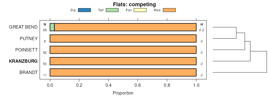
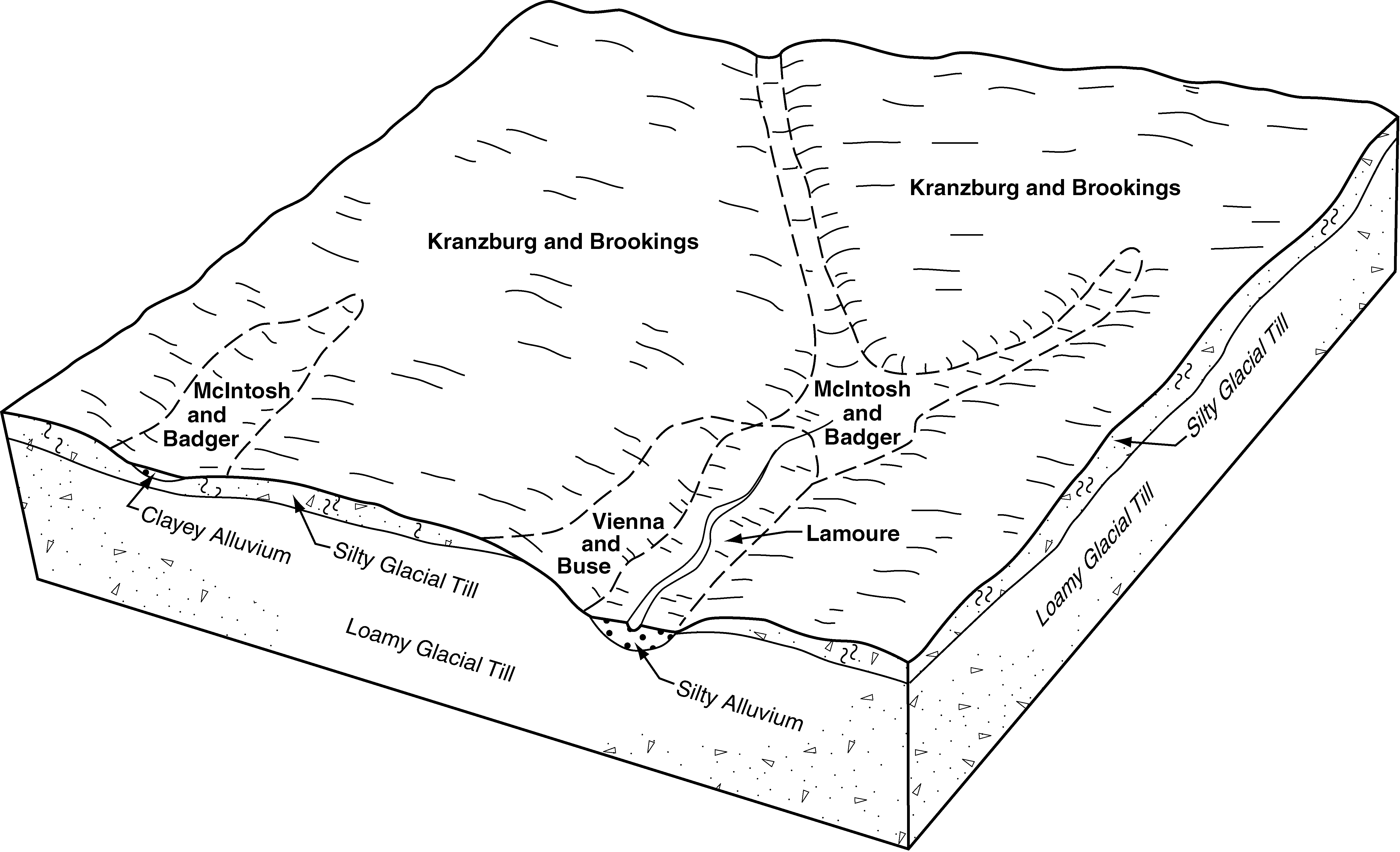
Kranzburg-Brookings silty clay loams, 1 to 6 percent slopes | KrB | 29703 | 418768 | 2wkp4 | sd011 | 1995 | 1:24000 |
Kranzburg-Brookings silty clay loams, 0 to 2 percent slopes | KrA | 20378 | 418767 | 2wkp2 | sd011 | 1995 | 1:24000 |
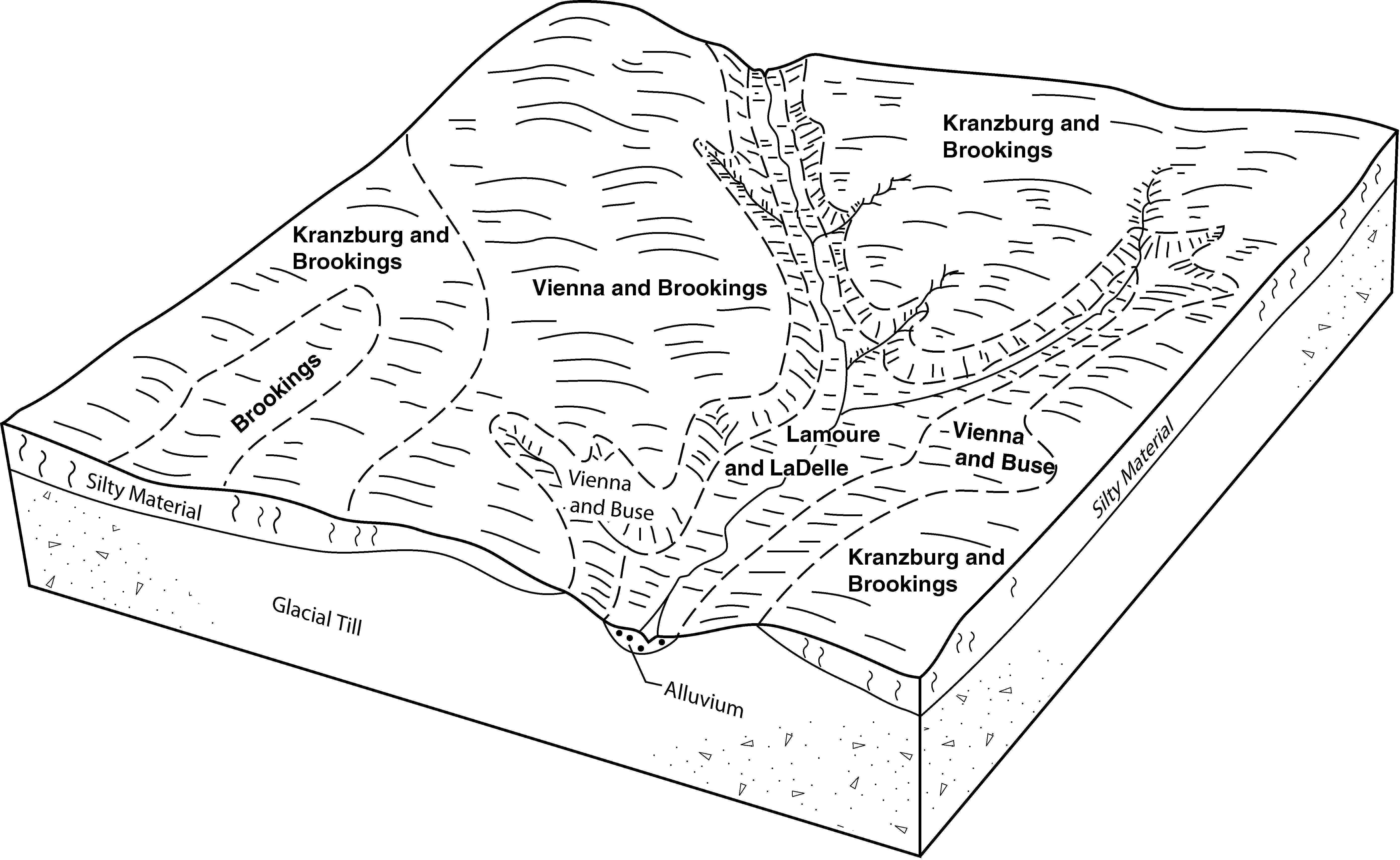
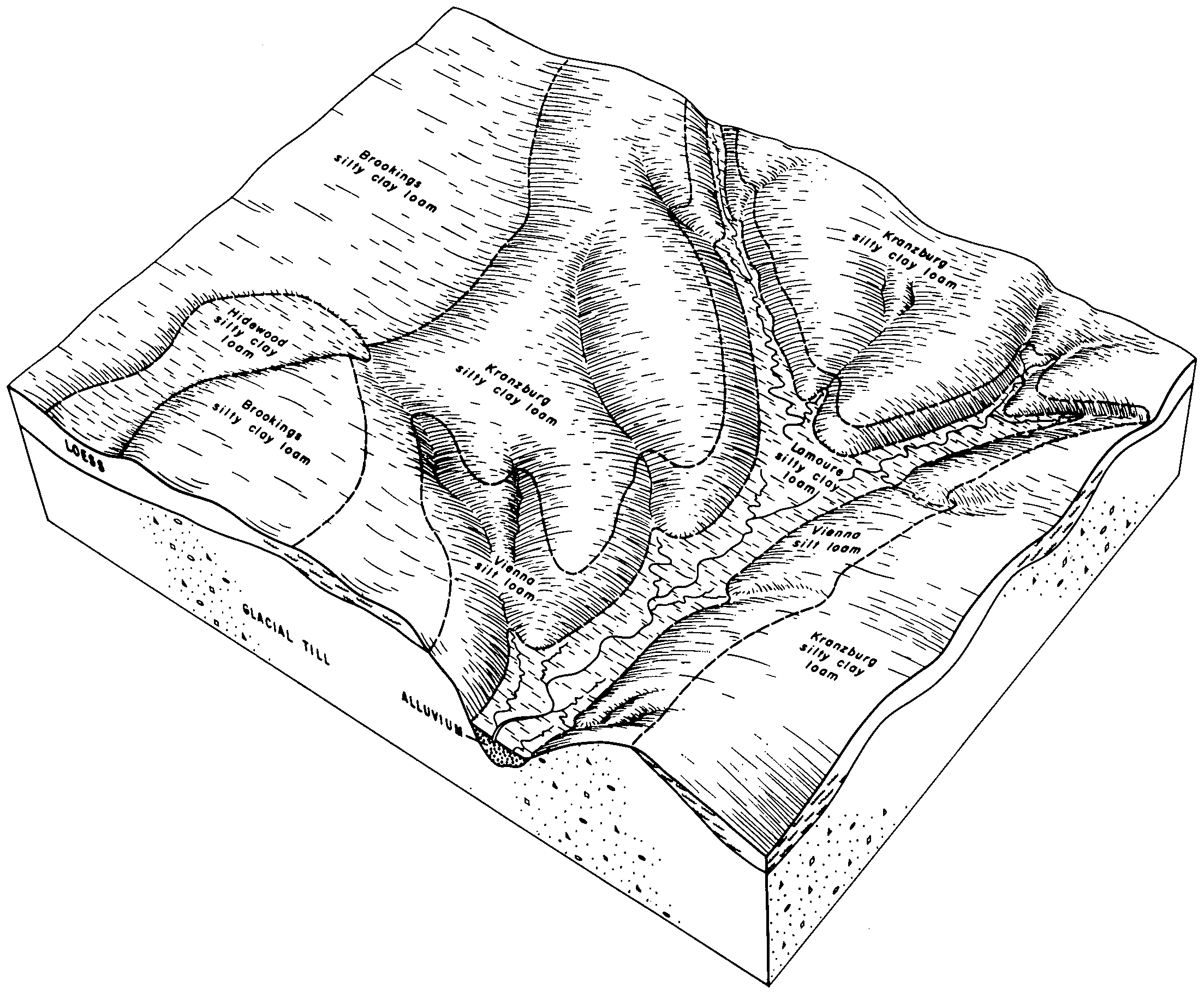
Kranzburg-Brookings silt loams, 0 to 2 percent slopes | G790A | 8681 | 2797820 | 2sd5q | sd013 | 1987 | 1:20000 |
Kranzburg-Brookings-Buse complex, 0 to 6 percent slopes | G792B | 2721 | 2797822 | 2sd5x | sd013 | 1987 | 1:20000 |
Kranzburg-Brookings silt loams, 2 to 6 percent slopes | G790B | 404 | 2797821 | 2sd5r | sd013 | 1987 | 1:20000 |
Barnes-Kranzburg-Buse complex, 6 to 9 percent slopes | G784C | 341 | 2797819 | 2sd5k | sd013 | 1987 | 1:20000 |
Kranzburg-Cresbard silt loams, 0 to 2 percent slopes | G796A | 3 | 2797823 | 2sd62 | sd013 | 1987 | 1:20000 |
Kranzburg-Buse-Waubay complex, 1 to 6 percent slopes | KrB | 19962 | 417748 | g0pr | sd025 | 1992 | 1:20000 |
Kranzburg-Brookings silty clay loams, 0 to 2 percent slopes | J143A | 16463 | 1684436 | 2wkp2 | sd029 | 2006 | 1:12000 |
Kranzburg-Brookings silty clay loams, 1 to 6 percent slopes | J143B | 8233 | 1684438 | 2wkp4 | sd029 | 2006 | 1:12000 |
Kranzburg-Cresbard complex, 0 to 2 percent slopes | J145A | 1228 | 1684449 | 1tjt2 | sd029 | 2006 | 1:12000 |
Kranzburg-Brookings silt loams, 0 to 2 percent slopes | G790A | 32151 | 2798526 | 2sd5q | sd037 | 1992 | 1:20000 |
Kranzburg-Forman complex, 2 to 6 percent slopes | KtB | 17529 | 417094 | 30t1n | sd037 | 1992 | 1:20000 |
Kranzburg-Brookings-Buse complex, 0 to 6 percent slopes | G792B | 11853 | 2798528 | 2sd5x | sd037 | 1992 | 1:20000 |
Kranzburg-Buse-Waubay complex, 1 to 6 percent slopes | KwB | 10302 | 1381307 | 1hcc9 | sd037 | 1992 | 1:20000 |
Kranzburg-Brookings silt loams, 2 to 6 percent slopes | G790B | 3061 | 2798527 | 2sd5r | sd037 | 1992 | 1:20000 |
Kranzburg-Cresbard silt loams, 0 to 2 percent slopes | G796A | 172 | 2798529 | 2sd62 | sd037 | 1992 | 1:20000 |
Kranzburg-Brookings-Buse complex, 1 to 6 percent slopes | KrB | 56 | 417092 | g00l | sd037 | 1992 | 1:20000 |
Kranzburg-Brookings silt loams, 0 to 2 percent slopes | Ks | 37 | 417093 | g00m | sd037 | 1992 | 1:20000 |
Kranzburg-Brookings silty clay loams, 1 to 6 percent slopes | KrB | 34581 | 416867 | 2wkp4 | sd039 | 1992 | 1:20000 |
Kranzburg-Brookings silty clay loams, 0 to 2 percent slopes | KrA | 15185 | 416866 | 2wkp2 | sd039 | 1992 | 1:20000 |
Kranzburg-Brookings silty clay loams, 2 to 9 percent slopes | KrC | 1276 | 416868 | fzsc | sd039 | 1992 | 1:20000 |
Kranzburg-Brookings silty clay loams, 1 to 6 percent slopes | KrB | 6115 | 417283 | 2wkp4 | sd057 | 1992 | 1:20000 |
Kranzburg-Brookings silty clay loams, 0 to 2 percent slopes | KrA | 1941 | 417282 | 2wkp2 | sd057 | 1992 | 1:20000 |
Kranzburg-Brookings silt loams, 0 to 2 percent slopes | G790A | 12841 | 2799374 | 2sd5q | sd091 | 1970 | 1:20000 |
Kranzburg-Brookings silt loams, 2 to 6 percent slopes | G790B | 8494 | 2799375 | 2sd5r | sd091 | 1970 | 1:20000 |
Kranzburg-Cresbard silt loams, 0 to 2 percent slopes | G796A | 2413 | 2799382 | 2sd62 | sd091 | 1970 | 1:20000 |
Kranzburg-Brookings-Buse complex, 0 to 6 percent slopes | G792B | 1525 | 2799380 | 2sd5x | sd091 | 1970 | 1:20000 |
Kranzburg-Vienna silt loams, 6 to 9 percent slopes | G790C | 903 | 2799376 | 2sd5s | sd091 | 1970 | 1:20000 |
Kranzburg-Cresbard silt loams, 2 to 6 percent slopes | G796B | 431 | 2799383 | 2sd63 | sd091 | 1970 | 1:20000 |
Kranzburg silt loam, 0 to 2 percent slopes | KnA | 311 | 416577 | fzgz | sd091 | 1970 | 1:20000 |
Kranzburg silt loam, 2 to 6 percent slopes | KnB | 228 | 416578 | fzh0 | sd091 | 1970 | 1:20000 |
Barnes-Kranzburg-Buse complex, 6 to 9 percent slopes | G784C | 10 | 2799372 | 2sd5k | sd091 | 1970 | 1:20000 |
Kranzburg silt loam, 6 to 9 percent slopes, eroded | KnC2 | 9 | 416579 | fzh1 | sd091 | 1970 | 1:20000 |
Kranzburg-Brookings silty clay loams, 1 to 6 percent slopes | KaB | 18313 | 418340 | 2wkp4 | sd101 | 1985 | 1:20000 |
Kranzburg-Brookings silty clay loams, 0 to 2 percent slopes | KbA | 3020 | 418341 | 2wkp2 | sd101 | 1985 | 1:20000 |
Kranzburg-Cresbard silt loams, 0 to 2 percent slopes | G796A | 14296 | 2800039 | 2sd62 | sd115 | 1997 | 1:24000 |
Kranzburg-Brookings silt loams, 0 to 2 percent slopes | G790A | 6888 | 2800034 | 2sd5q | sd115 | 1997 | 1:24000 |
Kranzburg-Brookings-Buse complex, 0 to 6 percent slopes | G792B | 5557 | 2800036 | 2sd5x | sd115 | 1997 | 1:24000 |
Kranzburg-Zell-Aastad complex, 1 to 6 percent slopes | G793B | 2056 | 2800037 | 2sd5y | sd115 | 1997 | 1:24000 |
Kranzburg-Cresbard-Tonka silt loams, 0 to 2 percent slopes | G797A | 1772 | 2800041 | 2sd64 | sd115 | 1997 | 1:24000 |
Kranzburg-Zell-Aastad complex, 3 to 9 percent slopes | G793C | 368 | 2800064 | 2sl3v | sd115 | 1997 | 1:24000 |
Kranzburg-Brookings silt loams, 2 to 6 percent slopes | G790B | 314 | 2800035 | 2sd5r | sd115 | 1997 | 1:24000 |
Kranzburg-Cresbard silt loams, 2 to 6 percent slopes | G796B | 38 | 2800040 | 2sd63 | sd115 | 1997 | 1:24000 |