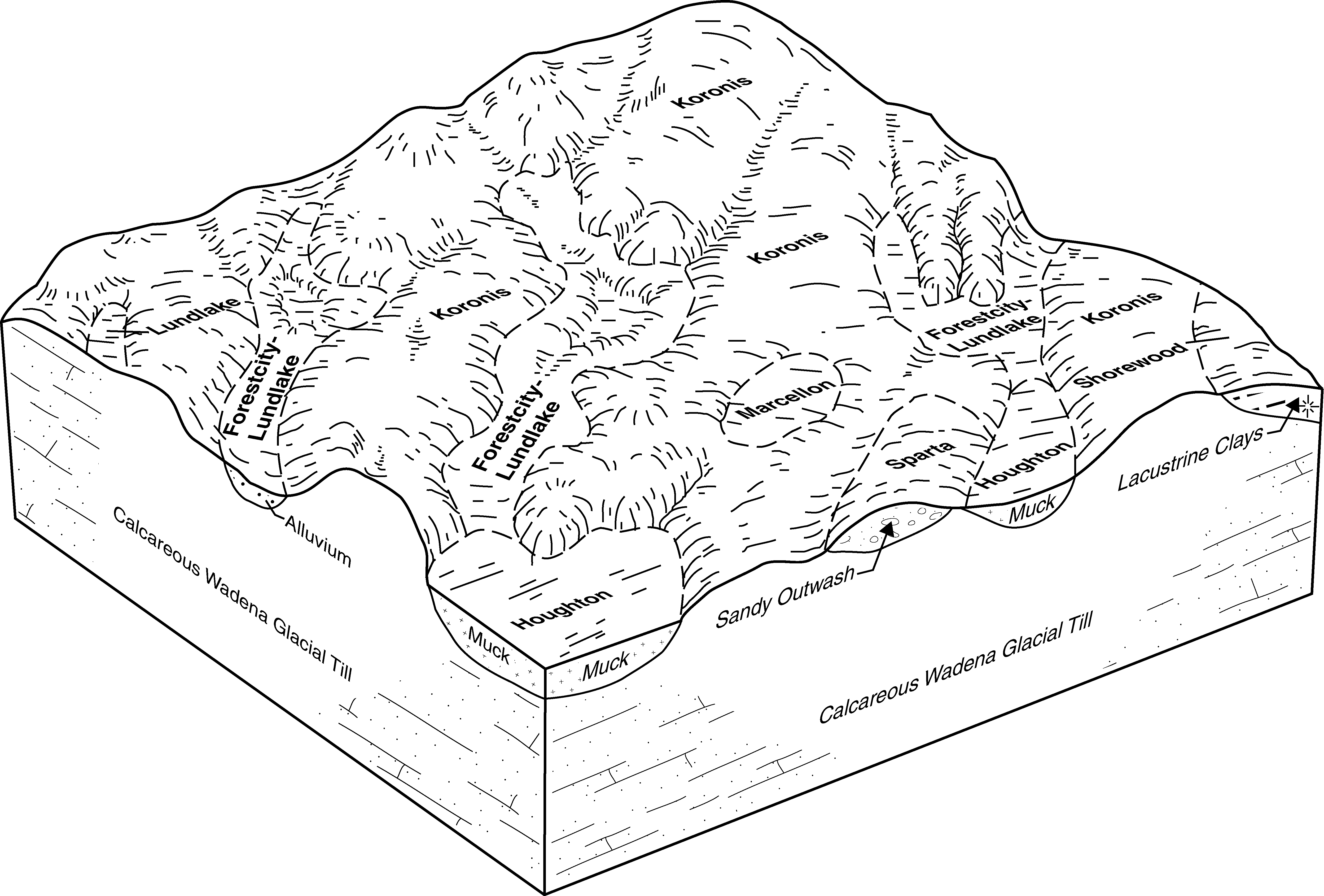
| Koronis-Kingsley complex, 2 to 6 percent slopes | L58B | 1575 | 413391 | fw56 | mn053 | 2001 | 1:12000 |
Koronis-Kingsley complex, 6 to 12 percent slopes, eroded | L58C2 | 1237 | 434666 | gl9h | mn053 | 2001 | 1:12000 |
Koronis-Kingsley-Malardi complex, 18 to 35 percent slopes | L62E | 764 | 399488 | fdpq | mn053 | 2001 | 1:12000 |
Koronis-Kingsley-Malardi complex, 6 to 12 percent slopes, eroded | L62C2 | 714 | 432654 | gj6l | mn053 | 2001 | 1:12000 |
Koronis-Kingsley complex, 12 to 18 percent slopes, eroded | L58D2 | 321 | 434667 | gl9j | mn053 | 2001 | 1:12000 |
Koronis-Kingsley complex, 18 to 25 percent slopes | L58E | 234 | 434668 | gl9k | mn053 | 2001 | 1:12000 |
Koronis-Kingsley-Malardi complex, 2 to 6 percent slopes | L62B | 139 | 399470 | fdp4 | mn053 | 2001 | 1:12000 |
Koronis-Kingsley-Malardi complex, 12 to 18 percent slopes, eroded | L62D2 | 135 | 399484 | fdpl | mn053 | 2001 | 1:12000 |
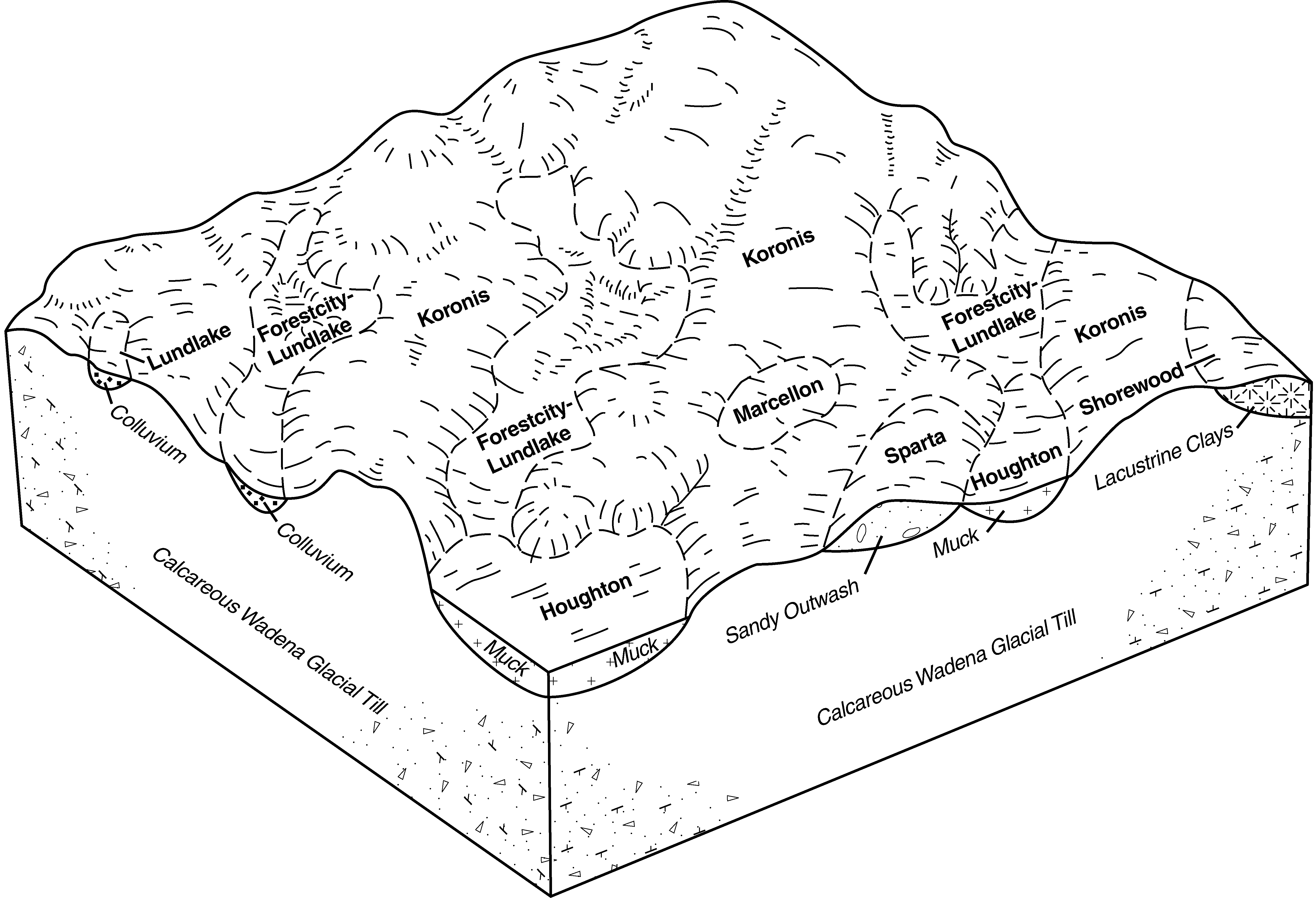
Koronis-Sunburg complex, 6 to 12 percent slopes, moderately eroded | L357C2 | 3246 | 2536646 | 2n801 | mn067 | 1983 | 1:20000 |
Koronis-Sunburg-Hawick complex, 6 to 12 percent slopes, moderately eroded | L355C2 | 2919 | 2536640 | 2n7zw | mn067 | 1983 | 1:20000 |
Koronis-Sunburg complex, 2 to 6 percent slopes | L357B | 2824 | 2536645 | 2n800 | mn067 | 1983 | 1:20000 |
Koronis-Sunburg-Hawick complex, 12 to 18 percent slopes, moderately eroded | L355D2 | 2042 | 2536641 | 2n7zh | mn067 | 1983 | 1:20000 |
Koronis-Hawick complex, 12 to 20 percent slopes | 804D | 1395 | 398708 | fcwk | mn067 | 1983 | 1:20000 |
Koronis-Hawick complex, 6 to 12 percent slopes | 804C | 1332 | 398707 | fcwj | mn067 | 1983 | 1:20000 |
Koronis-Sunburg complex, 12 to 18 percent slopes, moderately eroded | L357D2 | 1297 | 2536647 | 2n7zk | mn067 | 1983 | 1:20000 |
Koronis-Sunburg-Hawick complex, 2 to 6 percent slopes | L355B | 858 | 2536639 | 2n7zv | mn067 | 1983 | 1:20000 |
Koronis-Sunburg-Hawick complex, 18 to 40 percent slopes | L355E | 806 | 2536642 | 2n7zj | mn067 | 1983 | 1:20000 |
Koronis loam, 18 to 40 percent slopes | L307E | 671 | 2510835 | 2pf1t | mn067 | 1983 | 1:20000 |
Koronis-Hawick complex, 20 to 30 percent slopes | 804E | 458 | 398709 | fcwl | mn067 | 1983 | 1:20000 |
Koronis-Hawick complex, 2 to 6 percent slopes | 804B | 333 | 398706 | fcwh | mn067 | 1983 | 1:20000 |
Koronis loam, 2 to 6 percent slopes | L307B | 14 | 2536648 | 2vvg8 | mn067 | 1983 | 1:20000 |
Koronis loam, 6 to 10 percent slopes, moderately eroded | L307C2 | 4 | 2510834 | 2vvgq | mn067 | 1983 | 1:20000 |
Koronis loam, 2 to 6 percent slopes | L307B | 16882 | 2536650 | 2vvg8 | mn093 | 1996 | 1:20000 |
Koronis loam, 6 to 10 percent slopes, moderately eroded | L307C2 | 8680 | 2536651 | 2vvgq | mn093 | 1996 | 1:20000 |
Koronis-Sunburg complex, 12 to 18 percent slopes, moderately eroded | L357D2 | 2657 | 2536682 | 2n7zk | mn093 | 1996 | 1:20000 |
Koronis-Sunburg-Hawick complex, 18 to 40 percent slopes | L355E | 1821 | 2536677 | 2n7zj | mn093 | 1996 | 1:20000 |
Rohrbeck-Koronis complex, 1 to 6 percent slopes | L326B | 1445 | 2536686 | 2n809 | mn093 | 1996 | 1:20000 |
Koronis-Sunburg-Hawick complex, 6 to 12 percent slopes, moderately eroded | L355C2 | 1099 | 2536675 | 2n7zw | mn093 | 1996 | 1:20000 |
Koronis-Sunburg-Hawick complex, 12 to 18 percent slopes, moderately eroded | L355D2 | 680 | 2536676 | 2n7zh | mn093 | 1996 | 1:20000 |
Koronis-Sunburg-Hawick complex, 2 to 6 percent slopes | L355B | 559 | 2536674 | 2n7zv | mn093 | 1996 | 1:20000 |
Koronis-Sunburg-Hawick complex, 12 to 18 percent slopes, eroded | 804D2 | 230 | 436420 | gn42 | mn093 | 1996 | 1:20000 |
Koronis-Sunburg-Hawick complex, 18 to 40 percent slopes | 804E | 125 | 436421 | gn43 | mn093 | 1996 | 1:20000 |
Koronis-Sunburg-Hawick complex, 6 to 12 percent slopes, eroded | 804C2 | 70 | 436419 | gn41 | mn093 | 1996 | 1:20000 |
Koronis-Sunburg-Hawick complex, 2 to 6 percent slopes | 804B | 43 | 436418 | gn40 | mn093 | 1996 | 1:20000 |
Koronis-Sunburg complex, 6 to 12 percent slopes, moderately eroded | L357C2 | 19 | 2536681 | 2n801 | mn093 | 1996 | 1:20000 |
Koronis-Sunburg complex, 2 to 6 percent slopes | L357B | 1 | 2536680 | 2n800 | mn093 | 1996 | 1:20000 |
Koronis loam, 18 to 40 percent slopes | L307E | 1 | 2536652 | 2pf1t | mn093 | 1996 | 1:20000 |
Koronis loam, 2 to 6 percent slopes | L307B | 20093 | 2536690 | 2vvg8 | mn145 | 1980 | 1:15840 |
Koronis loam, 6 to 10 percent slopes, moderately eroded | L307C2 | 8539 | 2536691 | 2vvgq | mn145 | 1980 | 1:15840 |
Koronis-Sunburg complex, 12 to 18 percent slopes, moderately eroded | L357D2 | 1705 | 2536718 | 2n7zk | mn145 | 1980 | 1:15840 |
Koronis loam, 18 to 40 percent slopes | L307E | 1335 | 2536692 | 2pf1t | mn145 | 1980 | 1:15840 |
Koronis-Estherville complex, 12 to 25 percent slopes | 804D | 1099 | 428181 | gck9 | mn145 | 1980 | 1:15840 |
Rohrbeck-Koronis complex, 1 to 6 percent slopes | L326B | 648 | 2536720 | 2n809 | mn145 | 1980 | 1:15840 |
Koronis-Sunburg-Hawick complex, 12 to 18 percent slopes, moderately eroded | L355D2 | 486 | 2536712 | 2n7zh | mn145 | 1980 | 1:15840 |
Koronis-Sunburg-Hawick complex, 18 to 40 percent slopes | L355E | 475 | 2536713 | 2n7zj | mn145 | 1980 | 1:15840 |
Koronis-Sunburg-Hawick complex, 2 to 6 percent slopes | L355B | 301 | 2536710 | 2n7zv | mn145 | 1980 | 1:15840 |
Koronis-Sunburg-Hawick complex, 6 to 12 percent slopes, moderately eroded | L355C2 | 211 | 2536711 | 2n7zw | mn145 | 1980 | 1:15840 |
Koronis-Sunburg complex, 6 to 12 percent slopes, moderately eroded | L357C2 | 5 | 2536717 | 2n801 | mn145 | 1980 | 1:15840 |
Koronis-Sunburg complex, 2 to 6 percent slopes | L357B | 2 | 2536716 | 2n800 | mn145 | 1980 | 1:15840 |
Koronis loam, 6 to 10 percent slopes, moderately eroded | L307C2 | 955 | 2536724 | 2vvgq | mn171 | 1998 | 1:12000 |
Koronis loam, 2 to 6 percent slopes | L307B | 625 | 2536723 | 2vvg8 | mn171 | 1998 | 1:12000 |
Koronis-Sunburg complex, 12 to 18 percent slopes, moderately eroded | L357D2 | 427 | 2527623 | 2n7zk | mn171 | 1998 | 1:12000 |
Koronis loam, 18 to 40 percent slopes | 461E | 412 | 433753 | gkc1 | mn171 | 1998 | 1:12000 |
Koronis-Sunburg-Hawick complex, 18 to 40 percent slopes | L355E | 267 | 2536738 | 2n7zj | mn171 | 1998 | 1:12000 |
Koronis-Sunburg-Hawick complex, 6 to 12 percent slopes, moderately eroded | L355C2 | 251 | 2536736 | 2n7zw | mn171 | 1998 | 1:12000 |
Koronis-Sunburg-Hawick complex, 12 to 18 percent slopes, moderately eroded | L355D2 | 218 | 2536737 | 2n7zh | mn171 | 1998 | 1:12000 |
Koronis-Sunburg-Hawick complex, 2 to 6 percent slopes | L355B | 172 | 2536735 | 2n7zv | mn171 | 1998 | 1:12000 |
Koronis-Sunburg-Hawick complex, 12 to 18 percent slopes, eroded | 804D2 | 29 | 433792 | gkd9 | mn171 | 1998 | 1:12000 |
Koronis-Sunburg-Hawick complex, 2 to 6 percent slopes | 804B | 18 | 433794 | gkdc | mn171 | 1998 | 1:12000 |
Koronis-Sunburg-Hawick complex, 18 to 40 percent slopes | 804E | 11 | 433791 | gkd8 | mn171 | 1998 | 1:12000 |
Koronis-Sunburg-Hawick complex, 6 to 12 percent slopes, eroded | 804C2 | 10 | 433793 | gkdb | mn171 | 1998 | 1:12000 |
Koronis-Sunburg complex, 12 to 18 percent slopes, eroded | 807D2 | 9 | 433788 | gkd5 | mn171 | 1998 | 1:12000 |


