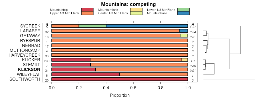
| Klickson cobbly ashy loam, 35 to 65 percent slopes | 21 | 7591 | 2487266 | 2ph6d | id057 | 2013 | 1:24000 |
Klickson-Bluesprin complex, 35 to 65 percent slopes | 22 | 6383 | 2487267 | 2ph6f | id057 | 2013 | 1:24000 |
Klickson ashy silt loam, 25 to 35 percent slopes | 20 | 2478 | 2487265 | 2ph6c | id057 | 2013 | 1:24000 |
Klickson ashy silt loam, 7 to 25 percent slopes | 19 | 901 | 2487264 | 2ph6b | id057 | 2013 | 1:24000 |
Klickson ashy silt loam, 35 to 90 percent slopes | Kn1j | 159 | 2502073 | 2v744 | id057 | 2013 | 1:24000 |
Uptmor-Klickson complex, 20 to 40 percent slopes | Um2 | 117 | 2502081 | 2q2sd | id057 | 2013 | 1:24000 |
Klickson-Agatha association, 25 to 75 percent slopes | Kn2j | 97 | 2502079 | 2nx9 | id057 | 2013 | 1:24000 |
Klickson-Bluesprin association | 68 | 3800 | 2686257 | 5595 | id600 | 1989 | 1:24000 |
Rock outcrop-Klickson complex | 96 | 2848 | 2686268 | 55b5 | id600 | 1989 | 1:24000 |
Klickson-Rock outcrop complex | 66 | 2786 | 2686255 | 5593 | id600 | 1989 | 1:24000 |
Bluesprin-Klickson association | 5 | 1608 | 2686232 | 558j | id600 | 1989 | 1:24000 |
Klickson-Suloaf complex | 67 | 1467 | 2686256 | 5594 | id600 | 1989 | 1:24000 |
Keuterville-Klickson association | 65 | 546 | 2686254 | 5592 | id600 | 1989 | 1:24000 |
Klickson-Suloaf complex | 67 | 250 | 2686336 | 5594 | id609 | 1989 | 1:24000 |
Bluesprin-Klickson association | 5 | 117 | 2686315 | 558j | id609 | 1989 | 1:24000 |
Klickson-Wapshilla association | 69 | 107 | 2686338 | 5596 | id609 | 1989 | 1:24000 |
Klickson-Bluesprin association | 68 | 50 | 2686337 | 5595 | id609 | 1989 | 1:24000 |
Klickson-Rock outcrop complex | 66 | 15 | 2686335 | 5593 | id609 | 1989 | 1:24000 |
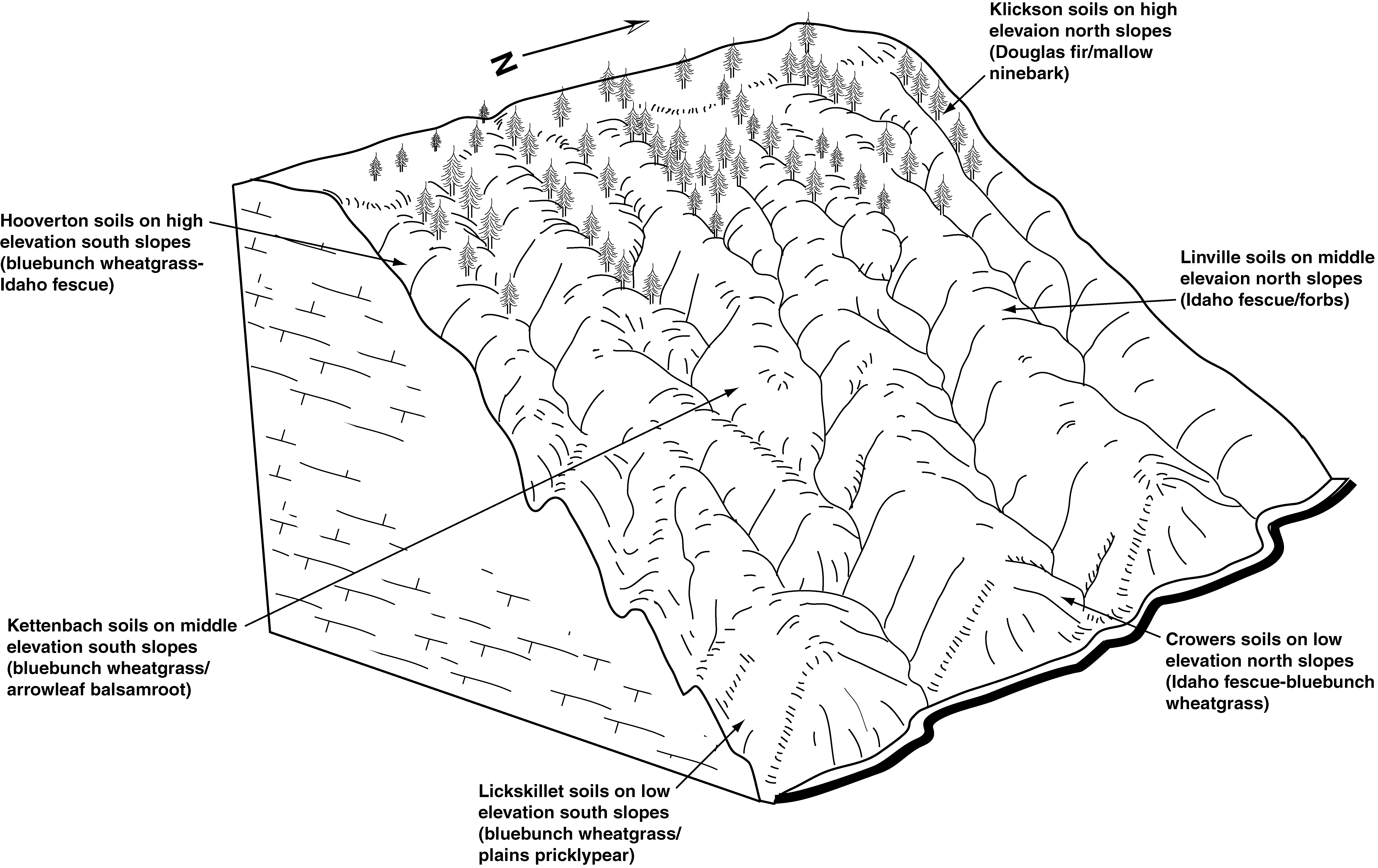
Klickson-Hooverton association, 35 to 90 percent slopes | 66 | 57637 | 79680 | 2nxb | id611 | 1994 | 1:24000 |
Klickson ashy silt loam, 35 to 90 percent slopes | 64 | 16897 | 79678 | 2v744 | id611 | 1994 | 1:24000 |
Klickson-Rock outcrop complex, 45 to 90 percent slopes | 67 | 5151 | 79681 | 2nxc | id611 | 1994 | 1:24000 |
Klickson-Uptmor complex, 10 to 40 percent slopes | 68 | 4810 | 79682 | 2y6ts | id611 | 1994 | 1:24000 |
Klickson-Agatha association, 25 to 75 percent slopes | 65 | 4386 | 79679 | 2nx9 | id611 | 1994 | 1:24000 |
Klickson ashy silt loam, 8 to 35 percent slopes | 63 | 1657 | 79677 | 2nx7 | id611 | 1994 | 1:24000 |
Klickson-Bluesprin complex, 35 to 65 percent slopes | 22j | 120 | 2743101 | 2ph6f | id611 | 1994 | 1:24000 |
Klickson-Rock outcrop-Kettenbach complex, 35 to 85 percent slopes | 67j | 35 | 679210 | qss0 | id611 | 1994 | 1:24000 |
Uptmor-Klickson complex, 20 to 40 percent slopes | Um2 | 33 | 2743082 | 2q2sd | id611 | 1994 | 1:24000 |
Klickson ashy silt loam, 35 to 90 percent slopes | 145 | 5904 | 777310 | 2v744 | id612 | 2003 | 1:24000 |
Klickson-Agatha association, 25 to 75 percent slopes | 146 | 4607 | 777311 | 2nx9 | id612 | 2003 | 1:24000 |
Klickson-Rock outcrop-Kettenbach complex, 35 to 85 percent slopes | 148 | 4296 | 777314 | qss0 | id612 | 2003 | 1:24000 |
Klickson ashy silt loam, 8 to 35 percent slopes | 144 | 3966 | 777313 | 2nx7 | id612 | 2003 | 1:24000 |
Klickson-Kettenbach association, 35 to 90 percent slopes | 147 | 1674 | 777312 | v2vl | id612 | 2003 | 1:24000 |
Bluesprin-Klickson association | 5 | 28325 | 154024 | 558j | id617 | 1976 | 1:24000 |
Klickson-Bluesprin complex, 30 to 75 percent slopes | 68 | 27319 | 154044 | 2y6tc | id617 | 1976 | 1:24000 |
Klickson-Suloaf complex | 67 | 20630 | 154043 | 5594 | id617 | 1976 | 1:24000 |
Klickson-Rock outcrop complex | 66 | 11082 | 154042 | 5593 | id617 | 1976 | 1:24000 |
Klickson-Wapshilla association | 69 | 3599 | 154045 | 5596 | id617 | 1976 | 1:24000 |
Rock outcrop-Klickson complex | 96 | 2721 | 154075 | 55b5 | id617 | 1976 | 1:24000 |
Keuterville-Klickson association | 65 | 762 | 154041 | 5592 | id617 | 1976 | 1:24000 |
Klickson-Uptmor complex, 10 to 40 percent slopes | 2y6ts | 450 | 3098884 | 2y6ts | id617 | 1976 | 1:24000 |
Klickson-Bluesprin complex, 30 to 75 percent slopes | 2y6tc | 6259 | 3098900 | 2y6tc | id618 | 1965 | 1:24000 |
Klickson ashy silt loam, 8 to 35 percent slopes | 2nx7 | 736 | 3098895 | 2nx7 | id618 | 1965 | 1:24000 |
Klickson ashy silt loam, 35 to 90 percent slopes | 2v744 | 705 | 3098896 | 2v744 | id618 | 1965 | 1:24000 |
Klickson-Rock outcrop complex, 40 to 90 percent slopes | 109 | 1242 | 81106 | 2qdb | id656 | 1992 | 1:24000 |
Klickson silt loam, 30 to 60 percent slopes | 108 | 895 | 81105 | 2qd9 | id656 | 1992 | 1:24000 |
Klickson-Wapshilla association | 617069 | 217 | 3417660 | 5596 | id700 | | 1:24000 |
Rock outcrop-Klickson complex | 617096 | 216 | 3417663 | 55b5 | id700 | | 1:24000 |
Klickson-Rock outcrop complex, 40 to 90 percent slopes | 656109 | 165 | 3332373 | 2qdb | id700 | | 1:24000 |
Klickson-Tolo-Larabee complex, 30 to 60 percent slopes | 5745CO | 97 | 3472479 | 1r1h8 | or021 | 1978 | 1:24000 |
Klickson-Bolobin-Fivebit complex, 15 to 30 percent slopes | 4977BE | 68 | 3472477 | 20bmf | or021 | 1978 | 1:24000 |
Larabee-Klickson-Anatone complex, 30 to 60 percent slopes | 4941CD | 10523 | 3120491 | 1r18s | or607 | 2018 | 1:24000 |
Larabee-Klickson complex, 30 to 60 percent slopes | 4159CO | 7261 | 3120304 | 1qxwg | or607 | 2018 | 1:24000 |
Klickson-Bolobin-Anatone complex, 30 to 60 percent slopes | 5728CO | 6060 | 3120534 | 1r1gp | or607 | 2018 | 1:24000 |
Larabee-Klickson-Rock outcrop complex, 60 to 90 percent slopes | 4159DO | 5538 | 3120477 | 1r0yc | or607 | 2018 | 1:24000 |
Klickson-Tolo-Larabee complex, 30 to 60 percent slopes | 5745CO | 4563 | 3120537 | 1r1h8 | or607 | 2018 | 1:24000 |
Gwin-Klickson-Kettenbach complex, 60 to 90 percent slopes | 6121DO | 2635 | 3120795 | 2mtd0 | or607 | 2018 | 1:24000 |
Klickson-Bolobin-Fivebit complex, 15 to 30 percent slopes | 4977BE | 1856 | 3120789 | 20bmf | or607 | 2018 | 1:24000 |
Klicker-Bocker-Klickson complex, 15 to 30 percent slopes | 5896BO | 1673 | 3120741 | 1t162 | or607 | 2018 | 1:24000 |
Klickson-Tolo-Larabee complex, 15 to 30 percent slopes | 5745BO | 1432 | 3120536 | 1r1h7 | or607 | 2018 | 1:24000 |
Larabee-Klickson complex, 15 to 30 percent slopes | 6034BO | 1380 | 3120754 | 1t1lz | or607 | 2018 | 1:24000 |
Bennettcreek-Limberjim-Klickson complex, 0 to 15 percent slopes | 5941AO | 1333 | 3120575 | 1r2k7 | or607 | 2018 | 1:24000 |
Klickson-Larabee complex, 30 to 60 percent slopes | 5874CO | 1173 | 3120308 | 1qxwt | or607 | 2018 | 1:24000 |
Melhorn-Larabee-Klickson complex, depositional, 30 to 60 percent slopes | 4947CD | 1112 | 3120495 | 1r190 | or607 | 2018 | 1:24000 |
Larabee-Klickson-Fivebeaver complex, 30 to 60 percent slopes | 5944CO | 1034 | 3120578 | 1r2kd | or607 | 2018 | 1:24000 |
Nibolob-Klickson-Larabee complex, 30 to 60 percent slopes | 5987CO | 992 | 3120595 | 1r2nx | or607 | 2018 | 1:24000 |
Klickson-Klicker-Anatone complex, 60 to 90 percent slopes | 4942DO | 617 | 3120492 | 1r18t | or607 | 2018 | 1:24000 |
Klickson-Meaufun-Rock outcrop complex, landslide, 0 to 30 percent slopes | 6124NL | 272 | 3120801 | 2ptgs | or607 | 2018 | 1:24000 |
Klickson-Anatone-Larabee complex, 60 to 90 percent north slopes | 6067DN | 255 | 3120204 | nj89 | or607 | 2018 | 1:24000 |
Fivebeaver-Klickson-Bocker complex, 30 to 60 percent slopes | 4978CO | 217 | 3120507 | 1r19l | or607 | 2018 | 1:24000 |
Larabee-Klickson-Volstead complex, 15 to 30 percent north slopes | 6070BN | 194 | 3120205 | nj8s | or607 | 2018 | 1:24000 |
Larabee-Tolo-Klickson complex, 0 to 15 percent slopes | 5013AO | 75 | 3120520 | 1r1bb | or607 | 2018 | 1:24000 |
Klickson-Larabee complex, 15 to 30 percent slopes | 5874BO | 69 | 3120285 | 1qq04 | or607 | 2018 | 1:24000 |
Harl-Klickson complex, 30 to 60 percent slopes | 5792CO | 60 | 3120283 | 1qpy2 | or607 | 2018 | 1:24000 |
Larabee-Klickson-Rock outcrop complex, 0 to 15 percent slopes | 4159AO | 30 | 3120476 | 1r0yb | or607 | 2018 | 1:24000 |
Klickson-Meaufun-Rock Outcrop complex, landslide, 30 to 70 percent slopes | 6124CL | 28 | 3120803 | 2r5ln | or607 | 2018 | 1:24000 |
Klickson-Tolo complex, mass failure, 30 to 60 percent slopes | 5018CM | 22 | 3120524 | 1r1bj | or607 | 2018 | 1:24000 |
Klickson-Larabee complex, 60 to 90 percent slopes | 5874DO | 22 | 3120739 | 1sj3n | or607 | 2018 | 1:24000 |
Klickson-Anatone-Larabee complex, 30 to 60 percent north slopes | 6067CN | 15 | 3120203 | nj85 | or607 | 2018 | 1:24000 |
Klickson-Larabee complex, mass failure, 30 to 60 percent slopes | 4951CM | 4 | 3120497 | 1r192 | or607 | 2018 | 1:24000 |
Larabee-Klickson complex, 30 to 60 percent slopes | 4159CO | 11056 | 3122145 | 1qxwg | or626 | 2018 | 1:24000 |
Larabee-Klickson complex, 15 to 30 percent slopes | 6034BO | 2955 | 3122492 | 1t1lz | or626 | 2018 | 1:24000 |
Larabee-Klickson-Fivebeaver complex, 30 to 60 percent slopes | 5944CO | 1900 | 3122366 | 1r2kd | or626 | 2018 | 1:24000 |
Fivebeaver-Klickson-Bocker complex, 30 to 60 percent slopes | 4978CO | 1735 | 3122321 | 1r19l | or626 | 2018 | 1:24000 |
Klickson-Tolo-Larabee complex, 30 to 60 percent slopes | 5745CO | 1265 | 3122351 | 1r1h8 | or626 | 2018 | 1:24000 |
Kamela-Fivebeaver-Klickson complex, 0 to 15 percent slopes | 5713AO | 1249 | 3385434 | 1r1by | or626 | 2018 | 1:24000 |
Klickson-Larabee complex, 30 to 60 percent slopes | 5874CO | 1243 | 3122150 | 1qxwt | or626 | 2018 | 1:24000 |
Larabee-Klickson-Rock outcrop complex, 60 to 90 percent slopes | 4159DO | 1219 | 3122284 | 1r0yc | or626 | 2018 | 1:24000 |
Kamela-Fivebeaver-Klickson complex, 15 to 30 percent slopes | 5713BO | 526 | 3385435 | 1r1gc | or626 | 2018 | 1:24000 |
Klickson-Meaufun-Rock Outcrop complex, landslide, 30 to 70 percent slopes | 6124CL | 486 | 3385446 | 2r5ln | or626 | 2018 | 1:24000 |
Klickson-Meaufun-Rock outcrop complex, landslide, 0 to 30 percent slopes | 6124NL | 433 | 3385447 | 2ptgs | or626 | 2018 | 1:24000 |
Larabee-Klickson-Anatone complex, 30 to 60 percent slopes | 4941CD | 331 | 3122304 | 1r18s | or626 | 2018 | 1:24000 |
Melhorn-Larabee-Klickson complex, depositional, 30 to 60 percent slopes | 4947CD | 145 | 3122308 | 1r190 | or626 | 2018 | 1:24000 |
Kahler-Klickson-Tolo complex, 1 to 8 percent slopes | 4228AW | 77 | 3385285 | 2ksvc | or626 | 2018 | 1:24000 |
Larabee-Tolo-Klickson complex, 0 to 15 percent slopes | 5013AO | 58 | 3122336 | 1r1bb | or626 | 2018 | 1:24000 |
Klickson-Larabee complex, mass failure, 30 to 60 percent slopes | 4951CM | 51 | 3122310 | 1r192 | or626 | 2018 | 1:24000 |
Klickson-Tolo complex, mass failure, 30 to 60 percent slopes | 5018CM | 37 | 3122341 | 1r1bj | or626 | 2018 | 1:24000 |
Klickson-Bolobin-Fivebit complex, 15 to 30 percent slopes | 4977BE | 32 | 3122517 | 20bmf | or626 | 2018 | 1:24000 |
Larabee-Klickson-Rock outcrop complex, 0 to 15 percent slopes | 4159AO | 24 | 3122283 | 1r0yb | or626 | 2018 | 1:24000 |
Klickson-Bolobin-Anatone complex, 30 to 60 percent slopes | 5728CO | 13 | 3122348 | 1r1gp | or626 | 2018 | 1:24000 |
Kahler-Klickson-Tolo complex, 1 to 8 percent slopes | 40B | 1213 | 3429494 | 2ksvc | or627 | | 1:24000 |
Crackercreek-Klickson-Fivebeaver association, landslide. 5 to 60 percent slopes | 404F | 746 | 3431956 | 2ksvd | or627 | | 1:24000 |
Larabee-Klickson complex, 30 to 60 percent slopes | 4159CO | 606 | 3429789 | 1qxwg | or627 | | 1:24000 |
Larabee-Klickson-Fivebeaver complex, 30 to 60 percent slopes | 5944CO | 453 | 3426033 | 1r2kd | or627 | | 1:24000 |
Larabee-Klickson-Anatone complex, 30 to 60 percent slopes | 4941CD | 450 | 3429810 | 1r18s | or627 | | 1:24000 |
Klickson-Larabee complex, 30 to 60 percent slopes | 5874CO | 201 | 3431893 | 1qxwt | or627 | | 1:24000 |
Melhorn-Larabee-Klickson complex, 30 to 60 percent slopes, depositional | 4947CD | 157 | 3429811 | 2ktzl | or627 | | 1:24000 |
Larabee-Klickson complex, 15 to 30 percent slopes | 6034BO | 127 | 3425221 | 1t1lz | or627 | | 1:24000 |
Fivebit, moist-Klickson-Bocker complex, 30 to 60 percent slopes | 4978CO | 94 | 3429812 | 2ktzq | or627 | | 1:24000 |
Klickson-Tolo-Larabee complex, 30 to 60 percent slopes | 5745CO | 63 | 3426035 | 1r1h8 | or627 | | 1:24000 |
Klickson-Bolobin-Anatone complex, 30 to 60 percent slopes | 5728CO | 39 | 3425222 | 1r1gp | or627 | | 1:24000 |
Larabee-Klickson-Rock outcrop complex, 60 to 90 percent slopes | 4159DO | 7 | 3425228 | 1r0yc | or627 | | 1:24000 |
Klickson-Larabee complex, 60 to 90 percent slopes | 5874DO | 6739 | 2437393 | 1sj3n | or631 | 2018 | 1:24000 |
Klickson-Getaway-Terlough complex, 0 to 60 percent slopes | 5829RW | 5211 | 2437342 | 1qxwn | or631 | 2018 | 1:24000 |
Larabee-Klickson complex, 30 to 60 percent slopes | 4159CO | 4110 | 2437208 | 1qxwg | or631 | 2018 | 1:24000 |
Klickson-Larabee complex, 30 to 60 percent slopes | 5874CO | 4105 | 2437392 | 1qxwt | or631 | 2018 | 1:24000 |
Harl-Klickson complex, 30 to 60 percent slopes | 5792CO | 3784 | 2437321 | 1qpy2 | or631 | 2018 | 1:24000 |
Klickson-Kamela-Getaway complex, 30 to 60 percent slopes | 6115CO | 3013 | 2486864 | 1qpxq | or631 | 2018 | 1:24000 |
Klickson-Larabee-Volstead complex, 30 to 60 percent north slopes | 5871CO | 2171 | 2437387 | nj8h | or631 | 2018 | 1:24000 |
Klickson-Larabee-Bunchpoint complex, 15 to 30 percent slopes | 4160BO | 2084 | 2437210 | 1r0yd | or631 | 2018 | 1:24000 |
Klickson-Getaway-Anatone complex, 30 to 60 percent slopes | 5781CO | 1655 | 2437310 | 1r1pd | or631 | 2018 | 1:24000 |
Klickson-Crackercreek-Kamela complex, 30 to 60 percent slopes | 5712CO | 826 | 2437249 | 1q71c | or631 | 2018 | 1:24000 |
Kamela-Fivebeaver-Klickson complex, 15 to 30 percent slopes | 5713BO | 718 | 2437251 | 1r1gc | or631 | 2018 | 1:24000 |
Klickson-Larabee complex, 15 to 30 percent slopes | 5874BO | 685 | 2437391 | 1qq04 | or631 | 2018 | 1:24000 |
Larabee-Klickson-Anatone complex, 30 to 60 percent slopes | 4941CD | 671 | 2437229 | 1r18s | or631 | 2018 | 1:24000 |
Larabee-Dunstan-Klickson complex, 60 to 90 percent slopes | 4157DO | 641 | 2437205 | 1shsb | or631 | 2018 | 1:24000 |
Klickson-Anatone-Larabee complex, 60 to 90 percent north slopes | 6067DN | 546 | 2437452 | nj89 | or631 | 2018 | 1:24000 |
Larabee-Klickson-Rock outcrop complex, 0 to 15 percent slopes | 4159AO | 478 | 2437207 | 1r0yb | or631 | 2018 | 1:24000 |
Klickson-Olot-Fivebeaver complex, 15 to 30 percent slopes | 5711BO | 415 | 2437248 | 1r1bx | or631 | 2018 | 1:24000 |
Kamela-Fivebeaver-Klickson complex, 0 to 15 percent slopes | 5713AO | 379 | 2437250 | 1r1by | or631 | 2018 | 1:24000 |
Larabee-Klickson-Rock outcrop complex, 60 to 90 percent slopes | 4159DO | 333 | 2437209 | 1r0yc | or631 | 2018 | 1:24000 |
Klickson-Mugwump complex, 15 to 30 percent slopes | 5736BO | 328 | 2437270 | 1shxk | or631 | 2018 | 1:24000 |
Klickson-Anatone-Larabee complex, 30 to 60 percent north slopes | 6067CN | 223 | 2437451 | nj85 | or631 | 2018 | 1:24000 |
Larabee-Klickson-Volstead complex, 15 to 30 percent north slopes | 6070BN | 135 | 2437453 | nj8s | or631 | 2018 | 1:24000 |
Larabee-Getaway-Klickson complex, 30 to 60 percent north slopes | 6069CN | 17 | 2486863 | nj8r | or631 | 2018 | 1:24000 |
Larabee-Klickson complex, 15 to 30 percent slopes | 6034BO | 16 | 2437443 | 1t1lz | or631 | 2018 | 1:24000 |
Gwin-Klickson-Kettenbach complex, 60 to 90 percent slopes | 6121DO | 3 | 2437468 | 2mtd0 | or631 | 2018 | 1:24000 |
Klickson-Larabee complex, 30 to 60 percent slopes | 9031 | 281 | 2722276 | 2sf32 | or645 | | 1:24000 |
Klickson-Bolobin-Fivebit complex, 15 to 30 percent slopes | 4977BE | 360 | 3121538 | 20bmf | or648 | 1977 | 1:24000 |
Klickson-Tolo-Larabee complex, 30 to 60 percent slopes | 5745CO | 332 | 3121527 | 1r1h8 | or648 | 1977 | 1:24000 |
Klickson-Tolo-Larabee complex, 15 to 30 percent slopes | 5745BO | 319 | 3121526 | 1r1h7 | or648 | 1977 | 1:24000 |
Larabee-Klickson-Anatone complex, 30 to 60 percent slopes | 4941CD | 409 | 3121460 | 1r18s | or667 | 1984 | 1:20000 |
Bennettcreek-Limberjim-Klickson complex, 0 to 15 percent slopes | 5941AO | 408 | 3121477 | 1r2k7 | or667 | 1984 | 1:20000 |
Larabee-Klickson-Fivebeaver complex, 30 to 60 percent slopes | 5944CO | 259 | 3121479 | 1r2kd | or667 | 1984 | 1:20000 |
Klickson-Klicker-Anatone complex, 60 to 90 percent slopes | 4942DO | 175 | 3121461 | 1r18t | or667 | 1984 | 1:20000 |
Larabee-Klickson complex, 30 to 60 percent slopes | 4159CO | 113 | 3121450 | 1qxwg | or667 | 1984 | 1:20000 |
Larabee-Klickson-Rock outcrop complex, 60 to 90 percent slopes | 4159DO | 82 | 3121459 | 1r0yc | or667 | 1984 | 1:20000 |
Klicker-Bocker-Klickson complex, 15 to 30 percent slopes | 5896BO | 65 | 3121483 | 1t162 | or667 | 1984 | 1:20000 |
Klickson-Anatone-Larabee complex, 60 to 90 percent north slopes | 169 | 3382 | 84542 | 2tz5 | or670 | 1999 | 1:24000 |
Klickson-Anatone-Larabee complex, 30 to 60 percent north slopes | 168 | 2288 | 84541 | 2tz4 | or670 | 1999 | 1:24000 |
Larabee-Getaway-Klickson complex, 30 to 60 percent north slopes | 174 | 2021 | 84548 | 2tzc | or670 | 1999 | 1:24000 |
Larabee-Klickson-Volstead complex, 30 to 60 percent north slopes | 176 | 615 | 84549 | 2tzd | or670 | 1999 | 1:24000 |
Klickson-Larabee-Volstead complex, 30 to 60 percent north slopes | 171 | 501 | 84545 | 2tz8 | or670 | 1999 | 1:24000 |
Gwin-Klickson-Kettenbach association, 60 to 90 percent slopes | 96 | 459 | 84825 | 2v89 | or670 | 1999 | 1:24000 |
Klickson-Meaufun-Rock outcrop complex, landslide, 0 to 30 percent slopes | 6124NL | 426 | 3122542 | 2ptgs | or670 | 1999 | 1:24000 |
Klickson-Meaufun-Rock Outcrop complex, landslide, 30 to 70 percent slopes | 6124CL | 323 | 3122543 | 2r5ln | or670 | 1999 | 1:24000 |
Larabee-Klickson-Volstead complex, 15 to 30 percent north slopes | 175 | 168 | 84465 | 2twp | or670 | 1999 | 1:24000 |
Klickson-Larabee complex, 15 to 30 percent north slopes | 170 | 100 | 84543 | 2tz6 | or670 | 1999 | 1:24000 |
Larabee-Klickson-Rock outcrop complex, 60 to 90 percent slopes | 4159DO | 1541 | 3424975 | 1r0yc | or677 | | 1:24000 |
Klickson-Tolo-Larabee complex, 30 to 60 percent slopes | 5745CO | 767 | 3424982 | 1r1h8 | or677 | | 1:24000 |
Klickson-Bolobin-Fivebit complex, 15 to 30 percent slopes | 4977BE | 464 | 3424937 | 20bmf | or677 | | 1:24000 |
Klickson-Bolobin-Anatone complex, 30 to 60 percent slopes | 5728CO | 433 | 3424969 | 1r1gp | or677 | | 1:24000 |
Larabee-Klickson-Fivebeaver complex, 30 to 60 percent slopes | 5944CO | 418 | 3424980 | 1r2kd | or677 | | 1:24000 |
Larabee-Klickson complex, 15 to 30 percent slopes | 6034BO | 61 | 3424968 | 1t1lz | or677 | | 1:24000 |
Klickson-Speigle complex, mass wasted, 15 to 30 percent slopes | 2043 | 5024 | 620935 | nv45 | wa063 | 2012 | 1:24000 |
Klickson-Speigle-Rock outcrop complex, 30 to 60 percent slopes | 2046 | 4705 | 620938 | nv48 | wa063 | 2012 | 1:24000 |
Klickson gravelly ashy silt loam, 30 to 60 percent slopes | 2041 | 1973 | 620933 | nv43 | wa063 | 2012 | 1:24000 |
Klickson gravelly ashy silt loam, mass wasted, 15 to 30 percent slopes | 2040 | 1855 | 85988 | 2wgt | wa063 | 2012 | 1:24000 |
Klickson-Speigle complex, 30 to 60 percent slopes | 2044 | 1265 | 620936 | nv46 | wa063 | 2012 | 1:24000 |
Rock outcrop-Klickson-Speigle complex, 60 to 80 percent slopes | 2042 | 1247 | 620934 | nv44 | wa063 | 2012 | 1:24000 |
Klickson-Meaufun-Rock outcrop complex, landslide, 0 to 30 percent slopes | 6124NL | 413 | 3122574 | 2ygdz | wa603 | 1984 | 1:24000 |
Gwin-Klickson-Kettenbach complex, 60 to 90 percent slopes | 6121DO | 255 | 3122571 | 2ygdx | wa603 | 1984 | 1:24000 |
Larabee-Klickson-Anatone complex, 30 to 60 percent slopes | 4941CD | 131 | 3122559 | 2ygcx | wa603 | 1984 | 1:24000 |
Larabee-Klickson-Rock outcrop complex, 60 to 90 percent slopes | 4159DO | 93 | 3122558 | 2ygcw | wa603 | 1984 | 1:24000 |
Klickson-Meaufun-Rock Outcrop complex, landslide, 30 to 70 percent slopes | 6124CL | 81 | 3122576 | 2ygf1 | wa603 | 1984 | 1:24000 |
Larabee-Klickson complex, 30 to 60 percent slopes | 4159CO | 54 | 3122556 | 2ygcq | wa603 | 1984 | 1:24000 |
Larabee-Klickson complex, 15 to 30 percent slopes | 6034BO | 7 | 3122568 | 2ygdl | wa603 | 1984 | 1:24000 |
Larabee-Klickson-Anatone complex, 30 to 60 percent slopes | 4941CD | 528 | 3114636 | 2ygcx | wa613 | 1967 | 1:20000 |
Larabee-Klickson-Rock outcrop complex, 60 to 90 percent slopes | 4159DO | 293 | 3114635 | 2ygcw | wa613 | 1967 | 1:20000 |
Larabee-Klickson complex, 30 to 60 percent slopes | 4159CO | 288 | 3114633 | 2ygcq | wa613 | 1967 | 1:20000 |
Larabee-Klickson-Anatone complex, 30 to 60 percent slopes | 4941CD | 236 | 3114677 | 2ygcx | wa623 | 1970 | 1:20000 |
Larabee-Klickson complex, 30 to 60 percent slopes | 4159CO | 163 | 3114674 | 2ygcq | wa623 | 1970 | 1:20000 |
Larabee-Klickson complex, 15 to 30 percent slopes | 6034BO | 52 | 3114684 | 2ygdl | wa623 | 1970 | 1:20000 |
Larabee-Klickson-Rock outcrop complex, 60 to 90 percent slopes | 4159DO | 21 | 3114676 | 2ygcw | wa623 | 1970 | 1:20000 |
Larabee-Klickson complex, 30 to 60 percent slopes | 4159CO | 174 | 3114653 | 2ygcq | wa671 | 1961 | 1:31680 |
Larabee-Klickson-Rock outcrop complex, 60 to 90 percent slopes | 4159DO | 75 | 3114655 | 2ygcw | wa671 | 1961 | 1:31680 |
Larabee-Klickson-Anatone complex, 30 to 60 percent slopes | 4941CD | 15829 | 3114479 | 2ygcx | wa714 | 2018 | 1:24000 |
Larabee-Klickson complex, 30 to 60 percent slopes | 4159CO | 9570 | 3114473 | 2ygcq | wa714 | 2018 | 1:24000 |
Larabee-Klickson-Rock outcrop complex, 60 to 90 percent slopes | 4159DO | 5162 | 3114478 | 2ygcw | wa714 | 2018 | 1:24000 |
Gwin-Klickson-Kettenbach complex, 60 to 90 percent slopes | 6121DO | 2072 | 3114505 | 2ygdx | wa714 | 2018 | 1:24000 |
Klickson-Meaufun-Rock Outcrop complex, landslide, 30 to 70 percent slopes | 6124CL | 317 | 3114510 | 2ygf1 | wa714 | 2018 | 1:24000 |
Larabee-Klickson complex, 15 to 30 percent slopes | 6034BO | 311 | 3114500 | 2ygdl | wa714 | 2018 | 1:24000 |
Klickson-Meaufun-Rock outcrop complex, landslide, 0 to 30 percent slopes | 6124NL | 127 | 3114508 | 2ygdz | wa714 | 2018 | 1:24000 |