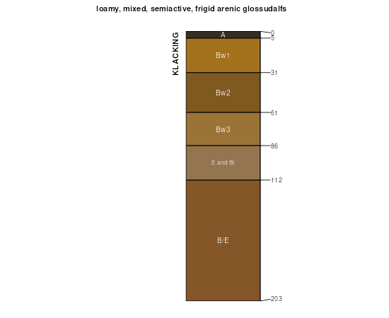
| Klacking-McGinn loamy sands, 8 to 50 percent slopes, dissected | 94F | 24737 | 190385 | 6d3g | mi001 | 1993 | 1:20000 |
Klacking loamy sand, 6 to 12 percent slopes | 31C | 10120 | 190314 | 6d15 | mi001 | 1993 | 1:20000 |
Klacking loamy sand, 0 to 6 percent slopes | 31B | 6130 | 190313 | 6d14 | mi001 | 1993 | 1:20000 |
Klacking loamy sand, 12 to 18 percent slopes | 31D | 4121 | 190315 | 6d16 | mi001 | 1993 | 1:20000 |
Klacking-McGinn loamy sands, 0 to 6 percent slopes | 92B | 2448 | 190383 | 6d3d | mi001 | 1993 | 1:20000 |
Klacking loamy sand, 18 to 35 percent slopes | 31E | 248 | 190316 | 6d17 | mi001 | 1993 | 1:20000 |
Klacking loamy sand, 0 to 6 percent slopes | 31B | 3594 | 191267 | 6f0x | mi007 | 1998 | 1:12000 |
Klacking loamy sand, 6 to 12 percent slopes | 31C | 2709 | 191268 | 6f0y | mi007 | 1998 | 1:12000 |
Klacking loamy sand, 18 to 35 percent slopes | 31E | 2321 | 191325 | 6f2s | mi007 | 1998 | 1:12000 |
Klacking-McGinn loamy sands, 8 to 50 percent slopes, dissected | 94F | 2273 | 191313 | 6f2d | mi007 | 1998 | 1:12000 |
Klacking loamy sand, 12 to 18 percent slopes | 31D | 1150 | 191269 | 6f0z | mi007 | 1998 | 1:12000 |
Klacking-McGinn loamy sands, 6 to 12 percent slopes | 92C | 371 | 191354 | 6f3q | mi007 | 1998 | 1:12000 |
Klacking-McGinn loamy sands, 0 to 6 percent slopes | 92B | 242 | 191348 | 6f3j | mi007 | 1998 | 1:12000 |
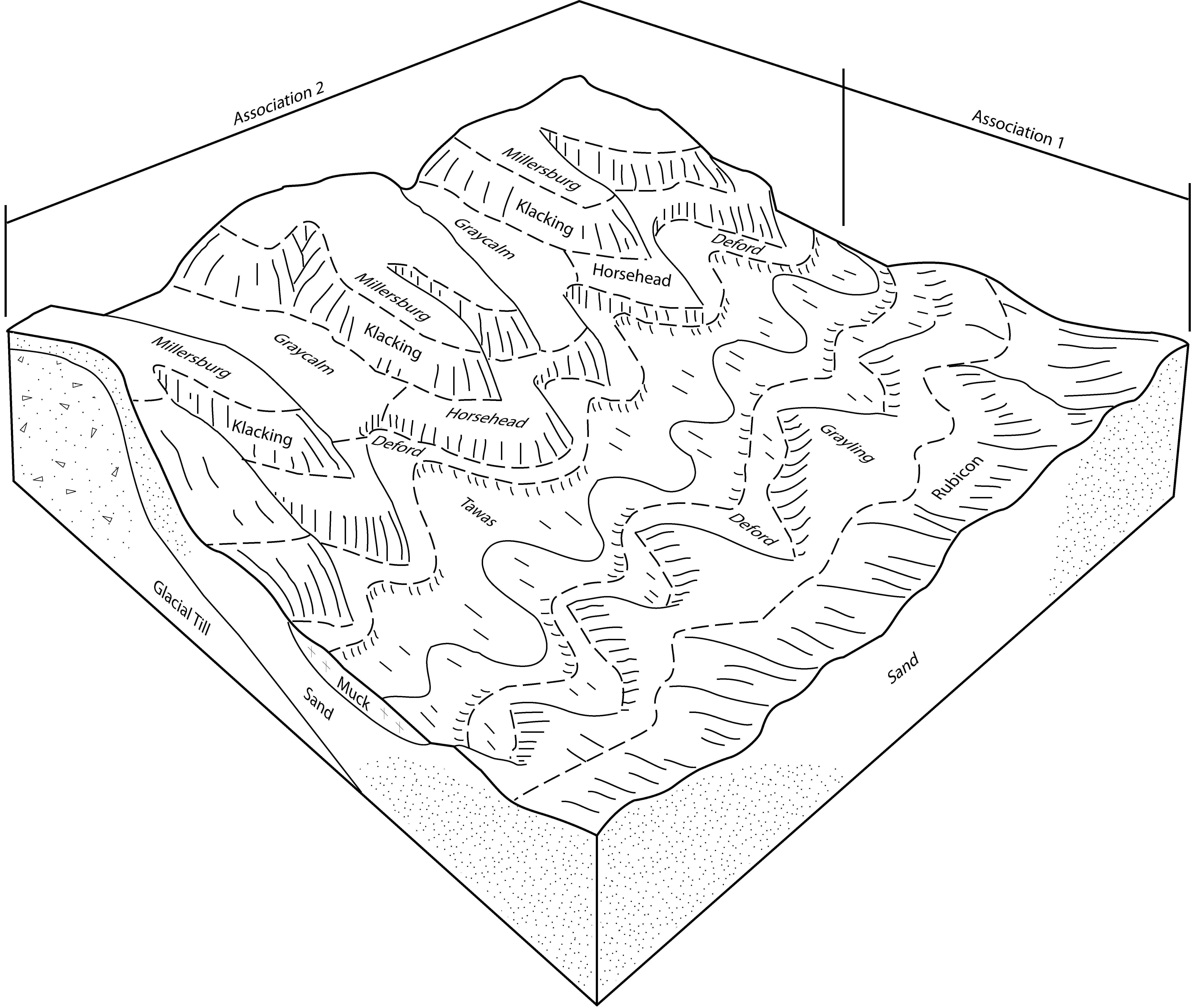
Graycalm-Klacking complex, 0 to 6 percent slopes | 21B | 11703 | 189678 | 6ccn | mi039 | 1993 | 1:15840 |
Klacking loamy sand, 0 to 6 percent slopes | 31B | 4981 | 189710 | 6cdp | mi039 | 1993 | 1:15840 |
Graycalm-Klacking complex, 6 to 18 percent slopes | 21D | 1229 | 189679 | 6ccp | mi039 | 1993 | 1:15840 |
Graycalm-Klacking complex, 8 to 45 percent slopes | 21F | 309 | 189680 | 6ccq | mi039 | 1993 | 1:15840 |
Klacking sand, 6 to 18 percent slopes | 123D | 17 | 191704 | 6fh0 | mi069 | 1995 | 1:15840 |
Graycalm-Klacking complex, 0 to 6 percent slopes | 21B | 7318 | 190638 | 6dcm | mi079 | 1998 | 1:12000 |
Graycalm-Klacking complex, 6 to 18 percent slopes | 21D | 1066 | 190639 | 6dcn | mi079 | 1998 | 1:12000 |
Graycalm-Klacking complex, 18 to 45 percent slopes | 21F | 234 | 190695 | 6dfg | mi079 | 1998 | 1:12000 |
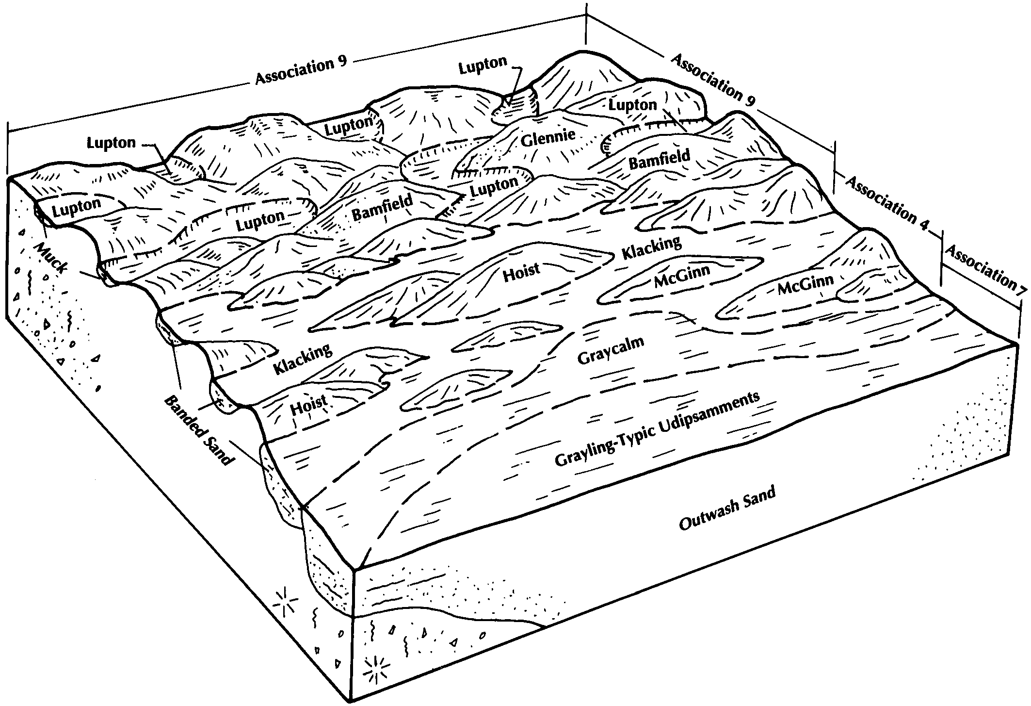
Millersburg-Klacking-Graycalm complex, 0 to 6 percent slopes | 388B | 10755 | 192272 | 6g2b | mi119 | 1997 | 1:12000 |
Millersburg-Klacking-Graycalm complex, 6 to 18 slopes | 388D | 9247 | 192273 | 6g2c | mi119 | 1997 | 1:12000 |
Klacking sand, 0 to 6 percent slopes | 307B | 8605 | 192236 | 6g15 | mi119 | 1997 | 1:12000 |
Klacking sand, 6 to 18 percent slopes | 123D | 8387 | 192179 | 6fzb | mi119 | 1997 | 1:12000 |
Millersburg-Klacking-Graycalm complex, 18 to 35 percent slopes | 388E | 3038 | 192274 | 6g2d | mi119 | 1997 | 1:12000 |
Klacking sand, 18 to 35 percent slopes | 307E | 1964 | 192237 | 6g16 | mi119 | 1997 | 1:12000 |
Klacking-McGinn loamy sands, 8 to 50 percent slopes, dissected | 94F | 166 | 192345 | 6g4p | mi119 | 1997 | 1:12000 |
Klacking sand, 35 to 70 percent slopes | 307F | 129 | 192238 | 6g17 | mi119 | 1997 | 1:12000 |
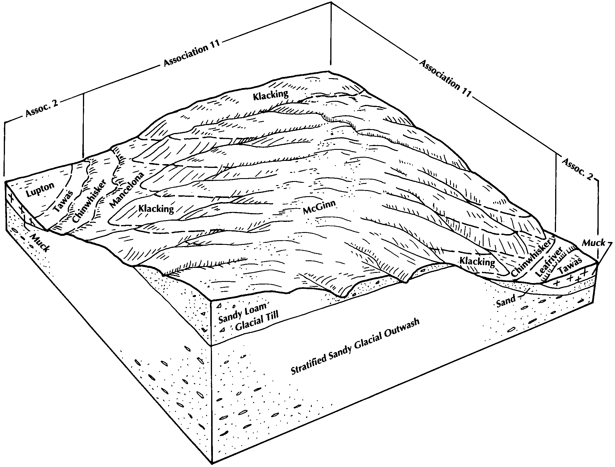
Klacking sand, 0 to 6 percent slopes | 18B | 5031 | 189880 | 6cl5 | mi129 | 1987 | 1:15840 |
Klacking sand, 6 to 18 percent slopes | 18C | 4335 | 189881 | 6cl6 | mi129 | 1987 | 1:15840 |
Klacking sand, 18 to 35 percent slopes | 18E | 1240 | 189882 | 6cl7 | mi129 | 1987 | 1:15840 |
Klacking-Isabella complex, 12 to 18 percent slopes | 93D | 1166 | 189964 | 6cnw | mi129 | 1987 | 1:15840 |
Klacking-Isabella complex, 6 to 12 percent slopes | 93C | 777 | 189963 | 6cnv | mi129 | 1987 | 1:15840 |
Klacking-Isabella complex, 18 to 25 percent slopes | 93E | 719 | 189965 | 6cnx | mi129 | 1987 | 1:15840 |
Graycalm-Klacking sands, 6 to 18 percent slopes | 475D | 12677 | 209066 | 70k2 | mi135 | 2003 | 1:12000 |
Graycalm-Klacking sands, 0 to 6 percent slopes | 475B | 11898 | 209065 | 70k1 | mi135 | 2003 | 1:12000 |
Millersburg-Klacking-Graycalm complex, 0 to 6 percent slopes | 388B | 5020 | 209043 | 70jb | mi135 | 2003 | 1:12000 |
Millersburg-Klacking-Graycalm complex, 6 to 18 percent slopes | 388D | 4535 | 209044 | 70jc | mi135 | 2003 | 1:12000 |
Klacking sand, 0 to 6 percent slopes | 307B | 2975 | 241420 | 836r | mi135 | 2003 | 1:12000 |
Klacking-Perecheney sands, 0 to 6 percent slopes | 476B | 2624 | 268401 | 9093 | mi135 | 2003 | 1:12000 |
Graycalm-Klacking sands, 18 to 35 percent slopes | 475E | 1640 | 209069 | 70k5 | mi135 | 2003 | 1:12000 |
Millersburg-Klacking-Graycalm complex, 18 to 35 percent slopes | 388E | 773 | 209045 | 70jd | mi135 | 2003 | 1:12000 |
Klacking sand, 6 to 18 percent slopes | 123D | 424 | 241428 | 8370 | mi135 | 2003 | 1:12000 |
Klacking-Perecheney sands, 6 to 18 percent slopes | 476D | 378 | 628182 | p2ny | mi135 | 2003 | 1:12000 |
Klacking sand, 18 to 35 percent slopes | 307E | 86 | 209038 | 70j5 | mi135 | 2003 | 1:12000 |
Klacking loamy sand, 0 to 6 percent slopes | 31B | 55 | 241355 | 834n | mi135 | 2003 | 1:12000 |
Klacking loamy sand, 6 to 12 percent slopes | 31C | 17 | 241356 | 834p | mi135 | 2003 | 1:12000 |
Klacking loamy sand, 12 to 18 percent slopes | 31D | 16 | 241357 | 834q | mi135 | 2003 | 1:12000 |
Klacking-McGinn loamy sands, 8 to 50 percent slopes, dissected | 94F | 15 | 241371 | 8355 | mi135 | 2003 | 1:12000 |
Graycalm-Klacking complex, 6 to 18 percent slopes | 21D | 8 | 241386 | 835n | mi135 | 2003 | 1:12000 |
Klacking sand, 0 to 6 percent slopes | 4B | 3596 | 190904 | 6dn6 | mi141 | 1989 | 1:15840 |
Klacking sand, 6 to 12 percent slopes | 4C | 1382 | 190905 | 6dn7 | mi141 | 1989 | 1:15840 |
Graycalm-Klacking sands, 0 to 6 percent slopes | 475B | 13655 | 191025 | 6ds3 | mi143 | 1999 | 1:12000 |
Klacking sand, 0 to 6 percent slopes | 307B | 6261 | 191015 | 6drs | mi143 | 1999 | 1:12000 |
Graycalm-Klacking sands, 6 to 18 percent slopes | 475D | 5007 | 191026 | 6ds4 | mi143 | 1999 | 1:12000 |
Klacking-Perecheney sands, 0 to 6 percent slopes | 476B | 3284 | 190977 | 6dqk | mi143 | 1999 | 1:12000 |
Graycalm-Klacking sands, 18 to 35 percent slopes | 475E | 1329 | 191027 | 6ds5 | mi143 | 1999 | 1:12000 |
Klacking-Perecheney sands, 6 to 18 percent slopes | 476D | 982 | 191040 | 6dsl | mi143 | 1999 | 1:12000 |
Klacking sand, 6 to 18 percent slopes | 123D | 832 | 191011 | 6drn | mi143 | 1999 | 1:12000 |
Klacking sand, 18 to 35 percent slopes | 307E | 394 | 191016 | 6drt | mi143 | 1999 | 1:12000 |
