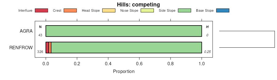
| Kirkland-Renfrow clay loams, 1 to 3 percent slopes | 6360 | 17982 | 1382702 | 30x0w | ks077 | 1965 | 1:24000 |
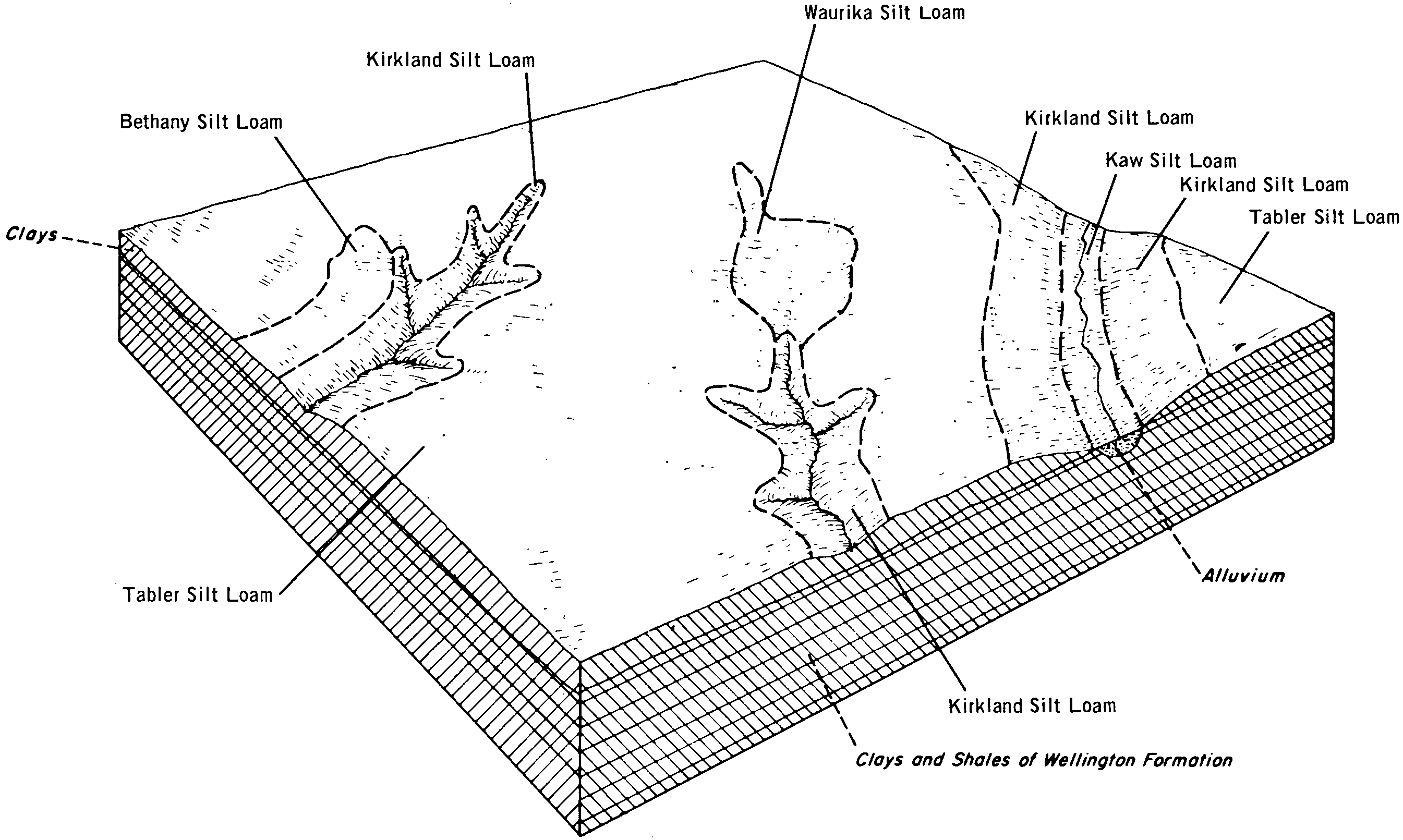
Kirkland silt loam, 0 to 1 percent slopes, cool | 6354 | 5065 | 1382701 | 2rj92 | ks077 | 1965 | 1:24000 |
Kirkland-Renfrow soils, 1 to 3 percent slopes, eroded | 6362 | 3532 | 1382703 | 1hdtb | ks077 | 1965 | 1:24000 |
Kirkland-Renfrow clay loams, 1 to 3 percent slopes | 6360 | 219 | 1444828 | 30x0w | ks095 | 1977 | 1:24000 |
Kirkland silt loam, 1 to 3 percent slopes | 6356 | 55675 | 1444652 | 2td60 | ks191 | 1974 | 1:24000 |
Kirkland silt loam, 0 to 1 percent slopes, cool | 6354 | 17118 | 1444651 | 2rj92 | ks191 | 1974 | 1:24000 |
Kirkland silty clay loam, 1 to 3 percent slopes, eroded | 6358 | 4865 | 1444653 | 1kh8q | ks191 | 1974 | 1:24000 |
Kirkland-Renfrow clay loams, 1 to 3 percent slopes | 6360 | 523 | 1444654 | 30x0w | ks191 | 1974 | 1:24000 |
Kirkland-Renfrow soils, 1 to 3 percent slopes, eroded | 6362 | 47 | 1444655 | 1kh8s | ks191 | 1974 | 1:24000 |
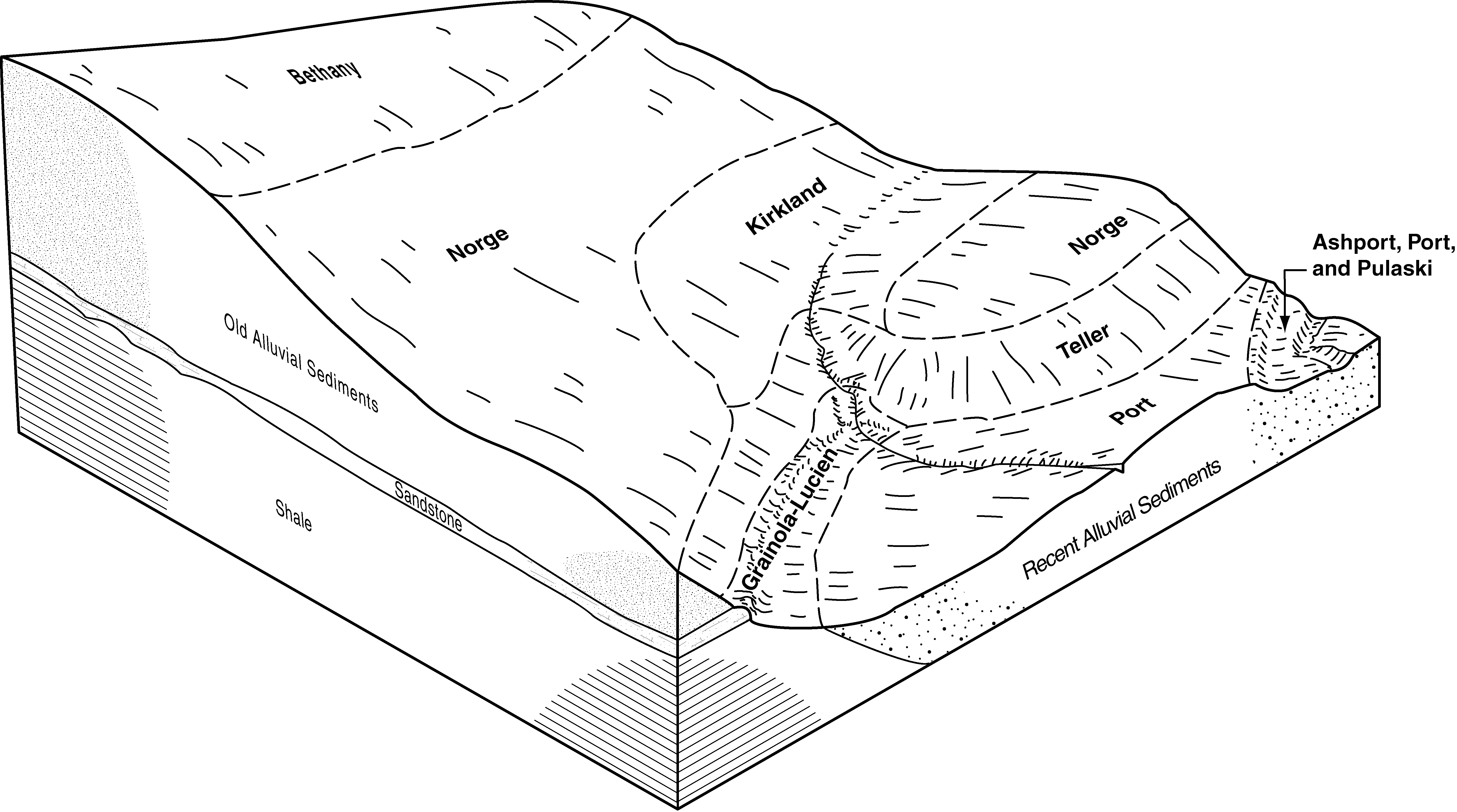
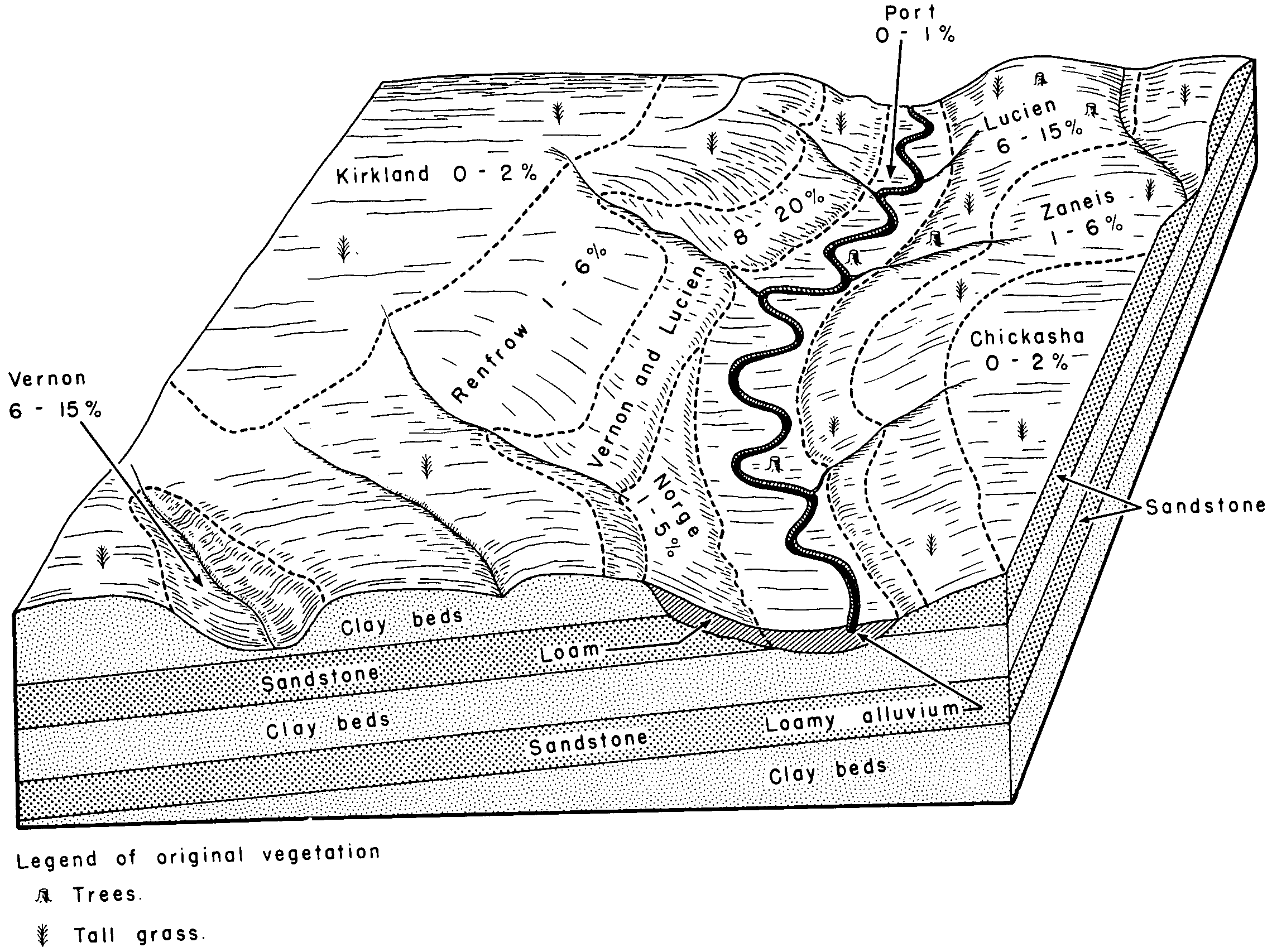
Kirkland silt loam, 0 to 1 percent slopes | KrA | 10653 | 381736 | 2rj95 | ok011 | 1965 | 1:24000 |
Kirkland silt loam, 0 to 1 percent slopes | KrA | 13141 | 381953 | 2rj95 | ok017 | 1972 | 1:24000 |
Kirkland silt loam, 1 to 3 percent slopes | KrB | 11538 | 381954 | 2td60 | ok017 | 1972 | 1:24000 |
Kirkland-Pawhuska complex, 0 to 3 percent slopes | KsB | 3202 | 381955 | 2tp58 | ok017 | 1972 | 1:24000 |
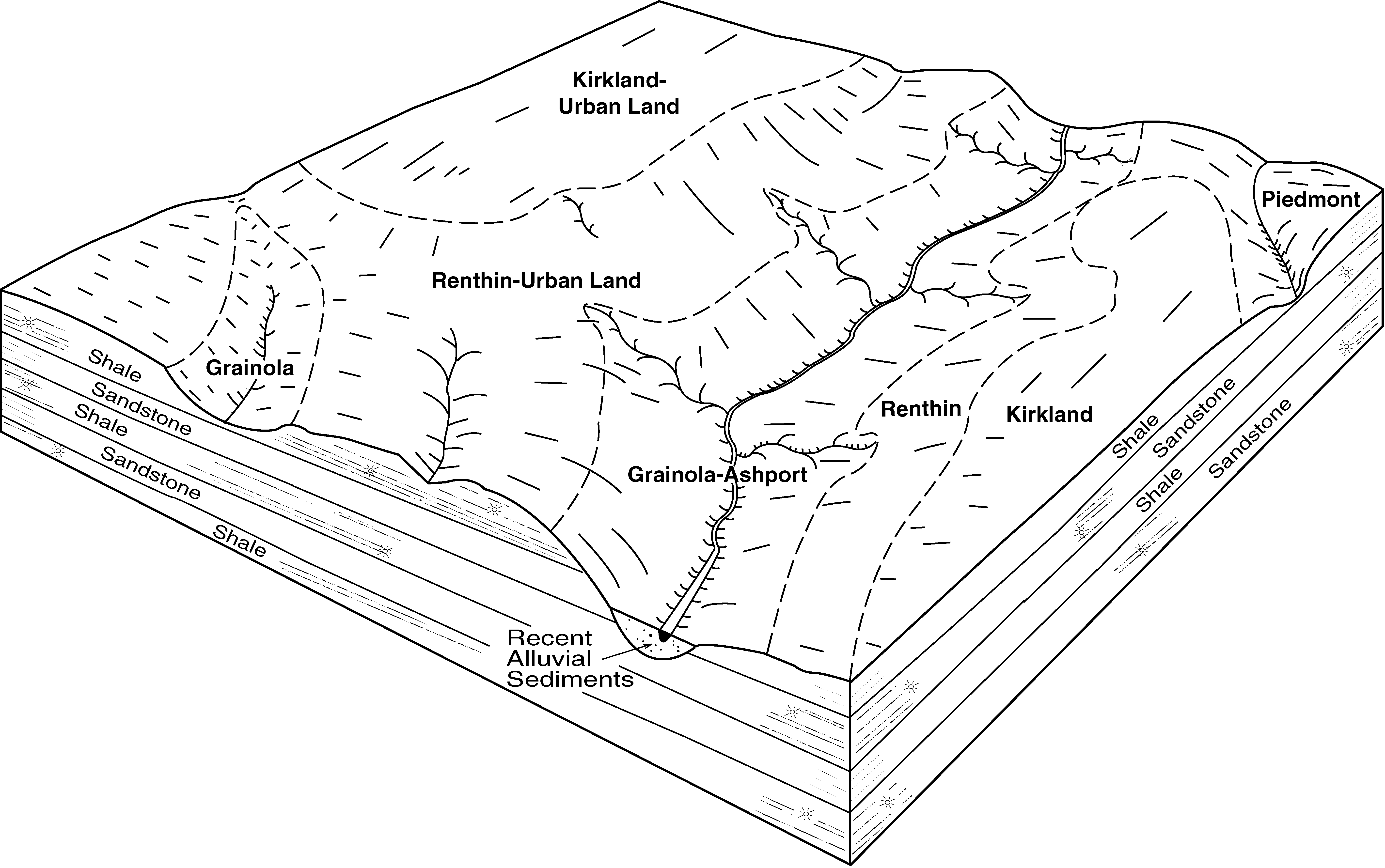
Kirkland silt loam, 0 to 1 percent slopes | 50 | 6090 | 382113 | 2rj95 | ok027 | 1984 | 1:24000 |
Kirkland-Urban land-Pawhuska complex, 0 to 3 percent slopes | 49 | 5547 | 382111 | dtm5 | ok027 | 1984 | 1:24000 |
Kirkland-Pawhuska complex, 0 to 3 percent slopes | 51 | 4579 | 382114 | 2tp58 | ok027 | 1984 | 1:24000 |
Kirkland-Pawhuska complex, 0 to 3 percent slopes, eroded | 53 | 4113 | 382116 | dtmb | ok027 | 1984 | 1:24000 |
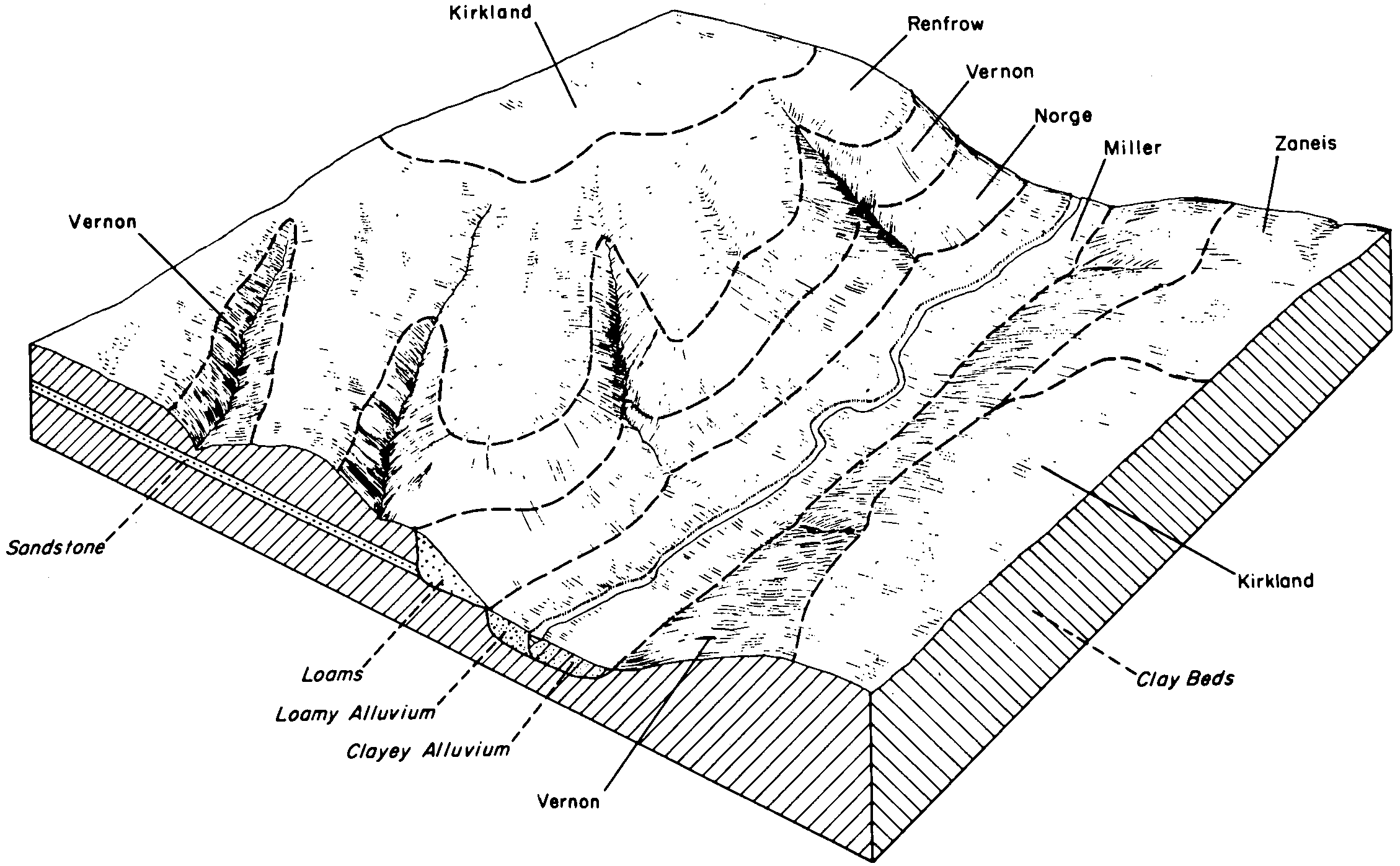
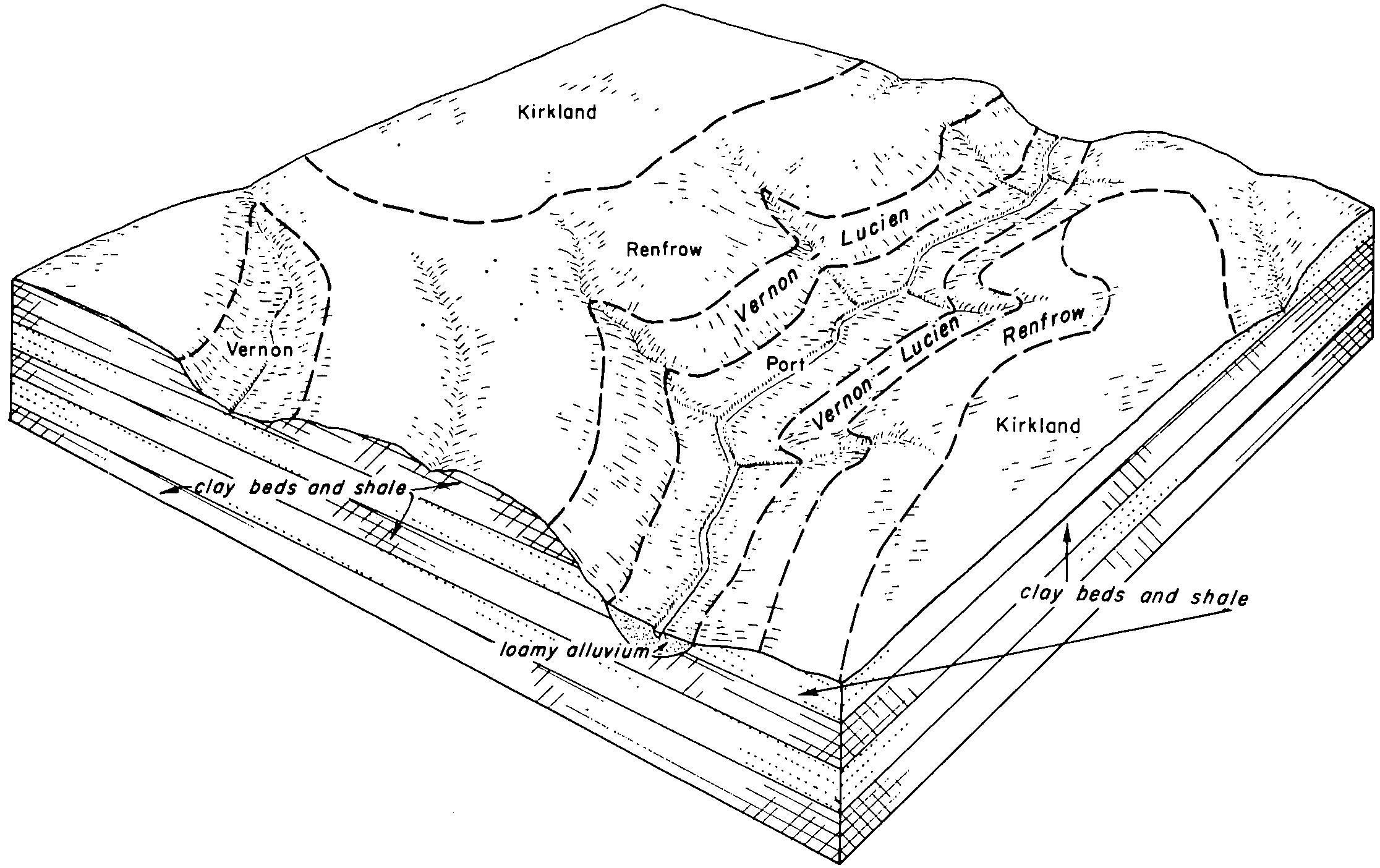
Kirkland-Renfrow complex, 1 to 3 percent slopes | KrB | 96816 | 382501 | 2tp5r | ok047 | 1965 | 1:24000 |
Kirkland silt loam, 0 to 1 percent slopes, cool | KnA | 65424 | 382500 | 2rj92 | ok047 | 1965 | 1:24000 |
Kirkland-Pawhuska complex, 0 to 3 percent slopes | KsA | 5078 | 382502 | 2tp58 | ok047 | 1965 | 1:24000 |
Kirkland silt loam, 0 to 1 percent slopes | 17 | 8508 | 382635 | 2rj95 | ok051 | 1975 | 1:24000 |
Kirkland silt loam, 1 to 3 percent slopes | KrdB | 100064 | 2628668 | 2td60 | ok053 | 1983 | 1:24000 |
Kirkland silt loam, 0 to 1 percent slopes, cool | 29 | 58322 | 382717 | 2rj92 | ok053 | 1983 | 1:24000 |
Kirkland-Pawhuska complex, 0 to 3 percent slopes | 31 | 14116 | 382720 | 2tp58 | ok053 | 1983 | 1:24000 |
Kirkland silt loam, 1 to 3 percent slopes | KnB | 9241 | 383229 | 2td60 | ok067 | 1967 | 1:24000 |
Kirkland silt loam, 0 to 1 percent slopes, warm | KldA | 7794 | 2784839 | 2rj9t | ok067 | 1967 | 1:24000 |
Kirkland silt loam, 1 to 3 percent slopes | KnB | 95817 | 383333 | 2td60 | ok071 | 1965 | 1:24000 |
Kirkland-Renfrow complex, 3 to 5 percent slopes, eroded | KrC2 | 41437 | 383334 | dvwm | ok071 | 1965 | 1:24000 |
Renfrow-Kirkland complex, 3 to 5 percent slopes | RkC | 5823 | 383363 | dvxk | ok071 | 1965 | 1:24000 |
Kirkland silt loam, 0 to 1 percent slopes, cool | KrdA | 218 | 623478 | 2rj92 | ok071 | 1965 | 1:24000 |
Kirkland silt loam, 0 to 1 percent slopes | KrA | 4210 | 383398 | 2rj95 | ok073 | 1960 | 1:24000 |
Kirkland silt loam, 0 to 1 percent slopes | KnA | 1697 | 383512 | 2rj95 | ok081 | 1966 | 1:24000 |
Kirkland silty clay loam, 1 to 3 percent slopes | KrkB | 9870 | 383638 | dw6f | ok083 | 1994 | 1:12000 |
Kirkland silt loam, 0 to 1 percent slopes | KrdA | 4086 | 383637 | 2rj95 | ok083 | 1994 | 1:12000 |
Kirkland silt loam, 1 to 3 percent slopes | 21 | 7327 | 383777 | 2td60 | ok087 | 1976 | 1:24000 |
Kirkland silt loam, 0 to 1 percent slopes, cool | KrA | 4400 | 383833 | 2rj92 | ok093 | 1965 | 1:24000 |
Kirkland silt loam, 1 to 3 percent slopes | KrdB | 19281 | 384075 | 2td60 | ok103 | 1994 | 1:24000 |
Kirkland silt loam, 1 to 3 percent slopes, eroded | KrdB2 | 12252 | 384076 | dwnk | ok103 | 1994 | 1:24000 |
Kirkland silt loam, 0 to 1 percent slopes, cool | KrdA | 10851 | 384074 | 2rj92 | ok103 | 1994 | 1:24000 |
Kirkland-Pawhuska complex, 0 to 3 percent slopes | KrPB | 4484 | 384073 | 2tp58 | ok103 | 1994 | 1:24000 |
Kirkland-Urban land complex, 0 to 1 percent slopes | KrUA | 9616 | 384318 | dwxc | ok109 | 1996 | 1:12000 |
Kirkland silt loam, 0 to 1 percent slopes | KrdA | 8923 | 384319 | 2rj95 | ok109 | 1996 | 1:12000 |
Kirkland silt loam, 1 to 3 percent slopes | KrdB | 1620 | 1423161 | 2td60 | ok117 | 2007 | 1:24000 |
Kirkland silt loam, 1 to 3 percent slopes, eroded | KrdB2 | 1125 | 1677318 | 1t9d1 | ok117 | 2007 | 1:24000 |
Kirkland silt loam, 0 to 1 percent slopes, cool | KrdA | 953 | 1423160 | 2rj92 | ok117 | 2007 | 1:24000 |
Kirkland-Pawhuska complex, 0 to 3 percent slopes | KrPB | 76 | 1677319 | 2tp58 | ok117 | 2007 | 1:24000 |
Kirkland silt loam, 1 to 3 percent slopes | KrdB | 4266 | 1907384 | 2td60 | ok119 | 1983 | 1:24000 |
Kirkland silt loam, 0 to 1 percent slopes | 22 | 1156 | 384682 | 2rj95 | ok125 | 1975 | 1:24000 |
Kirkland-Renfrow complex, 1 to 3 percent slopes | KrB | 23794 | 384866 | 2tp5r | ok137 | 1960 | 1:24000 |
Kirkland silt loam, 0 to 1 percent slopes, warm | KldA | 8154 | 384865 | 2rj9t | ok137 | 1960 | 1:24000 |
Renfrow and Kirkland soils, 1 to 5 percent slopes, eroded | RfB2 | 4764 | 384880 | dxhh | ok137 | 1960 | 1:24000 |
Renfrow-Kirkland-Anocon association, nearly level | 45 | 85489 | 363899 | d6np | tx077 | 1977 | 1:24000 |
Kirkland silt loam, 0 to 1 percent slopes, warm | 27 | 2079 | 363879 | 2rj9t | tx077 | 1977 | 1:24000 |
Kirkland silt loam, 0 to 1 percent slopes, warm | KrA | 1100 | 373362 | 2rj9t | tx485 | 1972 | 1:20000 |
Kirkland silt loam, 1 to 3 percent slopes | KrB | 694 | 373363 | 2td60 | tx485 | 1972 | 1:20000 |


