| Kirby-Cabbart complex, 8 to 25 percent slopes | 176D | 1840 | 342970 | chwk | mt011 | 1992 | 1:24000 |
Kirby-Blacksheep-Rock outcrop complex, 25 to 60 percent slopes | 276F | 571 | 343065 | 2xrs8 | mt011 | 1992 | 1:24000 |
Rock outcrop-Cabbart-Kirby complex, 25 to 70 percent slopes | 691F | 5525 | 343649 | cjlg | mt017 | 1995 | 1:24000 |
Cambeth, calcareous-Cabbart-Kirby complex, 8 to 45 percent slopes | 293E | 5022 | 343376 | 2zg5l | mt017 | 1995 | 1:24000 |
Armells-Kirby-Cabbart complex, 25 to 70 percent slopes, stony | 151F | 2766 | 343319 | 2yk03 | mt017 | 1995 | 1:24000 |
Kirby-Cabbart-Rock outcrop complex, 25 to 70 percent slopes | 943F | 504 | 343764 | cjq5 | mt017 | 1995 | 1:24000 |
Armells-Kirby complex, 25 to 70 percent slopes | 912F | 137 | 343739 | 2zg6j | mt017 | 1995 | 1:24000 |
Kirby-Blacksheep-Rock outcrop complex, 25 to 60 percent slopes | 612F | 32 | 343581 | 2xrs8 | mt017 | 1995 | 1:24000 |
Birney-Cooers-Kirby complex, 2 to 15 percent slopes | 913D | 24 | 343741 | cjpf | mt017 | 1995 | 1:24000 |
Lambert-Kirby complex, 15 to 65 percent slopes | Lr | 26531 | 342021 | cgwy | mt021 | 1971 | 1:24000 |
Kirby-Cabbart complex, 8 to 25 percent slopes | 176D | 9239 | 3040367 | ch0k | mt025 | 1991 | 1:24000 |
Kirby-Blacksheep-Rock outcrop complex, 25 to 60 percent slopes | 276F | 8441 | 342184 | 2xrs8 | mt025 | 1991 | 1:24000 |
Cooers-Kirby-Rock outcrop complex, 8 to 25 percent slopes | 8E | 4934 | 342309 | ch67 | mt025 | 1991 | 1:24000 |
Delpoint-Cooers-Kirby complex, 15 to 35 percent slopes | 371E | 1547 | 342215 | ch36 | mt025 | 1991 | 1:24000 |
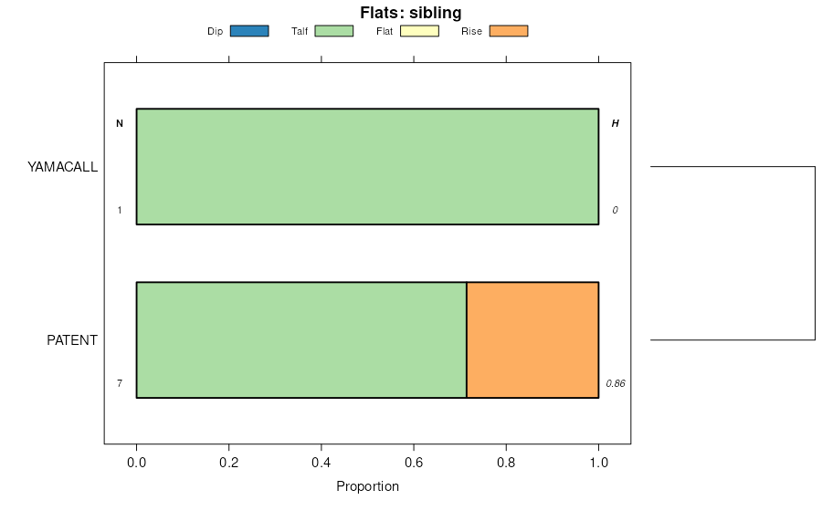
Kirby-Badland-Patent complex, 9 to 70 percent slopes | L3007F | 605 | 3223493 | 2q2mw | mt025 | 1991 | 1:24000 |
Lonna-Kirby-Cabbart complex, 2 to 50 percent slopes | L3025F | 580 | 342133 | 2q383 | mt025 | 1991 | 1:24000 |
Cambeth, calcareous-Cabbart-Kirby complex, 8 to 45 percent slopes | 377E | 2346 | 342641 | 2zg5l | mt033 | 2002 | 1:24000 |
Cambeth-Cabbart-Kirby complex, 4 to 15 percent slopes | 377D | 2028 | 342640 | chjx | mt033 | 2002 | 1:24000 |
Cabbart-Kirby complex, 8 to 45 percent slopes | 33 | 7423 | 344395 | ckcj | mt055 | 1981 | 1:24000 |
Yawdim-Kirby complex, 8 to 35 percent slopes | 167 | 490 | 344368 | ckbn | mt055 | 1981 | 1:24000 |
Cambeth, calcareous-Cabbart-Kirby complex, 8 to 45 percent slopes | 25 | 15595 | 344845 | 2zg5l | mt079 | 1986 | 1:24000 |
Rock outcrop-Cabbart-Kirby complex, 25 to 70 percent slopes | 109 | 3623 | 344785 | cks3 | mt079 | 1986 | 1:24000 |
Neldore-Weingart-Kirby complex, 4 to 25 percent slopes | 99 | 989 | 345055 | cl1t | mt079 | 1986 | 1:24000 |
Lonna-Kirby-Cabbart complex, 2 to 50 percent slopes | L3025F | 373 | 345612 | 2q383 | mt109 | 1956 | 1:31680 |
Kirby-Cabbart-Blacksheep complex, wooded, 6 to 45 percent slopes | 294 | 6995 | 1387767 | 1hl2p | mt643 | 1967 | 1:20000 |
Armells-Kirby-Cabbart complex, 25 to 70 percent slopes, stony | 10 | 37660 | 347920 | 2yk03 | mt649 | 1985 | 1:24000 |
Kirby-Cabbart-Rock outcrop complex, 25 to 70 percent slopes | 108 | 26063 | 347929 | cp1j | mt649 | 1985 | 1:24000 |
Birney-Kirby channery loams, 4 to 25 percent slopes | 19 | 18627 | 348019 | cp4f | mt649 | 1985 | 1:24000 |
Birney-Cooers-Kirby complex, 2 to 15 percent slopes | 18 | 9484 | 348008 | cp42 | mt649 | 1985 | 1:24000 |
Birney, moist-Birney-Kirby channery loams, 15 to 25 percent slopes | 22 | 9350 | 348051 | cp5g | mt649 | 1985 | 1:24000 |
Birney-Kirby-Cabbart complex, 15 to 25 percent slopes | 20 | 6707 | 348031 | cp4t | mt649 | 1985 | 1:24000 |
Armells-Kirby complex, 25 to 70 percent slopes | 9 | 6490 | 348125 | 2zg6j | mt649 | 1985 | 1:24000 |
Cambeth, calcareous-Cabbart-Kirby complex, 8 to 45 percent slopes | 218 | 920 | 361372 | 2zg5l | mt649 | 1985 | 1:24000 |
Lonna-Kirby-Cabbart complex, 2 to 50 percent slopes | L3025F | 35690 | 2707055 | 2q383 | nd007 | 1998 | 1:24000 |
Kirby-Badland-Patent complex, 9 to 70 percent slopes | L3007F | 11930 | 2707053 | 2q2mw | nd007 | 1998 | 1:24000 |
Gerda-Kirby complex, 2 to 15 percent slopes | L3015D | 7207 | 2707054 | 2qxl9 | nd007 | 1998 | 1:24000 |
Kirby-Arikara-Badland complex, 9 to 70 percent slopes | L3104F | 4391 | 2707057 | 2q2mz | nd007 | 1998 | 1:24000 |
Kirby-Scairt complex, 9 to 70 percent slopes | L3013F | 50 | 2758439 | 2q2mx | nd007 | 1998 | 1:24000 |
Lonna-Kirby-Cabbart complex, 2 to 50 percent slopes | L3025F | 27 | 2563483 | 2q383 | nd011 | 1969 | 1:20000 |
Kirby-Scairt complex, 9 to 70 percent slopes | L3013F | 142 | 2758499 | 2q2mx | nd025 | 1981 | 1:20000 |
Kirby-Badland-Patent complex, 9 to 70 percent slopes | L3007F | 73 | 2758498 | 2q2mw | nd025 | 1981 | 1:20000 |
Lonna-Kirby-Cabbart complex, 2 to 50 percent slopes | L3025F | 25029 | 2707336 | 2q383 | nd033 | 1985 | 1:24000 |
Kirby-Badland-Patent complex, 9 to 70 percent slopes | L3007F | 35 | 2759765 | 2q2mw | nd033 | 1985 | 1:24000 |
Gerda-Kirby complex, 2 to 15 percent slopes | L3015D | 6 | 2759766 | 2qxl9 | nd033 | 1985 | 1:24000 |
Kirby-Badland-Patent complex, 9 to 70 percent slopes | L3007F | 16035 | 2715133 | 2q2mw | nd053 | 2003 | 1:24000 |
Kirby-Scairt complex, 9 to 70 percent slopes | L3013F | 7461 | 2715134 | 2q2mx | nd053 | 2003 | 1:24000 |
Kirby-Arikara-Badland complex, 9 to 70 percent slopes | L3104F | 3362 | 2715135 | 2q2mz | nd053 | 2003 | 1:24000 |
Lonna-Kirby-Cabbart complex, 2 to 50 percent slopes | L3025F | 3013 | 2715138 | 2q383 | nd053 | 2003 | 1:24000 |
Gerda-Kirby complex, 2 to 15 percent slopes | L3015D | 1273 | 2715153 | 2qxl9 | nd053 | 2003 | 1:24000 |
Lonna-Kirby-Cabbart complex, 2 to 50 percent slopes | L3025F | 20001 | 2715928 | 2q383 | nd087 | 1974 | 1:20000 |
Gerda-Kirby complex, 2 to 15 percent slopes | L3015D | 85 | 2758538 | 2qxl9 | nd087 | 1974 | 1:20000 |
Kirby-Badland-Patent complex, 9 to 70 percent slopes | L3007F | 71 | 2758536 | 2q2mw | nd087 | 1974 | 1:20000 |
Kirby-Scairt complex, 9 to 70 percent slopes | L3013F | 5 | 2758537 | 2q2mx | nd087 | 1974 | 1:20000 |
Kirby-Cabbart-Rock outcrop complex, 15 to 60 percent slopes | KcF | 3441 | 355755 | cy5z | sd063 | 1984 | 1:24000 |
Kirby-Cabbart-Blacksheep complex, wooded, 6 to 45 percent slopes | 294 | 22219 | 817633 | wft8 | wy705 | 2003 | 1:24000 |
Bonfri-Kirby complex, 0 to 10 percent slopes | 258 | 732 | 817555 | wfqr | wy705 | 2003 | 1:24000 |