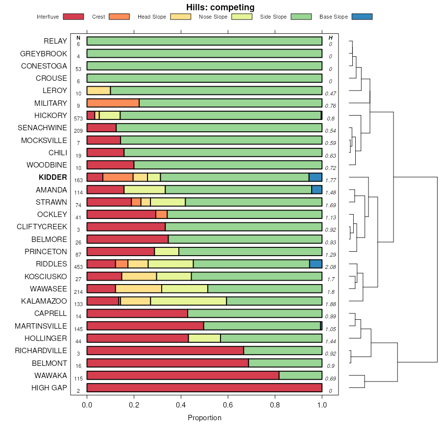
| Kidder loam, 6 to 12 percent slopes, eroded | 361D2 | 2562 | 1019390 | 2tjyb | il007 | 2006 | 1:12000 |
Kidder loam, 4 to 6 percent slopes, eroded | 361C2 | 1191 | 1019389 | 2tjyg | il007 | 2006 | 1:12000 |
Kidder loam, 2 to 4 percent slopes | 361B | 362 | 1019388 | 2tjyc | il007 | 2006 | 1:12000 |
Kidder clay loam, 6 to 12 percent slopes, severely eroded | 361D3 | 252 | 1019391 | 136rl | il007 | 2006 | 1:12000 |
Kidder loam, 12 to 20 percent slopes, eroded | 361E2 | 92 | 1407180 | 2tjyd | il007 | 2006 | 1:12000 |
Kidder loam, 2 to 4 percent slopes | 361B | 736 | 2108759 | 2tjyc | il031 | 2008 | 1:12000 |
Kidder loam, 4 to 6 percent slopes, eroded | 361C2 | 589 | 2108760 | 2tjyg | il031 | 2008 | 1:12000 |
Kidder loam, 6 to 12 percent slopes, eroded | 361D2 | 277 | 2108761 | 2tjyb | il031 | 2008 | 1:12000 |
Kidder loam, 12 to 20 percent slopes, eroded | 361E2 | 72 | 2108762 | 2tjyd | il031 | 2008 | 1:12000 |
Kidder loam, 2 to 4 percent slopes | 361B | 459 | 198849 | 2tjyc | il089 | 2000 | 1:12000 |
Kidder loam, 4 to 6 percent slopes, eroded | 361C2 | 305 | 198850 | 2tjyg | il089 | 2000 | 1:12000 |
Kidder loam, 12 to 20 percent slopes, eroded | 361E2 | 190 | 271500 | 2tjyd | il089 | 2000 | 1:12000 |
Kidder loam, 6 to 12 percent slopes, eroded | 361D2 | 108 | 198851 | 2tjyb | il089 | 2000 | 1:12000 |
Kidder silt loam, 6 to 12 percent slopes, eroded | 361D2 | 727 | 929008 | 105q0 | il103 | 2004 | 1:12000 |
Kidder loam, 4 to 6 percent slopes, eroded | 361C2 | 10855 | 182665 | 2tjyg | il111 | 1997 | 1:12000 |
Kidder loam, 6 to 12 percent slopes, eroded | 361D2 | 5376 | 182668 | 2tjyb | il111 | 1997 | 1:12000 |
Kidder loam, 4 to 6 percent slopes | 361C | 2054 | 182664 | 2tjyh | il111 | 1997 | 1:12000 |
Kidder loam, 12 to 20 percent slopes | 361E | 1521 | 182670 | 642l | il111 | 1997 | 1:12000 |
Kidder clay loam, 6 to 12 percent slopes, severely eroded | 361D3 | 1491 | 182669 | 642k | il111 | 1997 | 1:12000 |
Kidder loam, 12 to 20 percent slopes, eroded | 361E2 | 1480 | 182671 | 2tjyd | il111 | 1997 | 1:12000 |
Kidder loam, 2 to 4 percent slopes | 361B | 898 | 182661 | 2tjyc | il111 | 1997 | 1:12000 |
Kidder silt loam, 20 to 30 percent slopes | 361F | 768 | 182673 | 642p | il111 | 1997 | 1:12000 |
Kidder clay loam, 4 to 6 percent slopes, severely eroded | 361C3 | 378 | 182666 | 642g | il111 | 1997 | 1:12000 |
Kidder loam, 6 to 12 percent slopes, eroded | 361D2 | 3905 | 1398980 | 2tjyb | il141 | 2005 | 1:12000 |
Kidder loam, 2 to 4 percent slopes | 361B | 589 | 1398979 | 2tjyc | il141 | 2005 | 1:12000 |
Kidder loam, 12 to 20 percent slopes, eroded | 361E2 | 477 | 1651461 | 2tjyd | il177 | 2006 | 1:12000 |
Kidder clay loam, 6 to 12 percent slopes, severely eroded | 361D3 | 354 | 1592017 | 1qfmd | il177 | 2006 | 1:12000 |
Kidder loam, 6 to 12 percent slopes, eroded | 361D2 | 5704 | 174052 | 2tjyb | il201 | 1997 | 1:12000 |
Kidder clay loam, 6 to 12 percent slopes, severely eroded | 361D3 | 454 | 1486992 | 1lxbh | il201 | 1997 | 1:12000 |
Kidder loam, 2 to 4 percent slopes | 361B | 257 | 174050 | 2tjyc | il201 | 1997 | 1:12000 |
Kidder fine sandy loam, 2 to 6 percent slopes | 2B | 4817 | 186976 | 68kh | mi023 | 1984 | 1:15840 |
Kidder fine sandy loam, 6 to 12 percent slopes | 2C | 703 | 186977 | 68kj | mi023 | 1984 | 1:15840 |
Kidder sandy loam, 2 to 6 percent slopes | KrB | 3614 | 191637 | 6fdv | mi161 | 1974 | 1:20000 |
Kidder sandy loam, 6 to 12 percent slopes | KrC | 3186 | 191638 | 6fdw | mi161 | 1974 | 1:20000 |
Boyer-Kidder complex, 15 to 35 percent slopes | BoE | 2698 | 191613 | 6fd2 | mi161 | 1974 | 1:20000 |
Kidder sandy loam, 12 to 18 percent slopes | KrD | 1503 | 191639 | 6fdx | mi161 | 1974 | 1:20000 |
Kidder loam, 12 to 20 percent slopes, eroded | 7361D2 | 12940 | 753528 | 2tjyd | wi025 | 1972 | 1:15840 |
Kidder loam, 6 to 12 percent slopes, eroded | 7361C2 | 8999 | 753527 | 2tjyb | wi025 | 1972 | 1:15840 |
Kidder soils, 20 to 35 percent slopes, eroded | 7961E2 | 6709 | 753532 | t93h | wi025 | 1972 | 1:15840 |
Dodge and Kidder soils, 6 to 20 percent slopes, eroded | 7724D2 | 2751 | 753483 | t91x | wi025 | 1972 | 1:15840 |
Kidder soils, 10 to 20 percent slopes, eroded | 7961D2 | 2529 | 753531 | t93g | wi025 | 1972 | 1:15840 |
Kidder loam, 2 to 6 percent slopes | 7361B | 774 | 753526 | 2tjy9 | wi025 | 1972 | 1:15840 |
Kidder loam, 20 to 30 percent slopes, eroded | 7361E2 | 4440 | 423592 | 2tjyj | wi027 | 1976 | 1:15840 |
Kidder loam, 6 to 12 percent slopes, eroded | 7361C2 | 1953 | 423590 | 2tjyb | wi027 | 1976 | 1:15840 |
Kidder loam, 12 to 20 percent slopes, eroded | 7361D2 | 1176 | 423591 | 2tjyd | wi027 | 1976 | 1:15840 |
Kidder loam, 2 to 6 percent slopes | 7361B | 989 | 423589 | 2tjy9 | wi027 | 1976 | 1:15840 |
Kidder fine sandy loam, 2 to 6 percent slopes | 7461B | 12758 | 423694 | g6wk | wi047 | 1974 | 1:20000 |
Kidder loam, 2 to 6 percent slopes | 7361B | 4639 | 423698 | 2tjy9 | wi047 | 1974 | 1:20000 |
Kidder fine sandy loam, 6 to 12 percent slopes, eroded | 7461C2 | 3757 | 423695 | g6wl | wi047 | 1974 | 1:20000 |
Kidder loam, 6 to 12 percent slopes, eroded | 7361C2 | 2117 | 423699 | 2tjyb | wi047 | 1974 | 1:20000 |
Kidder loam, 12 to 20 percent slopes, eroded | 7361D2 | 693 | 423700 | 2tjyd | wi047 | 1974 | 1:20000 |
Kidder fine sandy loam, 0 to 2 percent slopes | 7461A | 601 | 423693 | g6wj | wi047 | 1974 | 1:20000 |
Kidder fine sandy loam, 12 to 20 percent slopes, eroded | 7461D2 | 544 | 423696 | g6wm | wi047 | 1974 | 1:20000 |
Kidder loam, 20 to 30 percent slopes | 7361E | 294 | 423701 | g6ws | wi047 | 1974 | 1:20000 |
Kidder loam, 0 to 2 percent slopes | 7361A | 274 | 423697 | g6wn | wi047 | 1974 | 1:20000 |
Kidder loam, 6 to 12 percent slopes, eroded | 7361C2 | 15486 | 423799 | 2tjyb | wi055 | 1976 | 1:15840 |
Kidder loam, 2 to 6 percent slopes | 7361B | 11413 | 423798 | 2tjy9 | wi055 | 1976 | 1:15840 |
Kidder sandy loam, 2 to 6 percent slopes | 7461B | 5934 | 423796 | g6zv | wi055 | 1976 | 1:15840 |
Kidder loam, 12 to 20 percent slopes, eroded | 7361D2 | 5424 | 423800 | 2tjyd | wi055 | 1976 | 1:15840 |
Kidder sandy loam, 6 to 12 percent slopes, eroded | 7461C2 | 3861 | 423797 | g6zw | wi055 | 1976 | 1:15840 |
Kidder loam, moderately well drained, 2 to 6 percent slopes | 7367B | 3145 | 423801 | g700 | wi055 | 1976 | 1:15840 |
Kidder silt loam, 2 to 6 percent slopes, eroded | 7361B2 | 19899 | 426328 | g9mj | wi105 | 1970 | 1:20000 |
Kidder silt loam, 6 to 12 percent slopes, eroded | 7361C2 | 18383 | 426329 | g9mk | wi105 | 1970 | 1:20000 |
Kidder silt loam, 12 to 20 percent slopes, eroded | 7361D2 | 4414 | 426330 | g9ml | wi105 | 1970 | 1:20000 |
Kidder sandy loam, 2 to 6 percent slopes | 7461B | 1673 | 426324 | g9md | wi105 | 1970 | 1:20000 |
Kidder sandy loam, 6 to 12 percent slopes, eroded | 7461C2 | 1274 | 426325 | g9mf | wi105 | 1970 | 1:20000 |
Kidder sandy loam, 12 to 20 percent slopes | 7461D | 798 | 426326 | g9mg | wi105 | 1970 | 1:20000 |
Kidder silt loam, 20 to 30 percent slopes | 7361E | 739 | 426331 | g9mm | wi105 | 1970 | 1:20000 |
Kidder silt loam, 0 to 2 percent slopes | 7361A | 658 | 426327 | g9mh | wi105 | 1970 | 1:20000 |
Kidder loamy fine sand, 2 to 6 percent slopes | 7461B | 1010 | 422790 | g5yd | wi139 | 1977 | 1:20000 |
Kidder silt loam, 6 to 15 percent slopes, eroded | 7361C2 | 864 | 422793 | g5yh | wi139 | 1977 | 1:20000 |
Kidder silt loam, 2 to 6 percent slopes | 7361B | 537 | 422792 | g5yg | wi139 | 1977 | 1:20000 |
Kidder loamy fine sand, 6 to 12 percent slopes, eroded | 7461C2 | 263 | 422791 | g5yf | wi139 | 1977 | 1:20000 |