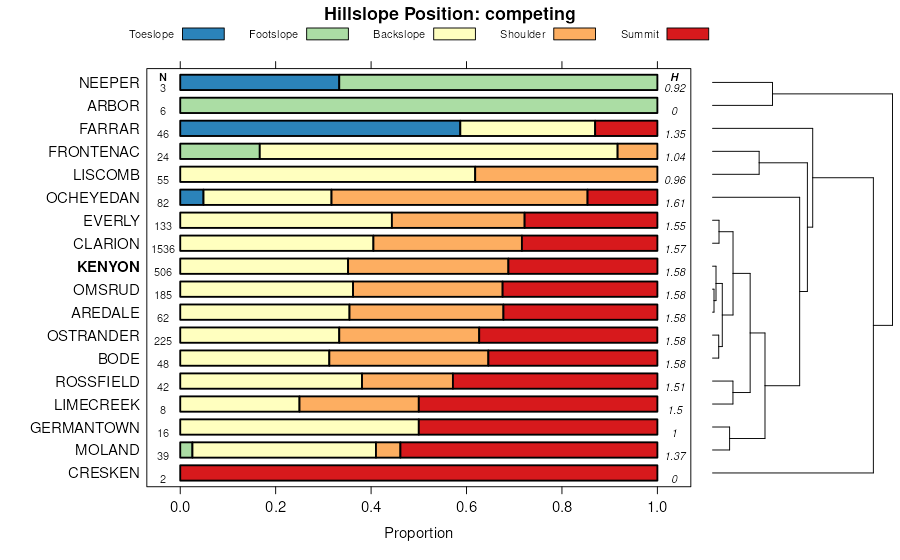
| Kenyon loam, 5 to 9 percent slopes, eroded | 83C2 | 15112 | 402924 | 2sn5z | ia011 | 1977 | 1:15840 |
Kenyon loam, 2 to 5 percent slopes | 83B | 11377 | 402922 | 2r18q | ia011 | 1977 | 1:15840 |
Kenyon loam, 5 to 9 percent slopes | 83C | 9167 | 402923 | 2sn5y | ia011 | 1977 | 1:15840 |
Kenyon loam, 9 to 14 percent slopes, eroded | 83D2 | 1413 | 402926 | 2sn60 | ia011 | 1977 | 1:15840 |
Kenyon loam, 9 to 14 percent slopes | 83D | 380 | 402925 | 2sn61 | ia011 | 1977 | 1:15840 |
Kenyon loam, 2 to 5 percent slopes | 83B | 29330 | 413300 | 2r18q | ia013 | 2001 | 1:12000 |
Kenyon-Urban land complex, 2 to 5 percent slopes | 4083B | 4029 | 413295 | 2sn64 | ia013 | 2001 | 1:12000 |
Kenyon loam, 5 to 9 percent slopes, eroded | 83C2 | 3796 | 413203 | 2sn5z | ia013 | 2001 | 1:12000 |
Kenyon loam, 5 to 9 percent slopes | 83C | 2857 | 413294 | 2sn5y | ia013 | 2001 | 1:12000 |
Kenyon-Urban land complex, 5 to 9 percent slopes | 4083C | 2623 | 413296 | 2sn65 | ia013 | 2001 | 1:12000 |
Kenyon loam, 9 to 14 percent slopes, eroded | 83D2 | 162 | 413202 | 2sn60 | ia013 | 2001 | 1:12000 |
Kenyon-Urban land complex, 9 to 14 percent slopes | 4083D | 29 | 413293 | fw21 | ia013 | 2001 | 1:12000 |
Kenyon loam, 2 to 5 percent slopes | 83B | 14462 | 1585968 | 2r18q | ia017 | 2008 | 1:12000 |
Kenyon loam, 5 to 9 percent slopes | 83C | 4935 | 1585969 | 2sn5y | ia017 | 2008 | 1:12000 |
Kenyon loam, 2 to 5 percent slopes | 83B | 64444 | 403266 | 2r18q | ia019 | 1978 | 1:15840 |
Kenyon loam, 5 to 9 percent slopes, eroded | 83C2 | 2299 | 403268 | 2sn5z | ia019 | 1978 | 1:15840 |
Kenyon loam, 5 to 9 percent slopes | 83C | 429 | 403267 | 2sn5y | ia019 | 1978 | 1:15840 |
Kenyon loam, 2 to 5 percent slopes | 83B | 31185 | 403442 | 2r18q | ia023 | 1978 | 1:15840 |
Kenyon loam, 5 to 9 percent slopes, eroded | 83C2 | 13241 | 403444 | 2sn5z | ia023 | 1978 | 1:15840 |
Kenyon loam, 5 to 9 percent slopes | 83C | 1519 | 403443 | 2sn5y | ia023 | 1978 | 1:15840 |
Kenyon loam, 9 to 14 percent slopes, eroded | 83D2 | 847 | 403445 | 2sn60 | ia023 | 1978 | 1:15840 |
Kenyon loam, 2 to 5 percent slopes | 83B | 1628 | 1397138 | 2r18q | ia031 | 2008 | 1:12000 |
Kenyon loam, 5 to 9 percent slopes, eroded | 83C2 | 985 | 1397140 | 2sn5z | ia031 | 2008 | 1:12000 |
Kenyon loam, 5 to 9 percent slopes | 83C | 575 | 1397139 | 2sn5y | ia031 | 2008 | 1:12000 |
Kenyon loam, 2 to 5 percent slopes | 83B | 23771 | 403891 | 2r18q | ia033 | 1978 | 1:15840 |
Kenyon loam, 0 to 2 percent slopes | 83 | 2801 | 403888 | fk8n | ia033 | 1978 | 1:15840 |
Kenyon loam, 5 to 9 percent slopes, eroded | 83C2 | 401 | 403892 | 2sn5z | ia033 | 1978 | 1:15840 |
Kenyon loam, 2 to 5 percent slopes | 83B | 21533 | 404088 | 2r18q | ia037 | 1989 | 1:15840 |
Kenyon loam, 5 to 9 percent slopes, eroded | 83C2 | 4873 | 404091 | 2sn5z | ia037 | 1989 | 1:15840 |
Kenyon loam, 5 to 9 percent slopes | 83C | 3303 | 404090 | 2sn5y | ia037 | 1989 | 1:15840 |
Kenyon loam, 2 to 5 percent slopes | 83B | 3337 | 404315 | 2r18q | ia043 | 1979 | 1:15840 |
Kenyon loam, 2 to 5 percent slopes | 83B | 2311 | 404463 | 2r18q | ia045 | 1978 | 1:15840 |
Kenyon loam, 5 to 9 percent slopes | 83C | 890 | 404464 | 2sn5y | ia045 | 1978 | 1:15840 |
Kenyon loam, 5 to 9 percent slopes, eroded | 83C2 | 636 | 404465 | 2sn5z | ia045 | 1978 | 1:15840 |
Kenyon loam, 2 to 5 percent slopes | 83B | 50532 | 405091 | 2r18q | ia055 | 1984 | 1:15840 |
Kenyon loam, 5 to 9 percent slopes | 83C | 1001 | 405092 | 2sn5y | ia055 | 1984 | 1:15840 |
Kenyon loam, 5 to 9 percent slopes, eroded | 83C2 | 443 | 405093 | 2sn5z | ia055 | 1984 | 1:15840 |
Kenyon loam, 2 to 5 percent slopes | 83B | 2281 | 405481 | 2r18q | ia061 | 1983 | 1:15840 |
Kenyon loam, 5 to 9 percent slopes | 83C | 682 | 405482 | 2sn5y | ia061 | 1983 | 1:15840 |
Kenyon loam, 2 to 5 percent slopes | 83B | 61595 | 405824 | 2r18q | ia065 | 1975 | 1:15840 |
Kenyon loam, 5 to 9 percent slopes | 83C | 3584 | 405825 | 2sn5y | ia065 | 1975 | 1:15840 |
Kenyon loam, 5 to 9 percent slopes, eroded | 83C2 | 1621 | 405826 | 2sn5z | ia065 | 1975 | 1:15840 |
Kenyon loam, 2 to 5 percent slopes | 83B | 17607 | 406045 | 2r18q | ia067 | 1989 | 1:15840 |
Kenyon loam, 5 to 9 percent slopes, eroded | 83C2 | 1063 | 406047 | 2sn5z | ia067 | 1989 | 1:15840 |
Kenyon loam, 0 to 2 percent slopes | 83 | 933 | 406044 | fmj6 | ia067 | 1989 | 1:15840 |
Kenyon loam, 5 to 9 percent slopes | 83C | 714 | 406046 | 2sn5y | ia067 | 1989 | 1:15840 |
Kenyon loam, 2 to 5 percent slopes | 83B | 2272 | 404959 | 2r18q | ia069 | 1977 | 1:15840 |
Kenyon loam, 5 to 9 percent slopes, eroded | 83C2 | 1869 | 404960 | 2sn5z | ia069 | 1977 | 1:15840 |
Kenyon loam, 9 to 14 percent slopes | 83D | 300 | 404961 | 2sn61 | ia069 | 1977 | 1:15840 |
Kenyon loam, 14 to 24 percent slopes | 83F | 148 | 404962 | fld9 | ia069 | 1977 | 1:15840 |
Kenyon loam, 2 to 5 percent slopes | 83B | 19219 | 406320 | 2r18q | ia075 | 1973 | 1:15840 |
Kenyon loam, 5 to 9 percent slopes, eroded | 83C2 | 1987 | 406322 | 2sn5z | ia075 | 1973 | 1:15840 |
Kenyon loam, 9 to 14 percent slopes, eroded | 83D2 | 869 | 406323 | 2sn60 | ia075 | 1973 | 1:15840 |
Kenyon loam, 5 to 9 percent slopes | 83C | 684 | 406321 | 2sn5y | ia075 | 1973 | 1:15840 |
Kenyon loam, 9 to 18 percent slopes, moderately eroded | 83E2 | 492 | 406704 | fn6h | ia083 | 1982 | 1:15840 |
Kenyon loam, 5 to 9 percent slopes, eroded | 83C2 | 320 | 406703 | 2sn5z | ia083 | 1982 | 1:15840 |
Kenyon loam, 2 to 5 percent slopes | 83B | 18289 | 407000 | 2r18q | ia089 | 1969 | 1:15840 |
Kenyon loam, 5 to 9 percent slopes | 83C | 488 | 407001 | 2sn5y | ia089 | 1969 | 1:15840 |
Kenyon loam, 5 to 9 percent slopes, eroded | 83C2 | 293 | 407002 | 2sn5z | ia089 | 1969 | 1:15840 |
Kenyon loam, 5 to 9 percent slopes | 83C | 644 | 768217 | 2sn5y | ia095 | 2005 | 1:12000 |
Kenyon loam, 5 to 9 percent slopes, eroded | 83C2 | 630 | 757930 | 2sn5z | ia095 | 2005 | 1:12000 |
Kenyon loam, 2 to 5 percent slopes | 83B | 288 | 757929 | 2r18q | ia095 | 2005 | 1:12000 |
Kenyon loam, 9 to 14 percent slopes, eroded | 83D2 | 51 | 1144424 | 2sn60 | ia095 | 2005 | 1:12000 |
Kenyon loam, 2 to 5 percent slopes | 83B | 3067 | 408062 | 2r18q | ia103 | 1979 | 1:15840 |
Kenyon loam, 5 to 9 percent slopes, eroded | 83C2 | 1843 | 408063 | 2sn5z | ia103 | 1979 | 1:15840 |
Kenyon loam, 2 to 5 percent slopes | 83B | 4411 | 408214 | 2r18q | ia105 | 1988 | 1:15840 |
Kenyon loam, 5 to 9 percent slopes | 83C | 614 | 408215 | 2sn5y | ia105 | 1988 | 1:15840 |
Kenyon loam, 5 to 9 percent slopes, eroded | 83C2 | 369 | 408216 | 2sn5z | ia105 | 1988 | 1:15840 |
Kenyon loam, 2 to 5 percent slopes | 83B | 26761 | 408684 | 2r18q | ia113 | 1970 | 1:15840 |
Kenyon loam, 5 to 9 percent slopes | 83C | 12174 | 408685 | 2sn5y | ia113 | 1970 | 1:15840 |
Kenyon loam, 5 to 9 percent slopes, eroded | 83C2 | 7925 | 408686 | 2sn5z | ia113 | 1970 | 1:15840 |
Kenyon-Urban land complex, 2 to 5 percent slopes | 4083B | 1740 | 2606447 | 2sn64 | ia113 | 1970 | 1:15840 |
Kenyon-Urban land complex, 5 to 9 percent slopes | 4083C | 1723 | 2606448 | 2sn65 | ia113 | 1970 | 1:15840 |
Kenyon loam, 9 to 14 percent slopes, eroded | 83D2 | 638 | 408687 | 2sn60 | ia113 | 1970 | 1:15840 |
Kenyon loam, 2 to 5 percent slopes | 83B | 5068 | 409722 | 2r18q | ia131 | 1971 | 1:15840 |
Kenyon loam, 0 to 2 percent slopes | 83 | 1742 | 409721 | frbt | ia131 | 1971 | 1:15840 |
Kenyon loam, 5 to 9 percent slopes | 83C | 565 | 409723 | 2sn5y | ia131 | 1971 | 1:15840 |
Kenyon loam, 5 to 9 percent slopes, eroded | 83C2 | 297 | 409724 | 2sn5z | ia131 | 1971 | 1:15840 |
Kenyon loam, 5 to 9 percent slopes, eroded | 83C2 | 951 | 411069 | 2sn5z | ia163 | 1989 | 1:15840 |
Kenyon loam, 9 to 14 percent slopes, severely eroded | 83D3 | 521 | 411071 | fsrc | ia163 | 1989 | 1:15840 |
Kenyon loam, 9 to 14 percent slopes, eroded | 83D2 | 345 | 411070 | 2sn60 | ia163 | 1989 | 1:15840 |
Kenyon loam, 2 to 5 percent slopes | 83B | 284 | 411068 | 2r18q | ia163 | 1989 | 1:15840 |
Kenyon loam, 5 to 9 percent slopes, eroded | 83C2 | 605 | 411564 | 2sn5z | ia171 | 1989 | 1:15840 |
Kenyon loam, 2 to 5 percent slopes | 83B | 223 | 411562 | 2r18q | ia171 | 1989 | 1:15840 |
Kenyon loam, 2 to 5 percent slopes | 83B | 2562 | 2398674 | 2r18q | ia195 | 2012 | 1:12000 |
Kenyon loam, 5 to 9 percent slopes, eroded | 83C2 | 386 | 2398675 | 2sn5z | ia195 | 2012 | 1:12000 |
Kenyon silt loam, 6 to 12 percent slopes, moderately eroded | M521C2 | 715 | 1385255 | 1hhgn | mn039 | 2005 | 1:12000 |
Kenyon silt loam, 0 to 1 percent slopes | Kd | 6354 | 2216751 | 2ddq3 | mn045 | 2008 | 1:12000 |
Kenyon silt loam, 2 to 6 percent slopes | Ke | 5205 | 2216752 | 2sn63 | mn045 | 2008 | 1:12000 |
Kenyon silt loam, 6 to 12 percent slopes, moderately eroded | M521C2 | 973 | 1670739 | 1t2jt | mn049 | 2007 | 1:12000 |
Kenyon silt loam, 2 to 6 percent slopes | 30B | 3704 | 400451 | 2sn63 | mn099 | 1986 | 1:15840 |
Kenyon loam, 2 to 5 percent slopes | 30B | 6911 | 400757 | 2r18q | mn109 | 1977 | 1:15840 |


