| Zeebar family, very stony surface-Howcan family, extremely stony surface-Kegsprings family, extremely stony surface, complex, 35 to 75 percent slopes | 43B7CY | 131276 | 3377635 | 313tr | id720 | | 1:24000 |
Ustic Argicryolls family, very stony surface-Typic Argiustolls family, extremely stony surface-Kegsprings family, extremely stony surface, 35 to 75 percent slopes | 43B7DQ | 40753 | 3458630 | 31wlq | id720 | | 1:24000 |
Langer family-Etchen family-Kegsprings family, complex, 10 to 60 percent slopes | 127CN | 1892 | 3320443 | 30mr8 | id720 | | 1:24000 |
Kegsprings family, extremely stony surface-Arrowpeak family, very stony surface, complex, 1 to 35 percent slopes | 43B7DV | 488 | 3458639 | 31wm1 | id720 | | 1:24000 |
Langer family-Etchen family-Kegsprings family, complex, 10 to 60 percent slopes | 127CN | 807 | 3312447 | 30mr8 | id752 | 1999 | 1:24000 |
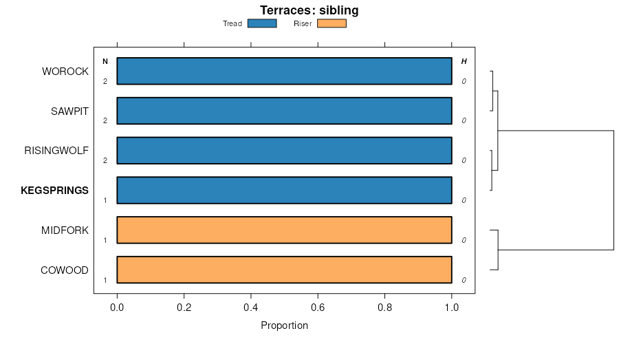
Kegsprings family, stony-Mikesell family-Risingwolf, dry complex, 15 to 35 percent slopes | 253E | 3014 | 3005104 | 2x3qv | mt600 | 1969 | 1:24000 |
Kegsprings family, very rubbly-Rubble land-Cowood family, rubbly, complex, 35 to 70 percent slopes | 5202G | 749 | 3039689 | 2v1n0 | mt602 | 1963 | 1:20000 |
Kegsprings, extremely stony-Sawpit, very stony-Drywolf, very rubbly families, complex, 20 to 60 percent slopes | 2268F | 204 | 3039657 | 2qbz5 | mt602 | 1963 | 1:20000 |
Risingwolf-Sherlock family-Kegsprings family, stony complex, 35 to 60 percent slopes | 2340F | 169 | 3384106 | 316lb | mt603 | 1989 | 1:24000 |
Kegsprings family, very stony-Worock-Risingwolf complex, 35 to 60 percent slopes | 2344F | 122 | 3384105 | 316lc | mt603 | 1989 | 1:24000 |
Kegsprings family-Risingwolf-Sherlock family complex, 0 to 15 percent slopes | 2100D | 106 | 3384193 | 316l2 | mt603 | 1989 | 1:24000 |
Kegsprings-Helmville, very bouldery complex, 25 to 60 percent slopes | 921F | 541 | 2598014 | 2ppb4 | mt605 | 2007 | 1:24000 |
Lonniebee, stony-Kegsprings-Slidemountain, extremely stony complex, 25 to 60 percent slopes | 747F | 1358 | 2512551 | 2pphz | mt612 | 2011 | 1:24000 |
Kegsprings, very stony-Lonniebee-Cowood, extremely stony complex, 25 to 50 percent slopes | 748F | 1174 | 2512552 | 2ppj0 | mt612 | 2011 | 1:24000 |
Kegsprings, extremely stony-Sawpit, very stony-Drywolf, very rubbly families, complex, 20 to 60 percent slopes | 2268F | 292 | 3039707 | 2qbz5 | mt613 | 1975 | 1:24000 |
Kegsprings-Helmville, very bouldery complex, 25 to 60 percent slopes | 921F | 602 | 2518721 | 2ppb4 | mt614 | 2012 | 1:24000 |
Lonniebee, stony-Kegsprings-Slidemountain, extremely stony complex, 25 to 60 percent slopes | 747F | 5 | 2633469 | 2pphz | mt614 | 2012 | 1:24000 |
Kegsprings family, very rubbly-Rubble land-Cowood family, rubbly, complex, 35 to 70 percent slopes | 5202G | 226 | 3044843 | 2v1n0 | mt615 | 1992 | 1:24000 |
Kegsprings, extremely stony-Sawpit, very stony-Drywolf, very rubbly families, complex, 20 to 60 percent slopes | 2268F | 115 | 3044831 | 2qbz5 | mt615 | 1992 | 1:24000 |
Kegsprings family, very stony-Worock-Risingwolf complex, 35 to 60 percent slopes | 2344F | 5657 | 3384118 | 316lc | mt619 | 1988 | 1:24000 |
Risingwolf-Sherlock family-Kegsprings family, stony complex, 35 to 60 percent slopes | 2340F | 5482 | 3384119 | 316lb | mt619 | 1988 | 1:24000 |
Mohaggin, stony,dry-Worock-Kegsprings, stony families, complex, 15 to 35 percent slopes | 410E | 136 | 3005126 | 2v5vf | mt619 | 1988 | 1:24000 |
Risingwolf, very stony, dry-Kegsprings family-Worock family, complex, 4 to 15 percent slopes | 270D | 13 | 3005125 | 2v5v0 | mt619 | 1988 | 1:24000 |
Risingwolf-Sherlock family-Kegsprings family, stony complex, 35 to 60 percent slopes | 2340F | 235 | 3384130 | 316lb | mt631 | 1988 | 1:24000 |
Kegsprings, extremely stony-Sawpit, very stony-Drywolf, very rubbly families, complex, 20 to 60 percent slopes | 2268F | 9753 | 2512886 | 2qbz5 | mt632 | | 1:24000 |
Kegsprings family, extremely stony-Sawpit family, very stony-Drywolf, very rubbly, complex, 20 to 60 percent slopes, moist | 1368F | 5612 | 2484340 | 2pd50 | mt632 | | 1:24000 |
Kegsprings, extremely stony-Sawpit, very stony-Worock, stony families, complex, 8 to 35 percent slopes | 1368E | 5078 | 2632230 | 2qbzb | mt632 | | 1:24000 |
Kegsprings family, very rubbly-Rubble land-Cowood family, rubbly, complex, 35 to 70 percent slopes | 5202G | 3544 | 2833639 | 2v1n0 | mt632 | | 1:24000 |
Worock, stony-Kegsprings, extremely stony families, complex, 2 to 15 percent slopes | 1368D | 2840 | 2484339 | 2pd4z | mt632 | | 1:24000 |
Cuberant family, very stony-Rock outcrop-Kegsprings family complex, 35 to 60 percent slopes | 2472F | 1306 | 3384158 | 316mh | mt632 | | 1:24000 |
Kegsprings family, stony-Jaegie family-Worock family complex, 35 to 60 percent slopes | 2372F | 1067 | 3384162 | 316mf | mt632 | | 1:24000 |
Kegsprings family, very stony-Worock family, stony-Cuberant family, very stony complex, 35 to 60 percent slopes | 2374F | 206 | 3384161 | 316mg | mt632 | | 1:24000 |
Risingwolf-Sherlock family-Kegsprings family, stony complex, 35 to 60 percent slopes | 2340F | 190 | 3384144 | 316lb | mt632 | | 1:24000 |
Kegsprings family, very stony-Worock-Risingwolf complex, 35 to 60 percent slopes | 2344F | 89 | 3384152 | 316lc | mt632 | | 1:24000 |
Risingwolf-Sherlock family-Kegsprings family, stony complex, 35 to 60 percent slopes | 2340F | 136524 | 3384038 | 316lb | mt633 | | 1:24000 |
Kegsprings family, very stony-Worock-Risingwolf complex, 35 to 60 percent slopes | 2344F | 89426 | 3384039 | 316lc | mt633 | | 1:24000 |
Kegsprings family-Risingwolf-Sherlock family complex, 0 to 15 percent slopes | 2100D | 20028 | 3384030 | 316l2 | mt633 | | 1:24000 |
Kegsprings family, very stony-Worock family, stony-Cuberant family, very stony complex, 35 to 60 percent slopes | 2374F | 9498 | 3384068 | 316mg | mt633 | | 1:24000 |
Kegsprings family, stony-Jaegie family-Worock family complex, 35 to 60 percent slopes | 2372F | 6759 | 3384067 | 316mf | mt633 | | 1:24000 |
Cuberant family, very stony-Rock outcrop-Kegsprings family complex, 35 to 60 percent slopes | 2472F | 6035 | 3384069 | 316mh | mt633 | | 1:24000 |
Broad Canyon family, stony-Kegsprings family-Risingwolf complex, 2 to 15 percent slopes | 2004D | 1153 | 3384051 | 316ly | mt633 | | 1:24000 |
Parkcity-Bigcoulee-Kegsprings families, complex, 0 to 15 percent slopes | 2130D | 540 | 3384033 | 316l5 | mt633 | | 1:24000 |
Risingwolf-Sherlock family-Kegsprings family, stony complex, 35 to 60 percent slopes | 2340F | 2117 | 3384176 | 316lb | mt638 | 1985 | 1:24000 |
Kegsprings family, very stony-Worock-Risingwolf complex, 35 to 60 percent slopes | 2344F | 1804 | 3384175 | 316lc | mt638 | 1985 | 1:24000 |
Broad Canyon family, stony-Kegsprings family-Risingwolf complex, 2 to 15 percent slopes | 2004D | 349 | 3384181 | 316ly | mt638 | 1985 | 1:24000 |
Risingwolf, very stony, dry-Kegsprings family-Sherlock family, complex, 8 to 35 percent slopes | 261E | 36787 | 2848273 | 2v5v5 | mt663 | 2017 | 1:24000 |
Risingwolf, very stony, dry-Kegsprings family-Worock family, complex, 4 to 15 percent slopes | 270D | 25119 | 2848277 | 2v5v0 | mt663 | 2017 | 1:24000 |
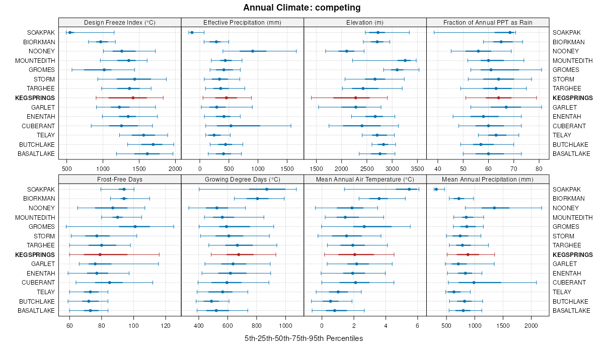
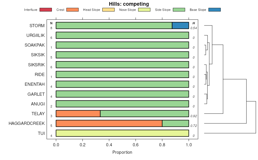
Garlet-Kegsprings-Muddycreek families, complex, 35 to 60 slopes | 325F | 24796 | 2851842 | 2v7zv | mt663 | 2017 | 1:24000 |
Mohaggin, stony,dry-Worock-Kegsprings, stony families, complex, 15 to 35 percent slopes | 410E | 23724 | 2848282 | 2v5vf | mt663 | 2017 | 1:24000 |
Kegsprings family, stony-Mikesell family-Risingwolf, dry complex, 15 to 35 percent slopes | 253E | 11590 | 2848266 | 2x3qv | mt663 | 2017 | 1:24000 |
Kegsprings family, stony-Agneston family complex 10 to 25 percent slopes | 19 | 10468 | 707856 | rrl2 | wy632 | | 1:24000 |
Agneston-Kegsprings family, complex, 0 to 10 percent slopes | 11 | 9553 | 707836 | rrkf | wy632 | | 1:24000 |
Kegsprings family, very stony loam, 25 to 40 percent slopes, stony | 17 | 6145 | 707854 | rrl0 | wy632 | | 1:24000 |
Kegsprings family, stony-Rock outcrop complex, 40 to 65 percent slopes | 20 | 3762 | 707859 | rrl5 | wy632 | | 1:24000 |
Kegsprings family, very stony loam, 40 to 65 percent slopes, stony | 18 | 1704 | 707855 | rrl1 | wy632 | | 1:24000 |
Mountain Front Sideslopes, Subalpine Fir-Aspen Complex | 4641 | 3706 | 2554700 | 532p | wy635 | | 1:24000 |
Southeast Mountains Sideslopes, Subalpine Fir-Aspen Complex | 7642 | 1553 | 2925082 | 532y | wy635 | | 1:24000 |
Mountain Front Till-Mantled Sideslopes (North), Subalpine Fir Complex | 4642 | 228 | 2554701 | 531k | wy635 | | 1:24000 |
Sedimentary Conglomerate Sideslopes (North), Subalpine Fir Complex | 3642 | 26 | 2554696 | 530z | wy635 | | 1:24000 |
Limber-Watsondraw-Kegsprings families, complex, 10 to 40 percent slopes | 391 | 40826 | 620896 | nv2x | wy661 | 1985 | 1:24000 |
Kegsprings-Kaina-Limber families, complex, 12 to 45 percent slopes | 455 | 22007 | 620920 | nv3p | wy661 | 1985 | 1:24000 |
Coldfeet-Kegsprings-Beaveridge families, complex, 2 to 20 percent slopes | 253 | 21554 | 620412 | ntl9 | wy661 | 1985 | 1:24000 |
Limber-Grade-Kegsprings families, complex, 5 to 30 percent slopes | 361 | 16448 | 157973 | 59cx | wy661 | 1985 | 1:24000 |
Kegsprings-Kaina families, association, 12 to 70 percent slopes | 488 | 12924 | 157974 | 59cy | wy661 | 1985 | 1:24000 |
Mulgon-Kegsprings-Jumpstart families, complex, 0 to 30 percent slopes | 155 | 12804 | 2633481 | 2r7fx | wy661 | 1985 | 1:24000 |
Kegsprings-Coldfeet-Grade families, complex, 10 to 35 percent slopes | 372 | 12575 | 620778 | ntz3 | wy661 | 1985 | 1:24000 |
Kegsprings very gravelly sandy loam family, 10 to 40 percent slopes | 338 | 11076 | 620413 | ntlb | wy661 | 1985 | 1:24000 |
Kegsprings-Mine families, complex, 5 to 20 percent slopes | 233 | 7937 | 620411 | ntl8 | wy661 | 1985 | 1:24000 |
Badgerton-Coutis-Kegsprings families, association, 5 to 20 percent slopes | 123 | 7499 | 620392 | ntkn | wy661 | 1985 | 1:24000 |
Stringam-Kegsprings families, complex, 5 to 30 percent slopes | 463 | 5870 | 620927 | nv3x | wy661 | 1985 | 1:24000 |
Kegsprings-Fingerrock-Ledgefork families, complex, 0 to 10 percent slopes, very rarely flooded | 110 | 4767 | 620369 | ntjx | wy661 | 1985 | 1:24000 |
Kegsprings-Broad Canyon-Limber families, association, 10 to 35 percent slopes | 451 | 4005 | 620918 | nv3m | wy661 | 1985 | 1:24000 |
Southeast Mountains Sideslopes, Subalpine Fir-Aspen Complex | 7642 | 9110 | 151929 | 532y | wy662 | 1998 | 1:24000 |
Mountain Front Colluvial Sideslopes (North), Subalpine Fir Complex | 4643 | 9052 | 151887 | 531l | wy662 | 1998 | 1:24000 |
Mountain Front Moraines, Subalpine Fir Complex | 4341 | 7931 | 151918 | 532l | wy662 | 1998 | 1:24000 |
Sedimentary Colluvial Sideslopes, Subalpine Fir Complex | 3646 | 7775 | 151871 | 5312 | wy662 | 1998 | 1:24000 |
Sedimentary Conglomerate Sideslopes (North), Subalpine Fir Complex | 3642 | 4697 | 151868 | 530z | wy662 | 1998 | 1:24000 |
Sedimentary Chugwater Sideslopes (North), Subalpine Fir Complex | 3643 | 4507 | 151869 | 5310 | wy662 | 1998 | 1:24000 |
Mountain Front Till-Mantled Sideslopes (South), Subalpine Fir Complex | 4645 | 4428 | 151932 | 5331 | wy662 | 1998 | 1:24000 |
Mountain Front Till-Mantled Sideslopes (North), Subalpine Fir Complex | 4642 | 4122 | 151886 | 531k | wy662 | 1998 | 1:24000 |
Mountain Front Colluvial Sideslopes (South), Subalpine Fir Complex | 4644 | 3912 | 151933 | 5332 | wy662 | 1998 | 1:24000 |
Mountain Front Sideslopes, Subalpine Fir-Aspen Complex | 4641 | 2911 | 151921 | 532p | wy662 | 1998 | 1:24000 |
Sedimentary Sideslopes, Tall Forb-Subalpine Fir Complex | 3657 | 2451 | 151878 | 5319 | wy662 | 1998 | 1:24000 |
Foothill Sideslopes, Big Sagebrush-Aspen-Subalpine fir Complex | 6621 | 1383 | 151898 | 531y | wy662 | 1998 | 1:24000 |
Mulgon-Kegsprings-Jumpstart families, complex, 0 to 30 percent slopes | 155 | 61 | 2633476 | 2r7fx | wy662 | 1998 | 1:24000 |
Kegsprings family-Rock outcrop-Matcher family, complex | 1583 | 60507 | 3056502 | 2xtrp | wy665 | 1996 | 1:62500 |
Kegsprings-Targhee families-Rock outcrop, complex | 1358 | 49396 | 3056505 | 2xtrk | wy665 | 1996 | 1:62500 |
Kegsprings family-Rock outcrop-Targhee family, complex | 1537 | 38668 | 3056503 | 2xtrm | wy665 | 1996 | 1:62500 |
Hobacker-Kegsprings families-Typic Cryaquolls, complex | 2167 | 33902 | 3056523 | 2xts3 | wy665 | 1996 | 1:62500 |
Kegsprings-Agneston families-Rock outcrop, complex | 1759 | 29110 | 3056514 | 2xtrv | wy665 | 1996 | 1:62500 |
Jaegie-Kegsprings families-Rock outcrop, complex | 1752 | 25459 | 3056512 | 2xtrt | wy665 | 1996 | 1:62500 |
Kegsprings family-Histic Cryaquepts-Rock outcrop, complex | 1562 | 18016 | 3056501 | 2xtrn | wy665 | 1996 | 1:62500 |
Midfork-Kegsprings families-Rock outcrop, complex | 2154 | 15971 | 3056509 | 2xts1 | wy665 | 1996 | 1:62500 |
Kegsprings-Jaegie families-Typic Cryaquepts, complex | 1762 | 14597 | 3056513 | 2xtrw | wy665 | 1996 | 1:62500 |
Kegsprings-Agneston-Quietus families, complex | 1795 | 14511 | 3056515 | 2xtrx | wy665 | 1996 | 1:62500 |
Shook, Sawpit and Kegsprings families, soils | 2216 | 13108 | 3056524 | 2xts7 | wy665 | 1996 | 1:62500 |
Midfork-Kegsprings-Doct families, complex | 2126 | 11537 | 3056508 | 2xts0 | wy665 | 1996 | 1:62500 |
Hobacker-Elkpeak-Kegsprings families, complex | 2915 | 10252 | 3056532 | 2xtsp | wy665 | 1996 | 1:62500 |
Kegsprings family-Rock outcrop-Sig family, complex | 1532 | 5100 | 3056504 | 2xtrl | wy665 | 1996 | 1:62500 |


