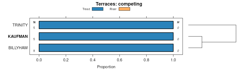
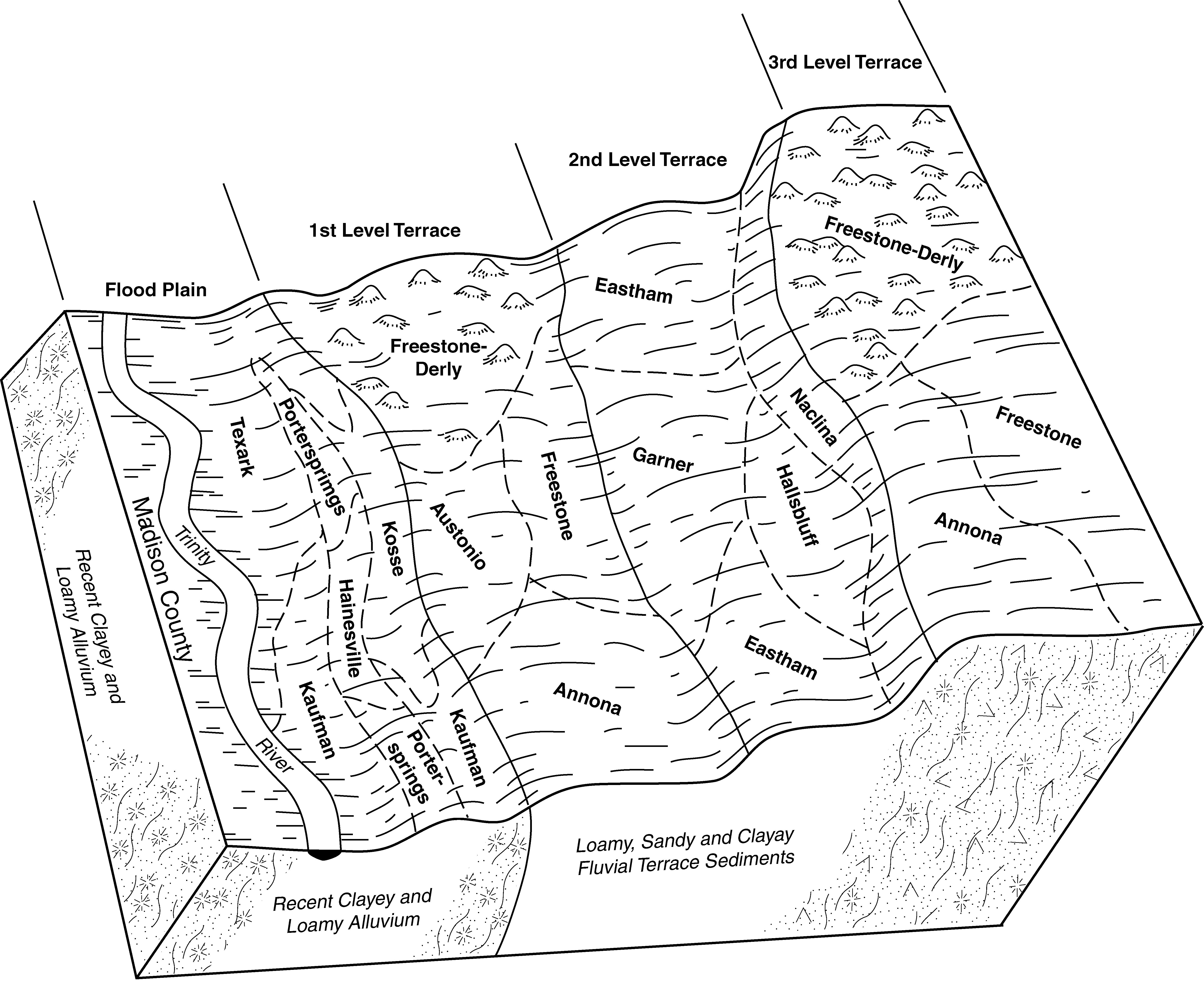
Official Series Description


Lab Data Summary

Aggregate lab data for the KAUFMAN soil series. This aggregation is based on all pedons with a current taxon name of KAUFMAN, and applied along 1-cm thick depth slices. Solid lines are the slice-wise median, bounded on either side by the interval defined by the slice-wise 5th and 95th percentiles. The median is the value that splits the data in half. Five percent of the data are less than the 5th percentile, and five percent of the data are greater than the 95th percentile. Values along the right hand side y-axis describe the proportion of pedon data that contribute to aggregate values at this depth. For example, a value of "90%" at 25cm means that 90% of the pedons correlated to KAUFMAN were used in the calculation. Source: KSSL snapshot . Methods used to assemble the KSSL snapshot used by SoilWeb / SDE

Click the image to view it full size.

Pedons used in the lab summary:

MLRALab IDPedon IDTaxonnameCINSSL / NASIS ReportsLink To SoilWeb GMap
87AS85TX313004S85TX313004Kaufman5Primary | Supplementary | Taxonomy | Pedon | Water Retention | Correlation | Andic Soil Properties31.0457444,-95.6440611

Water Balance

Monthly water balance estimated using a leaky-bucket style model for the KAUFMAN soil series. Monthly precipitation (PPT) and potential evapotranspiration (PET) have been estimated from the 50th percentile of gridded values (PRISM 1981-2010) overlapping with the extent of SSURGO map units containing each series as a major component. Monthly PET values were estimated using the method of Thornthwaite (1948). These (and other) climatic parameters are calculated with each SSURGO refresh and provided by the fetchOSD function of the soilDB package. Representative water storage values (“AWC” in the figures) were derived from SSURGO by taking the 50th percentile of profile-total water storage (sum[awc_r * horizon thickness]) for each soil series. Note that this representation of “water storage” is based on the average ability of most plants to extract soil water between 15 bar (“permanent wilting point”) and 1/3 bar (“field capacity”) matric potential. Soil moisture state can be roughly interpreted as “dry” when storage is depleted, “moist” when storage is between 0mm and AWC, and “wet” when there is a surplus. Clearly there are a lot of assumptions baked into this kind of monthly water balance. This is still a work in progress.

Click the image to view it full size.


Click the image to view it full size.

Sibling Summary

Siblings are those soil series that occur together in map units, in this case with the KAUFMAN series. Sketches are arranged according to their subgroup-level taxonomic structure. Source: SSURGO snapshot , parsed OSD records and snapshot of SC database .

Click the image to view it full size.

Select annual climate data summaries for the KAUFMAN series and siblings. Series are sorted according to hierarchical clustering of median values. Source: SSURGO map unit geometry and 1981-2010, 800m PRISM data .

Click the image to view it full size.

Geomorphic description summaries for the KAUFMAN series and siblings. Series are sorted according to hierarchical clustering of proportions and relative hydrologic position within an idealized landform (e.g. top to bottom). Most soil series (SSURGO components) are associated with a hillslope position and one or more landform-specific positions: hills, mountain slopes, terraces, and/or flats. Proportions can be interpreted as an aggregate representation of geomorphic membership. The values printed to the left (number of component records) and right (Shannon entropy) of stacked bars can be used to judge the reliability of trends. Small Shannon entropy values suggest relatively consistent geomorphic association, while larger values suggest lack thereof. Source: SSURGO component records .

Click the image to view it full size.

There are insufficient data to create the 3D hills figure.

There are insufficient data to create the 3D mountains figure.

Click the image to view it full size.

Click the image to view it full size.

Competing Series

Soil series competing with KAUFMAN share the same family level classification in Soil Taxonomy. Source: parsed OSD records and snapshot of the SC database .

Click the image to view it full size.

Select annual climate data summaries for the KAUFMAN series and competing. Series are sorted according to hierarchical clustering of median values. Source: SSURGO map unit geometry and 1981-2010, 800m PRISM data .

Click the image to view it full size.

Geomorphic description summaries for the KAUFMAN series and competing. Series are sorted according to hierarchical clustering of proportions and relative hydrologic position within an idealized landform (e.g. top to bottom). Proportions can be interpreted as an aggregate representation of geomorphic membership. Most soil series (SSURGO components) are associated with a hillslope position and one or more landform-specific positions: hills, mountain slopes, terraces, and/or flats. The values printed to the left (number of component records) and right (Shannon entropy) of stacked bars can be used to judge the reliability of trends. Shannon entropy values close to 0 represent soil series with relatively consistent geomorphic association, while values close to 1 suggest lack thereof. Source: SSURGO component records .

Click the image to view it full size.

There are insufficient data to create the 3D hills figure.

There are insufficient data to create the 3D mountains figure.

Click the image to view it full size.

Click the image to view it full size.

Soil series sharing subgroup-level classification with KAUFMAN, arranged according to family differentiae. Hovering over a series name will print full classification and a small sketch from the OSD. Source: snapshot of SC database .

Block Diagrams

Click a link below to display the diagram. Note that these diagrams may be from multiple survey areas.

  1. TX-2010-11-03-39 | Houston County - 2002

    Typical pattern of soils and parent material on terraces and along the flood plains of the Trinity River (Soil Survey of Houston County, Texas; 2002).

  2. TX-2012-03-21-33 | Leon County - July 1989

    The Gladewater, Kaufman, and Nahatche soils are dominant on the terraces and flood plains of the Trinity River system (Soil Survey of Leon County, TX; 1989).

Map Units

Map units containing KAUFMAN as a major component. Limited to 250 records.

Map Unit Name Symbol Map Unit Area (ac) Map Unit Key National Map Unit Symbol Soil Survey Area Publication Date Map Scale
Kaufman clay loamKa2478330920c3bval10119581:20000
Kaufman clayKa1554565693lzn5ar06119701:24000
Kaufman clay, 0 to 1 percent slopes, occasionally flooded5012379571366m5k5ok00519771:24000
Kaufman-Gowton complex, 0 to 1 percent slopes, frequently flooded513794571367m5k6ok00519771:24000
Kaufman clay, 0 to 1 percent slopes, occasionally flooded46102923818282ypvgok01319741:24000
Kaufman clay, 0 to 1 percent slopes, frequently flooded4733403818292wg9dok01319741:24000
Kaufman clay, 0 to 1 percent slopes, frequently flooded318206571222m5djok02319771:24000
Kaufman clay, 0 to 1 percent slopes, occasionally flooded301898571221m5dhok02319771:24000
Kaufman silty clay, 0 to 1 percent slopes, occasionally floodedKa4593571602m5ssok02919691:24000
Kaufman clay, 0 to 1 percent slopes, occasionally flooded301820383294dvvbok06919761:24000
Kaufman clay, 0 to 1 percent slopes, occasionally floodedKa3736571158m5bgok08919701:24000
Kaufman clay, 0 to 1 percent slopes, frequently floodedKc1524571159m5bhok08919701:24000
Kaufman clay, 0 to 1 percent slopes, frequently floodedKc260025751442wg9dtx00119701:20000
Kaufman clay, rarely floodedKa7118575143m9h0tx00119701:20000
Kaufman clay, 0 to 1 percent slopes, frequently flooded, southernKa52453632032ypvhtx04119931:20000
Kaufman clay, 0 to 1 percent slopes, frequently flooded, southernKa76333634512ypvhtx05119941:24000
Kaufman clay, 0 to 1 percent slopes, frequently flooded4923073650012wg9dtx12119751:24000
Kaufman clay, 0 to 1 percent slopes, frequently floodedKd206283753952wg9dtx16119861:24000
Kaufman clay loam, 0 to 1 percent slopes, overwash, occasionally floodedKa24563753932ypvjtx16119861:24000
Kaufman clay, 0 to 1 percent slopes, occasionally floodedKc16123753942ypvgtx16119861:24000
Kaufman clay, loamy substratum, frequently floodedKf914375396dlmktx16119861:24000
Kaufman clay, rarely flooded197059367608dbjbtx21319781:20000
Kaufman clay, 0 to 1 percent slopes, frequently flooded2021943676102wg9dtx21319781:20000
Kaufman clay, 0 to 1 percent slopes, occasionally floodedKa100065755162ypvgtx22519941:24000
Kaufman clay, 0 to 1 percent slopes, frequently floodedKb26695755172wg9dtx22519941:24000
Kaufman clay, 0 to 1 percent slopes, frequently flooded19445743678802wg9dtx23119781:24000
Kaufman clay, 0 to 1 percent slopes, occasionally flooded1825513678792ypvgtx23119781:24000
Kaufman clay, 0 to 1 percent slopes, frequently floodedKf94743692082wg9dtx28919851:24000
Kaufman clay, 0 to 1 percent slopes, occasionally floodedKa29033692072ypvgtx28919851:24000
Kaufman and Gladewater soils, 0 to 1 percent slopes, frequently floodedKg17853692092ypvftx28919851:24000
Kaufman clay, 0 to 1 percent slopes, frequently floodedKd104293694032wg9dtx29319911:24000
Kaufman clay, 0 to 1 percent slopes, occasionally floodedKc4953694022ypvgtx29319911:24000
Kaufman clay, 0 to 1 percent slopes, occasionally floodedKa45223702962ypvgtx31319891:24000
Kaufman clay, 0 to 1 percent slopes, frequently floodedKf22583702972wg9dtx31319891:24000
Kaufman clay, 0 to 1 percent slopes, frequently flooded, southernKc30515755912ypvhtx33919671:20000
Kaufman clay, 0 to 1 percent slopes, occasionally floodedKa167193709492ypvgtx34919681:24000
Kaufman clay, 0 to 1 percent slopes, frequently floodedKc52203709502wg9dtx34919681:24000
Kaufman clay, 0 to 1 percent slopes, frequently floodedKb318043714452wg9dtx38719721:24000
Kaufman clay, 0 to 1 percent slopes, occasionally floodedKa58953714442ypvgtx38719721:24000
Kaufman clay, 0 to 1 percent slopes, occasionally flooded28142095759582ypvgtx47119751:20000
Kaufman-Gowker complex, 0 to 1 percent slopes, frequently flooded2949585759592y0vctx47119751:20000
Kaufman clay, 0 to 1 percent slopes, frequently flooded, southern3742103731652ypvhtx47719791:24000
Kaufman clay, 0 to 1 percent slopes, frequently flooded, southernKf28063736062ypvhtx49319721:24000
Kaufman clay, 0 to 1 percent slopes, frequently floodedKa167015761072wg9dtx60319841:24000
Kaufman clay, 0 to 1 percent slopes, frequently floodedKa98463743952wg9dtx61019731:20000
Kaufman clay, 0 to 1 percent slopes, frequently floodedKb152733744812wg9dtx61219731:20000
Kaufman clay, 0 to 1 percent slopes, occasionally floodedKa40523744802ypvgtx61219731:20000
Kaufman clay, 0 to 1 percent slopes, frequently flooded30153453933602wg9dtx61419751:20000
Kaufman clay, 0 to 1 percent slopes, occasionally flooded2980893933592ypvgtx61419751:20000

Map of Series Extent

Approximate geographic distribution of the KAUFMAN soil series. To learn more about how this distribution was mapped, or to compare this soil series extent to others, use the Series Extent Explorer (SEE) application. Source: generalization of SSURGO geometry .