| Judson silty clay loam, dissected till plain, 2 to 5 percent slopes | 8B | 955 | 402215 | 2sy6z | ia001 | 1976 | 1:15840 |
Judson silty clay loam, dissected till plain, 5 to 9 percent slopes | 8C | 436 | 402216 | 2sy72 | ia001 | 1976 | 1:15840 |
Judson silty clay loam, dissected till plain, 2 to 5 percent slopes | 8B | 2747 | 1404873 | 2sy6z | ia003 | 2008 | 1:12000 |
Judson-Colo-Ackmore complex, 2 to 5 percent slopes | 11B | 52122 | 402748 | 30kfw | ia009 | 1982 | 1:15840 |
Judson silty clay loam, deep loess, 2 to 5 percent slopes | 8B | 5274 | 402786 | 2sy6y | ia009 | 1982 | 1:15840 |
Judson silty clay loam, deep loess, 5 to 9 percent slopes | 8C | 1254 | 402787 | 2sy71 | ia009 | 1982 | 1:15840 |
Gullied land-Judson complex, 5 to 40 percent slopes | 980G | 812 | 402793 | 2sy74 | ia009 | 1982 | 1:15840 |
Judson silty clay loam, 2 to 5 percent slopes | 8B | 22 | 2474791 | 31170 | ia023 | 1978 | 1:15840 |
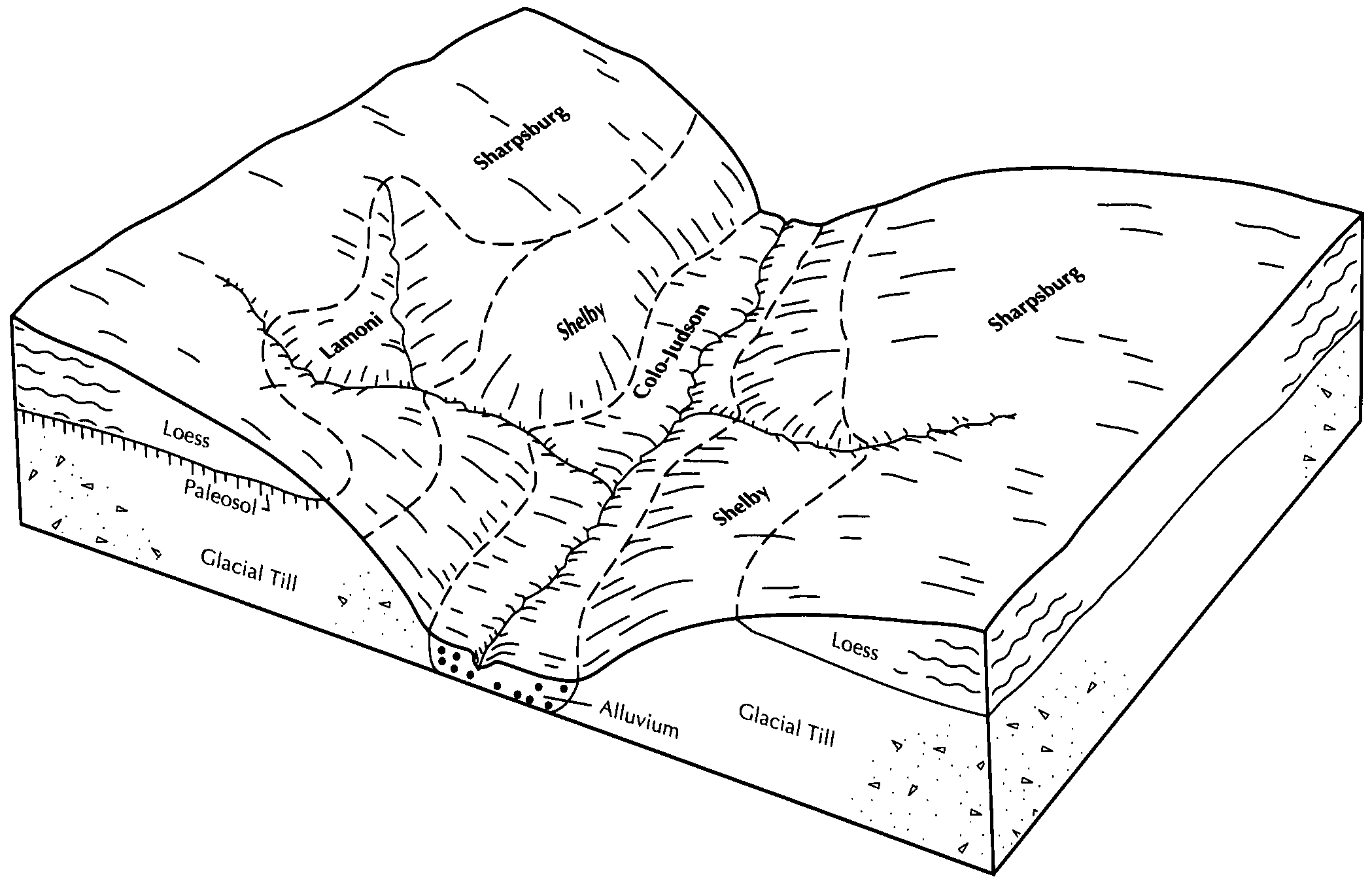
Colo-Judson silty clay loams, 0 to 5 percent slopes, occasionally flooded | 11B | 40019 | 403504 | 2sy7j | ia027 | 1979 | 1:15840 |
Ackmore-Judson complex, 1 to 5 percent slopes | 5B | 927 | 403553 | 2zsp7 | ia027 | 1979 | 1:15840 |
Judson silty clay loam, deep loess, 2 to 5 percent slopes | 8B | 874 | 403568 | 2sy6y | ia027 | 1979 | 1:15840 |
Judson silty clay loam, deep loess, 5 to 9 percent slopes | 8C | 582 | 403569 | 2sy71 | ia027 | 1979 | 1:15840 |
Judson-Ackmore-Colo, overwash complex, 1 to 5 percent slopes | 431B | 35781 | 2423007 | 2y6b2 | ia029 | 2010 | 1:12000 |
Judson silty clay loam, deep loess, 2 to 5 percent slopes | Z8B | 11517 | 1867979 | 2sy6y | ia029 | 2010 | 1:12000 |
Judson silty clay loam, dissected till plain, 2 to 5 percent slopes | Y8B | 2908 | 2486179 | 2sy6z | ia029 | 2010 | 1:12000 |
Judson silty clay loam, deep loess, 5 to 9 percent slopes | Z8C | 279 | 1867980 | 2sy71 | ia029 | 2010 | 1:12000 |
Judson silty clay loam, dissected till plain, 5 to 9 percent slopes | Y8C | 208 | 2486450 | 2sy72 | ia029 | 2010 | 1:12000 |
Judson silty clay loam, 2 to 5 percent slopes | 8B | 1616 | 1397142 | 31170 | ia031 | 2008 | 1:12000 |
Colo-Judson silty clay loams, 0 to 5 percent slopes, occasionally flooded | 11B | 20901 | 403902 | 2sy7j | ia035 | 1987 | 1:15840 |
Judson silty clay loam, deep loess, 2 to 5 percent slopes | 8B | 347 | 403968 | 2sy6y | ia035 | 1987 | 1:15840 |
Judson-Ackmore-Colo, overwash complex, 1 to 5 percent slopes | 431B | 52209 | 399790 | 2y6b2 | ia047 | 2004 | 1:12000 |
Judson silty clay loam, deep loess, 2 to 5 percent slopes | 8B | 20701 | 399853 | 2sy6y | ia047 | 2004 | 1:12000 |
Judson silty clay loam, deep loess, 5 to 9 percent slopes | 8C | 7395 | 399854 | 2sy71 | ia047 | 2004 | 1:12000 |
Judson-Gullied land, frequently flooded, complex, 5 to 9 percent slopes | 980C | 1369 | 1386887 | 2sy73 | ia047 | 2004 | 1:12000 |
Judson silty clay loam, dissected till plain, 2 to 5 percent slopes | 8B | 427 | 404634 | 2sy6z | ia049 | 1980 | 1:15840 |
Judson silty clay loam, 2 to 5 percent slopes | 8B | 2163 | 404964 | 31170 | ia069 | 1977 | 1:15840 |
Colo-Judson silty clay loams, 0 to 5 percent slopes, occasionally flooded | 11B | 24450 | 406090 | 2sy7j | ia071 | 1968 | 1:20000 |
Judson silty clay loam, deep loess, 2 to 5 percent slopes | 8B | 5710 | 406170 | 2sy6y | ia071 | 1968 | 1:20000 |
Colo-Judson silty clay loams, 0 to 5 percent slopes, occasionally flooded | 11B | 14566 | 406336 | 2sy7j | ia077 | 1968 | 1:15840 |
Judson silty clay loam, dissected till plain, 2 to 5 percent slopes | 8B | 2240 | 406433 | 2sy6z | ia077 | 1968 | 1:15840 |
Judson silty clay loam, dissected till plain, 5 to 9 percent slopes | 8C | 815 | 406434 | 2sy72 | ia077 | 1968 | 1:15840 |
Judson silty clay loam, 2 to 5 percent slopes | 8B | 615 | 406705 | 31170 | ia083 | 1982 | 1:15840 |
Colo-Judson silty clay loams, 0 to 5 percent slopes, occasionally flooded | 11B | 22736 | 407067 | 2sy7j | ia093 | 1989 | 1:15840 |
Judson silty clay loam, deep loess, 5 to 9 percent slopes | 8C | 6074 | 407228 | 2sy71 | ia093 | 1989 | 1:15840 |
Judson silty clay loam, deep loess, 2 to 5 percent slopes | 8B | 3756 | 407227 | 2sy6y | ia093 | 1989 | 1:15840 |
Judson silty clay loam, 2 to 5 percent slopes | 8B | 3386 | 452948 | 31170 | ia095 | 2005 | 1:12000 |
Judson silty clay loam, 2 to 5 percent slopes | 8B | 5116 | 407701 | 31170 | ia099 | 1975 | 1:15840 |
Judson silty clay loam, 0 to 2 percent slopes | 8 | 993 | 407693 | 31173 | ia099 | 1975 | 1:15840 |
Judson silty clay loam, 5 to 9 percent slopes | 8C | 729 | 407702 | 31174 | ia099 | 1975 | 1:15840 |
Judson silty clay loam, 2 to 5 percent slopes | 8B | 978 | 408218 | 31170 | ia105 | 1988 | 1:15840 |
Judson silty clay loam, 5 to 9 percent slopes | 8C | 371 | 408219 | 31174 | ia105 | 1988 | 1:15840 |
Judson silty clay loam, 2 to 5 percent slopes | 8B | 362 | 447243 | 31170 | ia107 | 1998 | 1:12000 |
Judson silty clay loam, 5 to 9 percent slopes | 8C | 326 | 447244 | 31174 | ia107 | 1998 | 1:12000 |
Judson silty clay loam, 2 to 5 percent slopes | 8B | 2753 | 408690 | 31170 | ia113 | 1970 | 1:15840 |
Judson silty clay loam, dissected till plain, 2 to 5 percent slopes | 8B | 394 | 409203 | 2sy6z | ia121 | 1968 | 1:15840 |
Judson silty clay loam, 2 to 5 percent slopes | 8B | 1370 | 409385 | 31170 | ia123 | 1971 | 1:15840 |
Judson silty clay loam, 5 to 9 percent slopes | 8C | 502 | 409386 | 31174 | ia123 | 1971 | 1:15840 |
Judson silty clay loam, dissected till plain, 5 to 9 percent slopes | 8C | 624 | 412812 | 2sy72 | ia125 | 1976 | 1:15840 |
Judson silty clay loam, dissected till plain, 2 to 5 percent slopes | 8B | 619 | 412811 | 2sy6z | ia125 | 1976 | 1:15840 |
Judson silty clay loam, 2 to 5 percent slopes | 8B | 1416 | 409511 | 31170 | ia127 | 1978 | 1:15840 |
Judson silty clay loam, 5 to 9 percent slopes | 8C | 846 | 409512 | 31174 | ia127 | 1978 | 1:15840 |
Judson silty clay loam, deep loess, 2 to 5 percent slopes | 8B | 15180 | 409596 | 2sy6y | ia129 | 1979 | 1:15840 |
Colo-Judson silty clay loams, 0 to 5 percent slopes, occasionally flooded | 11B | 5382 | 409529 | 2sy7j | ia129 | 1979 | 1:15840 |
Judson silty clay loam, deep loess, 5 to 9 percent slopes | 8C | 287 | 409597 | 2sy71 | ia129 | 1979 | 1:15840 |
Ackmore-Colo-Judson complex, 0 to 5 percent slopes | 11B | 39391 | 409829 | 2zsp6 | ia137 | 1987 | 1:15840 |
Judson silty clay loam, deep loess, 2 to 5 percent slopes | Z8B | 10096 | 2996454 | 2sy6y | ia137 | 1987 | 1:15840 |
Judson silty clay loam, dissected till plain, 2 to 5 percent slopes | Y8B | 1139 | 409891 | 2sy6z | ia137 | 1987 | 1:15840 |
Judson silty clay loam, deep loess, 5 to 9 percent slopes | Z8C | 651 | 409892 | 2sy71 | ia137 | 1987 | 1:15840 |
Judson silty clay loam, dissected till plain, 5 to 9 percent slopes | Y8C | 115 | 3007020 | 2sy72 | ia137 | 1987 | 1:15840 |
Colo-Judson silty clay loams, 0 to 5 percent slopes, occasionally flooded | 11B | 65866 | 410184 | 2sy7j | ia145 | 1975 | 1:20000 |
Judson silty clay loam, dissected till plain, 2 to 5 percent slopes | 8B | 3872 | 410233 | 2sy6z | ia145 | 1975 | 1:20000 |
Judson silty clay loam, deep loess, 2 to 5 percent slopes | Z8B | 3509 | 2996455 | 2sy6y | ia145 | 1975 | 1:20000 |
Colo-Judson silty clay loams, 0 to 5 percent slopes, occasionally flooded | 11B | 6230 | 412822 | 2sy7j | ia153 | 1993 | 1:12000 |
Judson silty clay loam, dissected till plain, 2 to 5 percent slopes | 8B | 689 | 412986 | 2sy6z | ia153 | 1993 | 1:12000 |
Colo, rarely flooded-Judson-Urban land complex, 2 to 5 percent slopes | 4011B | 69 | 412896 | 2wnyd | ia153 | 1993 | 1:12000 |
Ackmore-Colo-Judson complex, 0 to 5 percent slopes | 11B | 53110 | 410435 | 2zsp6 | ia155 | 1986 | 1:15840 |
Judson silty clay loam, deep loess, 2 to 5 percent slopes | 8B | 29224 | 410517 | 2sy6y | ia155 | 1986 | 1:15840 |
Judson silty clay loam, deep loess, 5 to 9 percent slopes | 8C | 5133 | 410518 | 2sy71 | ia155 | 1986 | 1:15840 |
Judson silty clay loam, 2 to 5 percent slopes | 8B | 2316 | 410639 | 31170 | ia157 | 1978 | 1:15840 |
Judson silty clay loam, 5 to 9 percent slopes | 8C | 431 | 410640 | 31174 | ia157 | 1978 | 1:15840 |
Judson silty clay loam, deep loess, 5 to 9 percent slopes | 8C | 407 | 410840 | 2sy71 | ia161 | 1975 | 1:15840 |
Judson-Ackmore-Colo, overwash complex, 1 to 5 percent slopes | 431B | 73327 | 991611 | 2y6b2 | ia165 | 2005 | 1:12000 |
Judson silty clay loam, deep loess, 5 to 9 percent slopes | 8C | 5977 | 437458 | 2sy71 | ia165 | 2005 | 1:12000 |
Judson silty clay loam, deep loess, 2 to 5 percent slopes | 8B | 5210 | 437457 | 2sy6y | ia165 | 2005 | 1:12000 |
Radford-Judson complex, 0 to 5 percent slopes | 11B | 10069 | 411195 | 2zv9m | ia167 | 1987 | 1:15840 |
Judson silty clay loam, deep loess, 2 to 5 percent slopes | 8B | 7068 | 411269 | 2sy6y | ia167 | 1987 | 1:15840 |
Judson silty clay loam, 2 to 5 percent slopes | 8B | 1834 | 411566 | 31170 | ia171 | 1989 | 1:15840 |
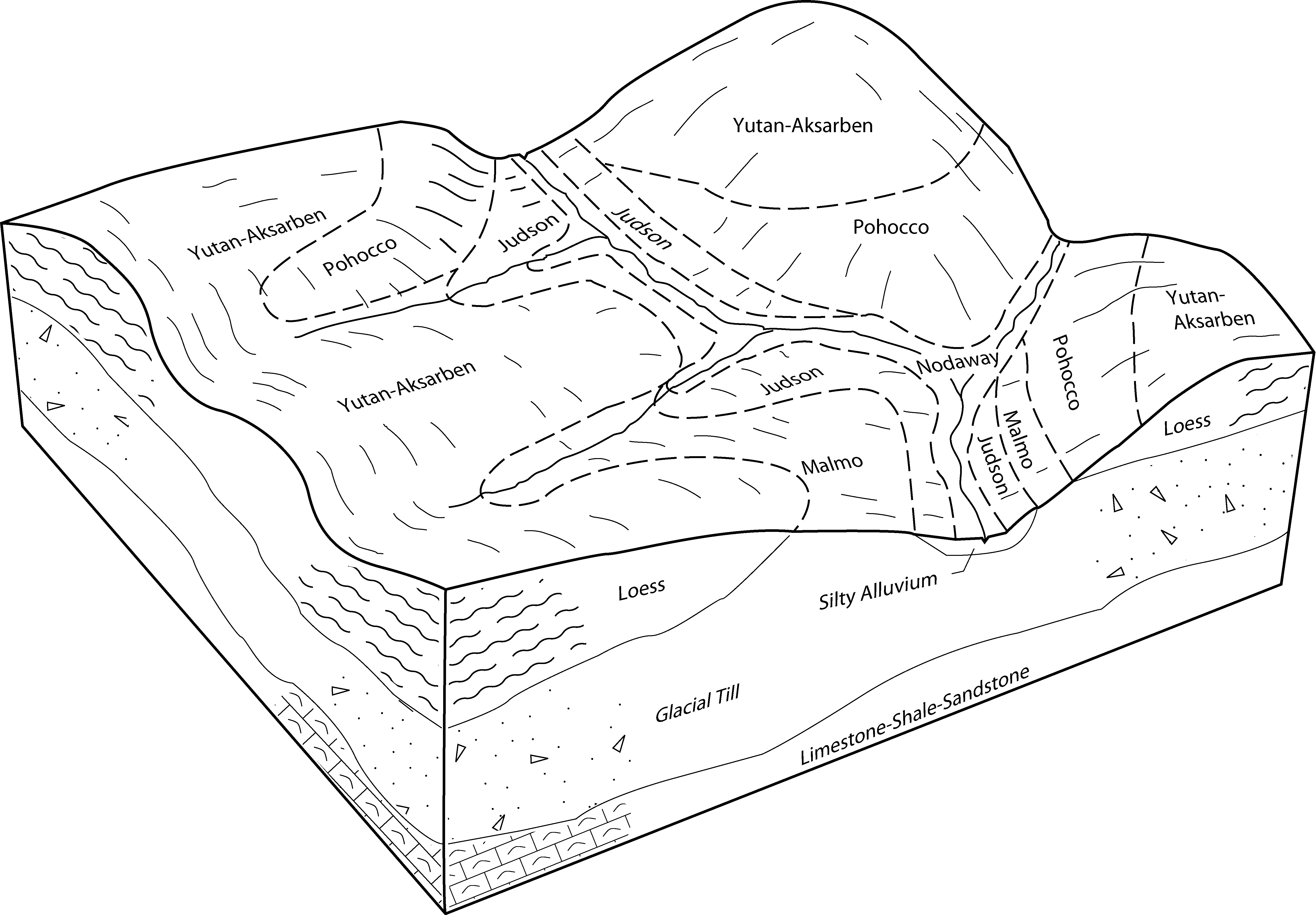
Colo-Judson-Nodaway complex, 0 to 5 percent slopes | 286B | 31511 | 411612 | 2wxsh | ia173 | 1989 | 1:15840 |
Judson silty clay loam, dissected till plain, 2 to 5 percent slopes | 8B | 404 | 411661 | 2sy6z | ia173 | 1989 | 1:15840 |
Judson silty clay loam, dissected till plain, 5 to 9 percent slopes | 8C | 151 | 411662 | 2sy72 | ia173 | 1989 | 1:15840 |
Judson silty clay loam, dissected till plain, 2 to 5 percent slopes | 8B | 436 | 411737 | 2sy6z | ia175 | 1975 | 1:15840 |
Judson silty clay loam, dissected till plain, 2 to 5 percent slopes | 8B | 566 | 411977 | 2sy6z | ia181 | 1975 | 1:15840 |
Judson silty clay loam, deep loess, 5 to 9 percent slopes | 8C | 14915 | 401885 | 2sy71 | ia193 | 2003 | 1:12000 |
Judson silty clay loam, deep loess, 2 to 5 percent slopes | 8B | 11062 | 401982 | 2sy6y | ia193 | 2003 | 1:12000 |
Smithland-Danbury-Judson complex, 0 to 5 percent slopes | 666B | 5022 | 741629 | 2zv9n | ia193 | 2003 | 1:12000 |
Judson-Rawles complex, 0 to 5 percent slopes | 847B | 3617 | 402138 | 2zv9g | ia193 | 2003 | 1:12000 |
Judson silt loam, 1 to 5 percent slopes | 7851 | 1817 | 1475388 | 2x6bp | ks005 | 1998 | 1:24000 |
Judson silt loam, 1 to 5 percent slopes | 7851 | 2731 | 1152191 | 2x6bp | ks013 | 1994 | 1:24000 |
Judson silt loam, 1 to 5 percent slopes | 7851 | 3704 | 747161 | 2x6bp | ks043 | 1977 | 1:24000 |
Judson silt loam, rarely flooded | 7852 | 5 | 1468859 | 1l9gk | ks045 | 1974 | 1:24000 |
Judson silt loam, 0 to 1 percent slopes | 7850 | 1433 | 1862409 | 20hzq | ks103 | 1973 | 1:24000 |
Judson silt loam, 1 to 5 percent slopes | 7851 | 83 | 1406037 | 2x6bp | ks131 | 1980 | 1:24000 |
Judson silt loam, 2 to 6 percent slopes | 7231 | 3 | 2505150 | 2x6bq | ks131 | 1980 | 1:24000 |
Judson silt loam, 2 to 6 percent slopes | 7231 | 6 | 2559430 | 2x6bq | ks201 | 1988 | 1:24000 |
Judson silt loam, 0 to 1 percent slopes | 7850 | 410 | 1862297 | 20hw3 | ks209 | 1973 | 1:24000 |
Chaseburg and Judson silt loams, 2 to 6 percent slopes | Cb | 12553 | 2216705 | 2ddnm | mn045 | 2008 | 1:12000 |
Chaseburg and Judson silt loams, 0 to 1 percent slopes | Ca | 3381 | 2216704 | 2ddnl | mn045 | 2008 | 1:12000 |
Judson silty clay loam, 3 to 8 percent slopes | P20B | 325 | 725695 | 2zv9d | mn101 | 2008 | 1:12000 |
Judson silty clay loam, 3 to 8 percent slopes | P20B | 238 | 630067 | 2zv9d | mn105 | 2004 | 1:12000 |
Judson silt loam, 2 to 7 percent slopes | 10037 | 4355 | 2521098 | 2qkyd | mo003 | 1986 | 1:24000 |
Colo, frequently flooded-Judson silty clay loams, 0 to 5 percent slopes | 13627 | 1751 | 2607693 | 2sy7k | mo003 | 1986 | 1:24000 |
Colo, frequently flooded-Judson silty clay loams, 0 to 5 percent slopes | 13627 | 10816 | 2671841 | 2sy7k | mo005 | 1988 | 1:24000 |
Colo-Judson silty clay loams, 0 to 5 percent slopes, occasionally flooded | 13511 | 4953 | 2528367 | 2sy7j | mo005 | 1988 | 1:24000 |
Judson silty clay loam, deep loess, 2 to 5 percent slopes | 10187 | 3681 | 2521097 | 2sy6y | mo005 | 1988 | 1:24000 |
Kenridge-Judson complex, 1 to 7 percent slopes | 10039 | 436 | 2521101 | 2qkyf | mo005 | 1988 | 1:24000 |
Judson-Colo complex, 1 to 5 percent slopes | 10038 | 3201 | 913496 | znkm | mo021 | 1984 | 1:24000 |
Judson silt loam, 2 to 7 percent slopes | 10037 | 2005 | 2521096 | 2qkyd | mo021 | 1984 | 1:24000 |
Colo-Judson silty clay loams, 0 to 5 percent slopes | 13627 | 117 | 2607696 | 2qhz5 | mo075 | 1982 | 1:24000 |
Colo, frequently flooded-Judson silty clay loams, 0 to 5 percent slopes | 13627 | 15077 | 2671842 | 2sy7k | mo087 | 1992 | 1:24000 |
Kenridge-Judson complex, 1 to 7 percent slopes | 10039 | 6782 | 2521100 | 2qkyf | mo087 | 1992 | 1:24000 |
Nodaway-Judson silt loams, 1 to 7 percent slopes | 13564 | 2958 | 887524 | ysjt | mo087 | 1992 | 1:24000 |
Colo, frequently flooded-Judson silty clay loams, 0 to 5 percent slopes | 13627 | 14951 | 2671843 | 2sy7k | mo147 | 1983 | 1:24000 |
Judson silt loam, 2 to 6 percent slopes | 7231 | 7556 | 1691294 | 2x6bq | ne023 | 1979 | 1:20000 |
Yutan, eroded-Judson complex, 6 to 11 percent slopes | 7646 | 1309 | 2219045 | 2scyn | ne023 | 1979 | 1:20000 |
Judson silt loam, 0 to 2 percent slopes | 7230 | 29 | 2219040 | 2dh2y | ne023 | 1979 | 1:20000 |
Judson silt loam, 2 to 6 percent slopes | 7231 | 16500 | 1691471 | 2x6bq | ne025 | 1981 | 1:20000 |
Yutan, eroded-Judson complex, 6 to 11 percent slopes | 7646 | 1950 | 2216032 | 2scyn | ne025 | 1981 | 1:20000 |
Judson silt loam, 0 to 2 percent slopes | 7230 | 1394 | 1691470 | 1ts3k | ne025 | 1981 | 1:20000 |
Judson silty clay loam, 2 to 6 percent slopes | 7234 | 8264 | 1710950 | 2sy70 | ne055 | 2007 | 1:12000 |
Urban land-Udorthents-Judson complex, 0 to 11 percent slopes | 9718 | 5046 | 1710979 | 2sy75 | ne055 | 2007 | 1:12000 |
Pohocco-Judson complex, 1 to 30 percent slopes | 8140 | 1169 | 1710964 | 2zv9h | ne055 | 2007 | 1:12000 |
Judson-Nodaway channeled-Contrary complex, 0 to 12 percent slopes | 7235 | 492 | 1710951 | 2zv9f | ne055 | 2007 | 1:12000 |
Judson silt loam, 2 to 6 percent slopes | 7231 | 17770 | 1691104 | 2x6bq | ne067 | 2000 | 1:12000 |
Judson silt loam, 2 to 6 percent slopes | 7231 | 3718 | 1691767 | 1tsf4 | ne095 | 1970 | 1:20000 |
Judson silt loam, 2 to 6 percent slopes | 7231 | 10659 | 1691574 | 2x6bq | ne097 | 1984 | 1:20000 |
Judson silt loam, 2 to 6 percent slopes | 7231 | 27435 | 1691360 | 2x6bq | ne109 | 1977 | 1:20000 |
Urban land-Judson complex, 1 to 3 percent slopes | 9708 | 1304 | 1691395 | 1ts14 | ne109 | 1977 | 1:20000 |
Yutan, eroded-Judson complex, 6 to 11 percent slopes | 7646 | 889 | 2219243 | 2scyn | ne109 | 1977 | 1:20000 |
Judson fine sandy loam, 2 to 6 percent slopes | 7232 | 307 | 1691359 | 1trzz | ne109 | 1977 | 1:20000 |
Judson silt loam, 2 to 6 percent slopes | 7231 | 11572 | 1691664 | 2x6bq | ne127 | 1983 | 1:20000 |
Judson silt loam, 0 to 2 percent slopes | 7230 | 795 | 1691663 | 1ts9s | ne127 | 1983 | 1:20000 |
Judson silt loam, 2 to 6 percent slopes | 7231 | 18638 | 1691527 | 2x6bq | ne131 | 1979 | 1:20000 |
Judson silt loam, 0 to 2 percent slopes | 7230 | 732 | 1691526 | 1ts5c | ne131 | 1979 | 1:20000 |
Judson silt loam, 2 to 6 percent slopes | 7231 | 14450 | 1691615 | 2x6bq | ne133 | 1969 | 1:15840 |
Judson silt loam, 2 to 6 percent slopes | 7231 | 18244 | 1691041 | 2x6bq | ne147 | 1967 | 1:20000 |
Judson silt loam, 2 to 6 percent slopes | 7231 | 517 | 2219185 | 2x6bq | ne151 | 1985 | 1:20000 |
Judson silty clay loam, 2 to 6 percent slopes | 7234 | 9899 | 1711014 | 2sy70 | ne153 | 2007 | 1:12000 |
Judson-Nodaway channeled-Contrary complex, 0 to 12 percent slopes | 7235 | 2782 | 1711015 | 2zv9f | ne153 | 2007 | 1:12000 |
Urban land-Udorthents-Judson complex, 0 to 11 percent slopes | 9718 | 1281 | 1711043 | 2sy75 | ne153 | 2007 | 1:12000 |
Pohocco-Judson complex, 1 to 30 percent slopes | 8140 | 838 | 1711028 | 2zv9h | ne153 | 2007 | 1:12000 |
Yutan, eroded-Judson complex, 6 to 11 percent slopes | 7646 | 106745 | 1691454 | 2scyn | ne155 | 1995 | 1:12000 |
Judson silt loam, 2 to 6 percent slopes | 7231 | 24534 | 1691426 | 2x6bq | ne155 | 1995 | 1:12000 |
Judson silt loam, 0 to 2 percent slopes | 7230 | 3511 | 1691425 | 1ts23 | ne155 | 1995 | 1:12000 |
Judson silt loam, 2 to 6 percent slopes | 7231 | 438 | 2219127 | 2x6bq | ne159 | 1967 | 1:20000 |
Judson silty clay loam, 2 to 6 percent slopes | 7234 | 19499 | 395541 | 2sy70 | ne177 | 2000 | 1:12000 |
Judson-Nodaway channeled-Contrary complex, 0 to 12 percent slopes | 7235 | 192 | 2217303 | 2zv9f | ne177 | 2000 | 1:12000 |
Judson silt loam, 3 to 10 percent slopes | 624C | 3006 | 424283 | g7hk | wi043 | 1959 | 1:20000 |
Judson silt loam, 0 to 3 percent slopes | 624A | 2163 | 424282 | g7hj | wi043 | 1959 | 1:20000 |
Judson silt loam, 2 to 6 percent slopes | 624B | 3631 | 424645 | g7w7 | wi049 | 1960 | 1:20000 |
Judson silt loam, 0 to 2 percent slopes | 624A | 2092 | 424644 | g7w6 | wi049 | 1960 | 1:20000 |
Judson silt loam, 6 to 12 percent slopes | 624C | 287 | 424646 | g7w8 | wi049 | 1960 | 1:20000 |
