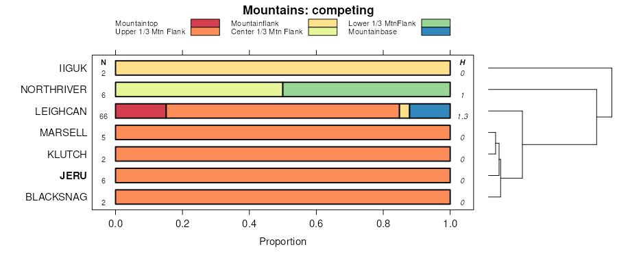
| Jeru gravelly sandy loam, warm, 35 to 75 percent slopes, extremely stony | 19 | 13060 | 152973 | 545m | id604 | 1981 | 1:24000 |
Jeru gravelly loam, 35 to 65 percent slopes, extremely stony | 17 | 11112 | 152971 | 545k | id604 | 1981 | 1:24000 |
Jeru gravelly sandy loam, warm, 5 to 35 percent slopes, extremely stony | 18 | 4433 | 152972 | 545l | id604 | 1981 | 1:24000 |
Jeru gravelly sandy loam, warm, 35 to 75 percent slopes, extremely stony | 545m | 170 | 2936666 | 545m | id670 | | 1:24000 |
Jeru gravelly loam, 35 to 65 percent slopes, extremely stony | 545k | 113 | 2936685 | 545k | id670 | | 1:24000 |
Jeru gravelly sandy loam, warm, 5 to 35 percent slopes, extremely stony | 545l | 3 | 2936701 | 545l | id670 | | 1:24000 |
Jeru family-Rubble land-Rock outcrop association, trough walls | 49D41 | 3235 | 3330190 | 51fl | id671 | 1989 | 1:24000 |
Jeru family-Hargran family-Rubble land association, trough walls, extremely bouldery | 49G45 | 1504 | 3417880 | 51fr | id671 | 1989 | 1:24000 |
Rock outcrop-Jeru-Rubycreek families, complex, cirque headwalls | 217Vra | 9792 | 149083 | 5044 | mt605 | 2007 | 1:24000 |
Rock outcrop-Rubycreek-Jeru families, complex, trough walls | 227Vra | 6766 | 149364 | 50f6 | mt605 | 2007 | 1:24000 |
Jeru-Cowood-Rubycreek families, complex, mountain ridgetops | 107Vra | 6581 | 149367 | 50f9 | mt605 | 2007 | 1:24000 |
Rock outcrop-Sig-Jeru families, complex, moderately steep trough bottoms | 37UE3 | 23287 | 149437 | 50hk | mt635 | 2006 | 1:24000 |
Ovando-Jeru-Roman families, complex, steep glaciated mountain slopes and ridges | 15GE2 | 3455 | 149378 | 50fn | mt635 | 2006 | 1:24000 |
Leighcan-Kurrie-Jeru families, complex, nivational mountain slopes and ridges | 75GEB | 566 | 149525 | 50ld | mt635 | 2006 | 1:24000 |
Jeru family-Rubble land-Rock outcrop association, trough walls | 49D41 | 160 | 2422735 | 2mb1r | mt638 | 1985 | 1:24000 |
Jeru-Crawfish families-Rock outcrop complex, trough walls | 49B15 | 145 | 2422734 | 2mb1q | mt638 | 1985 | 1:24000 |
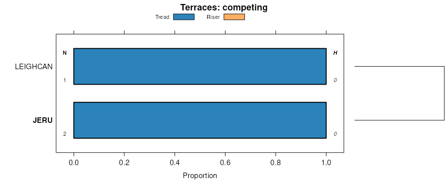
Beehive-Jeru-Jurvannah families, complex, flood plains and terraces | 10P10 | 1404 | 1687592 | 1tn2g | mt645 | 2013 | 1:12000 |
Jeru family-Rubble land-Rock outcrop association, trough walls | 49D41 | 168 | 633787 | p8hr | mt645 | 2013 | 1:12000 |
Jeru-Shermount families-Rock outcrop complex, trough walls | 49B15 | 133 | 633786 | 51fk | mt645 | 2013 | 1:12000 |
Jeru family-Rubble land-Rock outcrop association, trough walls | 49D41 | 31273 | 150337 | 51fl | mt647 | 2007 | 1:24000 |
Jeru family-Hargran family-Rubble land association, trough walls, extremely bouldery | 49G45 | 17006 | 150342 | 51fr | mt647 | 2007 | 1:24000 |
Jeru-Shermount families-Rock outcrop complex, trough walls | 49B15 | 13308 | 150336 | 51fk | mt647 | 2007 | 1:24000 |
Rubycreek-Jeru families-Rubble land association, trough walls | 49G23 | 7557 | 150341 | 51fq | mt647 | 2007 | 1:24000 |
Beehive-Jeru-Jurvannah families, complex, flood plains and terraces | 10P10 | 6831 | 150215 | 519n | mt647 | 2007 | 1:24000 |
Rubble land-Jeru family-Rock outcrop association, trough walls | 49B13 | 6476 | 150335 | 51fj | mt647 | 2007 | 1:24000 |
Jeru-Lilylake-Rubycreek families, complex, moraines | 44D42 | 4979 | 150326 | 51f7 | mt647 | 2007 | 1:24000 |
Rubycreek-Jeru families, association, trough walls | 49D44 | 3565 | 150339 | 51fn | mt647 | 2007 | 1:24000 |
Rubycreek-Jeru-Jurvannah families, complex, trough bottoms, moist | 47D42 | 2228 | 150330 | 51fc | mt647 | 2007 | 1:24000 |
Jeru family-Rock outcrop complex, steep mountain slopes, extremely bouldery | 30D13 | 540 | 150231 | 51b5 | mt647 | 2007 | 1:24000 |
Rubycreek-Jeru-Jurvannah families, complex, trough bottoms | 47G41 | 524 | 150332 | 51ff | mt647 | 2007 | 1:24000 |
Southeast Mountains Moraines, Subalpine Fir-Meadow Complex | 7342 | 1052 | 2554708 | 5327 | wy635 | | 1:24000 |
Subsummit Sideslopes, Rock Outcrop-Whitebark Pine-Subalpine Fir Complex | 2602 | 434 | 2554687 | 52zy | wy635 | | 1:24000 |
Southeast Mountains Moraines, Subalpine Fir Complex | 7343 | 408 | 2554709 | 5328 | wy635 | | 1:24000 |
Jeru-Swapps-McCall families, complex, 7 to 40 percent slopes | 611 | 11095 | 1857235 | 20blt | wy647 | | 1:24000 |
Rock outcrop-Elting-Jeru families, complex, 15 to 60 percent slopes | 609 | 867 | 1857224 | 20blg | wy647 | | 1:24000 |
Jeru-Elting families-Rock outcrop complex, 7 to 60 percent slopes | 616 | 266 | 1862626 | 20j6q | wy647 | | 1:24000 |
Jeru-Swapps-McCall families, complex, 7 to 40 percent slopes | 327S | 64428 | 1686557 | 1tm02 | wy656 | 2008 | 1:24000 |
Rock outcrop-Elting-Jeru families, complex, 15 to 60 percent slopes | 311L | 37507 | 1683198 | 1thhq | wy656 | 2008 | 1:24000 |
Jeru-Elting families-Rock outcrop complex, 7 to 60 percent slopes | 310L | 30406 | 1685583 | 1tkzn | wy656 | 2008 | 1:24000 |
Subsummit Sideslopes, Rock Outcrop-Whitebark Pine-Subalpine Fir Complex | 2602 | 31456 | 151836 | 52zy | wy662 | 1998 | 1:24000 |
Glacial Trough Sideslopes, Subalpine Fir Complex | 5741 | 17556 | 151890 | 531p | wy662 | 1998 | 1:24000 |
Southeast Mountains Moraines, Subalpine Fir Complex | 7343 | 14835 | 151908 | 5328 | wy662 | 1998 | 1:24000 |
Glacial Trough Sideslopes, Rock Outcrop-Rubble Land-Subalpine Fir Complex | 5702 | 10459 | 151889 | 531n | wy662 | 1998 | 1:24000 |
Southeast Mountains Sideslopes, Subalpine Fir-Meadow Complex | 7644 | 8679 | 151913 | 532f | wy662 | 1998 | 1:24000 |
Southeast Mountains Sideslopes, Rubble Land-Subalpine Fir-Whitebark Pine Complex | 7603 | 8379 | 151926 | 532v | wy662 | 1998 | 1:24000 |
Southeast Mountains Moraines, Subalpine Fir-Meadow Complex | 7342 | 3654 | 151907 | 5327 | wy662 | 1998 | 1:24000 |

