| Jayem fine sandy loam, 3 to 6 percent slopes | 5966 | 25 | 2228147 | 2dskq | ne007 | 1988 | 1:20000 |
Busher-Jayem loamy very fine sands, 3 to 6 percent slopes | 5134 | 12738 | 357771 | 30wpc | ne013 | 1980 | 1:20000 |
Busher-Jayem loamy very fine sands, 0 to 3 percent slopes | 5133 | 10078 | 357770 | 30wpb | ne013 | 1980 | 1:20000 |
Jayem fine sandy loam, 0 to 3 percent slopes | 5965 | 7017 | 357800 | 2tvtr | ne013 | 1980 | 1:20000 |
Jayem loamy fine sand, 0 to 3 percent slopes | 5970 | 2368 | 357799 | 2wcbm | ne013 | 1980 | 1:20000 |
Busher-Jayem loamy very fine sands, 6 to 9 percent slopes | 5135 | 2159 | 357772 | 30wnz | ne013 | 1980 | 1:20000 |
Jayem fine sandy loam, 3 to 6 percent slopes | 5966 | 1465 | 357801 | 2tvts | ne013 | 1980 | 1:20000 |
Jayem loamy sand, overblown, 0 to 3 percent slopes | 5974 | 1062 | 357798 | d09w | ne013 | 1980 | 1:20000 |
Jayem loamy very fine sand, 0 to 3 percent slopes | 5976 | 106 | 2217457 | 2tvv9 | ne013 | 1980 | 1:20000 |
Jayem loamy fine sand, 0 to 3 percent slopes | 5970 | 9158 | 1699031 | 1v0zg | ne029 | 1980 | 1:20000 |
Jayem fine sandy loam, 0 to 3 percent slopes | 5965 | 5680 | 1699033 | 1v0zj | ne029 | 1980 | 1:20000 |
Jayem loamy fine sand, 3 to 6 percent slopes | 5972 | 2611 | 1699032 | 1v0zh | ne029 | 1980 | 1:20000 |
Jayem fine sandy loam, 3 to 6 percent slopes | 5966 | 1873 | 1699034 | 1v0zk | ne029 | 1980 | 1:20000 |
Jayem loamy very fine sand, 3 to 6 percent slopes | 5979 | 98 | 2219546 | 2dhm8 | ne029 | 1980 | 1:20000 |
Jayem loamy sand, 0 to 3 percent slopes | 5973 | 63 | 2219513 | 2dhl6 | ne029 | 1980 | 1:20000 |
Jayem loamy very fine sand, 0 to 3 percent slopes | 5976 | 53 | 2219545 | 2dhm7 | ne029 | 1980 | 1:20000 |
Jayem fine sandy loam, 3 to 6 percent slopes | 5966 | 6065 | 1698687 | 2tvts | ne033 | 1989 | 1:20000 |
Jayem fine sandy loam, 0 to 3 percent slopes | 5965 | 4587 | 1698686 | 2tvtr | ne033 | 1989 | 1:20000 |
Jayem loamy very fine sand, 1 to 6 percent slopes | 5978 | 3384 | 358110 | d0my | ne045 | 1973 | 1:20000 |
Jayem and Vetal loamy very fine sands, 6 to 9 percent slopes | 5964 | 3238 | 358112 | d0n0 | ne045 | 1973 | 1:20000 |
Jayem loamy very fine sand, 6 to 9 percent slopes | 5980 | 2930 | 358111 | 2tvvc | ne045 | 1973 | 1:20000 |
Busher-Jayem loamy very fine sands, 6 to 9 percent slopes | 5135 | 668 | 2217576 | 30wnz | ne045 | 1973 | 1:20000 |
Busher-Jayem loamy very fine sands, 3 to 6 percent slopes | 5134 | 338 | 2217575 | 30wpc | ne045 | 1973 | 1:20000 |
Busher-Jayem loamy very fine sands, 0 to 3 percent slopes | 5133 | 190 | 2217574 | 30wpb | ne045 | 1973 | 1:20000 |
Jayem loamy very fine sand, 3 to 6 percent slopes | 5979 | 83 | 2217539 | 2tvvb | ne045 | 1973 | 1:20000 |
Jayem fine sandy loam, 3 to 6 percent slopes | 5966 | 60 | 2217567 | 2tvts | ne045 | 1973 | 1:20000 |
Jayem fine sandy loam, 0 to 3 percent slopes | 5965 | 36 | 2217566 | 2tvtr | ne045 | 1973 | 1:20000 |
Jayem fine sandy loam, 0 to 3 percent slopes | 5965 | 1349 | 1698807 | 1v0r7 | ne049 | 2000 | 1:24000 |
Jayem loamy sand, 0 to 3 percent slopes | 5973 | 23766 | 1699091 | 1v11d | ne057 | 1995 | 1:24000 |
Jayem loamy very fine sand, 1 to 3 percent slopes | 5977 | 243 | 1699413 | 1v1cs | ne063 | 1973 | 1:20000 |
Jayem loamy very fine sand, 0 to 3 percent slopes | 5976 | 124 | 2219350 | 2dhdy | ne063 | 1973 | 1:20000 |
Jayem loamy fine sand, 0 to 3 percent slopes | 5970 | 11497 | 1698749 | 2wcbm | ne069 | 1995 | 1:20000 |
Jayem fine sandy loam, 3 to 6 percent slopes | 5966 | 5535 | 1698752 | 2tvts | ne069 | 1995 | 1:20000 |
Jayem fine sandy loam, 0 to 3 percent slopes | 5965 | 5091 | 1698751 | 2tvtr | ne069 | 1995 | 1:20000 |
Jayem loamy fine sand, 3 to 6 percent slopes | 5972 | 2404 | 1698750 | 2wcbn | ne069 | 1995 | 1:20000 |
Jayem loamy very fine sand, 0 to 3 percent slopes | 5976 | 17249 | 1699246 | 1v16d | ne085 | 1981 | 1:20000 |
Jayem loamy very fine sand, 3 to 6 percent slopes | 5979 | 6557 | 1699247 | 1v16f | ne085 | 1981 | 1:20000 |
Jayem loamy fine sand, 0 to 3 percent slopes | 5970 | 488 | 2228828 | 2dt8p | ne085 | 1981 | 1:20000 |
Jayem fine sandy loam, 1 to 3 percent slopes | 5963 | 2005 | 1699279 | 1v17g | ne087 | 1965 | 1:20000 |
Jayem fine sandy loam, 0 to 1 percent slopes | 5962 | 246 | 1699278 | 1v17f | ne087 | 1965 | 1:20000 |
Jayem loamy fine sand, 0 to 3 percent slopes | 5970 | 200 | 1699282 | 1v17k | ne087 | 1965 | 1:20000 |
Jayem fine sandy loam, 0 to 3 percent slopes | 5965 | 1707 | 1692544 | 1tt76 | ne105 | 2004 | 1:24000 |
Jayem fine sandy loam, 3 to 6 percent slopes | 5966 | 926 | 1692545 | 1tt77 | ne105 | 2004 | 1:24000 |
Jayem loamy very fine sand, 0 to 3 percent slopes | 5976 | 173 | 2219747 | 2dhtr | ne111 | 1971 | 1:24000 |
Jayem loamy very fine sand, 3 to 6 percent slopes | 5979 | 173 | 2219748 | 2dhts | ne111 | 1971 | 1:24000 |
Jayem fine sandy loam, 3 to 6 percent slopes | 5966 | 50 | 2219774 | 2dhvm | ne111 | 1971 | 1:24000 |
Jayem fine sandy loam, 0 to 3 percent slopes | 5965 | 11761 | 1692621 | 2tvtr | ne123 | 1981 | 1:20000 |
Jayem fine sandy loam, 3 to 6 percent slopes | 5966 | 9276 | 1692622 | 2tvts | ne123 | 1981 | 1:20000 |
Jayem loamy fine sand, 3 to 6 percent slopes | 5972 | 8444 | 1692620 | 2wcbn | ne123 | 1981 | 1:20000 |
Jayem fine sandy loam, 6 to 9 percent slopes | 5967 | 6338 | 1692623 | 1tt9r | ne123 | 1981 | 1:20000 |
Jayem fine sandy loam, 9 to 20 percent slopes | 5968 | 2827 | 1692624 | 1tt9s | ne123 | 1981 | 1:20000 |
Jayem loamy fine sand, 0 to 3 percent slopes | 5970 | 2673 | 1692619 | 2wcbm | ne123 | 1981 | 1:20000 |
Busher-Jayem loamy very fine sands, 3 to 6 percent slopes | 5134 | 42 | 2220376 | 30wpc | ne123 | 1981 | 1:20000 |
Jayem fine sandy loam, 0 to 3 percent slopes | 5965 | 503 | 1698969 | 1v0xg | ne135 | 1987 | 1:20000 |
Jayem loamy fine sand, 0 to 3 percent slopes | 5970 | 458 | 1698968 | 1v0xf | ne135 | 1987 | 1:20000 |
Jayem fine sandy loam, 3 to 6 percent slopes | 5966 | 350 | 1698970 | 1v0xh | ne135 | 1987 | 1:20000 |
Jayem fine sandy loam, 6 to 9 percent slopes | 5967 | 4712 | 1653714 | 1shtm | ne157 | 1965 | 1:20000 |
Jayem fine sandy loam, 9 to 20 percent slopes | 5968 | 3450 | 1653715 | 1shtn | ne157 | 1965 | 1:20000 |
Jayem fine sandy loam, 3 to 6 percent slopes | 5966 | 3395 | 1653713 | 2tvts | ne157 | 1965 | 1:20000 |
Jayem fine sandy loam, 0 to 3 percent slopes | 5965 | 2588 | 1653712 | 2tvtr | ne157 | 1965 | 1:20000 |
Jayem loamy very fine sand, 6 to 9 percent slopes | 5980 | 455 | 2227677 | 2tvvc | ne157 | 1965 | 1:20000 |
Jayem loamy very fine sand, 3 to 6 percent slopes | 5979 | 267 | 2227676 | 2tvvb | ne157 | 1965 | 1:20000 |
Busher-Jayem loamy very fine sands, 3 to 6 percent slopes | 5134 | 227 | 2227689 | 30wpc | ne157 | 1965 | 1:20000 |
Busher-Jayem loamy very fine sands, 0 to 3 percent slopes | 5133 | 174 | 2227699 | 30wpb | ne157 | 1965 | 1:20000 |
Jayem loamy very fine sand, 0 to 3 percent slopes | 5976 | 17 | 2227675 | 2tvv9 | ne157 | 1965 | 1:20000 |
Jayem fine sandy loam, 0 to 3 percent slopes | 5965 | 6662 | 100596 | 2tvtr | ne161 | 1992 | 1:20000 |
Jayem fine sandy loam, 3 to 6 percent slopes | 5966 | 6628 | 100597 | 2tvts | ne161 | 1992 | 1:20000 |
Jayem fine sandy loam, 6 to 9 percent slopes | 5967 | 612 | 100598 | 3cp3 | ne161 | 1992 | 1:20000 |
Jayem loamy very fine sand, 0 to 3 percent slopes | 5976 | 42340 | 357919 | 2tvv9 | ne165 | 1993 | 1:20000 |
Jayem loamy very fine sand, 3 to 6 percent slopes | 5979 | 21517 | 357920 | 2tvvb | ne165 | 1993 | 1:20000 |
Jayem loamy very fine sand, 6 to 9 percent slopes | 5980 | 2398 | 357921 | 2tvvc | ne165 | 1993 | 1:20000 |
Jayem fine sandy loam, 2 to 9 percent slopes | JaB | 6760 | 355112 | cxj7 | sd047 | 1980 | 1:24000 |
Jayem fine sandy loam, 2 to 9 percent slopes | P180C | 167 | 2733133 | 2qt39 | sd047 | 1980 | 1:24000 |
Jayem fine sandy loam, 3 to 9 percent slopes | JaC | 8833 | 2580916 | 2tvv1 | sd606 | 2011 | 1:24000 |
Jayem fine sandy loam, 0 to 3 percent slopes | JaA | 4861 | 2580915 | 2tvtr | sd606 | 2011 | 1:24000 |
Jayem-Valentine, dry complex, 6 to 30 percent slopes | U348E | 38 | 2582916 | 2pf56 | sd606 | 2011 | 1:24000 |
Tuthill-Jayem fine sandy loams, 3 to 9 percent slopes | U740C | 4 | 2582935 | 2pd6c | sd606 | 2011 | 1:24000 |
Tuthill-Jayem fine sandy loams, 3 to 9 percent slopes | U740C | 1837 | 2484382 | 2pd6c | sd612 | 2011 | 1:20000 |
Jayem-Valentine, dry complex, 6 to 30 percent slopes | U348E | 1777 | 2485307 | 2pf56 | sd612 | 2011 | 1:20000 |
Tuthill-Jayem fine sandy loams, 0 to 3 percent slopes | U740A | 268 | 2484380 | 2pd69 | sd612 | 2011 | 1:20000 |
Jayem-Valentine, dry complex, 6 to 30 percent slopes | U348E | 1723 | 2582829 | 2pf56 | sd613 | 2011 | 1:24000 |
Tuthill-Jayem fine sandy loams, 3 to 9 percent slopes | U740C | 1469 | 2582849 | 2pd6c | sd613 | 2011 | 1:24000 |
Jayem fine sandy loam, 6 to 9 percent slopes | T178C | 709 | 2582801 | 1hv5z | sd613 | 2011 | 1:24000 |
Jayem fine sandy loam, 3 to 6 percent slopes | T178B | 173 | 2582800 | 1hv5y | sd613 | 2011 | 1:24000 |
Jayem fine sandy loam, 0 to 3 percent slopes | T178A | 166 | 2582799 | 1hv5x | sd613 | 2011 | 1:24000 |
Tuthill-Jayem fine sandy loams, 0 to 3 percent slopes | U740A | 162 | 2582848 | 2pd69 | sd613 | 2011 | 1:24000 |
Jayem-Julesburg fine sandy loams, 0 to 6 percent slopes | 144 | 74952 | 349602 | 2tvv7 | wy027 | 1993 | 1:24000 |
Jayem-Phiferson-Trelona fine sandy loams, 3 to 10 percent slopes | 146 | 67994 | 349606 | 2tvv6 | wy027 | 1993 | 1:24000 |
Jayem-Julesburg fine sandy loams, 6 to 15 percent slopes | 145 | 32305 | 349604 | 2tvv8 | wy027 | 1993 | 1:24000 |
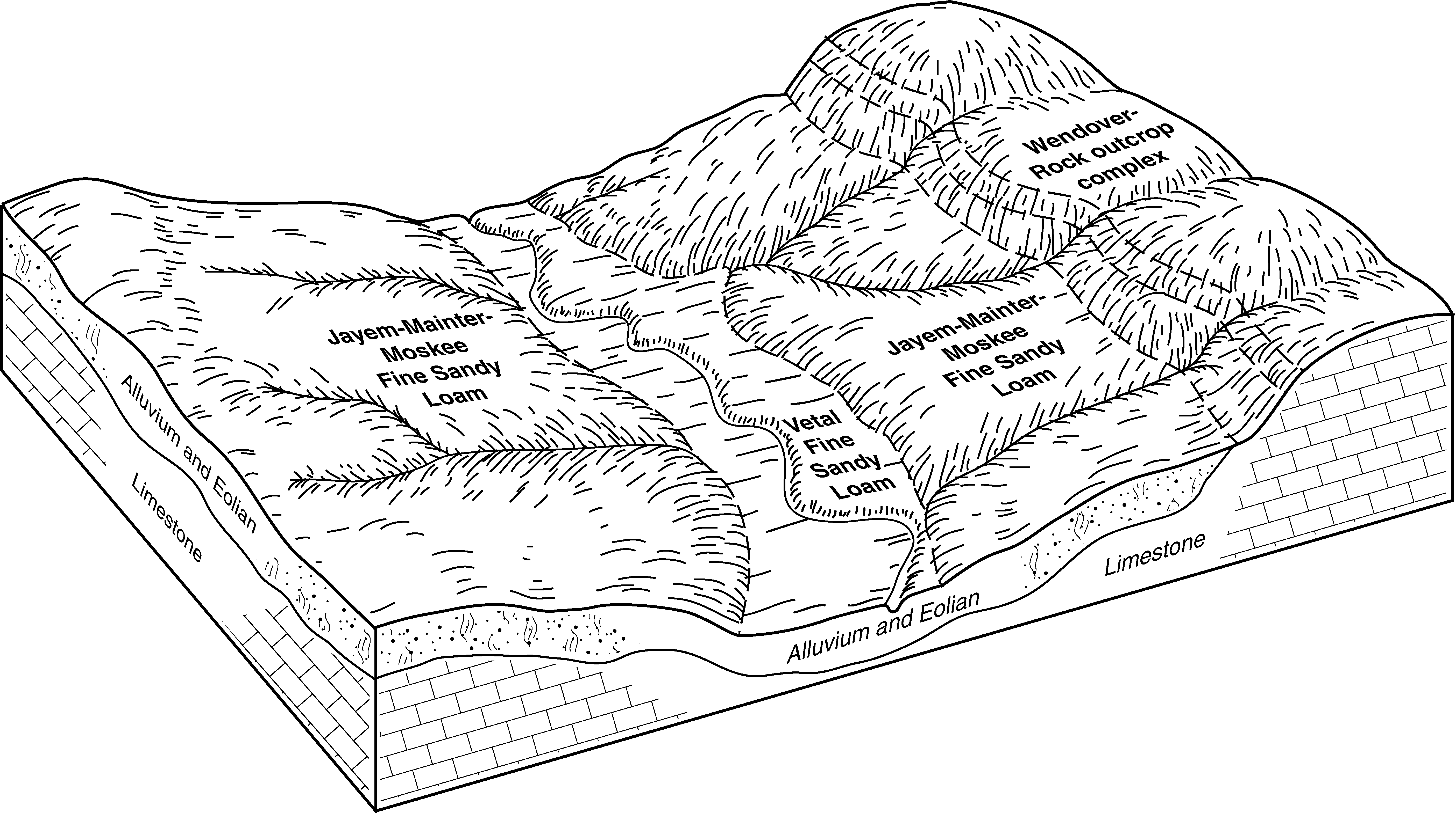
Jayem-Mainter-Moskee fine sandy loams, 0 to 6 percent slopes | 172 | 18655 | 104525 | 3hrs | wy031 | 1998 | 1:24000 |
Julesburg-Jayem-Phiferson fine sandy loams, 0 to 6 percent slopes | 173 | 3378 | 104526 | 3hrt | wy031 | 1998 | 1:24000 |
Jayem fine sandy loam, 6 to 20 percent slopes | 165 | 1906 | 349857 | cr1q | wy605 | 1995 | 1:24000 |
Jayem-Phiferson-Trelona fine sandy loams, 3 to 10 percent slopes | 178 | 4358 | 1669700 | 2tvv6 | wy609 | 2006 | 1:24000 |
Jayem-Julesburg fine sandy loams, 0 to 6 percent slopes | 176 | 2553 | 1669698 | 2tvv7 | wy609 | 2006 | 1:24000 |
Jayem-Julesburg fine sandy loams, 6 to 15 percent slopes | 177 | 701 | 1669699 | 2tvv8 | wy609 | 2006 | 1:24000 |
Jayem fine sandy loam, 0 to 3 percent slopes | 17 | 3730 | 104805 | 3j1t | wy621 | 1980 | 1:24000 |
Jayem fine sandy loam, 3 to 6 percent slopes | 18 | 1810 | 104806 | 3j1v | wy621 | 1980 | 1:24000 |
Jayem-Manter-Trelona complex, 3 to 20 percent slopes | 16D | 66023 | 104857 | 2wcbr | wy715 | 1974 | 1:20000 |
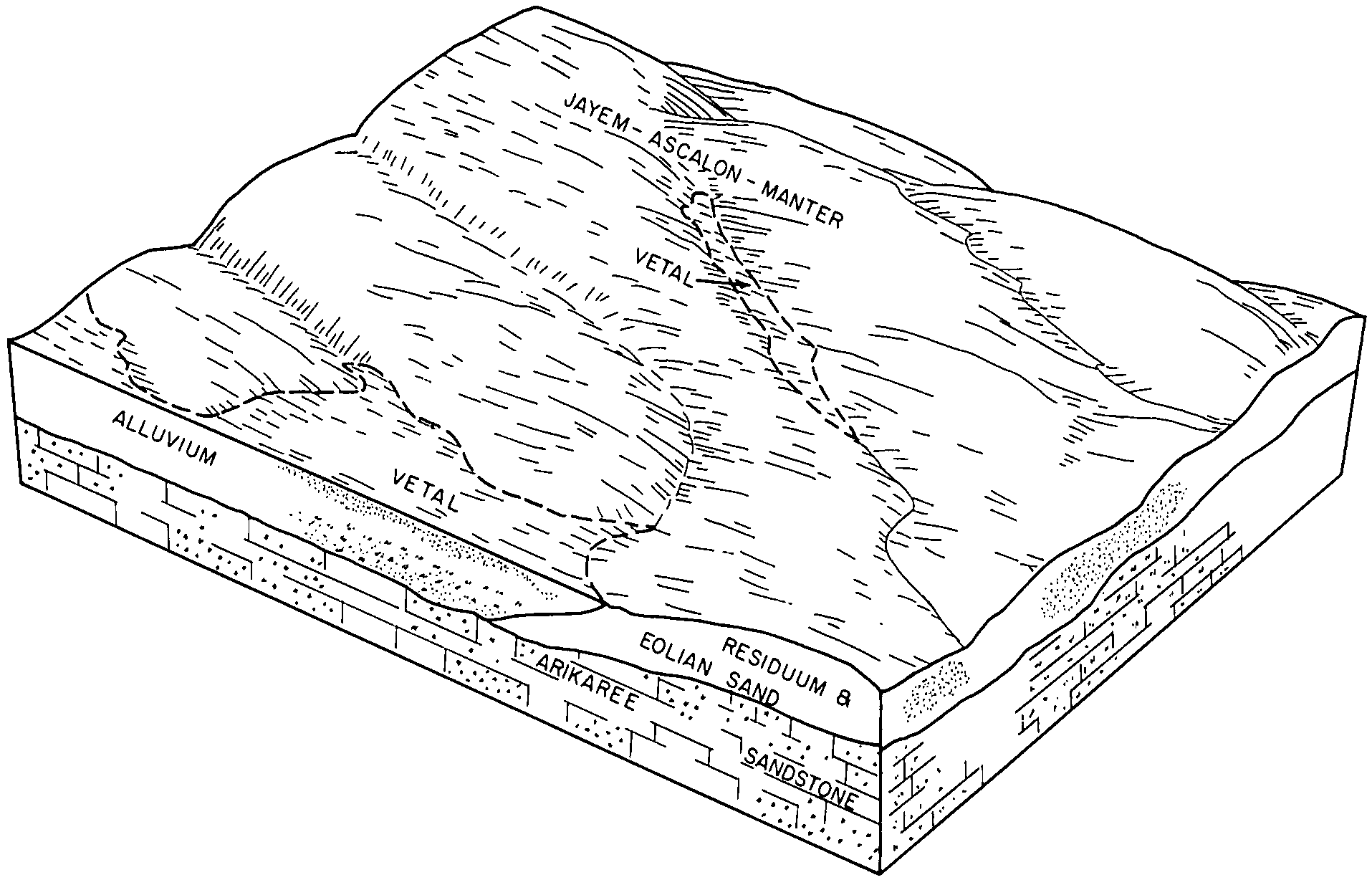
Jayem-Ascalon-Manter complex, 3 to 10 percent slopes | 15C | 54482 | 104856 | 3j3g | wy715 | 1974 | 1:20000 |
Jayem fine sandy loam, 3 to 10 percent slopes | 14C | 24805 | 104855 | 3j3f | wy715 | 1974 | 1:20000 |
Jayem fine sandy loam, 0 to 3 percent slopes | 14A | 15095 | 104854 | 2tvtr | wy715 | 1974 | 1:20000 |
Jayem loamy very fine sand, 0 to 3 percent slopes | 73 | 1411 | 1415359 | 2tvv9 | wy715 | 1974 | 1:20000 |
Jayem-Phiferson-Trelona fine sandy loams, 3 to 10 percent slopes | 63 | 869 | 1415164 | 2tvv6 | wy715 | 1974 | 1:20000 |
Jayem loamy very fine sand, 3 to 6 percent slopes | 78 | 566 | 1415363 | 2tvvb | wy715 | 1974 | 1:20000 |
Jayem loamy very fine sand, 6 to 9 percent slopes | 77 | 445 | 1415364 | 2tvvc | wy715 | 1974 | 1:20000 |
Jayem-Julesburg fine sandy loams, 6 to 15 percent slopes | 62 | 272 | 1415163 | 2tvv8 | wy715 | 1974 | 1:20000 |
Jayem-Julesburg fine sandy loams, 0 to 6 percent slopes | 61 | 248 | 1415162 | 2tvv7 | wy715 | 1974 | 1:20000 |
Jayem-Mainter-Moskee fine sandy loams, 0 to 6 percent slopes | 51 | 162 | 1414820 | 1jh7c | wy715 | 1974 | 1:20000 |