| Cliffdown-Izo families complex, 2 to 8 percent slopes | 25 | 105 | 615912 | nnx4 | az701 | 2001 | 1:24000 |
Bluewing-Izo complex, 5-15% slopes | 1002 | 681 | 3356321 | 2zzg5 | ca763 | 1984 | 1:24000 |
Stonell-Wardenot-Izo association | 482 | 323 | 3356315 | 312sl | ca763 | 1984 | 1:24000 |
Itme-Izo association | 126 | 11227 | 3271037 | j8lq | ca806 | | 1:24000 |
Bluewing-Izo complex, 5-15% slopes | 1002 | 8276 | 3271051 | 2zzg5 | ca806 | | 1:24000 |
Stonell-Wardenot-Izo association | 482 | 5335 | 3271063 | 312sl | ca806 | | 1:24000 |
Wardenot-Izo association | 442 | 2104 | 3271039 | 2s220 | ca806 | | 1:24000 |
Unsel-Izo complex | UT | 8761 | 3059654 | 2whn5 | nv622 | 1972 | 1:24000 |
Maggie-Pintwater-Izo association | MA | 6154 | 495597 | 2v417 | nv622 | 1972 | 1:24000 |
Izo-Misad association | 200 | 7820 | 479082 | j2j8 | nv768 | 1985 | 1:63360 |
Izo-Bubus association | 201 | 1602 | 479084 | j2jb | nv768 | 1985 | 1:63360 |
Unsel-Annnaw-Izo association | 1020 | 6016 | 476383 | 2s21z | nv770 | 1995 | 1:24000 |
Terlco-Annaw-Izo association | 1040 | 2709 | 476392 | 2s21y | nv770 | 1995 | 1:24000 |
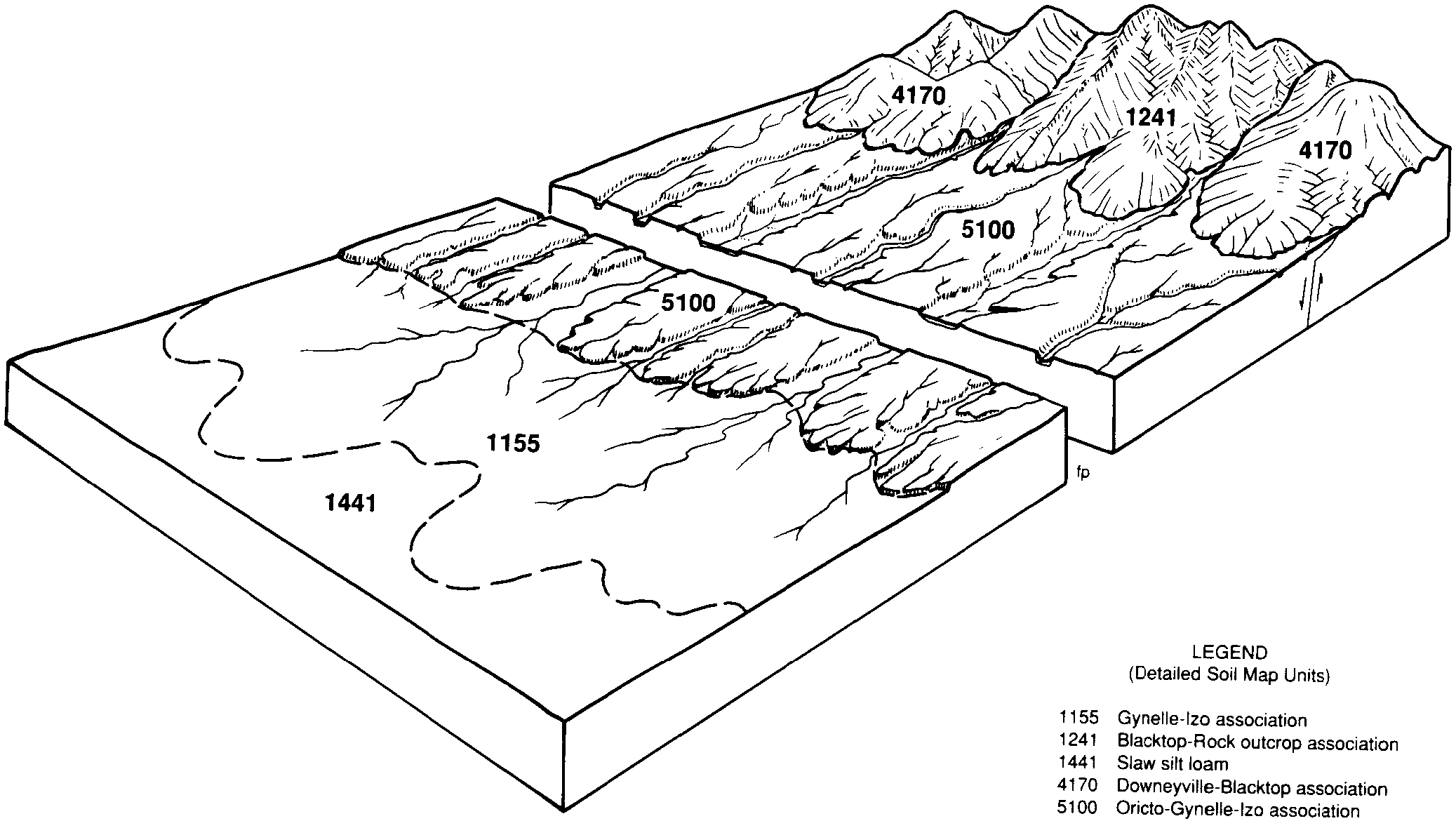
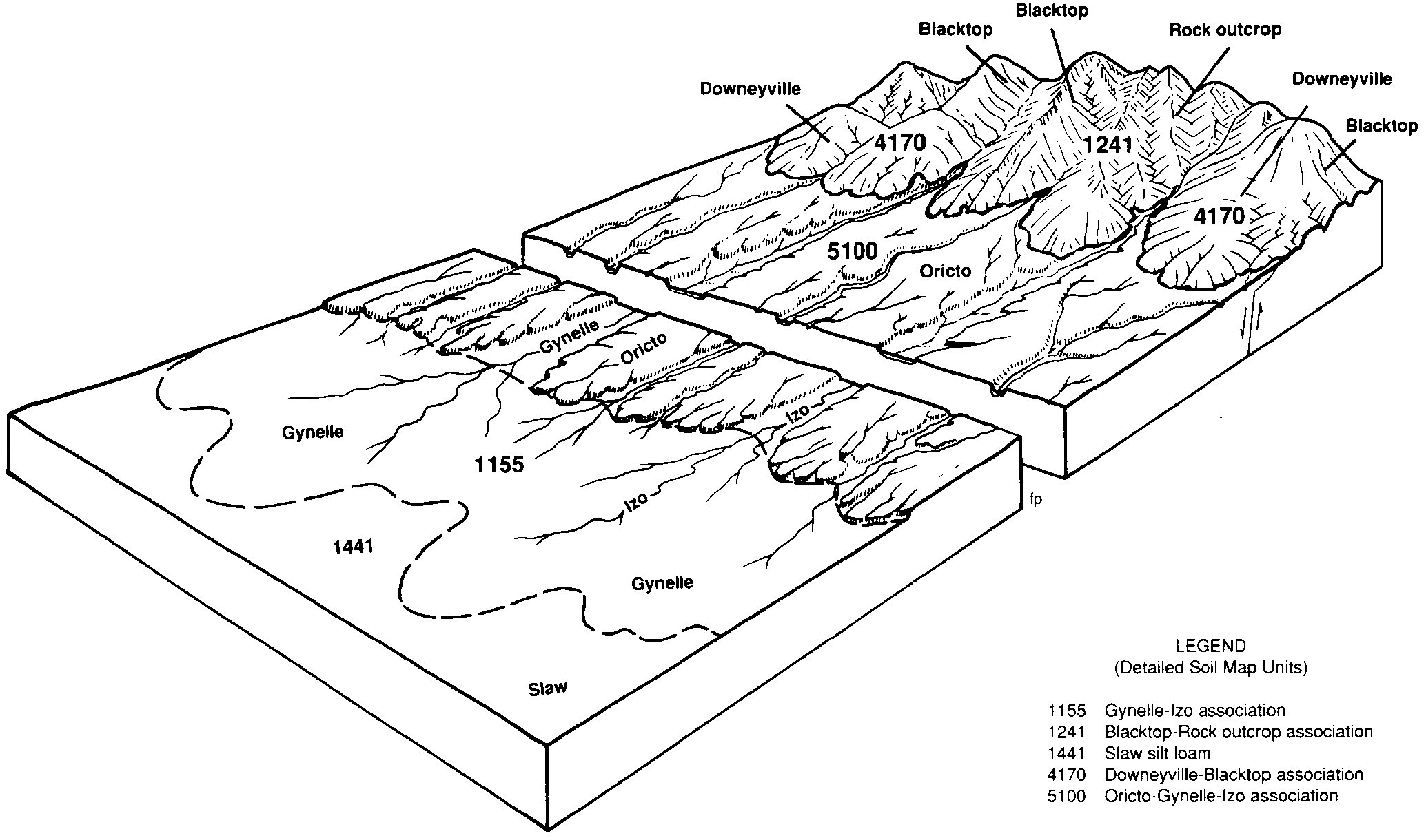
Luning-Izo association | 710 | 37 | 476652 | hzzw | nv770 | 1995 | 1:24000 |
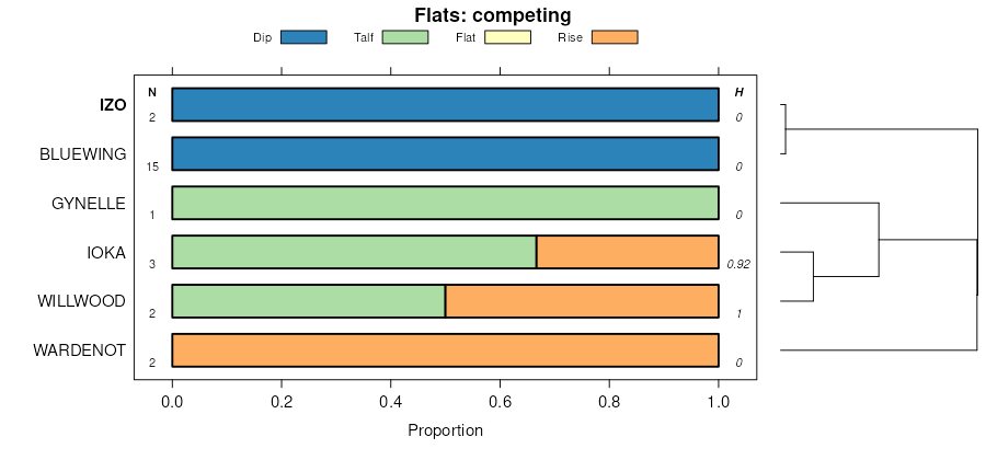
Oricto-Gynelle-Izo association | 5100 | 58233 | 476992 | 2xdmz | nv774 | 1985 | 1:24000 |
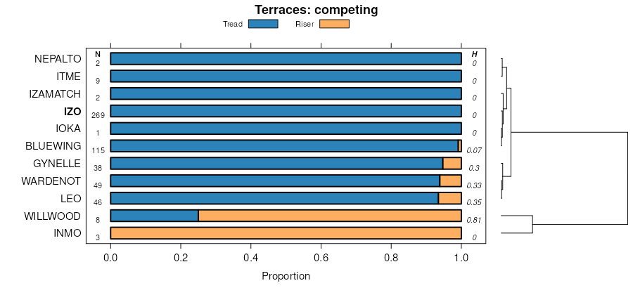
Gynelle-Izo association | 1155 | 43603 | 476724 | j026 | nv774 | 1985 | 1:24000 |
Candelaria-Wardenot-Izo association | 4181 | 27601 | 476962 | j09w | nv774 | 1985 | 1:24000 |
Wardenot-Truhoy-Izo association | 1894 | 17593 | 476830 | j05m | nv774 | 1985 | 1:24000 |
Unsel-Annnaw-Izo association | 1643 | 16679 | 476797 | 2s21z | nv774 | 1985 | 1:24000 |
Wardenot, moist-Izo association | 1892 | 16034 | 476828 | j05k | nv774 | 1985 | 1:24000 |
Izo, rarely flooded-Izo association | 1910 | 13963 | 476832 | j05p | nv774 | 1985 | 1:24000 |
Oricto-Izo association | 5101 | 12431 | 476993 | 2s23p | nv774 | 1985 | 1:24000 |
Candelaria-Izo association | 4180 | 11552 | 476961 | j09v | nv774 | 1985 | 1:24000 |
Terlco-Annaw-Izo association | 4162 | 11155 | 476949 | 2s21y | nv774 | 1985 | 1:24000 |
Candelaria-Gynelle-Izo association | 4182 | 10837 | 476963 | 2v42w | nv774 | 1985 | 1:24000 |
Wardenot-Izo association | 1891 | 10033 | 476827 | 2s220 | nv774 | 1985 | 1:24000 |
Luning-Izo association | 1877 | 8037 | 476823 | 2s23t | nv774 | 1985 | 1:24000 |
Belted-Izo association | 1323 | 6893 | 476752 | j033 | nv774 | 1985 | 1:24000 |
Belted-Terlco-Izo association | 1325 | 5294 | 476754 | j035 | nv774 | 1985 | 1:24000 |
Sodaspring-Izo association | 2002 | 5284 | 476845 | 2v41q | nv774 | 1985 | 1:24000 |
Terlco-Izo association, moderately steep | 4163 | 4727 | 476950 | j09h | nv774 | 1985 | 1:24000 |
Smedley-Annaw-Izo association | 3061 | 4560 | 476889 | j07j | nv774 | 1985 | 1:24000 |
Candelaria, dry-Izo association | 4184 | 4530 | 476965 | 2s22d | nv774 | 1985 | 1:24000 |
Wardenot-Annaw-Izo association, moist | 1893 | 4379 | 476829 | 2s22f | nv774 | 1985 | 1:24000 |
Wardenot, moderately steep-Wardenot-Izo association | 1890 | 3284 | 476826 | j05h | nv774 | 1985 | 1:24000 |
Candelaria-Izo, rarely flooded, association | 4183 | 2661 | 476964 | j09y | nv774 | 1985 | 1:24000 |
Fawin-Izo association | 1482 | 2552 | 476779 | j03z | nv774 | 1985 | 1:24000 |
Candelaria-Roic-Izo association | 4186 | 2524 | 476967 | j0b1 | nv774 | 1985 | 1:24000 |
Hawsley-Izo association | 1173 | 2096 | 476728 | j02b | nv774 | 1985 | 1:24000 |
Typic Torriorthents, 15 to 75 percent slopes | 1940 | 2029 | 476835 | j05s | nv774 | 1985 | 1:24000 |
Terlco-Izo association | 4161 | 2019 | 476948 | j09f | nv774 | 1985 | 1:24000 |
Wardenot-Stumble-Izo association | 1897 | 2014 | 476831 | j05n | nv774 | 1985 | 1:24000 |
Truhoy gravelly loamy sand, 2 to 8 percent slopes | 4062 | 1445 | 476927 | j08r | nv774 | 1985 | 1:24000 |
Lathrop-Terlco-Izo association | 1950 | 929 | 476836 | 2whm6 | nv774 | 1985 | 1:24000 |
Gynelle-Izo association, strongly sloping | 1156 | 892 | 476725 | j027 | nv774 | 1985 | 1:24000 |
Celeton-Dumps-Izo association | 6020 | 153 | 477002 | j0c5 | nv774 | 1985 | 1:24000 |
Unsel-Annnaw-Izo association | 1142 | 15899 | 480694 | 2s21z | nv781 | 1994 | 1:24000 |
Unsel-Wardenot-Izo association | 1141 | 11112 | 480693 | 2s239 | nv781 | 1994 | 1:24000 |
Unsel-Silverbow-Izo association | 1146 | 3346 | 480697 | j46c | nv781 | 1994 | 1:24000 |
Oricto-Izo association | 1291 | 2815 | 480726 | 2s23p | nv781 | 1994 | 1:24000 |
Stonell-Wardenot-Izo association | 1930 | 2504 | 480833 | 2s21x | nv781 | 1994 | 1:24000 |
Luning-Izo association | 2111 | 2429 | 480846 | 2s23t | nv781 | 1994 | 1:24000 |
Terlco-Annaw-Izo association | 1323 | 1625 | 480735 | 2s21y | nv781 | 1994 | 1:24000 |
Maggie-Pintwater-Izo association | 2080 | 1475 | 480842 | 2v417 | nv781 | 1994 | 1:24000 |
Leo-Izo association | 1704 | 1058 | 480804 | j49t | nv781 | 1994 | 1:24000 |
Izo very gravelly sand, 2 to 8 percent slopes | 1820 | 607 | 480817 | j4b7 | nv781 | 1994 | 1:24000 |
Pintwater-Izo association | 1950 | 93 | 480834 | j4bs | nv781 | 1994 | 1:24000 |
Unsel-Izo association | 3139 | 2885 | 480916 | 2s23d | nv783 | 1991 | 1:24000 |
Lidan-Izo association | 2540 | 5958 | 469178 | hr6s | nv785 | 1995 | 1:24000 |
Ardivey-Stonell-Izo association | 2671 | 5754 | 469191 | hr76 | nv785 | 1995 | 1:24000 |
Stonell-Wardenot-Izo association | 2660 | 3918 | 469189 | 2s21x | nv785 | 1995 | 1:24000 |
Luning-Wardenot-Izo association | 2650 | 2730 | 469188 | hr73 | nv785 | 1995 | 1:24000 |
Vigus-Fuegosta-Izo association | 2520 | 2424 | 469174 | hr6n | nv785 | 1995 | 1:24000 |
Stonewall-Izo-Lidan association | 2550 | 1892 | 469179 | hr6t | nv785 | 1995 | 1:24000 |
Ardivey-Izo association | 2670 | 1433 | 469190 | 2s22r | nv785 | 1995 | 1:24000 |
Wardenot-Izo association | 2580 | 1336 | 469181 | 2s220 | nv785 | 1995 | 1:24000 |
Leo-Izo association | 2690 | 1269 | 469195 | hr7b | nv785 | 1995 | 1:24000 |
Fuegosta-Tomel-Izo association | 2510 | 818 | 469172 | hr6l | nv785 | 1995 | 1:24000 |
Fuegosta-Wardenot-Izo association | 2511 | 564 | 469173 | hr6m | nv785 | 1995 | 1:24000 |
Silverbow-Wardenot-Izo association | 2750 | 457 | 469207 | hr7q | nv785 | 1995 | 1:24000 |
Unsel-Wardenot-Izo association | 101 | 95413 | 484883 | 2s239 | nv796 | 1984 | 1:63360 |
Stonell-Wardenot-Izo association, moist | 480 | 34608 | 485065 | j8r8 | nv796 | 1984 | 1:63360 |
Unsel-Izo association | 108 | 24271 | 484899 | 2s23d | nv796 | 1984 | 1:63360 |
Wardenot-Izo association | 442 | 18489 | 485043 | 2s220 | nv796 | 1984 | 1:63360 |
Stonell-Wardenot-Izo association | 482 | 13653 | 485067 | 2s21x | nv796 | 1984 | 1:63360 |
Wardenot-Annaw-Izo association | 446 | 12799 | 485047 | j8qp | nv796 | 1984 | 1:63360 |
Itme-Izo association | 126 | 11480 | 484924 | j8lq | nv796 | 1984 | 1:63360 |
Ardivey-Wardenot-Izo association | 476 | 10850 | 485063 | j8r6 | nv796 | 1984 | 1:63360 |
Lyda-Ardivey-Izo association | 780 | 10000 | 485145 | j8tv | nv796 | 1984 | 1:63360 |
Silverbow-Wardenot-Izo association | 510 | 9834 | 485073 | 2v41p | nv796 | 1984 | 1:63360 |
Yomba-Wardenot-Izo association | 161 | 8361 | 484936 | j8m3 | nv796 | 1984 | 1:63360 |
Fuegosta-Tomel-Izo association | 920 | 6462 | 485172 | j8vq | nv796 | 1984 | 1:63360 |
Sodaspring-Izo association | 990 | 6236 | 485183 | 2v41q | nv796 | 1984 | 1:63360 |
Wardenot-Annaw-Izo association, moist | 447 | 5591 | 485048 | 2s22f | nv796 | 1984 | 1:63360 |
Papoose-Izo association | 1034 | 5355 | 484892 | j8kp | nv796 | 1984 | 1:63360 |
Ardivey-Tomel-Izo association | 475 | 4826 | 485062 | j8r5 | nv796 | 1984 | 1:63360 |
Lathrop-Terlco-Izo association | 273 | 4616 | 484976 | 2whm6 | nv796 | 1984 | 1:63360 |
Ardivey-Izo association | 471 | 4010 | 485059 | 2s22r | nv796 | 1984 | 1:63360 |
Unsel-Silverbow-Izo association | 103 | 4010 | 484887 | j8kj | nv796 | 1984 | 1:63360 |
Noyson-Stumble-Izo association | 390 | 3562 | 485027 | j8q1 | nv796 | 1984 | 1:63360 |
Candelaria, dry-Izo association | 334 | 2591 | 485002 | 2s22d | nv796 | 1984 | 1:63360 |
Leo-Izo association | 122 | 1931 | 484922 | j8ln | nv796 | 1984 | 1:63360 |
Vigus-Fuegosta-Izo association | 421 | 1878 | 485036 | 2v426 | nv796 | 1984 | 1:63360 |
Candelaria-Gynelle-Izo association | 331 | 1693 | 485001 | 2v42w | nv796 | 1984 | 1:63360 |
Stumble-Belcher-Izo association | 141 | 1363 | 484930 | j8lx | nv796 | 1984 | 1:63360 |
Vigus-Unsel-Izo association | 420 | 562 | 485035 | j8q9 | nv796 | 1984 | 1:63360 |
Celeton-Dumps-Izo association | 520 | 457 | 485075 | j8rl | nv796 | 1984 | 1:63360 |
Oricto-Gynelle-Izo association | 170 | 1423 | 477609 | 2xdmz | nv799 | 1991 | 1:24000 |
Izo very gravelly sand, 2 to 4 percent slopes | 110 | 290 | 477600 | j0zg | nv799 | 1991 | 1:24000 |