| Iuka silt loam | Iu | 16758 | 328151 | c0gj | al003 | 1961 | 1:20000 |
Local alluvial land | Lv | 4285 | 328165 | c0gz | al003 | 1961 | 1:20000 |
Iuka-Bibb complex, 0 to 1 percent slopes, frequently flooded | IbA | 35200 | 328266 | c0l7 | al005 | 2001 | 1:24000 |
Mantachie, Kinston and Iuka soils, 0 to 1 percent slopes, frequently flooded | MAA | 31540 | 328260 | 2s69d | al005 | 2001 | 1:24000 |
Bibb-Iuka complex, 0 to 1 percent slopes, frequently flooded | BdA | 23160 | 2230311 | 2shs8 | al007 | 2007 | 1:24000 |
Mantachie, Kinston and Iuka soils, 0 to 1 percent slopes, frequently flooded | MIA | 20625 | 2232533 | 2s69d | al007 | 2007 | 1:24000 |
Mantachie, Iuka, and Bibb soils, 0 to 1 percent slopes, frequently flooded | MBA | 43870 | 328423 | c0r9 | al011 | 1986 | 1:20000 |
Mantachie, Bibb, and Iuka soils, 0 to 1 percent slopes, frequently flooded | MIA | 56120 | 328464 | c0sm | al013 | 1996 | 1:20000 |
Bibb-Iuka complex, 0 to 1 percent slopes, frequently flooded | BbA | 37400 | 328593 | 2shs8 | al023 | 1998 | 1:24000 |
Ochlockonee, Kinston, and Iuka soils, 0 to 1 percent slopes, frequently flooded | OKA | 26540 | 328569 | c0x0 | al023 | 1998 | 1:24000 |
Iuka, Bibb, and Mantachie soils, 0 to 1 percent slopes, frequently flooded | IBA | 57350 | 328641 | c0zb | al025 | 2004 | 1:24000 |
Iuka-Bibb sandy loams, 0 to 2 percent slopes, frequently flooded | IbA | 6479 | 328766 | c13c | al039 | 1985 | 1:20000 |
Mantachie, Kinston and Iuka soils, 0 to 1 percent slopes, frequently flooded | MKA | 29350 | 328874 | 2s69d | al041 | 2005 | 1:24000 |
Bibb-Iuka complex, 0 to 1 percent slopes, frequently flooded | BbA | 24630 | 581611 | 2shs8 | al041 | 2005 | 1:24000 |
Iuka-Marietta complex, 0 to 2 percent slopes, frequently flooded | ImA | 860 | 1532998 | 1ng6k | al041 | 2005 | 1:24000 |
Iuka soils, local alluvium | Ib | 367 | 328984 | c1bd | al045 | 1958 | 1:20000 |
Iuka fine sandy loam | Ia | 128 | 328983 | c1bc | al045 | 1958 | 1:20000 |
Mantachie, Kinston and Iuka soils, 0 to 1 percent slopes, frequently flooded | MKA | | 2965322 | 2s69d | al051 | 1948 | 1:20000 |
Iuka silt loam | Ik | 2686 | 329464 | c1tw | al057 | 1963 | 1:15840 |
Iuka-Ochlockonee complex, local alluvium | Io | 1795 | 329465 | c1tx | al057 | 1963 | 1:15840 |
Iuka fine sandy loam, 0 to 2 percent slopes, occasionally flooded | Is | 6788 | 329570 | 2w6ff | al059 | 1962 | 1:15840 |
Iuka fine sandy loam, local alluvium | Iu | 806 | 329571 | c1yb | al059 | 1962 | 1:15840 |
Mantachie, Kinston and Iuka soils, 0 to 1 percent slopes, frequently flooded | MIA | 21825 | 329771 | 2s69d | al065 | 2003 | 1:24000 |
Bibb-Iuka complex, 0 to 1 percent slopes, frequently flooded | BdA | 15656 | 329743 | 2shs8 | al065 | 2003 | 1:24000 |
Mantachie, Iuka, and Kinston soils, 0 to 1 percent slopes, frequently flooded | MIA | 4580 | 640568 | phkh | al069 | 2002 | 1:24000 |
Iuka-Mantachie complex, 0 to 2 percent slopes, frequently flooded | ImA | 7920 | 2494543 | 2vxx1 | al075 | 2010 | 1:24000 |
Mantachie, Kinston and Iuka soils, 0 to 1 percent slopes, frequently flooded | MKI | 7207 | 2514613 | 2s69d | al085 | 2011 | 1:24000 |
Iuka-Marietta complex, 0 to 2 percent slopes, frequently flooded | ImA | 2768 | 2514650 | 2qcwk | al085 | 2011 | 1:24000 |
Bibb-Iuka complex, 0 to 1 percent slopes, frequently flooded | BbA | 15790 | 330558 | 2shs8 | al091 | 1997 | 1:24000 |
Iuka-Mantachie complex, 0 to 2 percent slopes, frequently flooded | 11 | 26000 | 330612 | 2vxx1 | al093 | 1976 | 1:20000 |
Mantachie-Iuka association | 17 | 6250 | 330618 | c313 | al093 | 1976 | 1:20000 |
Iuka and Mantachie soils, 0 to 2 percent slopes, frequently flooded | ImA | 51300 | 330840 | c388 | al099 | 1984 | 1:20000 |
Mantachie, Kinston and Iuka soils, 0 to 1 percent slopes, frequently flooded | MKA | 21571 | 330954 | 2s69d | al101 | 1958 | 1:20000 |
Iuka soils, local alluvium phases | Ic | 1124 | 330916 | c3bq | al101 | 1958 | 1:20000 |
Iuka soils | Ib | 317 | 330915 | c3bp | al101 | 1958 | 1:20000 |
Mantachie, Kinston and Iuka soils, 0 to 1 percent slopes, frequently flooded | MIA | 29790 | 331240 | 2s69d | al105 | 1996 | 1:24000 |
Ochlockonee-Kinston-Iuka complex, 0 to 2 percent slopes, frequently flooded | OcA | 5480 | 331269 | c3q3 | al107 | 1997 | 1:24000 |
Mantachie, Kinston and Iuka soils, 0 to 1 percent slopes, frequently flooded | MAA | 65430 | 331318 | 2s69d | al109 | 1996 | 1:20000 |
Kinston, Mantachie, and Iuka soils, 0 to 1 percent slopes, frequently flooded | KMA | 40230 | 331344 | c3sj | al113 | 1997 | 1:24000 |
Kinston-Iuka complex, 0 to 1 percent slopes, frequently flooded | KnA | 1300 | 1476420 | 1lkbg | al123 | 2005 | 1:24000 |
Iuka-Mantachie complex, 0 to 2 percent slopes, frequently flooded | 19 | 36816 | 331511 | 2vxx1 | al125 | 1980 | 1:20000 |
Bibb-Iuka complex, 0 to 2 percent slopes, frequently flooded | BiA | 9333 | 2642056 | 2rjqt | al129 | 2013 | 1:24000 |
Iuka-Mantachie silt loams (ouachita, guyton) | IM | 5612 | 565154 | lz2s | ar011 | 1959 | 1:20000 |
Iuka fine sandy loam, occasionally flooded | 29 | 4248 | 3179361 | lymp | ar019 | 1983 | 1:20000 |
Iuka soils, local alluvium, 3 to 8 percent slopes (beulah) | IvC | 1190 | 564402 | ly9j | ar037 | 1966 | 1:20000 |
Iuka loam, 0 to 1 percent slopes | IuA | 1020 | 564399 | ly9f | ar037 | 1966 | 1:20000 |
Iuka soils, local alluvium, 1 to 3 percent slopes | IvB | 450 | 564401 | ly9h | ar037 | 1966 | 1:20000 |
Iuka loam, gently undulating | IuB | 290 | 564400 | ly9g | ar037 | 1966 | 1:20000 |
Bruno and Iuka soils | Bu | 9433 | 565532 | lzgz | ar047 | 1967 | 1:20000 |
Iuka fine sandy loam, occasionally flooded | 29 | 402 | 3179251 | lymp | ar059 | 1983 | 1:20000 |
Iuka soils | Ik | 600 | 564457 | lyc9 | ar123 | 1964 | 1:20000 |
Iuka sandy loam | Ik | 273 | 128613 | 49tt | dc001 | 1975 | 1:12000 |
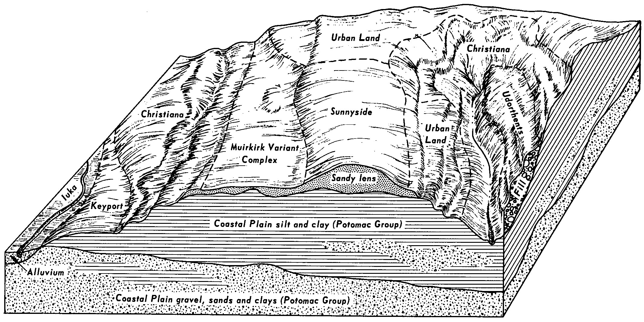
Iuka-Urban land complex | Ip | 253 | 128614 | 49tv | dc001 | 1975 | 1:12000 |
Iuka fine sandy loam, frequently flooded | 71 | 900 | 1425376 | 1jv6w | fl033 | 1998 | 1:24000 |
Iuka loam | 37 | 970 | 1424941 | 1jtrv | fl063 | 1977 | 1:20000 |
Ochlockonee, Iuka, and Bibb soils, 0 to 5 percent slopes, frequently flooded | OBB | 6330 | 2425397 | 2mdtm | ga259 | 2009 | 1:12000 |
Ochlockonee, Iuka, and Bibb soils, 0 to 5 percent slopes, frequently flooded | OBB | 1030 | 2455427 | 2nf2b | ga307 | 2009 | 1:12000 |
Iuka sandy loam, occasionally flooded | Iu | 9476 | 126186 | 479j | ga620 | 1992 | 1:20000 |
Collins-Iuka complex, occasionally flooded | Cu | 7111 | 570625 | m4s8 | ky083 | 1995 | 1:12000 |
Collins-Iuka complex, 0 to 4 percent slopes, rarely flooded | Co | 870 | 1597332 | 1qm4v | ky602 | 1972 | 1:12000 |
Collins-Iuka complex, 0 to 2 percent slopes, occasionally flooded | Cu | 14890 | 2232232 | 2dxth | ky610 | 1968 | 1:12000 |
Collins-Iuka complex, 0 to 2 percent slopes, frequently flooded | Ci | 8074 | 2232333 | 2dxxr | ky610 | 1968 | 1:12000 |
Iuka sandy loam, occasionally flooded | Iu | 662 | 570526 | m4p2 | ky611 | 1991 | 1:20000 |
Iuka-Mantachie complex, frequently flooded | IUA | 6062 | 1725711 | 1vxr3 | la011 | 1993 | 1:24000 |
Iuka fine sandy loam, 0 to 1 percent slopes, frequently flooded | IB | 1411 | 1725653 | 2ynxs | la021 | 1985 | 1:24000 |
Iuka-Dela complex, 0 to 1 percent slopes, frequently flooded | Io | 27435 | 569324 | 2ynxt | la027 | 1986 | 1:20000 |
Iuka and Ochlockonee soils, frequently flooded | IU | 14784 | 1724541 | 1vwjc | la031 | 1986 | 1:24000 |
Iuka-Dela complex, 0 to 1 percent slopes, frequently flooded | IUA | 44052 | 571123 | 2ynxt | la061 | 1991 | 1:24000 |
Guyton-Iuka association, frequently flooded | GYA | 76803 | 1903031 | 21w83 | la085 | 1991 | 1:24000 |
Iuka-Dela complex, 0 to 1 percent slopes, frequently flooded | ID | 39532 | 1725344 | 2ynxt | la111 | 1992 | 1:24000 |
Iuka-Dela complex, 0 to 1 percent slopes, frequently flooded | IU | 4798 | 570352 | 2ynxt | la119 | 1989 | 1:24000 |
Mantachie, Bibb, and Iuka soils (kirkville, kinston, iuka) | Mn | 31002 | 332011 | c4h1 | ms023 | 1963 | 1:15840 |
Bibb-Iuka complex, 0 to 2 percent slopes, frequently flooded | BiA | 18110 | 2642163 | 2rrxq | ms041 | 2012 | 1:24000 |
Collins and Iuka soils | Cs | 4139 | 568147 | m26b | ms085 | 1961 | 1:20000 |
Iuka soils | Iu | 780 | 333178 | c5pp | ms095 | 1963 | 1:15840 |
Iuka fine sandy loam | Iu | 1804 | 333246 | c5rw | ms097 | 1971 | 1:20000 |
Iuka and Ochlockonee soils | Io | 4820 | 333644 | c65q | ms113 | 1965 | 1:15840 |
Iuka and Ochlockonee soils | Io | 2563 | 333699 | c67h | ms115 | 1969 | 1:20000 |
Iuka fine sandy loam, 0 to 2 percent slopes, occasionally flooded | Iu | 9147 | 333804 | 2w6ff | ms117 | 1995 | 1:24000 |
Bibb and Iuka sandy loams, frequently flooded | BI | 2601 | 333796 | c6bm | ms117 | 1995 | 1:24000 |
Iuka soils | Ik | 1608 | 334198 | c6rl | ms139 | 1963 | 1:15840 |
Iuka soils, local alluvium | Iu | 541 | 334199 | c6rm | ms139 | 1963 | 1:15840 |
Ochlockonee-iuka soils, (jena-kirkville) | Oc | 9103 | 334287 | c6vg | ms147 | 1965 | 1:20000 |
Bibb-Iuka complex, 0 to 1 percent slopes, frequently flooded | BkA | 39096 | 2403430 | 2shs8 | ms153 | 2008 | 1:24000 |
Iuka loam, 0 to 2 percent slopes, occasionally flooded | Ik | 10081 | 2545349 | 2qsg9 | tn005 | 2011 | 1:12000 |
Iuka silt loam, occasionally flooded | Iu | 7282 | 327218 | bzhf | tn023 | 1989 | 1:24000 |
Iuka fine sandy loam, 0 to 2 percent slopes, occasionally flooded | Ek | 3471 | 327305 | 2w6ff | tn039 | 2008 | 1:24000 |
Iuka silt loam, occasionally flooded | Iu | 13505 | 327468 | bzrh | tn069 | 1996 | 1:24000 |
Collins loam, local alluvium (Iuka) | Cg | 5378 | 327535 | bztn | tn071 | 1961 | 1:15840 |
Collins fine sandy loam (Iuka) | Cf | 1496 | 327534 | bztm | tn071 | 1961 | 1:15840 |
Collins silt loam (Iuka) | Ch | 1487 | 327536 | bztp | tn071 | 1961 | 1:15840 |
Hymon fine sandy loam, local alluvium phase (Iuka) | Hc | 5435 | 327748 | c01j | tn077 | 1955 | 1:20000 |
Hymon fine sandy loam (Iuka) | Hb | 593 | 327747 | c01h | tn077 | 1955 | 1:20000 |
Iuka loam, 0 to 2 percent slopes, occasionally flooded | Ik | 10322 | 2545264 | 2qs88 | tn079 | 2012 | 1:12000 |
Iuka fine sandy loam, 0 to 2 percent slopes, occasionally flooded | Iu | 23902 | 327961 | 2w6ff | tn109 | 1994 | 1:20000 |
Iuka fine sandy loam | Iu | 6356 | 567204 | m16x | tn113 | 1974 | 1:20000 |
Iuka soils, frequently flooded | Iu | 26096 | 374425 | dkm7 | tx611 | 1980 | 1:20000 |
Iuka fine sandy loam, local alluvium, 0 to 4 percent slopes | Iu | 280 | 2453569 | 2nc4d | va153 | 1985 | 1:15840 |
Iuka fine sandy loam, local alluvium, 0 to 4 percent slopes | Iu | 3072 | 120528 | 41f0 | va179 | 1970 | 1:15840 |