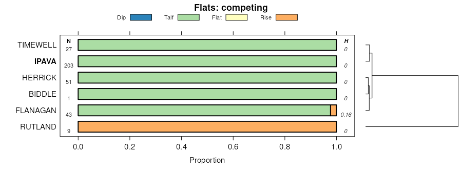
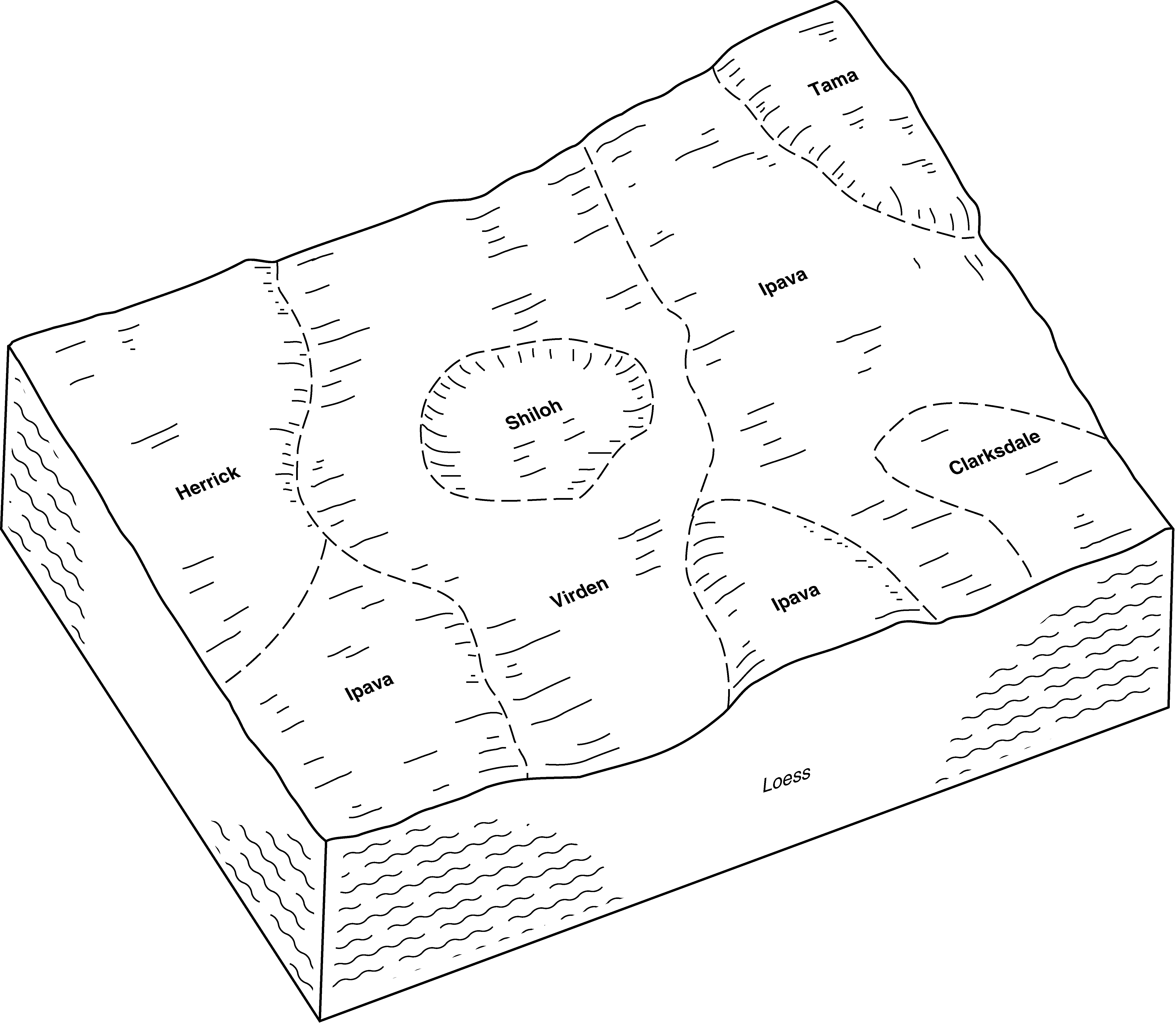
| Timewell and Ipava soils, 0 to 2 percent slopes | 855A | 36414 | 2378665 | 2rmnr | il001 | 1997 | 1:12000 |
Timewell and Ipava soils, 2 to 5 percent slopes | 855B | 11202 | 2378666 | 2rmns | il001 | 1997 | 1:12000 |
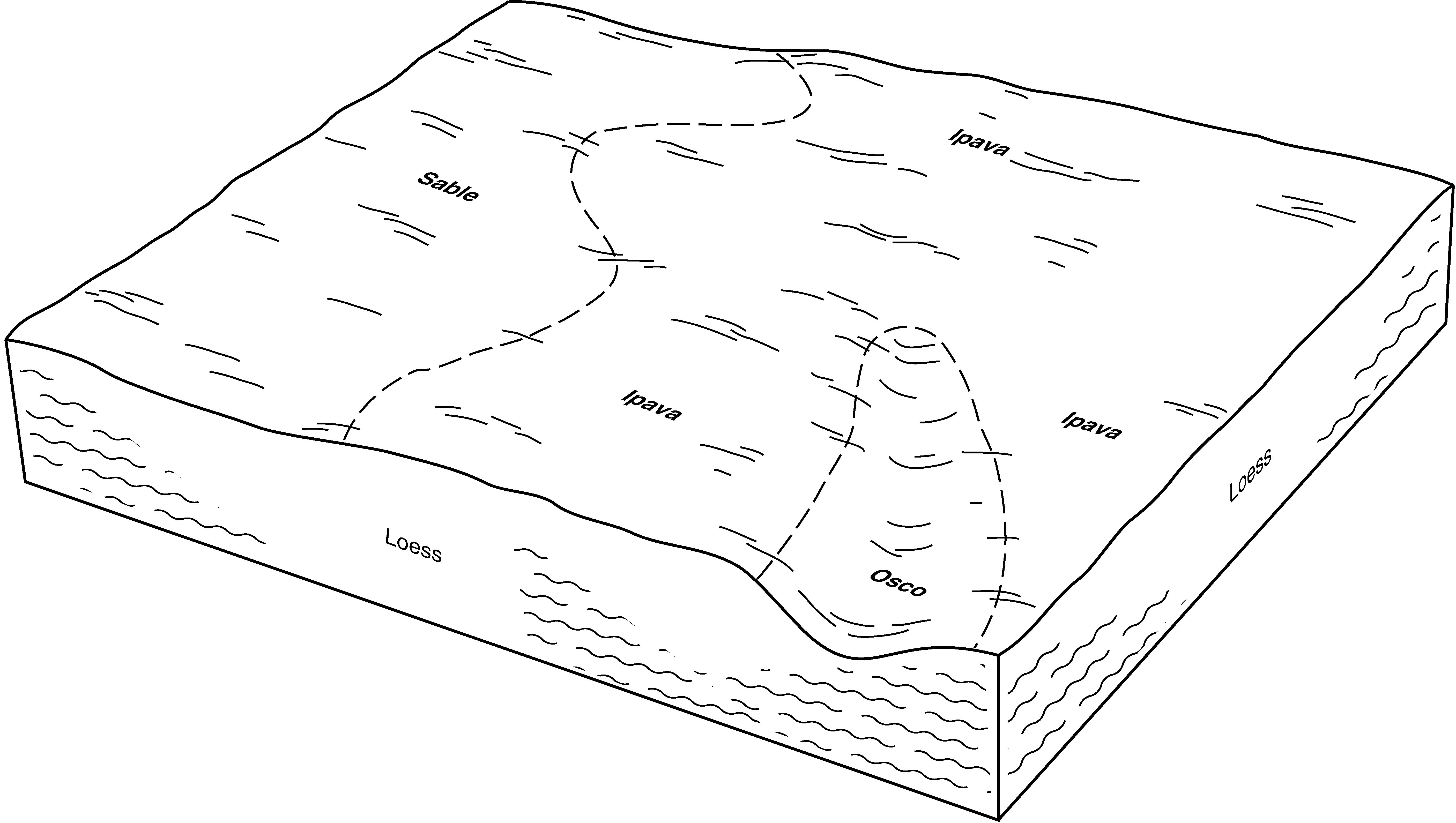
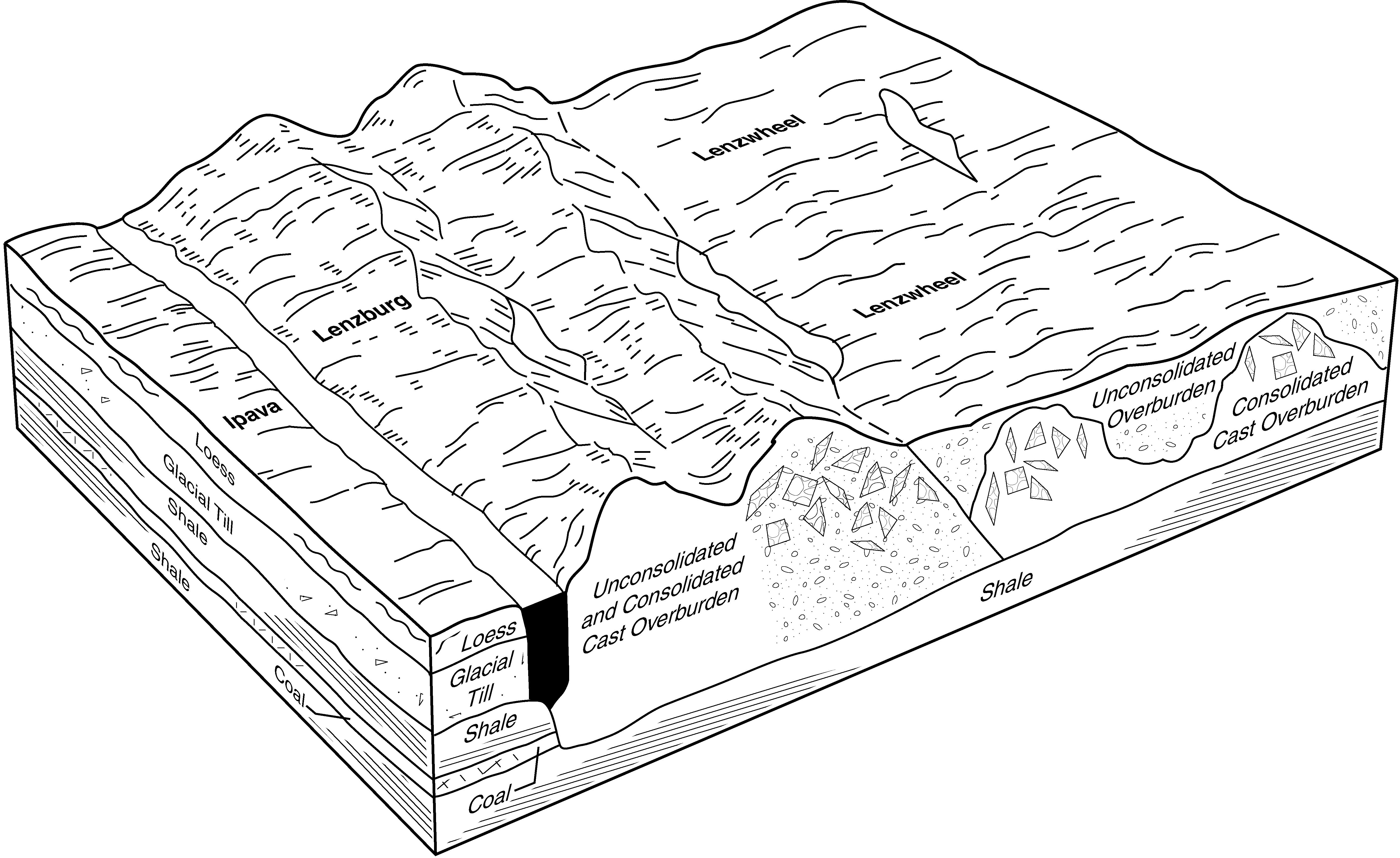
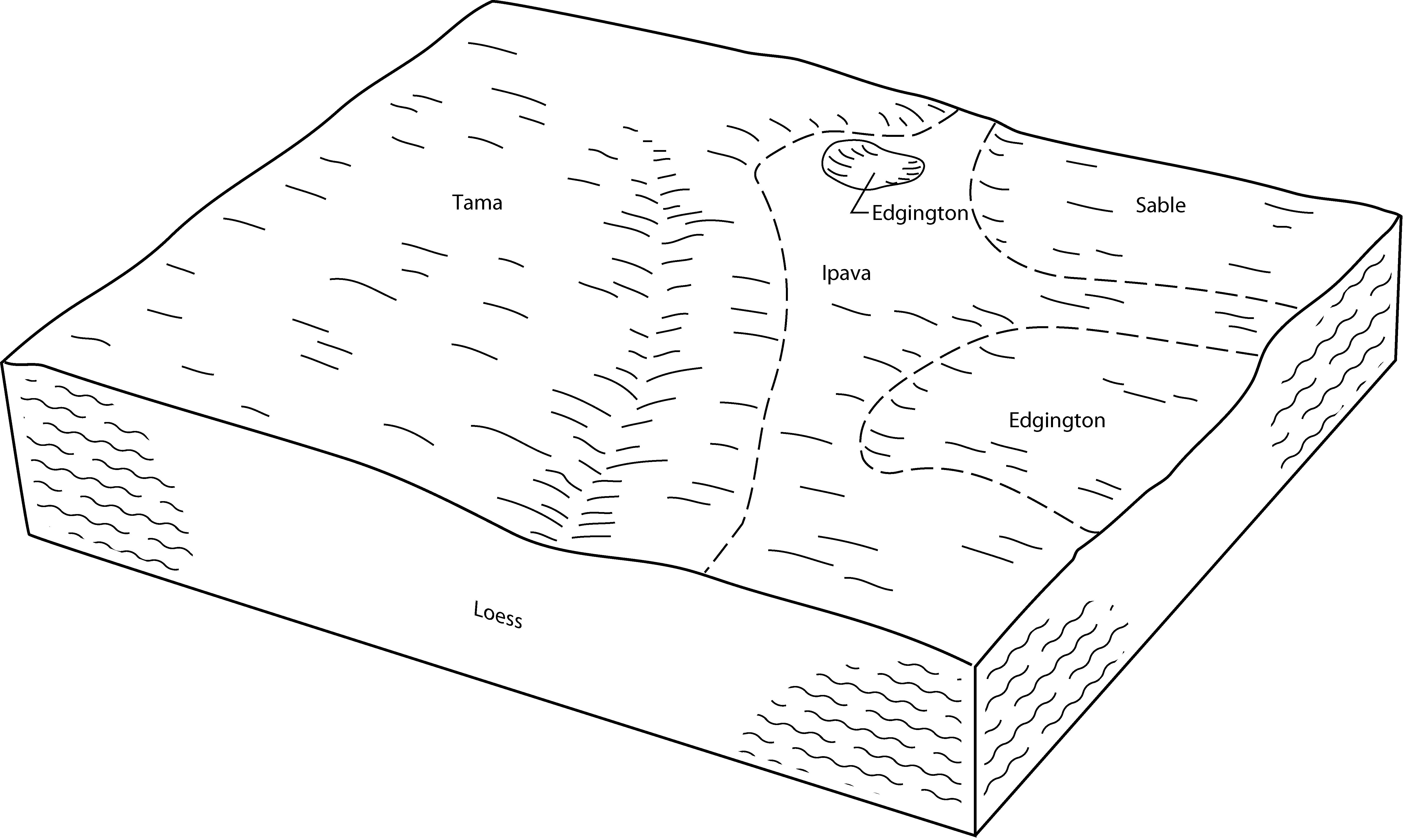
Ipava silt loam, 0 to 2 percent slopes | 43A | 5437 | 172981 | 2rmnj | il009 | 1984 | 1:12000 |
Timewell and Ipava soils, 0 to 2 percent slopes | 855A | 2460 | 172984 | 2rmnr | il009 | 1984 | 1:12000 |
Ipava silt loam, 2 to 5 percent slopes | 43B | 1571 | 172982 | 2rmnk | il009 | 1984 | 1:12000 |
Ipava silt loam, 0 to 2 percent slopes | 43A | 19709 | 262783 | 2rmnj | il017 | 2003 | 1:12000 |
Ipava silt loam, 0 to 2 percent slopes | 43A | 55971 | 261750 | 2rmnj | il021 | 1999 | 1:12000 |
Ipava silt loam, 0 to 2 percent slopes | 43A | 40542 | 1529518 | 2rmnj | il039 | 2005 | 1:12000 |
Ipava silt loam, 0 to 2 percent slopes | 43A | 45479 | 615626 | 2rmnj | il057 | 1997 | 1:12000 |
Ipava silt loam, 0 to 2 percent slopes | 43A | 1137 | 211765 | 2rmnj | il061 | 1968 | 1:15840 |
Ipava silt loam, 0 to 2 percent slopes | 43A | 46531 | 175197 | 2rmnj | il067 | 1993 | 1:15840 |
Ipava silt loam, 2 to 5 percent slopes, eroded | 43B2 | 24965 | 175199 | 2rmnl | il067 | 1993 | 1:15840 |
Timewell and Ipava soils, 0 to 2 percent slopes | 855A | 628 | 2604117 | 2rmnr | il067 | 1993 | 1:15840 |
Ipava silt loam, terrace, 0 to 2 percent slopes | 9043A | 291 | 2604118 | 2rmnm | il067 | 1993 | 1:15840 |
Ipava silt loam, 2 to 5 percent slopes | 43B | 149 | 175198 | 2rmnk | il067 | 1993 | 1:15840 |
Timewell and Ipava soils, 2 to 5 percent slopes | 855B | 21 | 2604119 | 2rmns | il067 | 1993 | 1:15840 |
Ipava silt loam, 0 to 2 percent slopes | 43A | 29826 | 244629 | 2rmnj | il073 | 2001 | 1:12000 |
Ipava silt loam, 0 to 2 percent slopes | 43A | 75458 | 680866 | 2rmnj | il095 | 2002 | 1:12000 |
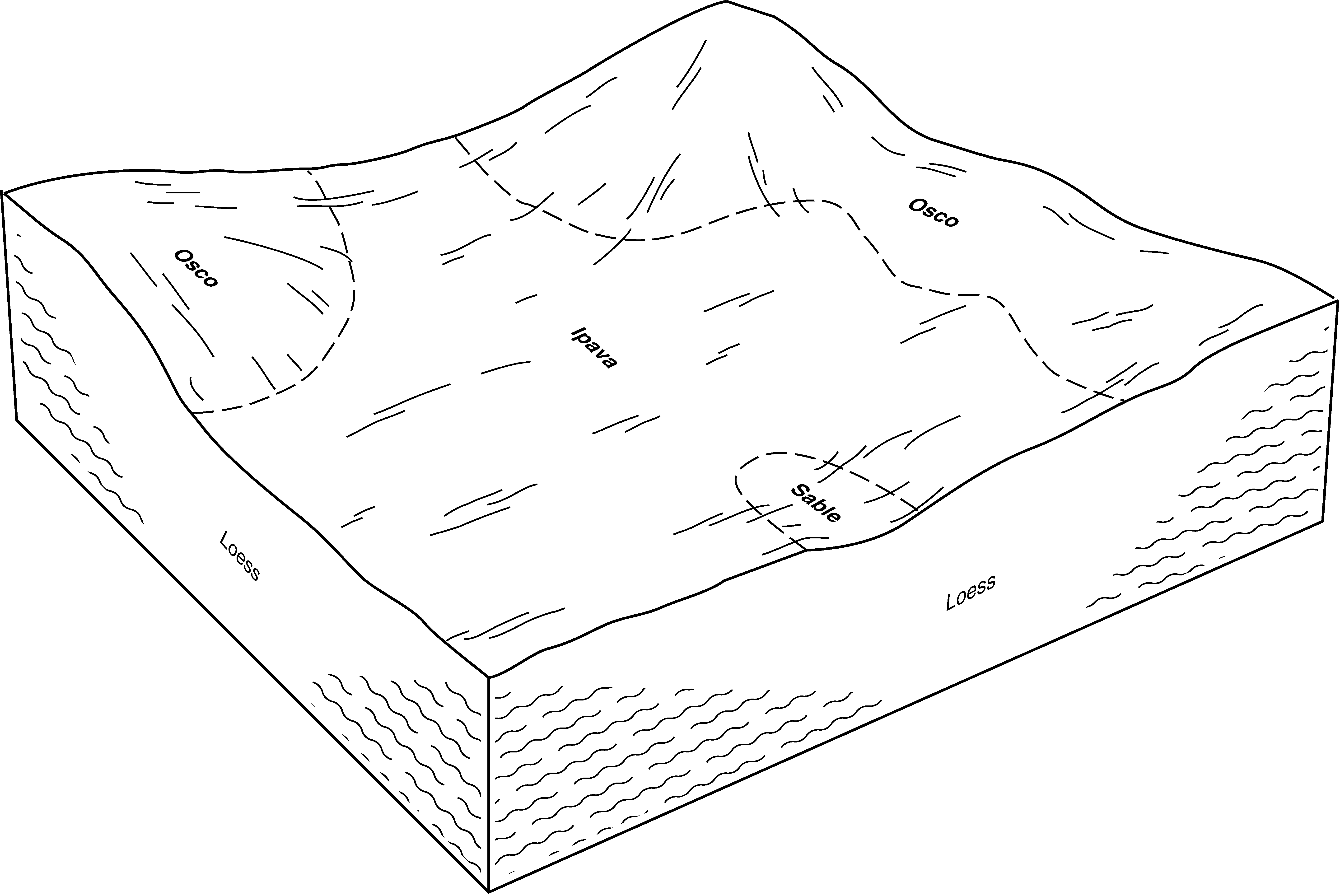
Ipava-Sable complex, 0 to 2 percent slopes | 902A | 2513 | 681036 | 2tjpn | il095 | 2002 | 1:12000 |
Ipava-Osco silt loams, 2 to 5 percent slopes | 901B | 1388 | 681035 | 2tjp0 | il095 | 2002 | 1:12000 |
Ipava silt loam, 0 to 2 percent slopes | 43A | 77689 | 1595752 | 2rmnj | il107 | 2006 | 1:12000 |
Ipava silt loam, 0 to 2 percent slopes | 43A | 88026 | 634188 | 2rmnj | il109 | 2002 | 1:12000 |
Ipava silt loam, 2 to 5 percent slopes, eroded | 43B2 | 7544 | 634190 | 2rmnl | il109 | 2002 | 1:12000 |
Ipava silt loam, 2 to 5 percent slopes | 43B | 5069 | 634189 | 2rmnk | il109 | 2002 | 1:12000 |
Timewell and Ipava soils, 0 to 2 percent slopes | 855A | 3555 | 634075 | 2rmnr | il109 | 2002 | 1:12000 |
Ipava silt loam, 0 to 2 percent slopes | 43A | 80901 | 199053 | 2rmnj | il113 | 2000 | 1:12000 |
Ipava-Sable complex, 0 to 2 percent slopes | 902A | 2359 | 195764 | 2tjpn | il113 | 2000 | 1:12000 |
Ipava silt loam, 0 to 2 percent slopes | 43A | 26963 | 1913921 | 2rmnj | il115 | 2007 | 1:12000 |
Ipava silt loam, 0 to 2 percent slopes | 43A | 30899 | 199167 | 2rmnj | il117 | 1999 | 1:12000 |
Ipava silt loam, 0 to 2 percent slopes | 43A | 3341 | 182198 | 2rmnj | il123 | 1997 | 1:15840 |
Ipava silt loam, 0 to 2 percent slopes | 43A | 3148 | 177798 | 2rmnj | il125 | 1989 | 1:15840 |
Ipava silt loam, 0 to 2 percent slopes | 43A | 22493 | 1406221 | 2rmnj | il129 | 2005 | 1:12000 |
Ipava silt loam, 0 to 2 percent slopes | 43A | 8537 | 244946 | 2rmnj | il131 | 2000 | 1:12000 |
Ipava silt loam, 0 to 2 percent slopes | 43A | 78378 | 1672157 | 2rmnj | il137 | 1984 | 1:15840 |
Ipava silt loam, 0 to 2 percent slopes | 43A | 46807 | 208938 | 2rmnj | il143 | 1986 | 1:15840 |
Ipava silt loam, 0 to 2 percent slopes | 43A | 28415 | 1722808 | 2rmnj | il147 | 2009 | 1:12000 |
Ipava silt loam, 0 to 2 percent slopes | 43A | 4110 | 201012 | 2rmnj | il149 | 2001 | 1:12000 |
Ipava silt loam, 2 to 5 percent slopes | 43B | 959 | 201013 | 2rmnk | il149 | 2001 | 1:12000 |
Ipava silt loam, 0 to 2 percent slopes | 43A | 153662 | 199353 | 2rmnj | il167 | 1999 | 1:12000 |
Ipava silt loam, 0 to 2 percent slopes | 43A | 14396 | 202090 | 2rmnj | il169 | 2000 | 1:12000 |
Ipava silt loam, 2 to 5 percent slopes | 43B | 4163 | 202091 | 2rmnk | il169 | 2000 | 1:12000 |
Timewell and Ipava soils, 0 to 2 percent slopes | 855A | 668 | 202179 | 2rmnr | il169 | 2000 | 1:12000 |
Timewell and Ipava soils, 2 to 5 percent slopes | 855B | 6 | 193491 | 2rmns | il169 | 2000 | 1:12000 |
Ipava silt loam, 0 to 2 percent slopes | 43A | 10675 | 1605850 | 2rmnj | il171 | 1984 | 1:12000 |
Ipava silt loam, 0 to 2 percent slopes | 43A | 25289 | 179103 | 2rmnj | il175 | 1992 | 1:15840 |
Ipava silt loam, 0 to 2 percent slopes | 43A | 57101 | 179410 | 2rmnj | il179 | 1991 | 1:15840 |
Ipava silt loam, 0 to 2 percent slopes | 43A | 3827 | 1601103 | 1qr2h | il183 | 2006 | 1:12000 |
Ipava silt loam, 0 to 2 percent slopes | 43A | 8669 | 639525 | 2rmnj | il187 | 2002 | 1:12000 |
Ipava silt loam, 2 to 5 percent slopes | 43B | 5097 | 244909 | 2rmnk | il187 | 2002 | 1:12000 |
Ipava silt loam, 0 to 2 percent slopes | 43A | 31135 | 869224 | 2rmnj | il203 | 2008 | 1:12000 |
Ipava silt loam, 2 to 5 percent slopes | 43B | 5311 | 869225 | 2rmnk | il203 | 2008 | 1:12000 |
Ipava silt loam, 0 to 2 percent slopes | IpA | 5118 | 160441 | 5cyj | in165 | 1977 | 1:20000 |
Ipava silt loam, 0 to 2 percent slopes | IpA | 1059 | 163123 | 5gr1 | in171 | 1987 | 1:15840 |
