| Hunnton-Shinnpeak association, 2 to 9 percent slopes | 250 | 4654 | 487549 | jcbd | ca608 | 2000 | 1:24000 |
Horsecamp-Hunnton complex, 2 to 9 percent slopes | 244 | 2458 | 487542 | jcb5 | ca608 | 2000 | 1:24000 |
Arbidge-Hunnton silt loams, 1 to 8 percent slopes | 7 | 70298 | 486252 | j9zk | id675 | 1992 | 1:24000 |
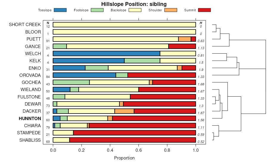
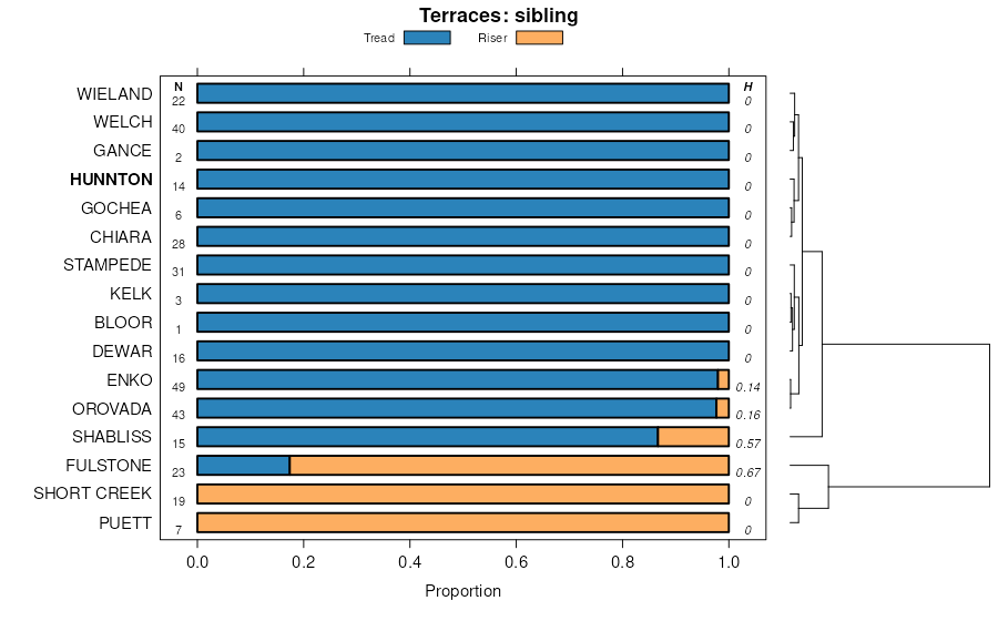
Cherry Spring-Hunnton-Chiara association | 1193 | 995 | 2519392 | 2qjp2 | nv612 | 1968 | 1:24000 |
Hunnton-Chiara-Wieland association | 486 | 53 | 2518901 | 2rn4p | nv612 | 1968 | 1:24000 |
Hunnton-Chiara-Wieland association | 486 | 6436 | 2633996 | 2rhhm | nv621 | 1971 | 1:24000 |
Hunnton-Chiara association | 481 | 3563 | 2633999 | 2t6gp | nv621 | 1971 | 1:24000 |
Fulstone-Fulstone, moderately steep-Hunnton association | 1231 | 33370 | 477048 | j0dn | nv763 | 1986 | 1:24000 |
Hunnton, moderately steep-Hunnton-Fulstone association | 1221 | 14210 | 477040 | j0dd | nv763 | 1986 | 1:24000 |
Hunnton-Chiara-Wieland association | 1229 | 13045 | 477046 | 2rn4p | nv763 | 1986 | 1:24000 |
Hunnton-Shabliss-Puett association | 1223 | 10279 | 477041 | j0df | nv763 | 1986 | 1:24000 |
Hunnton-Wieland-Clementine association | 1226 | 8250 | 477043 | j0dh | nv763 | 1986 | 1:24000 |
Hunnton-Hunnton, moderately sloping association | 1228 | 7990 | 477045 | j0dk | nv763 | 1986 | 1:24000 |
Hunnton, strongly sloping-Hunnton-Fulstone association | 1220 | 6235 | 477039 | j0dc | nv763 | 1986 | 1:24000 |
Shabliss-Hunnton-Bioya association | 1350 | 4850 | 477060 | j0f1 | nv763 | 1986 | 1:24000 |
Gumble-Tuffo-Hunnton association | 1852 | 4150 | 477132 | j0hc | nv763 | 1986 | 1:24000 |
Dacker-Hunnton association | 2611 | 3435 | 477198 | j0kh | nv763 | 1986 | 1:24000 |
Fulstone-Hunnton association | 1230 | 3170 | 477047 | j0dm | nv763 | 1986 | 1:24000 |
Wieland-Hunnton-Thwoop association | 2656 | 2570 | 477207 | j0ks | nv763 | 1986 | 1:24000 |
Hunnton-Chiara-Bilbo association | 1227 | 2550 | 477044 | j0dj | nv763 | 1986 | 1:24000 |
Hunnton-Trunk-Shabliss association | 1224 | 1390 | 477042 | j0dg | nv763 | 1986 | 1:24000 |
Cherry Spring-Hunnton-Chiara association | 1193 | 248 | 477036 | j0d8 | nv763 | 1986 | 1:24000 |
Hunnton-Wieland association | 485 | 174 | 2403498 | 2lp16 | nv764 | 2021 | 1:24000 |
Hunnton-Chiara-Wieland association | 486 | 60 | 2511449 | 2q906 | nv764 | 2021 | 1:24000 |
Dewar-Chiara-Hunnton association | 133 | 25980 | 474899 | hy5b | nv765 | 1986 | 1:24000 |
Dewar-Hunnton-Gance association | 131 | 15190 | 474897 | hy58 | nv765 | 1986 | 1:24000 |
Hunnton-Wieland association | 093 | 12289 | 474860 | hy42 | nv765 | 1986 | 1:24000 |
Wieland-Hunnton-Hunewill association | 082 | 6745 | 474857 | hy3z | nv765 | 1986 | 1:24000 |
Hunnton-Wieland-Gance association | 484 | 4409 | 2633849 | 2rgmq | nv765 | 1986 | 1:24000 |
Hunnton-Chiara-Wieland association | 094 | 3660 | 474861 | 2rn4p | nv765 | 1986 | 1:24000 |
Hunnton-Chiara-Bilbo association | 090 | 3150 | 474859 | hy41 | nv765 | 1986 | 1:24000 |
Dewar-Chiara-Hunnton association | 260 | 12640 | 478276 | 2t6wj | nv766 | 1994 | 1:24000 |
Shabliss-Parisa-Hunnton association | 485 | 1967 | 478353 | j1rr | nv766 | 1994 | 1:24000 |
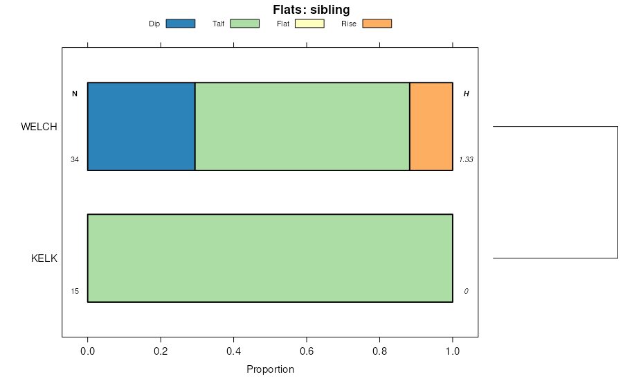
Hunnton-Wieland-Hunnton, gravelly association | 482 | 67521 | 478933 | j2cg | nv767 | 1986 | 1:24000 |
Hunnton-Wieland-Bilbo association | 478 | 48243 | 478929 | j2cb | nv767 | 1986 | 1:24000 |
Hunnton-Wieland-Gance association | 480 | 44261 | 478931 | j2cd | nv767 | 1986 | 1:24000 |
Hunnton-Wieland-Wieland, moderately steep association | 485 | 27476 | 478934 | j2ch | nv767 | 1986 | 1:24000 |
Hunnton-Chiara-Wieland association | 486 | 24367 | 478935 | 2rn4p | nv767 | 1986 | 1:24000 |
Hunnton-Wieland-Bioya association | 489 | 23268 | 478936 | j2ck | nv767 | 1986 | 1:24000 |
Hunnton-Chiara association | 481 | 14731 | 478932 | j2cf | nv767 | 1986 | 1:24000 |
Wieland-Hunnton-Tustell association | 1277 | 13364 | 478739 | j256 | nv767 | 1986 | 1:24000 |
Hunnton-Dacker association | 477 | 8981 | 478928 | j2c9 | nv767 | 1986 | 1:24000 |
Fulstone-Hunnton association | 1230 | 5761 | 478729 | j24w | nv767 | 1986 | 1:24000 |
Enko-Hunnton association | 225 | 3626 | 478838 | j28d | nv767 | 1986 | 1:24000 |
Gance-Chiara-Hunnton association | 432 | 3503 | 478907 | j2bm | nv767 | 1986 | 1:24000 |
Hunnton-Wieland-Bloor association | 479 | 3223 | 478930 | j2cc | nv767 | 1986 | 1:24000 |
Peeko-Hunnton-Puett association | 367 | 2514 | 478890 | j2b2 | nv767 | 1986 | 1:24000 |
Dewar-Chiara-Hunnton association | 147 | 189 | 2633863 | 2t6wj | nv767 | 1986 | 1:24000 |
Hunnton-Flue-McConnel association | 1172 | 17110 | 475429 | hyqf | nv777 | 1993 | 1:24000 |
Hunnton-Zevadez-Enko association | 1174 | 13907 | 475431 | hyqh | nv777 | 1993 | 1:24000 |
Hunnton very fine sandy loam, 2 to 8 percent slopes 1/ | 1173 | 12346 | 475430 | hyqg | nv777 | 1993 | 1:24000 |
Hunnton-Goosel-Connel association | 1175 | 11585 | 475432 | hyqj | nv777 | 1993 | 1:24000 |
Midraw-Hunnton association | 1362 | 10558 | 475505 | hysw | nv777 | 1993 | 1:24000 |
Chiara-Hunnton association | 186 | 10064 | 475616 | hyxg | nv777 | 1993 | 1:24000 |
Hunnton-Dacker association | 1176 | 7023 | 475433 | hyqk | nv777 | 1993 | 1:24000 |
Lunder-Hunnton association | 522 | 5561 | 475773 | hz2j | nv777 | 1993 | 1:24000 |
Rodock-Hunnton association | 1431 | 5489 | 475526 | hytk | nv777 | 1993 | 1:24000 |
Hunnton-Dugchip-Orovada association | 1171 | 3482 | 475428 | hyqd | nv777 | 1993 | 1:24000 |
Hunnton-Bliss-Trunk association | 1170 | 1794 | 475427 | hyqc | nv777 | 1993 | 1:24000 |
Hunnton-Chiara association | 1010 | 17696 | 480134 | 2t6gp | nv780 | 1990 | 1:24000 |
Fax-Hunnton-Cassiro association | 1090 | 7995 | 480156 | j3mx | nv780 | 1990 | 1:24000 |
Hunnton-Wieland-Kelk association | 1012 | 2190 | 480136 | j3m8 | nv780 | 1990 | 1:24000 |
Vanwyper family, very stony-Devada family, very stony-Hunnton family association, 0 to 35 percent slopes | 5659B | 7626 | 3423150 | 31v4t | nv792 | 2025 | 1:24000 |
Hunnton family-Devada family, very stony-Vanwyper family, very stony association, 0 to 20 percent slopes | 5659C | 964 | 3423151 | 31v4v | nv792 | 2025 | 1:24000 |

