Official Series Description


Lab Data Summary

Aggregate lab data for the HUMESTON soil series. This aggregation is based on all pedons with a current taxon name of HUMESTON, and applied along 1-cm thick depth slices. Solid lines are the slice-wise median, bounded on either side by the interval defined by the slice-wise 5th and 95th percentiles. The median is the value that splits the data in half. Five percent of the data are less than the 5th percentile, and five percent of the data are greater than the 95th percentile. Values along the right hand side y-axis describe the proportion of pedon data that contribute to aggregate values at this depth. For example, a value of "90%" at 25cm means that 90% of the pedons correlated to HUMESTON were used in the calculation. Source: KSSL snapshot . Methods used to assemble the KSSL snapshot used by SoilWeb / SDE

Click the image to view it full size.

Pedons used in the lab summary:

MLRALab IDPedon IDTaxonnameCINSSL / NASIS ReportsLink To SoilWeb GMap
107BM03041012003MO041001HUMESTON4Primary | Supplementary | Taxonomy | Pedon | Water Retention | Correlation | Andic Soil Properties39.6080556,-93.1355556
107B09N0786S09IA029003Humeston6Primary | Supplementary | Taxonomy | Pedon | Water Retention | Correlation | Andic Soil Properties41.3574181,-95.0638046
107B09N0787S09IA029005Humeston6Primary | Supplementary | Taxonomy | Pedon | Water Retention | Correlation | Andic Soil Properties41.3388062,-95.0839157
109M83079111983MO079011mHumeston2Primary | Supplementary | Taxonomy | Pedon | Water Retention | Correlation | Andic Soil Properties40.0486107,-93.6183319
109M89129041989MO129004mHumeston4Primary | Supplementary | Taxonomy | Pedon | Water Retention | Correlation | Andic Soil Properties40.4088889,-93.4152778
109M89129211989MO129021mHumeston4Primary | Supplementary | Taxonomy | Pedon | Water Retention | Correlation | Andic Soil Properties40.6916656,-93.7447205
10940A1483S1971IA185002HUMESTON7Primary | Supplementary | Taxonomy | Pedon | Water Retention | Correlation | Andic Soil Properties40.8194427,-93.4325027
115BM87171141987MO171014Humeston3Primary | Supplementary | Taxonomy | Pedon | Water Retention | Correlation | Andic Soil Properties38.9672203,-92.3450012
115BM90001331990MO001033Humeston4Primary | Supplementary | Taxonomy | Pedon | Water Retention | Correlation | Andic Soil Properties38.9672203,-92.3450012
115BM91197081991MO197008Humeston4Primary | Supplementary | Taxonomy | Pedon | Water Retention | Correlation | Andic Soil Properties38.9672203,-92.3450012
115BM91197741991MO197074Humeston4Primary | Supplementary | Taxonomy | Pedon | Water Retention | Correlation | Andic Soil Properties38.9672203,-92.3450012
115BM92197201992MO197020Humeston4Primary | Supplementary | Taxonomy | Pedon | Water Retention | Correlation | Andic Soil Properties38.9672203,-92.3450012

Water Balance

Monthly water balance estimated using a leaky-bucket style model for the HUMESTON soil series. Monthly precipitation (PPT) and potential evapotranspiration (PET) have been estimated from the 50th percentile of gridded values (PRISM 1981-2010) overlapping with the extent of SSURGO map units containing each series as a major component. Monthly PET values were estimated using the method of Thornthwaite (1948). These (and other) climatic parameters are calculated with each SSURGO refresh and provided by the fetchOSD function of the soilDB package. Representative water storage values (“AWC” in the figures) were derived from SSURGO by taking the 50th percentile of profile-total water storage (sum[awc_r * horizon thickness]) for each soil series. Note that this representation of “water storage” is based on the average ability of most plants to extract soil water between 15 bar (“permanent wilting point”) and 1/3 bar (“field capacity”) matric potential. Soil moisture state can be roughly interpreted as “dry” when storage is depleted, “moist” when storage is between 0mm and AWC, and “wet” when there is a surplus. Clearly there are a lot of assumptions baked into this kind of monthly water balance. This is still a work in progress.

Click the image to view it full size.


Click the image to view it full size.

Sibling Summary

Siblings are those soil series that occur together in map units, in this case with the HUMESTON series. Sketches are arranged according to their subgroup-level taxonomic structure. Source: SSURGO snapshot , parsed OSD records and snapshot of SC database .

Click the image to view it full size.

Select annual climate data summaries for the HUMESTON series and siblings. Series are sorted according to hierarchical clustering of median values. Source: SSURGO map unit geometry and 1981-2010, 800m PRISM data .

Click the image to view it full size.

Geomorphic description summaries for the HUMESTON series and siblings. Series are sorted according to hierarchical clustering of proportions and relative hydrologic position within an idealized landform (e.g. top to bottom). Most soil series (SSURGO components) are associated with a hillslope position and one or more landform-specific positions: hills, mountain slopes, terraces, and/or flats. Proportions can be interpreted as an aggregate representation of geomorphic membership. The values printed to the left (number of component records) and right (Shannon entropy) of stacked bars can be used to judge the reliability of trends. Small Shannon entropy values suggest relatively consistent geomorphic association, while larger values suggest lack thereof. Source: SSURGO component records .

Click the image to view it full size.

Click the image to view it full size.

There are insufficient data to create the 3D mountains figure.

Click the image to view it full size.

Click the image to view it full size.

Competing Series

Soil series competing with HUMESTON share the same family level classification in Soil Taxonomy. Source: parsed OSD records and snapshot of the SC database .

Click the image to view it full size.

Select annual climate data summaries for the HUMESTON series and competing. Series are sorted according to hierarchical clustering of median values. Source: SSURGO map unit geometry and 1981-2010, 800m PRISM data .

Click the image to view it full size.

Geomorphic description summaries for the HUMESTON series and competing. Series are sorted according to hierarchical clustering of proportions and relative hydrologic position within an idealized landform (e.g. top to bottom). Proportions can be interpreted as an aggregate representation of geomorphic membership. Most soil series (SSURGO components) are associated with a hillslope position and one or more landform-specific positions: hills, mountain slopes, terraces, and/or flats. The values printed to the left (number of component records) and right (Shannon entropy) of stacked bars can be used to judge the reliability of trends. Shannon entropy values close to 0 represent soil series with relatively consistent geomorphic association, while values close to 1 suggest lack thereof. Source: SSURGO component records .

Click the image to view it full size.

Click the image to view it full size.

There are insufficient data to create the 3D mountains figure.

Click the image to view it full size.

Click the image to view it full size.

Soil series sharing subgroup-level classification with HUMESTON, arranged according to family differentiae. Hovering over a series name will print full classification and a small sketch from the OSD. Source: snapshot of SC database .

Block Diagrams

Click a link below to display the diagram. Note that these diagrams may be from multiple survey areas.

  1. IA-2011-06-01-21 | Montgomery County - 1989

    Typical pattern of soils and parent material in the Nodaway-Colo-Zook association (Soil Survey of Montgomery County, Iowa; 1989).

  2. IA-2011-06-01-39 | Ringgold County - 1992

    Typical pattern of soils and parent material in the Nodaway-Humeston-Wabash association (Soil Survey of Ringgold County, Iowa; 1992).

  3. IA-2011-06-01-40 | Ringgold County - 1992

    Typical pattern of soils and parent material in the Gara-Armstrong-Pershing association (Soil Survey of Ringgold County, Iowa; 1992).

  4. IA-2011-06-01-41 | Ringgold County - 1992

    Typical pattern of soils and parent material in the Arispe-Shelby-Lamoni association (Soil Survey of Ringgold County, Iowa; 1992).

  5. IA-2011-06-01-42 | Ringgold County - 1992

    Relationship of the major soils in Ringgolg County to parent material and to position on the landscape (Soil Survey of Ringgold County, Iowa; 1992).

Map Units

Map units containing HUMESTON as a major component. Limited to 250 records.

Map Unit Name Symbol Map Unit Area (ac) Map Unit Key National Map Unit Symbol Soil Survey Area Publication Date Map Scale
Humeston silt loam, 0 to 2 percent slopes269893402167fhh4ia00119761:15840
Humeston silt loam, 0 to 2 percent slopes, occasionally flooded26924016894721tq13ia00320081:12000
Humeston silt loam, 0 to 2 percent slopes, occasionally flooded269A4094026702wjfgia00719701:15840
Humeston silt loam, 2 to 5 percent slopes269B156402671fj0dia00719701:15840
Humeston silty clay loam, 0 to 2 percent slopes, occasionally flooded269169186803920pvbia02920101:12000
Humeston silt loam, 0 to 2 percent slopes, occasionally flooded2692704041322wjfgia03919871:15840
Humeston silt loam, 0 to 2 percent slopes, occasionally flooded26911164046742wjfgia05119881:15840
Humeston silt loam, 0 to 2 percent slopes, occasionally flooded26930654047892wjfgia05319861:15840
Humeston silt loam269103406370fmvqia07719681:15840
Humeston silty clay loam, 0 to 2 percent slopes, occasionally flooded26911694089132wjfjia11719911:15840
Humeston silt loam, 0 to 2 percent slopes, overwash, occasionally flooded269+3684089142wbfhia11719911:15840
Humeston silt loam, 0 to 2 percent slopes269454409298fqx5ia12319711:15840
Humeston silt loam, 0 to 2 percent slopes269346409854frh3ia13719871:15840
Olmitz-Zook-Humeston complex, 0 to 5 percent slopes13B31848410653fs9wia15919871:15840
Humeston silty clay loam, 0 to 2 percent slopes, occasionally flooded26957424106812wjfjia15919871:15840
Humeston silty clay loam, 2 to 5 percent slopes, rarely flooded269B37894106832wjfkia15919871:15840
Humeston silt loam, 0 to 2 percent slopes, overwash, occasionally floodedS269+117230884962wbfhia15919871:15840
Humeston silt loam, 2 to 5 percent slopes, overwash, rarely flooded269B+7484106842wbfjia15919871:15840
Humeston silt loam, overwash, 0 to 2 percent slopes269+40410682fsbtia15919871:15840
Humeston silt loam, 0 to 2 percent slopes2691137411440ft48ia17119891:15840
Humeston silty clay loam, 0 to 2 percent slopes2694085411608ft9pia17319891:15840
Humeston silt loam, overwash, 0 to 2 percent slopes269+1377411609ft9qia17319891:15840
Humeston silty clay loam, 0 to 2 percent slopes269602411702ftdqia17519751:15840
Humeston silt loam, 0 to 2 percent slopes, occasionally flooded26921314117882wjfgia17919781:15840
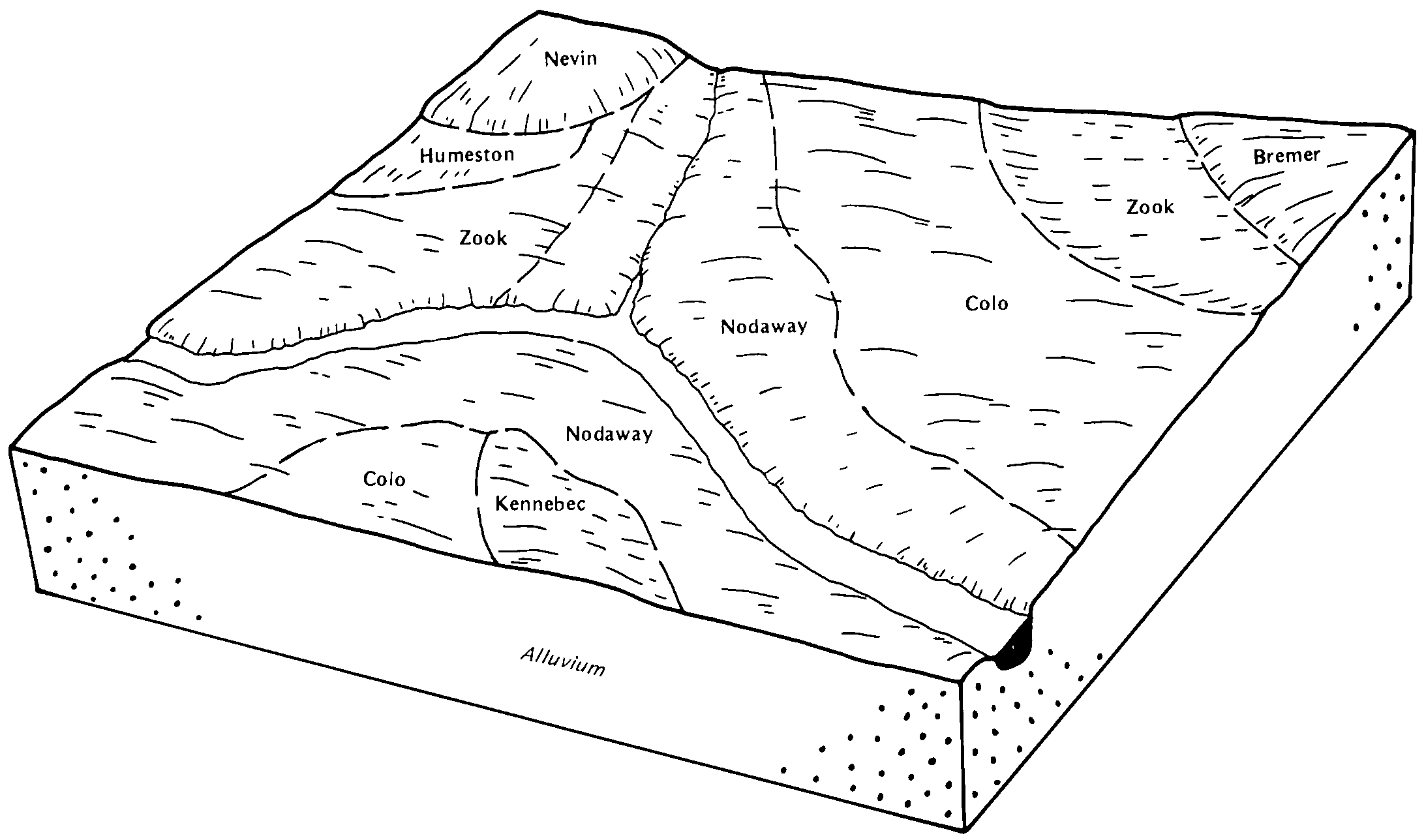
Humeston-Vesser-Colo complex, 2 to 5 percent slopes13B1218411767ftgtia17919781:15840
Humeston silt loam, 0 to 2 percent slopes269318411917ftmnia18119751:15840
Humeston silty clay loam, 0 to 2 percent slopes269367412031ftrbia18319831:15840
Humeston silty clay loam, 2 to 5 percent slopes, rarely flooded269B78724225582wjfkia18519661:15840
Humeston silty clay loam, 0 to 2 percent slopes, occasionally flooded26976318604742wjfjia18519661:15840
Humeston silt loam, 0 to 2 percent slopes, rarely flooded34010172125320092qnv3mo07519821:24000
Humeston silt loam, 1 to 4 percent slopes, rarely flooded3402240425445212qs1qmo07519821:24000
Humeston silt loam, 1 to 3 percent slopes, occasionally flooded360821325445512qs25mo07519821:24000
Humeston silt loam, 0 to 2 percent slopes, occasionally flooded36016282025320972wjfgmo07919881:24000
Humeston silt loam, 1 to 3 percent slopes, occasionally flooded3608212125445532qs25mo07919881:24000
Humeston silty clay loam, 0 to 2 percent slopes, occasionally flooded36017625321032wjfjmo07919881:24000
Humeston silt loam, 0 to 2 percent slopes, occasionally flooded36016711425320982wjfgmo08119751:24000
Humeston silt loam, 1 to 3 percent slopes, occasionally flooded3608257325445502qs25mo08119751:24000
Humeston silt loam, 0 to 2 percent slopes, occasionally flooded36016312025320992wjfgmo11519871:24000
Humeston silt loam, 1 to 3 percent slopes, occasionally flooded3608267325445522qs25mo11519871:24000
Nodaway-Humeston-Vigar complex, 1 to 6 percent slopes360891241825445792qs2gmo12919931:24000
Humeston silty clay loam, 0 to 2 percent slopes, occasionally flooded36017527125321042wjfjmo12919931:24000
Humeston silt loam, 0 to 2 percent slopes, occasionally flooded3601611225321002wjfgmo12919931:24000
Humeston silty clay loam, 0 to 2 percent slopes, occasionally flooded36017180925321052wjfjmo17119891:24000
Arbela and Humeston soils, 0 to 2 percent slopes, occasionally flooded36002183025320242qnv6mo19719931:24000
Arbela and Humeston soils, 0 to 2 percent slopes, occasionally flooded3600289525320232qnv6mo19919691:24000
Humeston silt loam, 0 to 2 percent slopes, occasionally flooded360164425321012wjfgmo21119901:24000
Humeston silty clay loam, 0 to 2 percent slopes, occasionally flooded36017525321022wjfjmo21119901:24000
Humeston loam, 0 to 2 percent slopes, occasionally flooded36000695887673yspmmo22719651:24000
Humeston silt loam, 0 to 2 percent slopes, rarely flooded340106225320082qnv3mo22719651:24000
Humeston silt loam, 0 to 2 percent slopes, occasionally flooded360162125320952wjfgmo22719651:24000

Map of Series Extent

Approximate geographic distribution of the HUMESTON soil series. To learn more about how this distribution was mapped, or to compare this soil series extent to others, use the Series Extent Explorer (SEE) application. Source: generalization of SSURGO geometry .