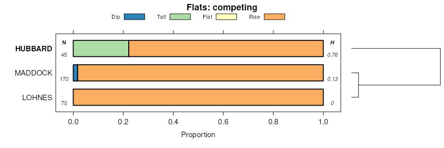
| Hubbard loamy sand, 0 to 2 percent slopes | D67A | 5356 | 395935 | 2w0mk | mn003 | 1972 | 1:15840 |
Hubbard loamy sand, 1 to 6 percent slopes | D67B | 4002 | 2765411 | 2w0ml | mn003 | 1972 | 1:15840 |
Hubbard loamy sand, 2 to 12 percent slopes | D67C | 1363 | 395937 | 2w0mm | mn003 | 1972 | 1:15840 |
Urban land-Hubbard complex, Mississippi River Valley, 0 to 8 percent slopes | D64B | 1282 | 885357 | 2smhh | mn003 | 1972 | 1:15840 |
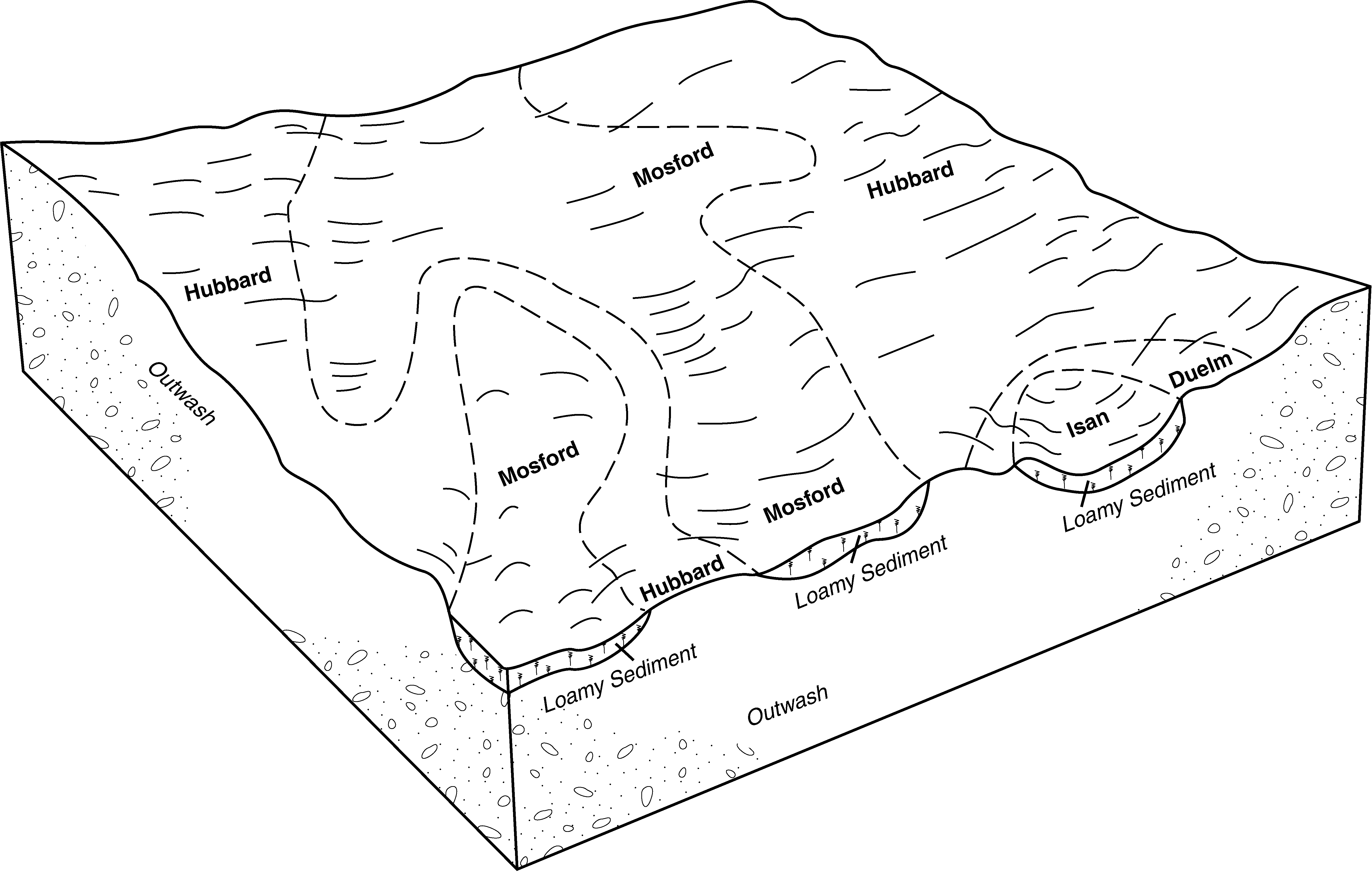
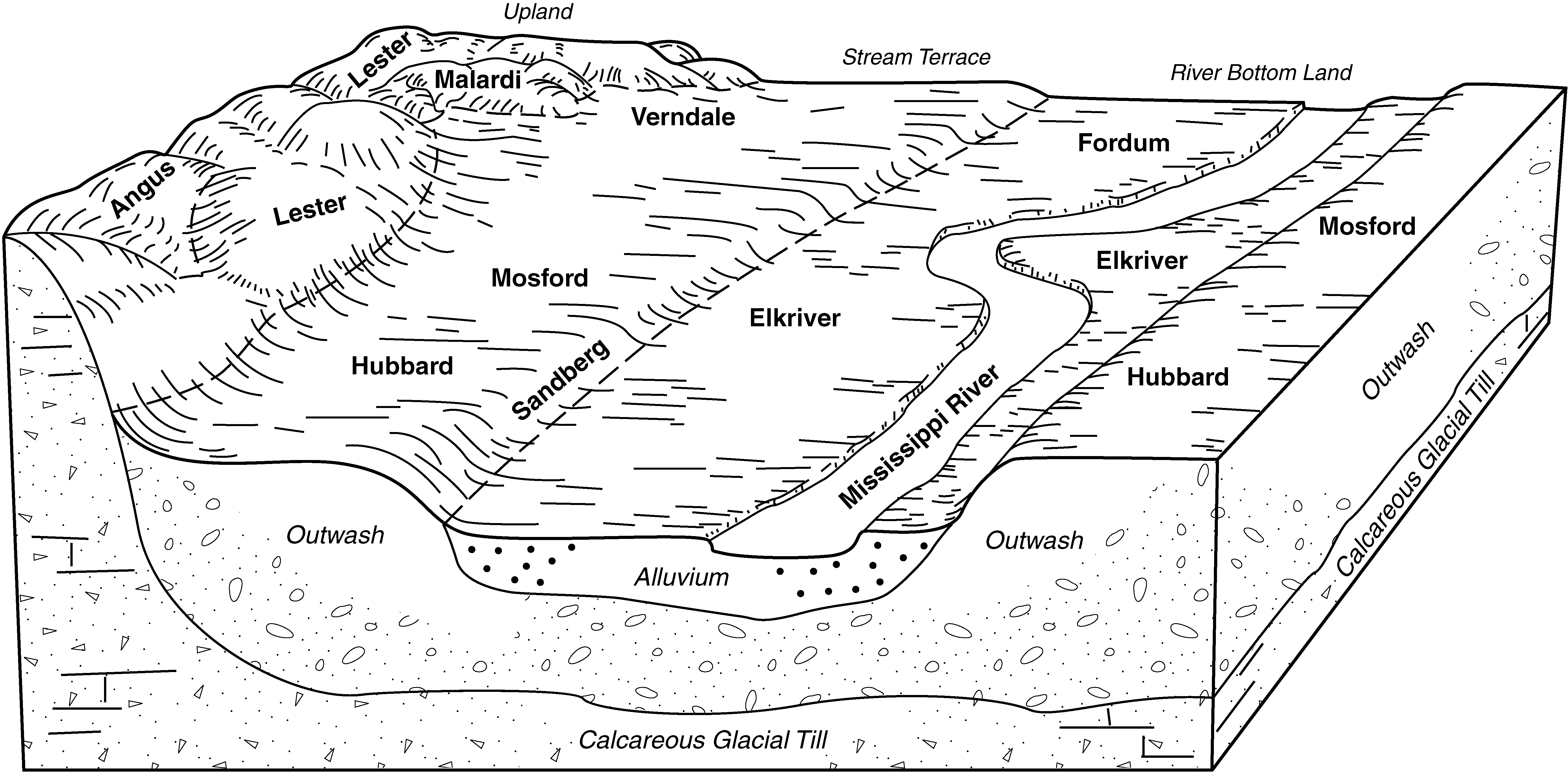
Hubbard-Mosford complex, Mississippi River Valley, 0 to 3 percent slopes | D62A | 71 | 2765447 | 2smhf | mn003 | 1972 | 1:15840 |
Hubbard coarse sand, 2 to 6 percent slopes | HuB | 10 | 395936 | f904 | mn003 | 1972 | 1:15840 |
Hubbard loamy sand, 0 to 2 percent slopes | D67A | 13052 | 2765415 | 2w0mk | mn009 | 2007 | 1:12000 |
Hubbard loamy sand, 1 to 6 percent slopes | D67B | 6399 | 2765416 | 2w0ml | mn009 | 2007 | 1:12000 |
Hubbard loamy sand, 0 to 2 percent slopes | D7A | 2528 | 709869 | rtp0 | mn009 | 2007 | 1:12000 |
Hubbard loamy sand, 2 to 6 percent slopes | D7B | 1756 | 709870 | rtp1 | mn009 | 2007 | 1:12000 |
Hubbard loamy sand, 6 to 12 percent slopes | D7C | 558 | 729058 | sgn0 | mn009 | 2007 | 1:12000 |
Hubbard loamy sand, 2 to 12 percent slopes | D67C | 511 | 2765417 | 2w0mm | mn009 | 2007 | 1:12000 |
Hubbard, bedrock substratum-Rock outcrop complex, 1 to 8 percent slopes | D54B | 122 | 785255 | vc3t | mn009 | 2007 | 1:12000 |
Hubbard-Mosford complex, Mississippi River Valley, 0 to 3 percent slopes | D62A | 100 | 752886 | 2smhf | mn009 | 2007 | 1:12000 |
Hubbard loamy sand, Mississippi River Valley, 18 to 35 percent slopes | D67E | 93 | 2765418 | 2smhd | mn009 | 2007 | 1:12000 |
Hubbard loamy sand, 18 to 35 percent slopes | D7E | 44 | 753012 | t8kq | mn009 | 2007 | 1:12000 |
Hubbard loamy sand, 0 to 2 percent slopes | D67A | 6878 | 2765419 | 2w0mk | mn021 | 1993 | 1:20000 |
Hubbard loamy sand, 1 to 6 percent slopes | D67B | 2111 | 2765420 | 2w0ml | mn021 | 1993 | 1:20000 |
Hubbard loamy sand, Mississippi River Valley, 0 to 2 percent slopes | D67A | 3002 | 2732678 | 2sln1 | mn035 | 2009 | 1:24000 |
Hubbard loamy sand, Mississippi River Valley, 2 to 6 percent slopes | D67B | 1077 | 2732679 | 2sln2 | mn035 | 2009 | 1:24000 |
Hubbard loamy sand, well drained, Mississippi River Valley, 0 to 3 percent slopes | D100A | 596 | 2732688 | 2slnd | mn035 | 2009 | 1:24000 |
Sandberg-Hubbard complex, Mississippi River Valley, 0 to 3 percent slopes | D97A | 330 | 2732684 | 2sln8 | mn035 | 2009 | 1:24000 |
Hubbard loamy sand, Mississippi River Valley, 6 to 12 percent slopes | D67C | 204 | 2732680 | 2sln3 | mn035 | 2009 | 1:24000 |
Hubbard loamy sand, 1 to 6 percent slopes | 7B | 2180 | 396882 | f9zn | mn037 | 1980 | 1:15840 |
Urban land-Hubbard complex, 0 to 6 percent slopes | 865B | 1228 | 396894 | fb01 | mn037 | 1980 | 1:15840 |
Hubbard loamy sand, 6 to 12 percent slopes | 7C | 1168 | 396883 | f9zp | mn037 | 1980 | 1:15840 |
Hubbard loamy sand, 0 to 1 percent slopes | 7A | 808 | 396881 | f9zm | mn037 | 1980 | 1:15840 |
Hubbard loamy sand, 12 to 18 percent slopes | 7D | 752 | 396884 | f9zq | mn037 | 1980 | 1:15840 |
Urban land-Hubbard complex, Mississippi River Valley, 0 to 8 percent slopes | D64B | 15060 | 435221 | 2smhh | mn053 | 2001 | 1:12000 |
Hubbard loamy sand, 0 to 2 percent slopes | D67A | 4455 | 451632 | 2w0mk | mn053 | 2001 | 1:12000 |
Hubbard loamy sand, 1 to 6 percent slopes | D67B | 3173 | 451631 | 2w0ml | mn053 | 2001 | 1:12000 |
Hubbard loamy sand, 2 to 12 percent slopes | D67C | 674 | 451630 | 2w0mm | mn053 | 2001 | 1:12000 |
Urban land-Hubbard, bedrock substratum complex, 0 to 8 percent slopes | D29B | 558 | 435214 | glw5 | mn053 | 2001 | 1:12000 |
Hubbard loamy fine sand, 2 to 7 percent slopes | Hu | 997 | 398358 | fcj8 | mn059 | 1956 | 1:20000 |
Hubbard loamy fine sand, 0 to 2 percent slopes | H | 447 | 398356 | fcj6 | mn059 | 1956 | 1:20000 |
Hubbard loamy fine sand, 7 to 12 percent slopes | Hp | 79 | 398357 | fcj7 | mn059 | 1956 | 1:20000 |
Hubbard loamy sand, lake beach, 2 to 8 percent slopes | C114B | 221 | 1676440 | 1t8gq | mn095 | 2006 | 1:12000 |
Hubbard loamy sand, lake beach, 8 to 20 percent slopes | C114D | 41 | 1676441 | 1t8gr | mn095 | 2006 | 1:12000 |
Hubbard loamy sand, 0 to 2 percent slopes | D67A | 13073 | 2765426 | 2w0mk | mn097 | 1987 | 1:20000 |
Hubbard loamy sand, 1 to 6 percent slopes | D67B | 8676 | 2765427 | 2w0ml | mn097 | 1987 | 1:20000 |
Hubbard loamy sand, 1 to 6 percent slopes | 7B | 13315 | 435954 | 2w0ml | mn111 | 1996 | 1:20000 |
Hubbard loamy sand, 0 to 2 percent slopes | 7A | 10234 | 435953 | 2w0mk | mn111 | 1996 | 1:20000 |
Hubbard loamy sand, 2 to 12 percent slopes | 7C | 2525 | 435955 | 2w0mm | mn111 | 1996 | 1:20000 |
Hubbard-Mosford complex, Mississippi River Valley, 0 to 3 percent slopes | D62A | 37699 | 2765436 | 2smhf | mn141 | 1994 | 1:15840 |
Hubbard loamy sand, 1 to 6 percent slopes | D67B | 14950 | 2765434 | 2w0ml | mn141 | 1994 | 1:15840 |
Hubbard loamy sand, 0 to 2 percent slopes | D67A | 5879 | 2765435 | 2w0mk | mn141 | 1994 | 1:15840 |
Hubbard loamy sand, 2 to 12 percent slopes | D67C | 3562 | 2765433 | 2w0mm | mn141 | 1994 | 1:15840 |
Hubbard-Verndale, acid substratum, complex, Mississippi River Valley, 0 to 3 percent slopes | D61A | 1680 | 2765437 | 2smhg | mn141 | 1994 | 1:15840 |
Hubbard loamy sand, 2 to 6 percent slopes | 7B | 665 | 431502 | gh0f | mn141 | 1994 | 1:15840 |
Hubbard-Verndale complex, 0 to 3 percent slopes | 1224 | 501 | 431435 | ggy8 | mn141 | 1994 | 1:15840 |
Hubbard loamy sand, 0 to 2 percent slopes | 7A | 399 | 431501 | gh0d | mn141 | 1994 | 1:15840 |
Hubbard loamy sand, 6 to 12 percent slopes | 7C | 131 | 431503 | gh0g | mn141 | 1994 | 1:15840 |
Hubbard loamy sand, 1 to 6 percent slopes | D67B | 18676 | 2765439 | 2w0ml | mn145 | 1980 | 1:15840 |
Hubbard loamy sand, 0 to 2 percent slopes | D67A | 11227 | 2765438 | 2w0mk | mn145 | 1980 | 1:15840 |
Urban land-Hubbard complex, Mississippi River Valley, 0 to 8 percent slopes | D64B | 3139 | 2765441 | 2smhh | mn145 | 1980 | 1:15840 |
Hubbard loamy sand, 2 to 12 percent slopes | D67C | 3004 | 2765440 | 2w0mm | mn145 | 1980 | 1:15840 |
Hubbard loamy sand, 1 to 6 percent slopes | 7B | 9539 | 428571 | 2w0ml | mn153 | 1985 | 1:20000 |
Hubbard loamy sand, 0 to 2 percent slopes | 7A | 4684 | 428570 | 2w0mk | mn153 | 1985 | 1:20000 |
Hubbard loamy sand, 1 to 6 percent slopes | 7B | 1246 | 1677040 | 1t932 | mn163 | 1978 | 1:15840 |
Hubbard loamy sand, 12 to 18 percent slopes | 7D | 757 | 1677042 | 1t934 | mn163 | 1978 | 1:15840 |
Hubbard loamy sand, 6 to 12 percent slopes | 7C | 452 | 1677041 | 1t933 | mn163 | 1978 | 1:15840 |
Hubbard-Mosford complex, Mississippi River Valley, 0 to 3 percent slopes | D62A | 4207 | 435042 | 2smhf | mn171 | 1998 | 1:12000 |
Hubbard loamy sand, 1 to 6 percent slopes | D67B | 1215 | 433633 | 2w0ml | mn171 | 1998 | 1:12000 |
Hubbard-Verndale, acid substratum, complex, Mississippi River Valley, 0 to 3 percent slopes | D61A | 1098 | 435043 | 2smhg | mn171 | 1998 | 1:12000 |
Hubbard loamy sand, 0 to 2 percent slopes | D67A | 755 | 433617 | 2w0mk | mn171 | 1998 | 1:12000 |
Hubbard loamy sand, 2 to 12 percent slopes | D67C | 661 | 433632 | 2w0mm | mn171 | 1998 | 1:12000 |
Hubbard loamy sand, river valleys, 0 to 3 percent slopes, occasionally flooded | 702A | 301 | 3182115 | 2yt31 | wi001 | 1978 | 1:20000 |
Hubbard loamy sand, river valleys, 0 to 3 percent slopes, occasionally flooded | 702A | 60 | 3182135 | 2yt31 | wi053 | 1994 | 1:12000 |
Hubbard loamy sand, 0 to 6 percent slopes | 3702B | 1994 | 421189 | g48r | wi095 | 1978 | 1:15840 |
Hubbard-Mosford complex, 0 to 6 percent slopes | 6119B | 17 | 2427650 | 2mh59 | wi095 | 1978 | 1:15840 |
Hubbard loamy sand, river valleys, 0 to 3 percent slopes, occasionally flooded | 702A | 34 | 3182161 | 2yt31 | wi097 | 1972 | 1:20000 |
Hubbard loamy sand, 0 to 6 percent slopes | 3702B | 1413 | 422150 | g58r | wi109 | 1975 | 1:15840 |
Hubbard loamy sand, loamy substratum, 0 to 6 percent slopes | 3703B | 1249 | 422151 | g58s | wi109 | 1975 | 1:15840 |
Hubbard loamy sand, loamy substratum, 6 to 12 percent slopes | 3703C | 598 | 422152 | g58t | wi109 | 1975 | 1:15840 |
Hubbard loamy sand, river valleys, 0 to 3 percent slopes, occasionally flooded | 702A | 2459 | 3182198 | 2yt31 | wi141 | 1971 | 1:12000 |

