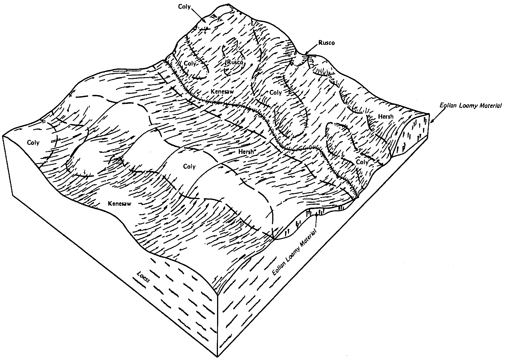
| Hersh fine sandy loam, 3 to 6 percent slopes | 2596 | 1428 | 1691915 | 30trz | ne001 | 1970 | 1:20000 |
Hersh-Kenesaw complex, undulating | 2615 | 454 | 1691916 | 1tsky | ne001 | 1970 | 1:20000 |
Hersh fine sandy loam, 0 to 3 percent slopes | 2595 | 36 | 2216101 | 30try | ne001 | 1970 | 1:20000 |
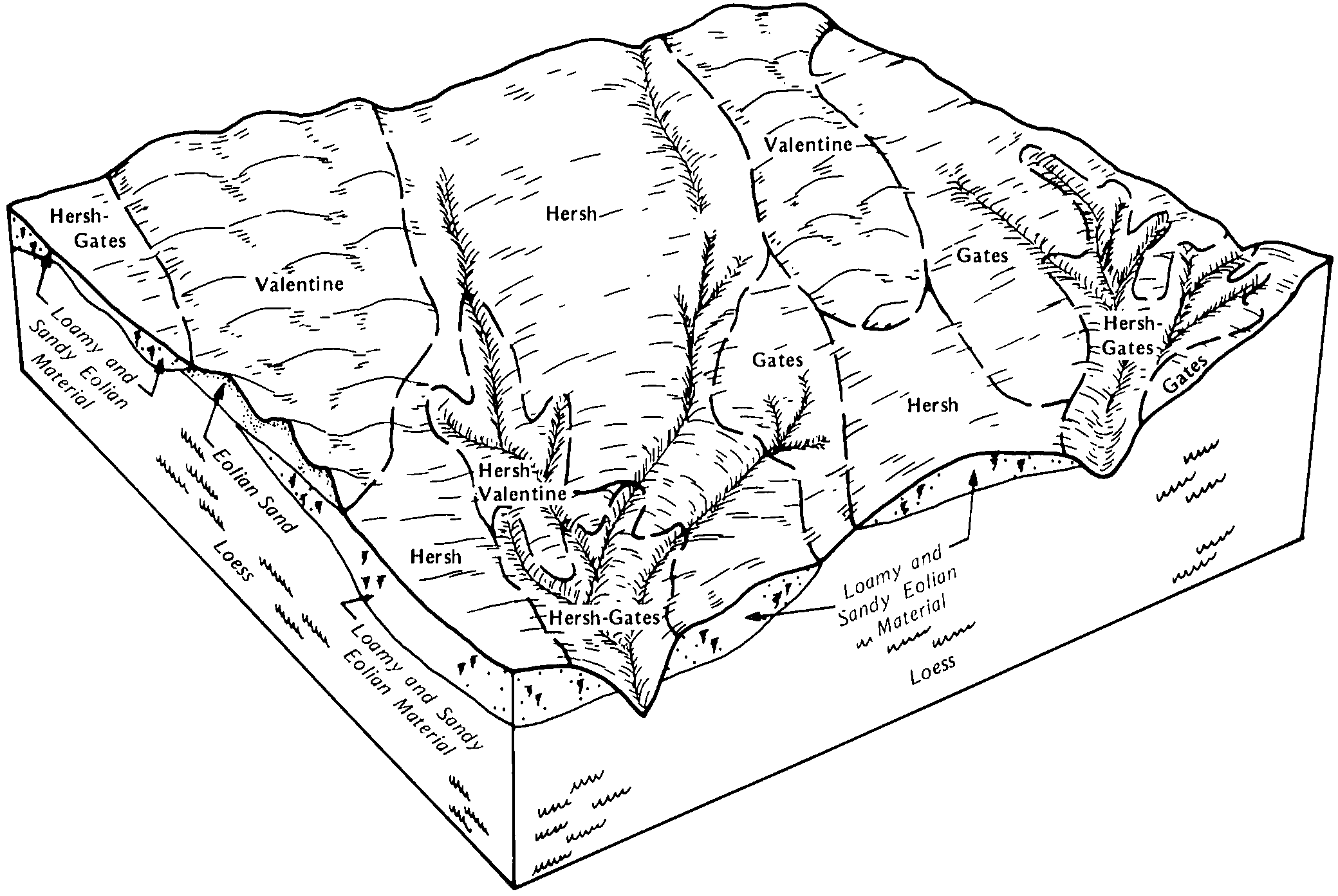
Hersh-Gates complex, 0 to 3 percent slopes | 2604 | 2501 | 1699486 | 2ymc2 | ne009 | 1988 | 1:20000 |
Gates-Hersh complex, 20 to 60 percent slopes | 9043 | 985 | 1699484 | 2ymc0 | ne009 | 1988 | 1:20000 |
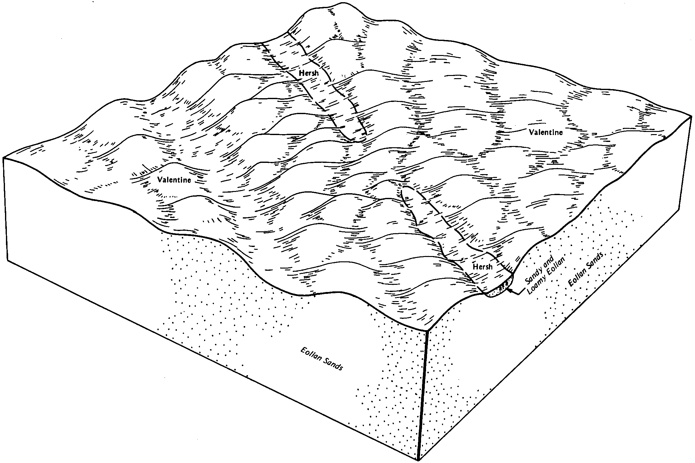
Hersh loamy fine sand, 3 to 6 percent slopes | 2600 | 196 | 1699485 | 2ymc1 | ne009 | 1988 | 1:20000 |
Uly, eroded-Hersh complex, 11 to 60 percent slopes | 2828 | 93 | 2606035 | 2yd3y | ne011 | 1966 | 1:20000 |
Hersh fine sandy loam, 3 to 6 percent slopes | 2596 | 28 | 2228225 | 2dsn7 | ne019 | 1967 | 1:20000 |
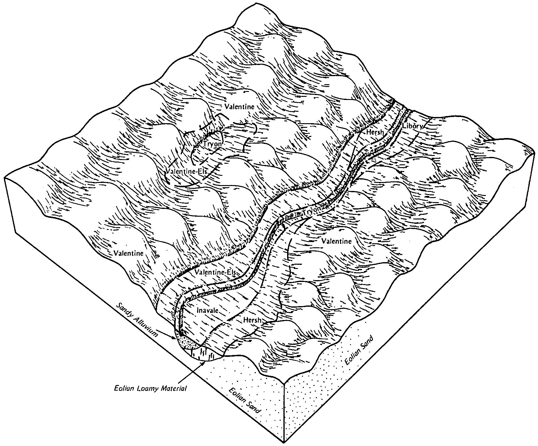
Hersh-Valentine complex, 11 to 30 percent slopes | 2611 | 25745 | 3030740 | 2wgdy | ne041 | 1980 | 1:20000 |
Hersh fine sandy loam, 3 to 6 percent slopes | 2596 | 19727 | 1699602 | 2wgdw | ne041 | 1980 | 1:20000 |
Hersh fine sandy loam, 6 to 11 percent slopes | 2597 | 18426 | 1699603 | 2wgdx | ne041 | 1980 | 1:20000 |
Hersh fine sandy loam, 0 to 3 percent slopes | 2595 | 15540 | 1699601 | 2wgdv | ne041 | 1980 | 1:20000 |
Gates-Hersh complex, 20 to 60 percent slopes | 9043 | 13270 | 1699593 | 2ymc0 | ne041 | 1980 | 1:20000 |
Hersh fine sandy loam, 11 to 17 percent slopes | 2598 | 3684 | 1699604 | 2wgdz | ne041 | 1980 | 1:20000 |
Hersh loamy fine sand, 3 to 6 percent slopes | 2600 | 90 | 2228172 | 2ymc1 | ne041 | 1980 | 1:20000 |
Valentine-Hersh complex, 11 to 30 percent slopes | 4864 | 2861 | 1691991 | 1tsnc | ne061 | 1974 | 1:20000 |
Hersh-Valentine complex, 6 to 11 percent slopes | 2609 | 2699 | 1691955 | 1tsm6 | ne061 | 1974 | 1:20000 |
Hersh-Valentine complex, 0 to 6 percent slopes | 2608 | 1016 | 1691954 | 1tsm5 | ne061 | 1974 | 1:20000 |
Hersh fine sandy loam, 3 to 6 percent slopes | 2596 | 5238 | 1699786 | 2wgdw | ne071 | 1984 | 1:20000 |
Hersh-Valentine complex, 11 to 30 percent slopes | 2611 | 5147 | 1699789 | 2wgdy | ne071 | 1984 | 1:20000 |
Hersh fine sandy loam, 6 to 11 percent slopes | 2597 | 4314 | 1699787 | 2wgdx | ne071 | 1984 | 1:20000 |
Hersh-Gates complex, 0 to 3 percent slopes | 2604 | 4264 | 1699788 | 2ymc2 | ne071 | 1984 | 1:20000 |
Hersh fine sandy loam, 0 to 3 percent slopes | 2595 | 2431 | 1699785 | 2wgdv | ne071 | 1984 | 1:20000 |
Hersh-Gates complex, 17 to 30 percent slopes | 2605 | 6396 | 1699948 | 30tsv | ne077 | 1987 | 1:20000 |
Gates-Hersh complex, 0 to 3 percent slopes | 9042 | 5779 | 1699941 | 2ymbz | ne077 | 1987 | 1:20000 |
Hersh fine sandy loam, 3 to 6 percent slopes | 2596 | 3189 | 1699945 | 2wgdw | ne077 | 1987 | 1:20000 |
Hersh fine sandy loam, 6 to 11 percent slopes | 2597 | 2720 | 1699946 | 2wgdx | ne077 | 1987 | 1:20000 |
Hersh fine sandy loam, 0 to 3 percent slopes | 2595 | 1042 | 1699944 | 2wgdv | ne077 | 1987 | 1:20000 |
Hersh fine sandy loam, 11 to 17 percent slopes | 2598 | 773 | 1699947 | 2wgdz | ne077 | 1987 | 1:20000 |
Hersh fine sandy loam, silty substratum, 3 to 6 percent slopes | 2599 | 1406 | 1700137 | 30tst | ne079 | 2003 | 1:12000 |
Hersh fine sandy loam, 3 to 6 percent slopes | 2596 | 2607 | 1691849 | 30trz | ne099 | 1982 | 1:20000 |
Hersh fine sandy loam, 0 to 3 percent slopes | 2595 | 1927 | 1691848 | 30try | ne099 | 1982 | 1:20000 |
Hersh fine sandy loam, 6 to 11 percent slopes | 2597 | 1088 | 1691850 | 30ts0 | ne099 | 1982 | 1:20000 |
Hersh-Valentine complex, 6 to 11 percent slopes | 2609 | 9 | 2219446 | 2dhj1 | ne099 | 1982 | 1:20000 |
Hersh fine sandy loam, 3 to 6 percent slopes | 2596 | 18600 | 2219716 | 2wgdw | ne111 | 1971 | 1:24000 |
Hersh-Valentine loamy fine sands, 0 to 6 percent slopes | 2607 | 13181 | 1699172 | 30tsx | ne111 | 1971 | 1:24000 |
Hersh fine sandy loam, 6 to 11 percent slopes | 2597 | 12612 | 2219780 | 2wgdx | ne111 | 1971 | 1:24000 |
Hersh and Anselmo soils, 11 to 30 percent slopes | 2591 | 7181 | 1699175 | 30tss | ne111 | 1971 | 1:24000 |
Hersh-Anselmo fine sandy loams, 1 to 3 percent slopes | 2603 | 3231 | 1699171 | 1v13z | ne111 | 1971 | 1:24000 |
Hersh and Valentine soils, 6 to 11 percent slopes | 2594 | 3152 | 1699176 | 318hx | ne111 | 1971 | 1:24000 |
Hersh-Valentine complex, 11 to 30 percent slopes | 2611 | 1349 | 2219715 | 2wgdy | ne111 | 1971 | 1:24000 |
Hersh fine sandy loam, 11 to 17 percent slopes | 2598 | 28 | 2219781 | 2wgdz | ne111 | 1971 | 1:24000 |
Hersh and Anselmo fine sandy loams, 0 to 3 percent slopes | 2590 | 14 | 2219714 | 318hw | ne111 | 1971 | 1:24000 |
Hersh-Valentine complex, 11 to 30 percent slopes | 2611 | 8728 | 1699359 | 2wgdy | ne113 | 1969 | 1:24000 |
Hersh and Valentine soils, 6 to 11 percent slopes | 2594 | 3562 | 1699358 | 318hx | ne113 | 1969 | 1:24000 |
Hersh fine sandy loam, 3 to 6 percent slopes | 2596 | 2943 | 1699356 | 2wgdw | ne113 | 1969 | 1:24000 |
Hersh and Anselmo fine sandy loams, 0 to 3 percent slopes | 2590 | 1793 | 1699357 | 318hw | ne113 | 1969 | 1:24000 |
Hersh fine sandy loam, 0 to 3 percent slopes | 2595 | 39 | 2219795 | 2wgdv | ne113 | 1969 | 1:24000 |
Hersh fine sandy loam, 6 to 11 percent slopes | 2597 | 26 | 2219796 | 2wgdx | ne113 | 1969 | 1:24000 |
Hersh-Gates complex, 0 to 3 percent slopes | 2604 | 5212 | 1699537 | 2ymc2 | ne115 | 1986 | 1:20000 |
Hersh fine sandy loam, 3 to 6 percent slopes | 2596 | 3917 | 1699535 | 2wgdw | ne115 | 1986 | 1:20000 |
Hersh-Valentine complex, 11 to 30 percent slopes | 2611 | 2865 | 1699539 | 2wgdy | ne115 | 1986 | 1:20000 |
Hersh-Gates complex, 30 to 60 percent slopes | 2606 | 2312 | 1699538 | 30tsw | ne115 | 1986 | 1:20000 |
Hersh fine sandy loam, 6 to 11 percent slopes | 2597 | 2187 | 1699536 | 2wgdx | ne115 | 1986 | 1:20000 |
Hersh fine sandy loam, 0 to 3 percent slopes | 2595 | 1709 | 1699534 | 2wgdv | ne115 | 1986 | 1:20000 |
Hersh loamy fine sand, 3 to 6 percent slopes | 2600 | 46 | 2219825 | 2ymc1 | ne115 | 1986 | 1:20000 |
Gates-Hersh complex, 20 to 60 percent slopes | 9043 | 10 | 2219820 | 2ymc0 | ne115 | 1986 | 1:20000 |
Nora-Hersh complex, 6 to 11 percent slopes, severely eroded | 6773 | 538 | 427494 | gbv4 | ne125 | 1958 | 1:20000 |
Nora-Hersh complex, 11 to 17 percent slopes, severely eroded | 6771 | 200 | 427495 | gbv5 | ne125 | 1958 | 1:20000 |
Uly, eroded-Hersh complex, 11 to 60 percent slopes | 2828 | 90 | 2606030 | 2yd3y | ne125 | 1958 | 1:20000 |
Hersh fine sandy loam, 0 to 3 percent slopes | 2595 | 5 | 2219462 | 30try | ne137 | 1967 | 1:20000 |
Hersh fine sandy loam, 3 to 6 percent slopes | 2596 | 1712 | 1699992 | 1v1zg | ne163 | 1987 | 1:20000 |
Hersh-Valentine complex, 11 to 24 percent slopes | 2610 | 976 | 1699993 | 1v1zh | ne163 | 1987 | 1:20000 |
Hersh fine sandy loam, 0 to 3 percent slopes | 2595 | 1191 | 1699889 | 2wgdv | ne175 | 1983 | 1:20000 |
Hersh fine sandy loam, 6 to 11 percent slopes | 2597 | 1117 | 1699891 | 2wgdx | ne175 | 1983 | 1:20000 |
Hersh fine sandy loam, 3 to 6 percent slopes | 2596 | 752 | 1699890 | 2wgdw | ne175 | 1983 | 1:20000 |
Hersh fine sandy loam, 11 to 17 percent slopes | 2598 | 354 | 1699892 | 2wgdz | ne175 | 1983 | 1:20000 |
Hersh fine sandy loam, 0 to 3 percent slopes | 2595 | 697 | 1699844 | 2wgdv | ne183 | 1984 | 1:20000 |
Gates-Hersh complex, 0 to 3 percent slopes | 9042 | 4 | 2219898 | 2ymbz | ne183 | 1984 | 1:20000 |