Official Series Description


Lab Data Summary

Aggregate lab data for the HERM soil series. This aggregation is based on all pedons with a current taxon name of HERM, and applied along 1-cm thick depth slices. Solid lines are the slice-wise median, bounded on either side by the interval defined by the slice-wise 5th and 95th percentiles. The median is the value that splits the data in half. Five percent of the data are less than the 5th percentile, and five percent of the data are greater than the 95th percentile. Values along the right hand side y-axis describe the proportion of pedon data that contribute to aggregate values at this depth. For example, a value of "90%" at 25cm means that 90% of the pedons correlated to HERM were used in the calculation. Source: KSSL snapshot . Methods used to assemble the KSSL snapshot used by SoilWeb / SDE

There are insufficient data to create the lab data summary figure.


Water Balance

Monthly water balance estimated using a leaky-bucket style model for the HERM soil series. Monthly precipitation (PPT) and potential evapotranspiration (PET) have been estimated from the 50th percentile of gridded values (PRISM 1981-2010) overlapping with the extent of SSURGO map units containing each series as a major component. Monthly PET values were estimated using the method of Thornthwaite (1948). These (and other) climatic parameters are calculated with each SSURGO refresh and provided by the fetchOSD function of the soilDB package. Representative water storage values (“AWC” in the figures) were derived from SSURGO by taking the 50th percentile of profile-total water storage (sum[awc_r * horizon thickness]) for each soil series. Note that this representation of “water storage” is based on the average ability of most plants to extract soil water between 15 bar (“permanent wilting point”) and 1/3 bar (“field capacity”) matric potential. Soil moisture state can be roughly interpreted as “dry” when storage is depleted, “moist” when storage is between 0mm and AWC, and “wet” when there is a surplus. Clearly there are a lot of assumptions baked into this kind of monthly water balance. This is still a work in progress.

Click the image to view it full size.


Click the image to view it full size.

Sibling Summary

Siblings are those soil series that occur together in map units, in this case with the HERM series. Sketches are arranged according to their subgroup-level taxonomic structure. Source: SSURGO snapshot , parsed OSD records and snapshot of SC database .

Click the image to view it full size.

Select annual climate data summaries for the HERM series and siblings. Series are sorted according to hierarchical clustering of median values. Source: SSURGO map unit geometry and 1981-2010, 800m PRISM data .

Click the image to view it full size.

Geomorphic description summaries for the HERM series and siblings. Series are sorted according to hierarchical clustering of proportions and relative hydrologic position within an idealized landform (e.g. top to bottom). Most soil series (SSURGO components) are associated with a hillslope position and one or more landform-specific positions: hills, mountain slopes, terraces, and/or flats. Proportions can be interpreted as an aggregate representation of geomorphic membership. The values printed to the left (number of component records) and right (Shannon entropy) of stacked bars can be used to judge the reliability of trends. Small Shannon entropy values suggest relatively consistent geomorphic association, while larger values suggest lack thereof. Source: SSURGO component records .

Click the image to view it full size.

Click the image to view it full size.

Click the image to view it full size.

Click the image to view it full size.

Click the image to view it full size.

Competing Series

Soil series competing with HERM share the same family level classification in Soil Taxonomy. Source: parsed OSD records and snapshot of the SC database .

Click the image to view it full size.

Select annual climate data summaries for the HERM series and competing. Series are sorted according to hierarchical clustering of median values. Source: SSURGO map unit geometry and 1981-2010, 800m PRISM data .

Click the image to view it full size.

Geomorphic description summaries for the HERM series and competing. Series are sorted according to hierarchical clustering of proportions and relative hydrologic position within an idealized landform (e.g. top to bottom). Proportions can be interpreted as an aggregate representation of geomorphic membership. Most soil series (SSURGO components) are associated with a hillslope position and one or more landform-specific positions: hills, mountain slopes, terraces, and/or flats. The values printed to the left (number of component records) and right (Shannon entropy) of stacked bars can be used to judge the reliability of trends. Shannon entropy values close to 0 represent soil series with relatively consistent geomorphic association, while values close to 1 suggest lack thereof. Source: SSURGO component records .

Click the image to view it full size.

Click the image to view it full size.

Click the image to view it full size.

Click the image to view it full size.

Click the image to view it full size.

Soil series sharing subgroup-level classification with HERM, arranged according to family differentiae. Hovering over a series name will print full classification and a small sketch from the OSD. Source: snapshot of SC database .

Block Diagrams

Click a link below to display the diagram. Note that these diagrams may be from multiple survey areas.

  1. NM-2012-02-14-09 | Jicarilla Apache Nation, Parts of Rio Arriba and Sandoval Counties - 2004

    Conceptual diagram of the major soil and landscape positions of the north-central portion of the survey area from Archuleta Mesa south (Soil Survey of Jicarilla Apache Nation, New Mexico, Parts of Rio Arriba and Sandoval Counties; 2004).

Map Units

Map units containing HERM as a major component. Limited to 250 records.

Map Unit Name Symbol Map Unit Area (ac) Map Unit Key National Map Unit Symbol Soil Survey Area Publication Date Map Scale
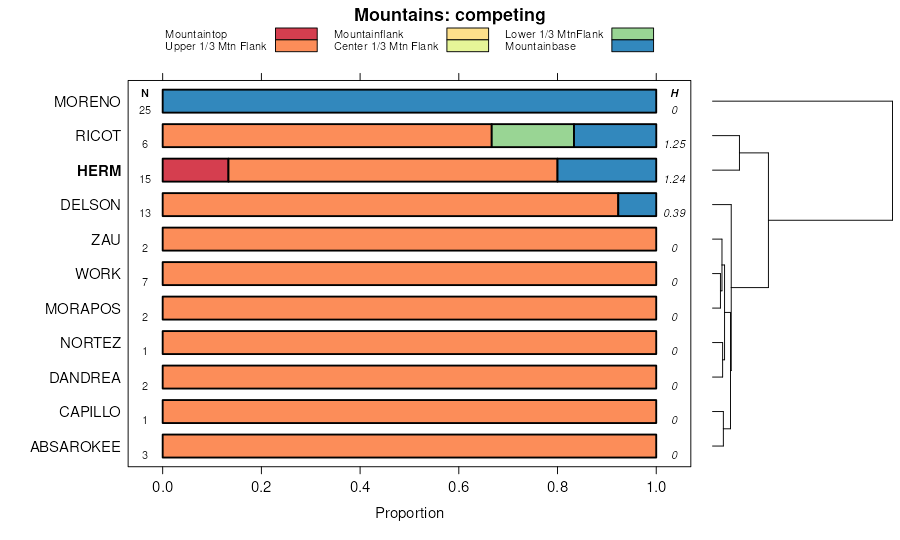
Herm family, 5 to 25 percent slopes, very stonyHm2419547036bpco62619741:24000
Herm family, 5 to 25 percent slopes532M3911509868k3kcco63620111:24000
Herm-Fughes complex, 10 to 20 percent slopes, extremely bouldery98123106843jpg8co6481:24000
Herm-Kolob families complex, 40 to 65 percent slopes333C785414149381jhc5co6541:24000
Herm-Fughes families complex, 5 to 40 percent slopes, eroded430B344214150241jhfyco6541:24000
Cerro-Herm complex, 15 to 40 percent slopesGM11787331283630gvcco6541:24000
Herm-Fughes-Kolob family complex, 25 to 40 percent slopes15834861509517k361co66019941:24000
Cerro-Herm complex, 15 to 40 percent slopes1175276509464k34bco66019941:24000
Weed-Herm complex, 0 to 25 percent slopes1953845509565k37lco66019941:24000
Cerro-Herm complex, 0 to 15 percent slopes1161561509463k349co66019941:24000
Herm-Kolob families complex, 40 to 65 percent slopes333C31331769231jhc5co66119681:31680
Herm family, clay loam, cool, 3 to 12 percent slopesC2-V1442217106311vf1nco66820181:24000
Herm family, clay loam, 3 to 12 percent slopesC2-CD4976737743srp5co66820181:24000
Herm family, clay loam, 12 to 25 percent slopesC2-E3493737742srp4co66820181:24000
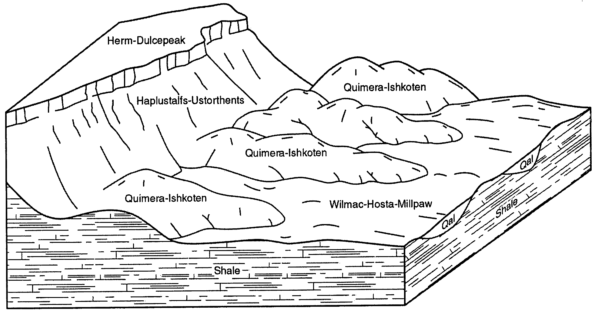
Herm family-Dulcepeak, stony complex, 3 to 25 percent slopesM5-D1962499282jrjwco66820181:24000
Herm family-Echolake complex, 3 to 10 percent slopesC3-CD1687737744srp6co66820181:24000
Herm family-Echolake, cool complex, 3 to 10 percent slopesC3-V140017119011vgcmco66820181:24000
Herm family, clay loam, warm, 12 to 25 percent slopesC2-EV414186837620q66co66820181:24000
Herm loam, 6 to 25 percent slopes378790582971ynkco66919821:24000
Herm variant clay loam, 2 to 8 percent slopes38802582981ynlco66919821:24000
Herm loam, 3 to 25 percent slopes40960614331nm84co67020051:24000
Herm very cobbly loam, 15 to 40 percent slopes502532576601y00co67119971:24000
Fughes-Herm complex, 1 to 35 percent slopes401110576432wqy8co67119971:24000
Herm-Pagoda complex, 0 to 15 percent slopes51468576671y07co67119971:24000
Herm loam, 6 to 25 percent slopes4912576541xztco67119971:24000
Burnson-Herm complex, 15 to 30 percent slopes166576041xy6co67119971:24000
Herm-Pagoda complex, 0 to 15 percent slopes5089668507188k0rxco67220031:24000
Burnson-Herm complex, 15 to 30 percent slopes5533216507200k0s9co67220031:24000
Fughes-Herm complex, 1 to 35 percent slopes5830347376932wqy8co67220031:24000
Fughes-Herm complex, 25 to 45 percent slopes59588737694srmlco67220031:24000
Herm loam, 6 to 25 percent slopes937113507299k0whco67220031:24000
Herm-Fughes-Godding complex, 5 to 45 percent slopes122600505174jynyco67419981:24000
Herm-Fughes complex, 10 to 20 percent slopes, extremely bouldery987027497279jpg8co68619921:31680
Caballo-Herm complex, 3 to 40 percent slopesCcE237027701402tl8cnm6721:24000
Herm-Ishkoten complex, 5 to 50 percent slopesHkF51227702182v5qhnm6721:24000
Herm-Dulcepeak, stony complex, 3 to 25 percent slopesHdE248529345092wkzrnm6781:24000
Herm-Lomapedro families complex, 0 to 15 percent slopes287201429343132wgl5nm6781:24000
Herm-Dula, frequently flooded complex, 0 to 15 percent slopesHmD24929345082wkzqnm6781:24000
Herm-Dulcepeak complex, 3 to 25 percent slopes56011704575241xvmnm69820001:24000
Herm-Iles stony loams, 3 to 25 percent slopes3817378553581vlrut63319831:24000
Herm-Tomasaki-Falcon complex, 25 to 65 percent slopes3917338553591vlsut63319831:24000
Toone-Sirref-Herm complex, 10 to 30 percent slopes9410106554201vnrut63319831:24000
Herm clay loam, 8 to 20 percent slopes371697553571vlqut63319831:24000

Map of Series Extent

Approximate geographic distribution of the HERM soil series. To learn more about how this distribution was mapped, or to compare this soil series extent to others, use the Series Extent Explorer (SEE) application. Source: generalization of SSURGO geometry .