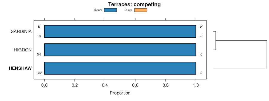
| Henshaw silt loam, 0 to 2 percent slopes, rarely flooded | 7483A | 136 | 714028 | 2wlv2 | il069 | 2003 | 1:12000 |
Henshaw silt loam, 0 to 2 percent slopes, rarely flooded | 7483A | 594 | 808126 | 2wlv2 | il127 | 2004 | 1:12000 |
Henshaw silt loam, 0 to 2 percent slopes, rarely flooded | 7483A | 64 | 608159 | 2wlv2 | il151 | 2003 | 1:12000 |
Henshaw silt loam, 0 to 2 percent slopes, frequently flooded | 3483A | 1884 | 2025108 | 25z92 | il191 | 2008 | 1:12000 |
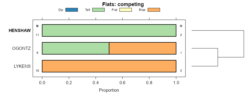
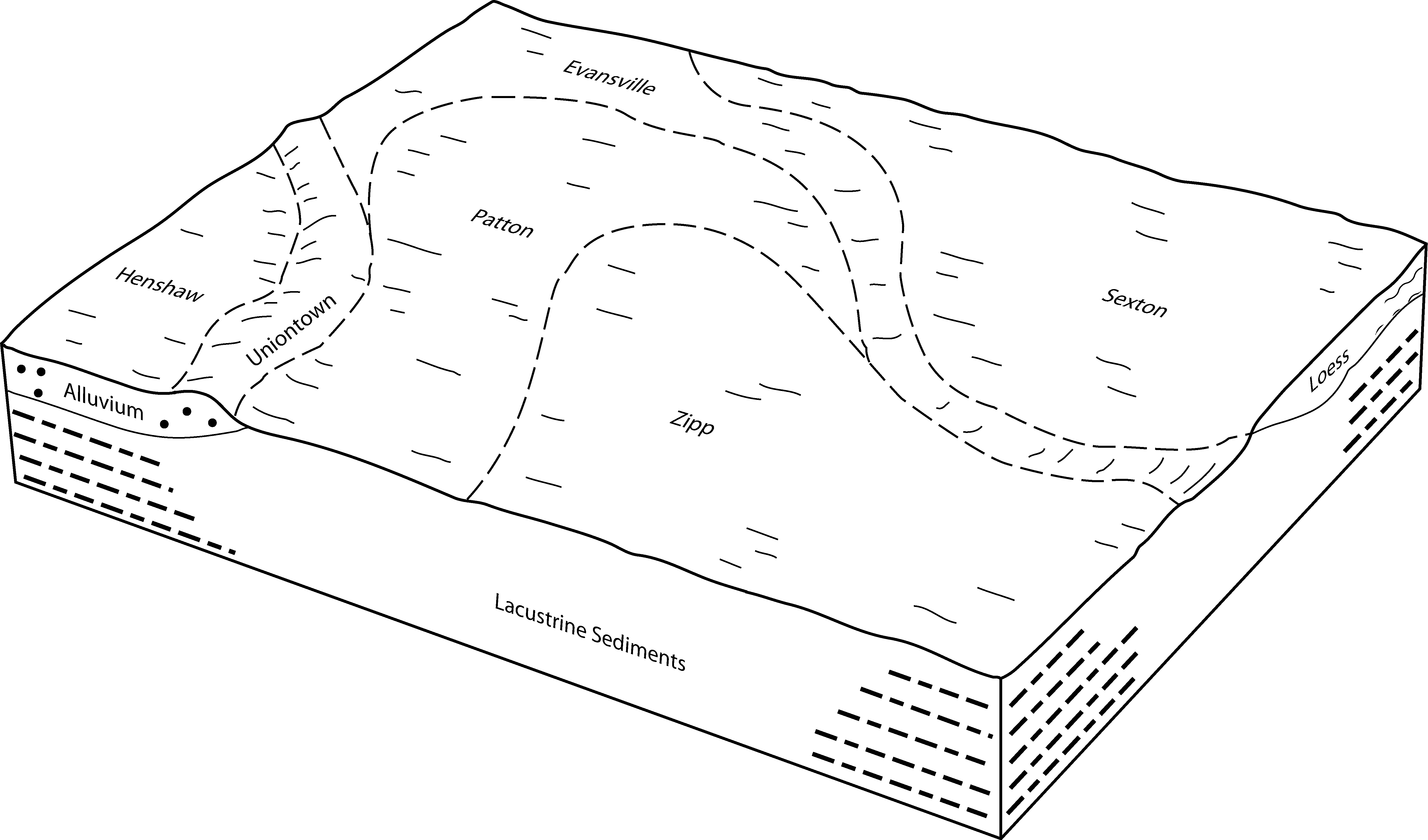
Henshaw silt loam, 0 to 2 percent slopes | 483A | 7347 | 1543919 | 1ntkv | il193 | 2006 | 1:12000 |
Henshaw silt loam, 0 to 2 percent slopes, rarely flooded | 7483A | 4712 | 1543975 | 1ntmn | il193 | 2006 | 1:12000 |
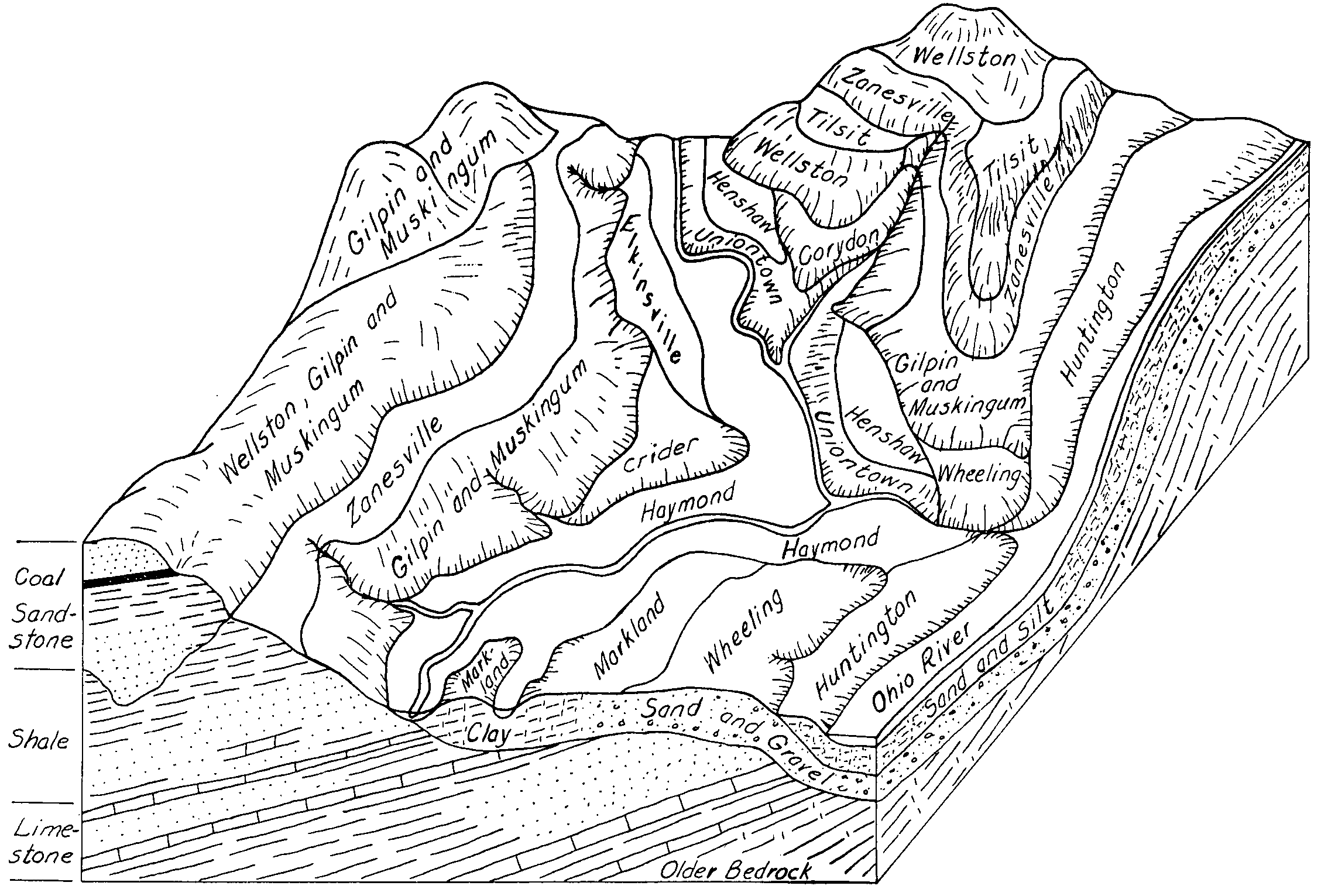
Henshaw silt loam, 1 to 3 percent slopes | HbA | 1072 | 159606 | 5c2l | in021 | 1980 | 1:15840 |
Henshaw silt loam, 0 to 3 percent slopes | HfeA | 285 | 1652617 | 1sgp7 | in025 | 1970 | 1:20000 |
Henshaw silt loam, 0 to 2 percent slopes, frequently flooded | HhA | 1351 | 160124 | 5cm9 | in051 | 1986 | 1:15840 |
Henshaw silt loam, 1 to 3 percent slopes | HdA | 1177 | 161551 | 5f3b | in055 | 1984 | 1:15840 |
Henshaw silt loam, 0 to 2 percent slopes | HeA | 1015 | 164481 | 5j4v | in083 | 1979 | 1:15840 |
Henshaw silt loam, 1 to 3 percent slopes, rarely flooded | HfiAQ | 1307 | 1651540 | 1sfkh | in093 | 1982 | 1:15840 |
Henshaw silt loam, 0 to 3 percent slopes | HeA | 371 | 161910 | 5fgx | in125 | 1983 | 1:15840 |
Henshaw silt loam, 0 to 2 percent slopes, rarely flooded | HeA | 8999 | 159888 | 5ccp | in129 | 1978 | 1:15840 |
Henshaw silt loam | He | 5733 | 160018 | 5chw | in147 | 1966 | 1:15840 |
Henshaw silt loam, 0 to 2 percent slopes | HeA | 2410 | 162678 | 5g8p | in153 | 1966 | 1:15840 |
Henshaw silt loam, 2 to 4 percent slopes, eroded | HeB2 | 221 | 162679 | 5g8q | in153 | 1966 | 1:15840 |
Henshaw silt loam | He | 2723 | 162740 | 5gbp | in163 | 1972 | 1:15840 |
Henshaw silt loam, 0 to 2 percent slopes, rarely flooded | HeA | 2917 | 159949 | 5cfn | in173 | 1976 | 1:15840 |
Henshaw silt loam, 0 to 2 percent slopes, rarely flooded | He | 272 | 1404754 | 2wlv2 | ky033 | 2005 | 1:12000 |
Henshaw silt loam, 0 to 2 percent slopes, rarely flooded | Hn | 2208 | 549061 | 2wlv2 | ky047 | 1977 | 1:20000 |
Henshaw silt loam, 0 to 2 percent slopes, rarely flooded | Hn | 173 | 549115 | 2wlv2 | ky055 | 1985 | 1:20000 |
Henshaw silt loam, 0 to 2 percent slopes, rarely flooded | He | 8606 | 549187 | 2wlv2 | ky101 | 1964 | 1:15840 |
Henshaw silt loam, 0 to 2 percent slopes, rarely flooded | Hn | 4151 | 549322 | 2wlv2 | ky139 | 1989 | 1:20000 |
Henshaw silt loam, 0 to 2 percent slopes, rarely flooded | He | 2177 | 551257 | 2wlv2 | ky183 | 1983 | 1:20000 |
Henshaw silt loam, 0 to 2 percent slopes, frequently flooded | HhA | 1329 | 1596139 | 1qkxc | ky602 | 1972 | 1:12000 |
Henshaw silt loam, 0 to 2 percent slopes, protected | HaA | 979 | 1597389 | 1qm6p | ky602 | 1972 | 1:12000 |
Henshaw silt loam, 0 to 2 percent slopes, rarely flooded | HeA | 652 | 1596147 | 2wlv2 | ky602 | 1972 | 1:12000 |
Henshaw silt loam, 0 to 2 percent slopes, occasionally flooded | HfA | 144 | 1597390 | 1qm6q | ky602 | 1972 | 1:12000 |
Henshaw silt loam, 0 to 2 percent slopes, rarely flooded | HeA | 1876 | 2232236 | 2wlv2 | ky610 | 1968 | 1:12000 |
Henshaw silt loam, 2 to 6 percent slopes, rarely flooded | HeB | 78 | 2623433 | 2qyk3 | ky610 | 1968 | 1:12000 |
Henshaw silt loam, 0 to 2 percent slopes, rarely flooded | He | 4044 | 549388 | 2wlv2 | ky615 | 1971 | 1:20000 |
Henshaw-Urban land complex, 0 to 2 percent slopes | uHeuA | 269 | 3098746 | 2wv5b | ky615 | 1971 | 1:20000 |
Henshaw silt loam, 0 to 2 percent slopes, rarely flooded | He | 4074 | 551104 | 2wlv2 | ky631 | 1976 | 1:20000 |
Henshaw silt loam, 0 to 2 percent slopes, rarely flooded | He | 4673 | 549507 | 2wlv2 | ky635 | 1978 | 1:20000 |
Henshaw silt loam, 0 to 2 percent slopes | HoA | 675 | 169769 | 5pnf | oh017 | 1977 | 1:15840 |
Urban land-Henshaw complex, 0 to 2 percent slopes | UHoA | 261 | 3381099 | 30tq5 | oh017 | 1977 | 1:15840 |
Henshaw-Urban land complex, 0 to 2 percent slopes | HoUA | 178 | 3381098 | 30tq4 | oh017 | 1977 | 1:15840 |
Henshaw silt loam, 0 to 2 percent slopes | HeA | 121 | 171445 | 5rdh | oh021 | 1966 | 1:15840 |
Henshaw silt loam, 2 to 6 percent slopes | HeB | 64 | 171446 | 5rdj | oh021 | 1966 | 1:15840 |
Henshaw silt loam, 0 to 2 percent slopes | HeA | 146 | 169239 | 5p3b | oh047 | 1968 | 1:15840 |
Henshaw silt loam, 0 to 2 percent slopes | HoA | 521 | 169403 | 5p8m | oh061 | 1980 | 1:15840 |
Urban land-Alfic Udarents-Henshaw complex, 0 to 6 percent slopes | UAHXB | 115 | 2652882 | 2qy7f | oh061 | 1980 | 1:15840 |
Henshaw-Urban land complex, 0 to 2 percent slopes | HoUA | 35 | 3404824 | 30tq4 | oh061 | 1980 | 1:15840 |
Henshaw silt loam, 0 to 2 percent slopes | HeA | 711 | 171122 | 5r22 | oh091 | 1977 | 1:15840 |
Henshaw silt loam, 2 to 6 percent slopes | HeB | 229 | 171123 | 5r23 | oh091 | 1977 | 1:15840 |
Henshaw silt loam, 0 to 4 percent slopes | HnA | 457 | 171268 | 5r6s | oh129 | 1977 | 1:15840 |
Henshaw silt loam, 0 to 4 percent slopes | HeA | 12 | 170884 | 5qtd | oh141 | 1997 | 1:15840 |
Henshaw silt loam, 0 to 2 percent slopes | HeA | 386 | 1406073 | 1j646 | oh159 | 1970 | 1:15840 |
Henshaw silt loam, 1 to 4 percent slopes | HoB | 828 | 171356 | 5r9m | oh165 | 1967 | 1:20000 |
Urban land-Henshaw complex, 1 to 4 percent slopes | UHoB | 75 | 3422266 | 31gj5 | oh165 | 1967 | 1:20000 |
Henshaw-Urban land complex, 1 to 4 percent slopes | HoUB | 44 | 3422265 | 31gj4 | oh165 | 1967 | 1:20000 |
