| Hector-Rock outcrop complex, 10 to 45 percent slopes | HrF | 65621 | 328376 | 2sr8f | al009 | 1974 | 1:24000 |
Hartsells-Hector complex, 6 to 15 percent slopes | HhD | 26457 | 328374 | 2sr7x | al009 | 1974 | 1:24000 |
Hector-Rock outcrop complex, 2 to 10 percent slopes | HrC | 9010 | 328375 | c0pr | al009 | 1974 | 1:24000 |
Linker-Hector complex, 2 to 10 percent slopes | LhC | 2873 | 328382 | c0pz | al009 | 1974 | 1:24000 |
Hector-Hartsells-Rock outcrop complex, 2 to 10 percent slopes (gorgas-hartsells-rock outcrop) | HdC | 4560 | 523010 | kk79 | al019 | 1973 | 1:20000 |
Bankhead-Hector-Rock outcrop complex, 15 to 60 percent slopes | BhG | 470 | 2494536 | 2psf5 | al075 | 2010 | 1:24000 |
Townley-Hector association, 15 to 40 percent slopes | 38 | 46250 | 330641 | 2sr8g | al093 | 1976 | 1:20000 |
Hector-Rock outcrop association, 15 to 50 percent slopes | 10 | 38500 | 330611 | 2wc2f | al093 | 1976 | 1:20000 |
Hector fine sandy loam, eroded, hilly | Hm | 2211 | 331092 | c3jd | al103 | 1949 | 1:15840 |
Hector fine sandy loam, severely eroded, hilly | Ho | 1327 | 331094 | c3jg | al103 | 1949 | 1:15840 |
Hector stony fine sandy loam, steep | Hr | 816 | 331097 | c3jk | al103 | 1949 | 1:15840 |
Hector stony fine sandy loam, hilly | Hq | 746 | 331096 | c3jj | al103 | 1949 | 1:15840 |
Hector stony fine sandy loam, eroded, hilly | Hp | 642 | 331095 | c3jh | al103 | 1949 | 1:15840 |
Hector fine sandy loam, hilly | Hn | 588 | 331093 | c3jf | al103 | 1949 | 1:15840 |
Rock land-Hector-Townley association, steep | RHE | 1755 | 523256 | kkh7 | al121 | 1969 | 1:20000 |
Linker-Hector complex, 12 to 40 percent slopes | LhF | 4745 | 565816 | lzs4 | ar067 | 1971 | 1:20000 |
Hector-Mountainburg stony fine sandy loams, 3 to 40 percent slopes, rocky | HoF | 36177 | 566590 | 2vz7z | ar143 | 1966 | 1:20000 |
Allen-Hector complex, 20 to 40 percent slopes (nella) | AhF | 21699 | 566550 | m0jt | ar143 | 1966 | 1:20000 |
Allen-Hector complex, 40 to 55 percent slopes (nella) | AhG | 11222 | 566551 | m0jv | ar143 | 1966 | 1:20000 |
Fayetteville-Hector complex, 20 to 40 percent slopes | FhF | 4867 | 566585 | m0ky | ar143 | 1966 | 1:20000 |
Hector-Mountainburg gravelly fine sandy loam, 3 to 8 percent slopes | HmC | 4513 | 566588 | m0l1 | ar143 | 1966 | 1:20000 |
Hector-Mountainburg gravelly fine sandy loams, 8 to 12 percent slopes | HmD | 1858 | 566589 | m0l2 | ar143 | 1966 | 1:20000 |
Hector-Townley-Rock outcrop complex, 5 to 35 percent slopes | HrE | 60 | 2023854 | 25xzm | ga129 | 2007 | 1:12000 |
Hartsells-Hector complex, 15 to 35 percent slopes, rocky | HcE | 25652 | 2480316 | 2wc2b | ga619 | 2012 | 1:24000 |
Rock outcrop-Hector complex, 5 to 60 percent slopes | RhF | 14173 | 2567650 | 2qyn1 | ga619 | 2012 | 1:24000 |
Hartsells-Hector complex, 2 to 10 percent slopes | HcC | 10510 | 2480315 | 2wc2c | ga619 | 2012 | 1:24000 |
Hartsells-Hector complex, 6 to 15 percent slopes, rocky | HcD | 7367 | 2567642 | 2wc2d | ga619 | 2012 | 1:24000 |
Hector-Townley-Rock outcrop complex, 5 to 35 percent slopes | HrE | 869 | 2679830 | 2qvq8 | ga619 | 2012 | 1:24000 |
Hector stony fine sandy loam, 15 to 40 percent slopes | HeF | 18720 | 531272 | kttt | ga621 | 1975 | 1:20000 |
Hector stony fine sandy loam, 6 to 15 percent slopes | HeD | 2390 | 531271 | ktts | ga621 | 1975 | 1:20000 |
Nella-Hector-Townley complex, 30 to 60 percent slopes, rubbly | NtF | 1680 | 562970 | lwtb | ga648 | 2001 | 1:12000 |
Hector-Townley-Rock outcrop complex, 5 to 35 percent slopes | HrF | 1375 | 562947 | lwsl | ga648 | 2001 | 1:12000 |
Bolivar-Hector complex, 5 to 15 percent slopes | 9211 | 1254 | 1427081 | 2vwg5 | ks011 | 1979 | 1:24000 |
Bolivar-Hector complex, 5 to 15 percent slopes | 9211 | 3420 | 1426902 | 2vwg5 | ks021 | 1983 | 1:24000 |
Bolivar-Hector complex, 5 to 15 percent slopes | 9211 | 2667 | 1387023 | 1hk9p | ks037 | 1969 | 1:24000 |
Bolivar-Hector complex, 5 to 15 percent slopes | 9211 | 5 | 1468882 | 2vwg5 | ks045 | 1974 | 1:24000 |
Bolivar-Hector complex, 5 to 15 percent slopes | 9211 | 2885 | 1460741 | 2vwg5 | ks059 | 1979 | 1:24000 |
Bolivar-Hector loams, 2 to 5 percent slopes | 9210 | 1107 | 1460740 | 1l10n | ks059 | 1979 | 1:24000 |
Bolivar-Hector complex, 5 to 15 percent slopes | 9211 | 3842 | 1426871 | 2vwg5 | ks099 | 1987 | 1:24000 |
Hector fine sandy loam, 2 to 5 percent slopes | 40099 | 3298 | 886806 | 2xvgz | mo011 | 1969 | 1:24000 |
Hector fine sandy loam, 5 to 14 percent slopes, stony | 40102 | 2701 | 2532475 | 2xvgv | mo011 | 1969 | 1:24000 |
Hector fine sandy loam, 5 to 14 percent slopes | 40100 | 2451 | 2532473 | 2xvgy | mo011 | 1969 | 1:24000 |
Hector fine sandy loam, 14 to 30 percent slopes, stony | 40103 | 2058 | 2532479 | 2xvgw | mo011 | 1969 | 1:24000 |
Hector fine sandy loam, 5 to 25 percent slopes, stony | 40101 | 44161 | 886964 | 2xvgt | mo185 | 1984 | 1:24000 |
Hector fine sandy loam, 14 to 30 percent slopes, stony | 40103 | 175 | 2532477 | 2xvgw | mo185 | 1984 | 1:24000 |
Hector fine sandy loam, 5 to 14 percent slopes | 40100 | 12662 | 2532474 | 2xvgy | mo217 | 1974 | 1:24000 |
Hector fine sandy loam, 5 to 14 percent slopes, stony | 40102 | 10655 | 2532476 | 2xvgv | mo217 | 1974 | 1:24000 |
Hector fine sandy loam, 14 to 30 percent slopes, stony | 40103 | 3085 | 2532478 | 2xvgw | mo217 | 1974 | 1:24000 |
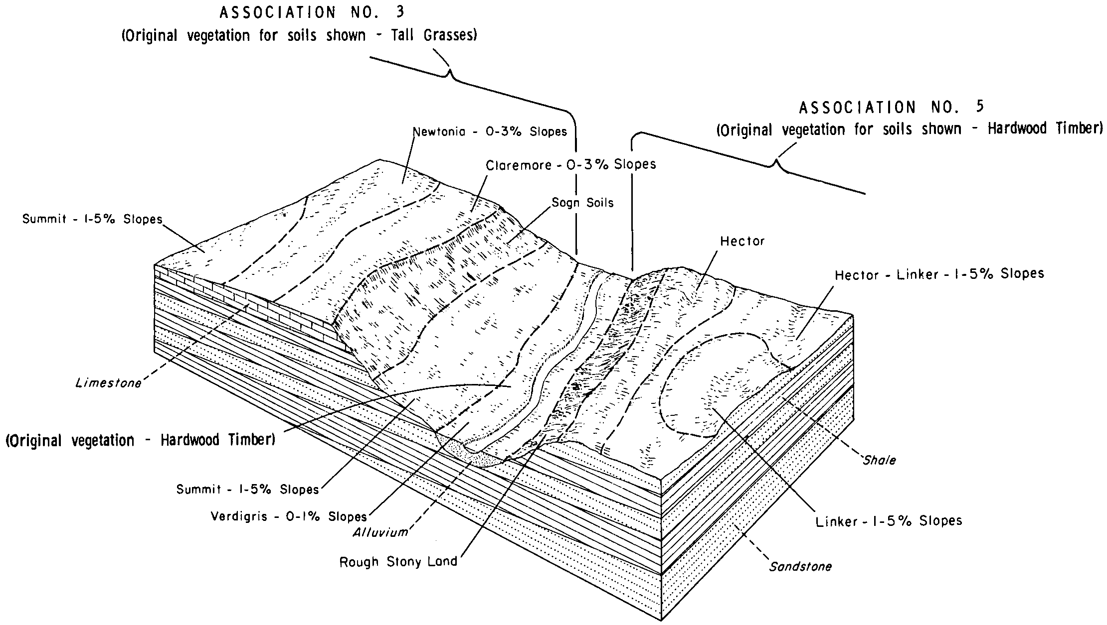
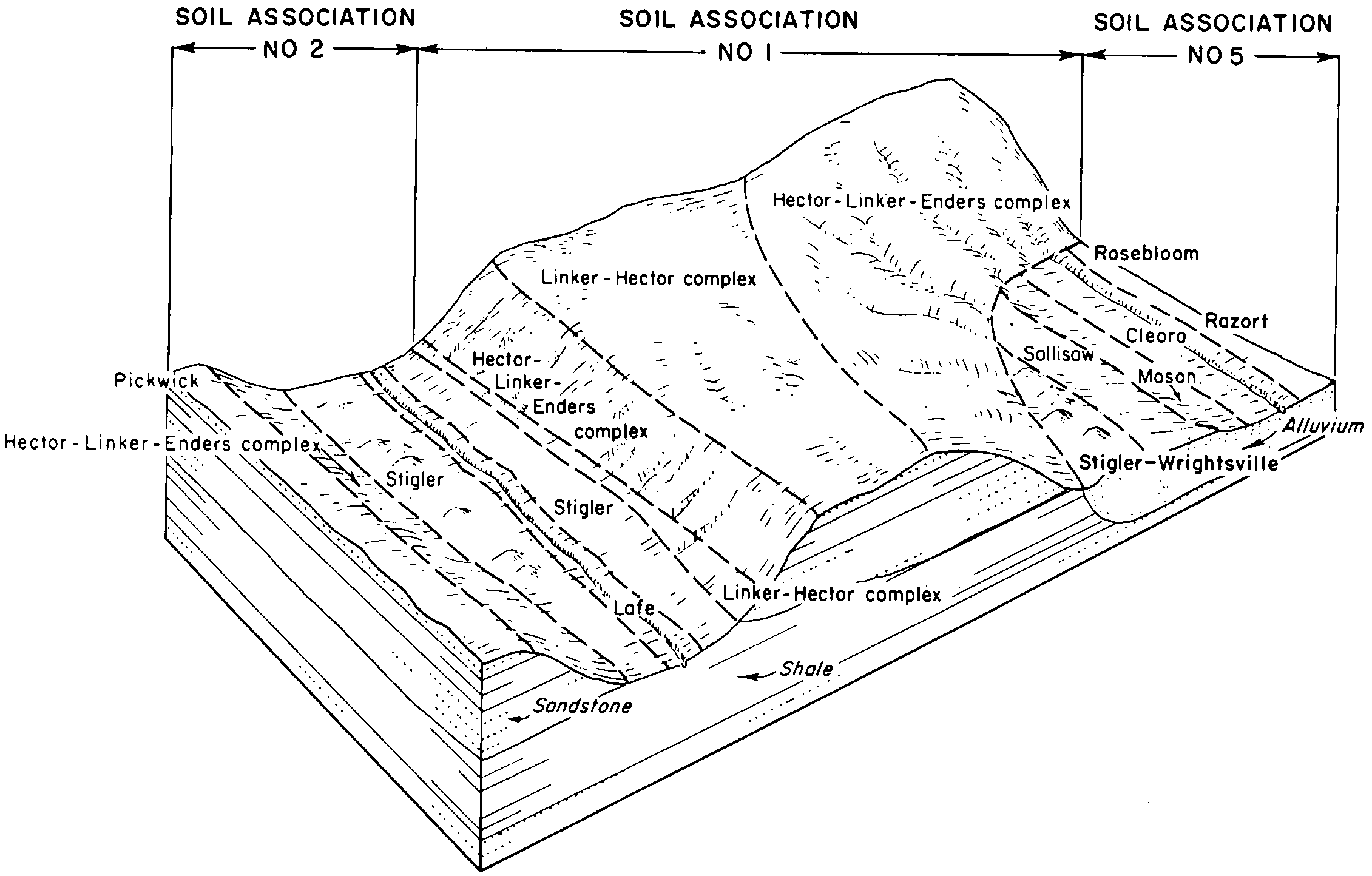
Enders-Linker-Hector association, 5 to 30 percent slopes | Hc | 81010 | 571786 | 2pwxm | ok001 | 1963 | 1:24000 |
Hector-Linker complex, 1 to 5 percent slopes | HlC | 12560 | 571787 | 2vz8b | ok001 | 1963 | 1:24000 |
Endsaw-Hector complex, 8 to 30 percent slopes, very rocky | 36 | 20040 | 571350 | 2vz82 | ok005 | 1977 | 1:24000 |
Endsaw-Hector complex, 5 to 8 percent slopes | 35 | 7176 | 571349 | m5jm | ok005 | 1977 | 1:24000 |
Endsaw-Hector complex, 3 to 5 percent slopes | 34 | 7173 | 571348 | m5jl | ok005 | 1977 | 1:24000 |
Endsaw-Hector complex, 30 to 50 percent slopes | 37 | 546 | 571351 | m5jp | ok005 | 1977 | 1:24000 |
Clearview-Hector complex, 3 to 5 percent slopes, gullied | 47 | 541 | 571362 | 2sp26 | ok005 | 1977 | 1:24000 |
Enders-Linker-Hector association, 5 to 30 percent slopes | HlE | 89570 | 571816 | 2pwxm | ok021 | 1967 | 1:24000 |
Hector fine sandy loam, 3 to 5 percent slopes | HcC | 21858 | 571815 | 2vz81 | ok021 | 1967 | 1:24000 |
Rock outcrop-Hector complex, 40 to 100 percent slopes | Rs | 11021 | 571827 | m611 | ok021 | 1967 | 1:24000 |
Homa-Hector complex, 12 to 20 percent slopes | HoE | 68704 | 571600 | m5sq | ok029 | 1969 | 1:24000 |
Homa-Hector complex, 20 to 45 percent slopes | HoF | 2425 | 571601 | m5sr | ok029 | 1969 | 1:24000 |
Hector-Bolivar complex, 5 to 20 percent slopes | HlE | 10332 | 106509 | 2xvh1 | ok035 | 1968 | 1:20000 |
Hector-Bolivar complex, 1 to 5 percent slopes | HlC | 7685 | 106508 | 2xvh0 | ok035 | 1968 | 1:20000 |
Hector-Linker association, 8 to 30 percent slopes | HlE | 50 | 571858 | m621 | ok041 | 1967 | 1:24000 |
Hector fine sandy loam, 3 to 5 percent slopes | HcC | 21 | 571857 | m620 | ok041 | 1967 | 1:24000 |
Hector-Linker complex, 3 to 5 percent slopes | HlC | 27976 | 571684 | 2vz80 | ok061 | 1972 | 1:24000 |
Hector stony loam, 3 to 12 percent slopes, stony | HcD | 13454 | 571683 | 2vz84 | ok061 | 1972 | 1:24000 |
Linker-Hector complex, 3 to 8 percent slopes, severely eroded | LnD3 | 11120 | 571693 | m5wq | ok061 | 1972 | 1:24000 |
Hector-Endsaw complex, 5 to 30 percent slopes, stony | HtE | 145821 | 1144497 | 2vz7x | ok063 | 1965 | 1:24000 |
Clearview-Hector complex, 3 to 5 percent slopes | HhC | 12352 | 571636 | 2sp23 | ok063 | 1965 | 1:24000 |
Clearview-Hector complex, 3 to 5 percent slopes, gullied | HsC2 | 7829 | 571637 | 2sp26 | ok063 | 1965 | 1:24000 |
Hector-Endsaw complex, 30 to 45 percent slopes, extremely stony | Ro | 7272 | 571651 | m5vc | ok063 | 1965 | 1:24000 |
Endsaw-Hector association, 12 to 20 percent slopes | 17 | 66005 | 571726 | m5xs | ok091 | 1980 | 1:24000 |
Linker-Hector complex, 3 to 5 percent slopes | 40 | 28532 | 571752 | 2vz8c | ok091 | 1980 | 1:24000 |
Endsaw-Hector complex, 12 to 30 percent slopes, very rocky | 18 | 20548 | 571727 | 2vz7y | ok091 | 1980 | 1:24000 |
Hector-Enders complex, 5 to 20 percent slopes | HeE | 17725 | 106557 | 2ydtc | ok097 | 1972 | 1:24000 |
Hector-Steprock-Rock outcrop complex, 20 to 50 percent slopes | HsF | 6361 | 106558 | 3kwc | ok097 | 1972 | 1:24000 |
Hector-Enders-Linker complex, 1 to 5 percent slopes | HeC | 6120 | 106556 | 2ydtf | ok097 | 1972 | 1:24000 |
Enders-Linker-Hector association, 5 to 30 percent slopes | 18 | 40886 | 106378 | 3kpk | ok101 | 1984 | 1:24000 |
Oktaha-Hector complex, 1 to 5 percent slopes | 50 | 15562 | 106414 | 3kqq | ok101 | 1984 | 1:24000 |
Endsaw-Hector association, 15 to 50 percent slopes | 19 | 7009 | 106379 | 3kpl | ok101 | 1984 | 1:24000 |
Liberal-Hector association, 5 to 20 percent slopes | LHC | 8806 | 106589 | 3kxc | ok105 | 1975 | 1:24000 |
Endsaw-Hector association, 5 to 20 percent slopes | EHC | 8805 | 106586 | 3kx8 | ok105 | 1975 | 1:24000 |
Endsaw-Hector complex, 12 to 30 percent slopes | EnHG | 17523 | 384153 | dwr1 | ok107 | 1996 | 1:24000 |
Endsaw-Hector complex, 5 to 12 percent slopes | EnHE | 11948 | 384152 | dwr0 | ok107 | 1996 | 1:24000 |
Hector-Clearview complex, 3 to 5 percent slopes, very rocky | HeCC | 10607 | 384166 | 2sp25 | ok107 | 1996 | 1:24000 |
Hector-Clearview complex, 5 to 12 percent slopes | HeCE | 5682 | 384167 | 2xdv2 | ok107 | 1996 | 1:24000 |
Hector-Endsaw complex, 5 to 30 percent slopes, stony | HtE | 73322 | 106464 | 2vz7x | ok111 | 1968 | 1:24000 |
Hector-Clearview complex, 1 to 5 percent slopes | HhC | 16772 | 106463 | 2sp24 | ok111 | 1968 | 1:24000 |
Endsaw-Hector-Clearview complex, 1 to 15 percent slopes, extremely stony | EHCF | 9024 | 697351 | 2sp27 | ok121 | 1966 | 1:24000 |
Clearview-Hector complex, 3 to 5 percent slopes | ClHC | 1518 | 697342 | 2sp23 | ok121 | 1966 | 1:24000 |
Hector stony sandy loam, 3 to 30 percent slopes | Hc | 16083 | 106663 | 2xvgx | ok131 | 1963 | 1:24000 |
Hector-Linker complex, 1 to 5 percent slopes | HlC | 12711 | 106664 | 2wwdn | ok131 | 1963 | 1:24000 |
Hector-Endsaw complex, 20 to 35 percent slopes | Rs | 11691 | 106675 | 2xvh2 | ok131 | 1963 | 1:24000 |
Hector-Linker-Enders complex, 5 to 40 percent slopes, extremely stony | HeF | 212493 | 571887 | 2vz7t | ok135 | 1966 | 1:24000 |
Linker-Hector complex, 3 to 5 percent slopes | LnC | 35522 | 571891 | 2vz8c | ok135 | 1966 | 1:24000 |
Linker-Hector complex, 5 to 8 percent slopes | LnD | 8325 | 571892 | m634 | ok135 | 1966 | 1:24000 |
Endsaw-Hector complex, 5 to 30 percent slopes | 18 | 3946 | 106698 | 3l0w | ok143 | 1975 | 1:12000 |
Hector-Linker complex, 1 to 5 percent slopes | 22 | 2493 | 106703 | 2vz83 | ok143 | 1975 | 1:12000 |
Hector-Enders complex, 5 to 30 percent slopes | HeF | 25300 | 106762 | 2ydtd | ok145 | 1972 | 1:24000 |
Hector-Linker complex, 1 to 5 percent slopes | HrC | 16466 | 106763 | 2vz83 | ok145 | 1972 | 1:24000 |
Hector-Rock outcrop complex, 20 to 50 percent slopes | HsF | 4176 | 106764 | 3l30 | ok145 | 1972 | 1:24000 |