| Mazuma-Hawsley complex, 0 to 12 percent slopes | 101 | 20018 | 2519456 | 2qwx | id685 | 2012 | 1:24000 |
Hawsley loamy sand, 0 to 12 percent slopes | 79 | 15941 | 2519605 | 2r1q | id685 | 2012 | 1:24000 |
Bango-Hawsley association MLRA 27 | 7042 | 19109 | 2427769 | 2w36r | nv603 | 1971 | 1:24000 |
Hawsley loamy sand, 2 to 8 percent slopes | 7013 | 18175 | 2427781 | 2n9zz | nv603 | 1971 | 1:24000 |
Pirouette-Singatse-Hawsley association | 7201 | 12090 | 2427780 | 2mh9h | nv603 | 1971 | 1:24000 |
Hawsley-Piroutte-Isolde association | 7210 | 9555 | 2427779 | 2mh9g | nv603 | 1971 | 1:24000 |
Hawsley sand, 0 to 2 percent slopes | 157 | 3856 | 643865 | plzv | nv603 | 1971 | 1:24000 |
Cleaver-Weena-Hawsley association | 7028 | 2171 | 2427755 | 2mh8p | nv603 | 1971 | 1:24000 |
Hawsley-Isolde association | 7022 | 1896 | 2427743 | 2mh89 | nv603 | 1971 | 1:24000 |
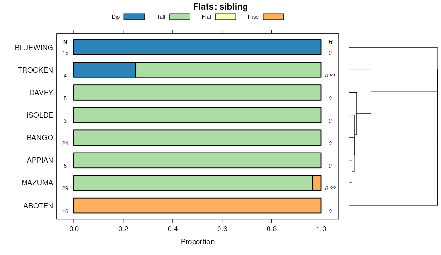
Hawsley-Ruhe-Bluewing association | 7047 | 1563 | 2427773 | 2w4dm | nv603 | 1971 | 1:24000 |
Hawsley-Gamgee association | 7043 | 472 | 2427782 | 2mh9k | nv603 | 1971 | 1:24000 |
Hawsley-Badland-Isolde association | 7052 | 191 | 2427775 | 2mh9b | nv603 | 1971 | 1:24000 |
Hawsley-Appian-Ruhe association | 7025 | 123 | 2427752 | 2w4dn | nv603 | 1971 | 1:24000 |
Trocken-Hawsley-Bluewing association | 7051 | 71 | 2427774 | 2mh99 | nv603 | 1971 | 1:24000 |
Hawsley-Isolde association | 7022 | 9631 | 2425493 | 2mdxq | nv625 | 1981 | 1:24000 |
Hough-Hawsley association | 7060 | 8854 | 2425557 | 2mdzs | nv625 | 1981 | 1:24000 |
Hawsley loamy sand, 2 to 8 percent slopes | 1072 | 6247 | 473873 | 2n9zz | nv625 | 1981 | 1:24000 |
Pirouette-Singatse-Hawsley association | 7201 | 5631 | 2425579 | 2mf0h | nv625 | 1981 | 1:24000 |
Hawsley-Gamgee association | 1073 | 5163 | 473874 | hx38 | nv625 | 1981 | 1:24000 |
Theon-Singatse-Hawsley association | 7202 | 5130 | 2425580 | 2tfnl | nv625 | 1981 | 1:24000 |
Hawsley-Piroutte-Isolde association | 7210 | 4566 | 2425581 | 2mf0k | nv625 | 1981 | 1:24000 |
Hawsley-Trocken association | 7049 | 1091 | 2425556 | 2mdzr | nv625 | 1981 | 1:24000 |
Bluewing-Hawsley association | 7075 | 782 | 2425567 | 2w4dr | nv625 | 1981 | 1:24000 |
Hawsley loamy fine sand, silty substratum, 0 to 2 percent slopes | 1074 | 753 | 473875 | hx39 | nv625 | 1981 | 1:24000 |
Hawsley-Playas complex | 1075 | 699 | 473876 | hx3b | nv625 | 1981 | 1:24000 |
Hawsley loamy sand, 8 to 15 percent slopes | 7088 | 369 | 2425571 | 2mf07 | nv625 | 1981 | 1:24000 |
Rawe-Perazzo-Hawsley association | 7087 | 238 | 2425568 | 2mf04 | nv625 | 1981 | 1:24000 |
Hawsley-Ruhe-Bluewing association | 7047 | 15254 | 474176 | 2w4dm | nv628 | 1980 | 1:24000 |
Hawsley loamy sand, 2 to 8 percent slopes | 7013 | 2028 | 2452471 | 2n9zz | nv628 | 1980 | 1:24000 |
Pirouette-Singatse-Hawsley association | 7201 | 723 | 2452481 | 2nb09 | nv628 | 1980 | 1:24000 |
Hawsley sand, 2 to 8 percent slopes | 1345 | 533 | 474180 | hxf4 | nv628 | 1980 | 1:24000 |
Trocken-Hawsley-Bluewing association | 7051 | 415 | 2452473 | 2nb01 | nv628 | 1980 | 1:24000 |
Hawsley-Bluewing association | 1347 | 263 | 474434 | 2rpfc | nv628 | 1980 | 1:24000 |
Hawsley-Badland-Isolde association | 7052 | 98 | 2452472 | 2nb00 | nv628 | 1980 | 1:24000 |
Hawsley fine sand, 2 to 4 percent slopes | 378 | 6679 | 474728 | hxzt | nv760 | 1994 | 1:24000 |
Hawsley-Labkey-Genegraf association | 452 | 28109 | 476311 | hzmw | nv761 | 1988 | 1:24000 |
Coldent-Hawsley-Mazuma association | 231 | 6696 | 476285 | hzm1 | nv761 | 1988 | 1:24000 |
Labkey-Hawsley-Granshaw association | 652 | 6652 | 476337 | hznq | nv761 | 1988 | 1:24000 |
Hawsley-Mazuma association | 462 | 3762 | 476317 | hzn2 | nv761 | 1988 | 1:24000 |
Mazuma-Hardhat-Hawsley association | 703 | 2812 | 476342 | hznw | nv761 | 1988 | 1:24000 |
Hawsley fine sand, 0 to 4 percent slopes | 451 | 1250 | 476310 | hzmv | nv761 | 1988 | 1:24000 |
Hawsley-Bluewing association | 453 | 1125 | 476312 | 2rpfc | nv761 | 1988 | 1:24000 |
Hawsley-Badland association | 456 | 931 | 476314 | hzmz | nv761 | 1988 | 1:24000 |
Hawsley-Ragtown association | 122 | 14052 | 475192 | hygs | nv769 | 1986 | 1:24000 |
Hawsley fine sand, 2 to 8 percent slopes | 121 | 6928 | 475190 | hygq | nv769 | 1986 | 1:24000 |
Hawsley sand, moderately wet, 0 to 2 percent slopes | 120 | 937 | 475187 | hygm | nv769 | 1986 | 1:24000 |
Hawsley loamy sand, 2 to 8 percent slopes | 140 | 54459 | 476438 | 2n9zz | nv770 | 1995 | 1:24000 |
Hawsley-Piroutte-Isolde association | 7210 | 18567 | 2425541 | 2mdz8 | nv770 | 1995 | 1:24000 |
Hawsley-Isolde association | 141 | 18156 | 476439 | hzs0 | nv770 | 1995 | 1:24000 |
Hawsley-Gamgee association | 143 | 8411 | 476441 | hzs2 | nv770 | 1995 | 1:24000 |
Patna-Hawsley-Juva association | 1120 | 8215 | 476405 | hzqx | nv770 | 1995 | 1:24000 |
Hawsley-Theon-Pirouette association | 144 | 7337 | 476442 | hzs3 | nv770 | 1995 | 1:24000 |
Isolde-Pirouette-Hawsley association | 172 | 6475 | 476464 | hzst | nv770 | 1995 | 1:24000 |
Hawsley-Appian-Ruhe association | 7025 | 5658 | 2452503 | 2w4dn | nv770 | 1995 | 1:24000 |
Pirouette-Hawsley association | 203 | 5641 | 476488 | hztl | nv770 | 1995 | 1:24000 |
Hawsley-Juva association | 146 | 5294 | 476444 | hzs5 | nv770 | 1995 | 1:24000 |
Bluewing-Hawsley association | 7075 | 5126 | 2425539 | 2w4dr | nv770 | 1995 | 1:24000 |
Bango-Hawsley association MLRA 27 | 7042 | 5034 | 2452502 | 2w36r | nv770 | 1995 | 1:24000 |
Pirouette-Singatse-Hawsley association | 7201 | 3855 | 2425540 | 2mdz7 | nv770 | 1995 | 1:24000 |
Hawsley-Celeton-Bluewing association | 147 | 3419 | 476445 | hzs6 | nv770 | 1995 | 1:24000 |
Hawsley-Biddleman-Mazuma association | 7090 | 1827 | 2425721 | 2mf52 | nv770 | 1995 | 1:24000 |
Hough-Hawsley association | 7060 | 435 | 2425538 | 2mdz5 | nv770 | 1995 | 1:24000 |
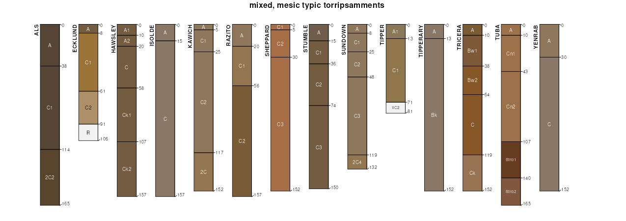
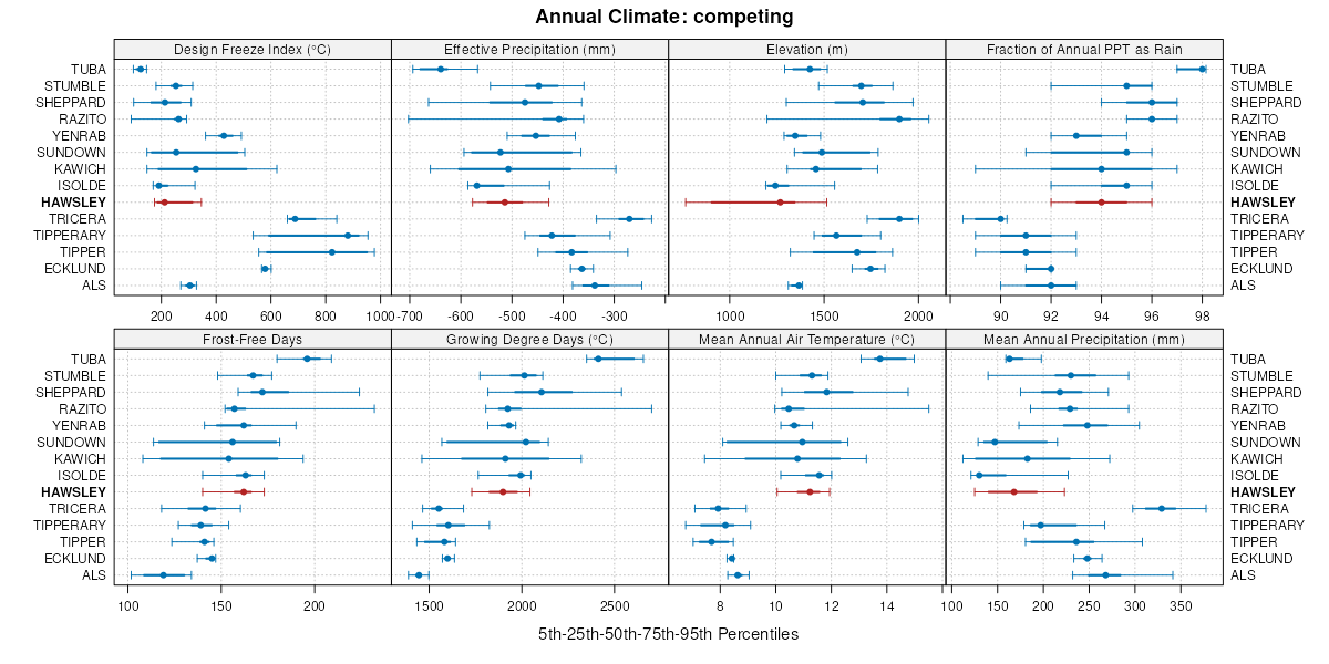
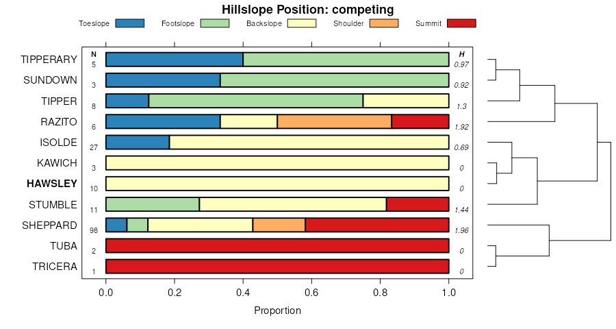
Dun Glen-Davey-Hawsley association | 160 | 6769 | 477397 | j0rx | nv771 | 1990 | 1:24000 |
Mazuma-Hawsley association | 1620 | 6166 | 477402 | j0s2 | nv771 | 1990 | 1:24000 |
Toulon-Mazuma-Hawsley association | 560 | 3996 | 477516 | j0wr | nv771 | 1990 | 1:24000 |
Hawsley association | 940 | 3711 | 477587 | j0z1 | nv771 | 1990 | 1:24000 |
Trocken-Mazuma-Hawsley association | 1581 | 2968 | 477395 | j0rv | nv771 | 1990 | 1:24000 |
Trocken-Hawsley association | 1068 | 759 | 477294 | j0nl | nv771 | 1990 | 1:24000 |
Hawsley sand, 2 to 8 percent slopes | 7072 | 60 | 2619431 | hxf4 | nv772 | 1985 | 1:24000 |
Hawsley loamy sand, 2 to 8 percent slopes | 7013 | 34404 | 2425491 | 2n9zz | nv774 | 1985 | 1:24000 |
Hough-Hawsley association | 7060 | 26694 | 2425586 | 2mf0q | nv774 | 1985 | 1:24000 |
Hawsley-Isolde association | 7022 | 14009 | 2425494 | 2mdxr | nv774 | 1985 | 1:24000 |
Theon-Singatse-Hawsley association | 7202 | 8835 | 2425607 | 2tfnl | nv774 | 1985 | 1:24000 |
Isolde-Appian-Hawsley association | 7085 | 5363 | 2425592 | 2mf0x | nv774 | 1985 | 1:24000 |
Isolde-Hawsley association | 1040 | 5307 | 476703 | j01j | nv774 | 1985 | 1:24000 |
Hawsley-Biddleman-Mazuma association | 7090 | 3713 | 2425596 | 2mf11 | nv774 | 1985 | 1:24000 |
Singatse-Hawsley association | 1094 | 3547 | 476711 | 2xdmr | nv774 | 1985 | 1:24000 |
Hawsley loamy sand, 8 to 15 percent slopes | 7088 | 3395 | 2425594 | 2mf0z | nv774 | 1985 | 1:24000 |
Luning-Hawsley-Bluewing association | 1875 | 3106 | 476822 | j05c | nv774 | 1985 | 1:24000 |
Bango-Hawsley complex, 0 to 4 percent slopes | 4250 | 2778 | 476981 | j0bh | nv774 | 1985 | 1:24000 |
Hawsley-Isolde-Slawmaster association | 7067 | 2256 | 2425588 | 2mf0s | nv774 | 1985 | 1:24000 |
Hawsley sand, 0 to 4 percent slopes | 1172 | 2241 | 476727 | j029 | nv774 | 1985 | 1:24000 |
Hawsley-Izo association | 1173 | 2096 | 476728 | j02b | nv774 | 1985 | 1:24000 |
Hawsley-Sodaspring-Singatse association | 7091 | 1983 | 2425597 | 2mf12 | nv774 | 1985 | 1:24000 |
Downeyville-Hawsley association | 4171 | 734 | 476954 | j09m | nv774 | 1985 | 1:24000 |
Hawsley-Bluewing association | 7080 | 623 | 2425591 | 2rpfc | nv774 | 1985 | 1:24000 |
Rawe-Perazzo-Hawsley association | 7087 | 313 | 2425593 | 2mf0y | nv774 | 1985 | 1:24000 |
Bluewing-Hawsley association | 7075 | 168 | 2425590 | 2w4dr | nv774 | 1985 | 1:24000 |
Pirouette-Singatse-Hawsley association | 7201 | 70 | 2425729 | 2mf5b | nv774 | 1985 | 1:24000 |
Hawsley-Isolde association | 1161 | 30167 | 475419 | hyq3 | nv777 | 1993 | 1:24000 |
Hawsley fine sand, 0 to 4 percent slopes 1/ | 1160 | 17621 | 475418 | hyq2 | nv777 | 1993 | 1:24000 |
Davey-Hawsley association | 205 | 10107 | 475627 | hyxt | nv777 | 1993 | 1:24000 |
Hawsley-Davey-Mazuma association | 1162 | 3726 | 475420 | hyq4 | nv777 | 1993 | 1:24000 |
Hawsley fine sand, 4 to 15 percent slopes | 1167 | 3322 | 475424 | hyq8 | nv777 | 1993 | 1:24000 |
Essal-Isolde-Hawsley association | 305 | 3222 | 475674 | hyzb | nv777 | 1993 | 1:24000 |
Hawsley-Davey-Essal association | 1168 | 2874 | 475425 | hyq9 | nv777 | 1993 | 1:24000 |
Hawsley-Soughe-Panlee association | 1169 | 1542 | 475426 | hyqb | nv777 | 1993 | 1:24000 |
Luning-Hawsley-Bluewing association | 2110 | 4179 | 480845 | j4c4 | nv781 | 1994 | 1:24000 |
Singatse-Hawsley association | 1076 | 1112 | 480676 | 2xdmr | nv781 | 1994 | 1:24000 |
Isolde-Hawsley association | 1510 | 453 | 480783 | j494 | nv781 | 1994 | 1:24000 |