| Cherry, Havrelon, and Trembles soils, 0 to 4 percent slopes, occasionally flooded | 215B | 1422 | 1487328 | 1lxpb | mt021 | 1971 | 1:24000 |
Havrelon silt loam, 0 to 2 percent slopes | 36A | 1108 | 1487385 | 1lxr5 | mt021 | 1971 | 1:24000 |
Havrelon silt loam, 2 to 4 percent slopes | 36B | 301 | 1487386 | 1lxr6 | mt021 | 1971 | 1:24000 |
Havrelon loam, 0 to 2 percent slopes, occasionally flooded | E4121A | 382 | 342247 | 1vzvv | mt025 | 1991 | 1:24000 |
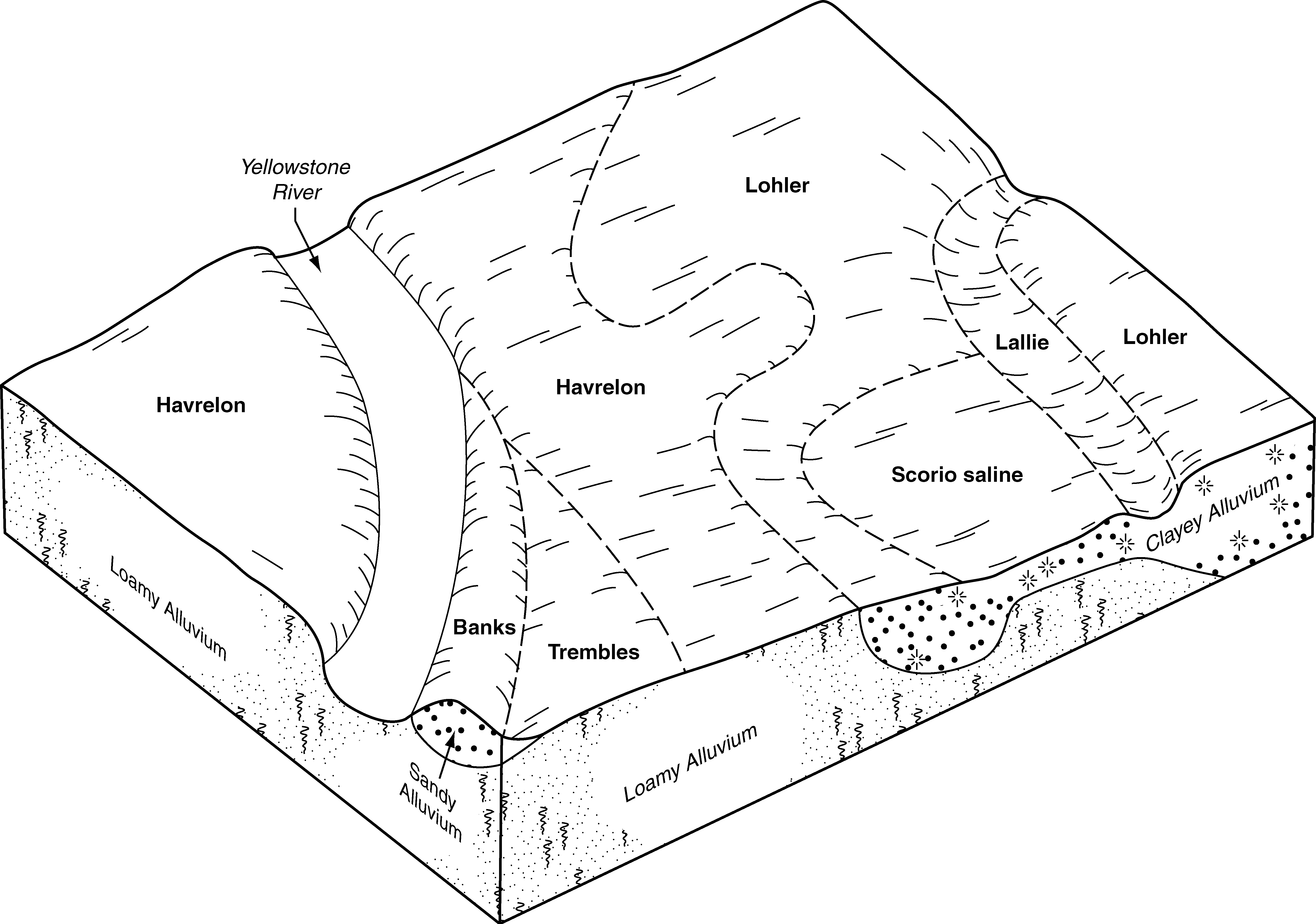
Cherry-Havrelon-Trembles complex, 0 to 2 percent slopes | 45 | 17326 | 344408 | ckcy | mt055 | 1981 | 1:24000 |
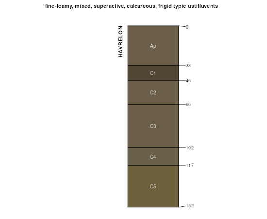
Havrelon loam | 86 | 8624 | 344453 | ckfd | mt055 | 1981 | 1:24000 |
Havrelon silty clay loam, protected | 90 | 3044 | 344458 | ckfk | mt055 | 1981 | 1:24000 |
Havrelon loam, saline | 88 | 2795 | 344455 | ckfg | mt055 | 1981 | 1:24000 |
Havrelon loam, protected | 87 | 1388 | 344454 | ckff | mt055 | 1981 | 1:24000 |
Havrelon silty clay loam | 89 | 1298 | 344456 | ckfh | mt055 | 1981 | 1:24000 |
Cherry, Havrelon, and Trembles soils, occasionally flooded | Ch | 25793 | 345330 | clbp | mt083 | 1973 | 1:24000 |
Havrelon loam, 0 to 2 percent slopes, occasionally flooded | E4121A | 10805 | 345336 | 1vzvv | mt083 | 1973 | 1:24000 |
Havrelon silt loam, 0 to 1 percent slopes | HaA | 9301 | 3079040 | clbw | mt083 | 1973 | 1:24000 |
Havrelon silty clay loam, 0 to 2 percent slopes, occasionally flooded | E4129A | 5986 | 345338 | 1vzvz | mt083 | 1973 | 1:24000 |
Havrelon silty clay loam | Hb | 2723 | 3079041 | clby | mt083 | 1973 | 1:24000 |
Havrelon silt loam, 1 to 4 percent slopes | HaB | 523 | 345337 | clbx | mt083 | 1973 | 1:24000 |
Havrelon silt loam | Ha | 22442 | 348850 | cq07 | mt091 | 1971 | 1:24000 |
Havrelon silt loam, saline | Hb | 4225 | 348851 | cq08 | mt091 | 1971 | 1:24000 |
Havrelon, rarely flooded-Macar complex, 0 to 4 percent slopes | 609B | 3 | 2694671 | 21m2w | mt602 | 1963 | 1:20000 |
Havrelon loam, 0 to 4 percent slopes, rarely flooded | 606B | 3 | 2694670 | 21q27 | mt602 | 1963 | 1:20000 |
Havrelon loam, 0 to 4 percent slopes, rarely flooded | 606B | 2865 | 1898044 | 21q27 | mt624 | 2021 | 1:24000 |
Lohler-Havrelon complex, 0 to 2 percent slopes, rarely flooded | 607A | 1843 | 1898122 | 21q4r | mt624 | 2021 | 1:24000 |
Havrelon, rarely flooded-Macar complex, 0 to 4 percent slopes | 609B | 1568 | 1895181 | 21m2w | mt624 | 2021 | 1:24000 |
Cabba-Haverlon complex, 0 to 25 percent slopes | 613E | 778 | 1902630 | 21vv5 | mt624 | 2021 | 1:24000 |
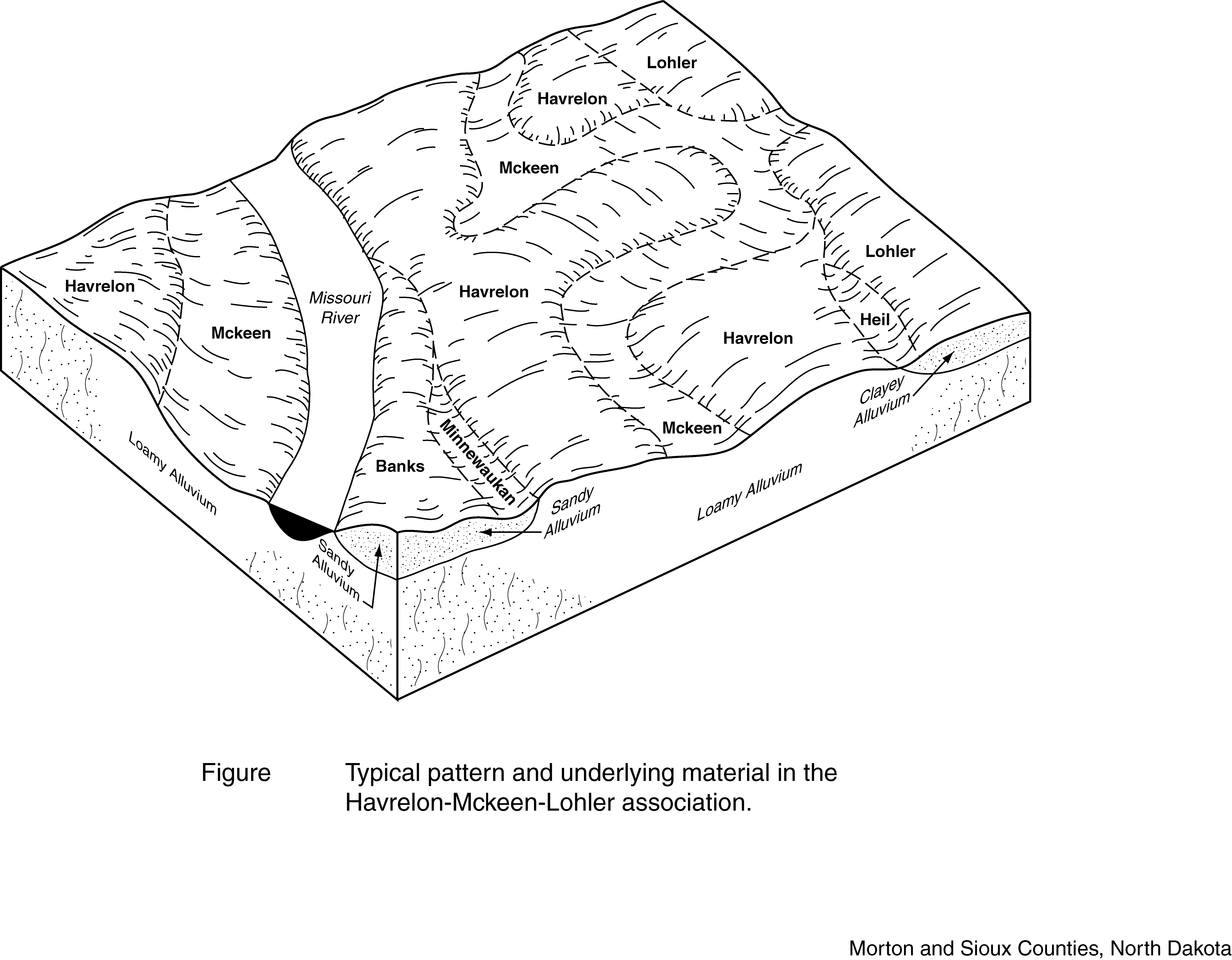
Farland and Havrelon soils, 4 to 8 percent slopes | Fm | 39140 | 347852 | cnz1 | mt643 | 1967 | 1:20000 |
Havrelon-Trembles complex, 0 to 2 percent slopes | 28 | 18041 | 348231 | cpc8 | mt661 | 1982 | 1:24000 |
Havrelon silt loam, protected, 0 to 2 percent slopes | 27 | 17864 | 348230 | cpc7 | mt661 | 1982 | 1:24000 |
Havrelon-Trembles complex, protected, 0 to 2 percent slopes | 29 | 15230 | 348232 | cpc9 | mt661 | 1982 | 1:24000 |
Havrelon loam, 0 to 2 percent slopes, occasionally flooded | 26 | 11469 | 348229 | 1vzvv | mt661 | 1982 | 1:24000 |
Cabba-Chama-Havrelon, occasionally flooded complex, 2 to 70 percent slopes | E4190F | 20 | 2755663 | 2r4j4 | nd001 | 1983 | 1:20000 |
Havrelon loam, 0 to 2 percent slopes, occasionally flooded | E4121A | 2 | 2755658 | 1vzvv | nd001 | 1983 | 1:20000 |
Havrelon loam, 0 to 2 percent slopes, occasionally flooded | E4121A | 301 | 2563561 | 1vzvv | nd011 | 1969 | 1:20000 |
Cabba-Chama-Havrelon, occasionally flooded complex, 2 to 70 percent slopes | E4190F | 50 | 2758458 | 2r4j4 | nd011 | 1969 | 1:20000 |
Havrelon loam, 0 to 2 percent slopes, occasionally flooded | E4121A | 7907 | 2661702 | 1vzvv | nd015 | 1967 | 1:20000 |
Havrelon silty clay loam, 0 to 2 percent slopes, occasionally flooded | E4129A | 6397 | 2661703 | 1vzvz | nd015 | 1967 | 1:20000 |
Havrelon fine sandy loam, 0 to 2 percent slopes, occasionally flooded | E4119A | 2464 | 2661679 | cdqb | nd015 | 1967 | 1:20000 |
Havrelon loam, clayey substratum, 0 to 2 percent slopes, occasionally flooded | E4124A | 668 | 2661716 | 2q63n | nd015 | 1967 | 1:20000 |
Havrelon loam, 0 to 2 percent slopes, occasionally flooded | E4121A | 1003 | 2707242 | 1vzvv | nd025 | 1981 | 1:20000 |
Cabba-Chama-Havrelon, occasionally flooded complex, 2 to 70 percent slopes | E4190F | 320 | 2707248 | 2r4j4 | nd025 | 1981 | 1:20000 |
Havrelon-Fluvaquents complex, channeled, 0 to 2 percent slopes, frequently flooded | E4123A | 79 | 2707243 | 1vzvw | nd025 | 1981 | 1:20000 |
Havrelon-Fluvaquents complex, channeled, 0 to 2 percent slopes, frequently flooded | E4123A | 3666 | 2707307 | 1vzvw | nd033 | 1985 | 1:24000 |
Cabba-Chama-Havrelon, occasionally flooded complex, 2 to 70 percent slopes | E4190F | 317 | 2759752 | 2r4j4 | nd033 | 1985 | 1:24000 |
Cherry-Lambert, gullied-Havrelon, occasionally flooded complex, 0 to 6 percent slopes | E3235B | 215 | 2759750 | d32s | nd033 | 1985 | 1:24000 |
Cabba-Chama-Havrelon, occasionally flooded complex, 2 to 70 percent slopes | E4190F | 24 | 2525844 | 2r4j4 | nd037 | 1985 | 1:20000 |
Havrelon loam, 0 to 2 percent slopes, occasionally flooded | E4121A | 8 | 2525847 | 1vzvv | nd037 | 1985 | 1:20000 |
Cabba-Chama-Havrelon, occasionally flooded complex, 2 to 70 percent slopes | E4190F | 74 | 2525818 | 2r4j4 | nd041 | 1986 | 1:20000 |
Cabba-Chama-Havrelon, occasionally flooded complex, 2 to 70 percent slopes | E4190F | 27879 | 2699351 | 2r4j4 | nd053 | 2003 | 1:24000 |
Havrelon silty clay, slightly wet, 0 to 2 percent slopes, occasionally flooded | E4132A | 6721 | 2699343 | cdtw | nd053 | 2003 | 1:24000 |
Havrelon loam, slightly wet, 0 to 2 percent slopes, occasionally flooded | E4122A | 6321 | 2699341 | 1sdwr | nd053 | 2003 | 1:24000 |
Havrelon loam, 0 to 2 percent slopes, occasionally flooded | E4121A | 2796 | 2699340 | 1vzvv | nd053 | 2003 | 1:24000 |
Cherry-Lambert, gullied-Havrelon, occasionally flooded complex, 0 to 6 percent slopes | E3235B | 1235 | 2715100 | d32s | nd053 | 2003 | 1:24000 |
Havrelon silty clay loam, saline, 0 to 1 percent slopes, occasionally flooded | E4128A | 266 | 2699342 | 1vzvy | nd053 | 2003 | 1:24000 |
Havrelon silty clay loam, 0 to 2 percent slopes, occasionally flooded | E4129A | 127 | 2759723 | 1vzvz | nd053 | 2003 | 1:24000 |
Havrelon silty clay loam, 0 to 2 percent slopes, occasionally flooded | E4129A | 4749 | 2662464 | 1vzvz | nd055 | 1974 | 1:20000 |
Havrelon fine sandy loam, 0 to 2 percent slopes, occasionally flooded | E4119A | 4561 | 2662440 | cdqb | nd055 | 1974 | 1:20000 |
Havrelon silty clay loam, 0 to 2 percent slopes, occasionally flooded | E4129A | 2550 | 2699271 | 1vzvz | nd057 | 1976 | 1:20000 |
Havrelon loam, 0 to 2 percent slopes, occasionally flooded | E4121A | 2397 | 2699270 | 1vzvv | nd057 | 1976 | 1:20000 |
Havrelon loam, 0 to 2 percent slopes, occasionally flooded | E4121A | 4777 | 2699171 | 1vzvv | nd059 | 1998 | 1:20000 |
Havrelon loam, somewhat poorly drained, 0 to 2 percent slopes, occasionally flooded | E4131A | 2891 | 2699172 | 2r4f0 | nd059 | 1998 | 1:20000 |
Havrelon fine sandy loam, 0 to 2 percent slopes, occasionally flooded | E4119A | 1288 | 2699169 | cdqb | nd059 | 1998 | 1:20000 |
Havrelon fine sandy loam, somewhat poorly drained, 0 to 2 percent slopes, occasionally flooded | E4120A | 722 | 2699170 | cdqp | nd059 | 1998 | 1:20000 |
Havrelon silty clay loam, 0 to 2 percent slopes, occasionally flooded | E4129A | 4154 | 2525993 | 1vzvz | nd065 | 1971 | 1:20000 |
Havrelon loam, 0 to 2 percent slopes, occasionally flooded | E4121A | 3416 | 2525992 | 1vzvv | nd065 | 1971 | 1:20000 |
Havrelon loam, somewhat poorly drained, 0 to 2 percent slopes, occasionally flooded | E4131A | 1258 | 2755716 | 2r4f0 | nd065 | 1971 | 1:20000 |
Havrelon-Fluvaquents complex, channeled, 0 to 2 percent slopes, frequently flooded | E4123A | 25 | 2759704 | 1vzvw | nd085 | 1992 | 1:24000 |
Havrelon loam, 0 to 2 percent slopes, occasionally flooded | E4121A | 416 | 2715858 | 1vzvv | nd087 | 1974 | 1:20000 |
Havrelon loam, 0 to 2 percent slopes, occasionally flooded | E4121A | 4544 | 2716006 | 1vzvv | nd089 | 1965 | 1:20000 |
Cabba-Chama-Havrelon, occasionally flooded complex, 2 to 70 percent slopes | E4190F | 4205 | 2716018 | 2r4j4 | nd089 | 1965 | 1:20000 |
Havrelon-Fluvaquents complex, channeled, 0 to 2 percent slopes, frequently flooded | E4123A | 2685 | 2716007 | 1vzvw | nd089 | 1965 | 1:20000 |
Havrelon, wooded-Fluvaquents complex, channeled, 0 to 2 percent slopes, frequently flooded | E4125A | 1122 | 2716008 | 1vzvx | nd089 | 1965 | 1:20000 |
Havrelon silty clay loam, 0 to 2 percent slopes, occasionally flooded | E4129A | 292 | 2716010 | 1vzvz | nd089 | 1965 | 1:20000 |
Havrelon silty clay loam, saline, 0 to 1 percent slopes, occasionally flooded | E4128A | 125 | 2716009 | 1vzvy | nd089 | 1965 | 1:20000 |
Havrelon loam, slightly wet, 0 to 2 percent slopes, occasionally flooded | E4122A | 2633 | 2662557 | 1sdwr | nd105 | 1993 | 1:24000 |
Havrelon loam, slightly wet, 0 to 2 percent slopes | 910 | 22 | 339174 | ccy3 | nd105 | 1993 | 1:24000 |
Havrelon loam, 0 to 2 percent slopes, occasionally flooded | E4121A | 3 | 2662575 | 1vzvv | nd105 | 1993 | 1:24000 |
Havrelon loam, channeled | Hg | 8223 | 356169 | cymb | sd031 | 1986 | 1:24000 |
Havrelon loam, terrace | Hn | 5646 | 356170 | cymc | sd031 | 1986 | 1:24000 |
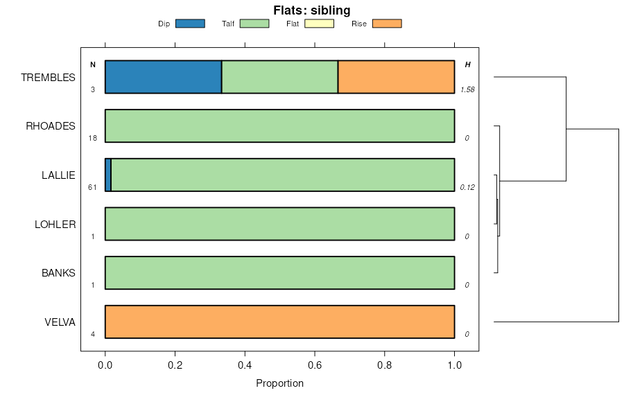
Havrelon-Rhoades loams, 0 to 4 percent slopes | HrA | 2631 | 356171 | cymd | sd031 | 1986 | 1:24000 |
Havrelon loam, 0 to 2 percent slopes, occasionally flooded | Hf | 2022 | 356168 | 1vzvv | sd031 | 1986 | 1:24000 |
Lohler and Havrelon soils | Lp | 8967 | 354203 | cwkx | sd041 | 1972 | 1:24000 |
Trembles-Havrelon complex | Th | 4595 | 354247 | cwmb | sd041 | 1972 | 1:24000 |
Havrelon, stony-Winetti families complex, 2 to 8 percent slopes, occasionally flooded | 7 | | 3312893 | 30gx7 | ut645 | | 1:24000 |