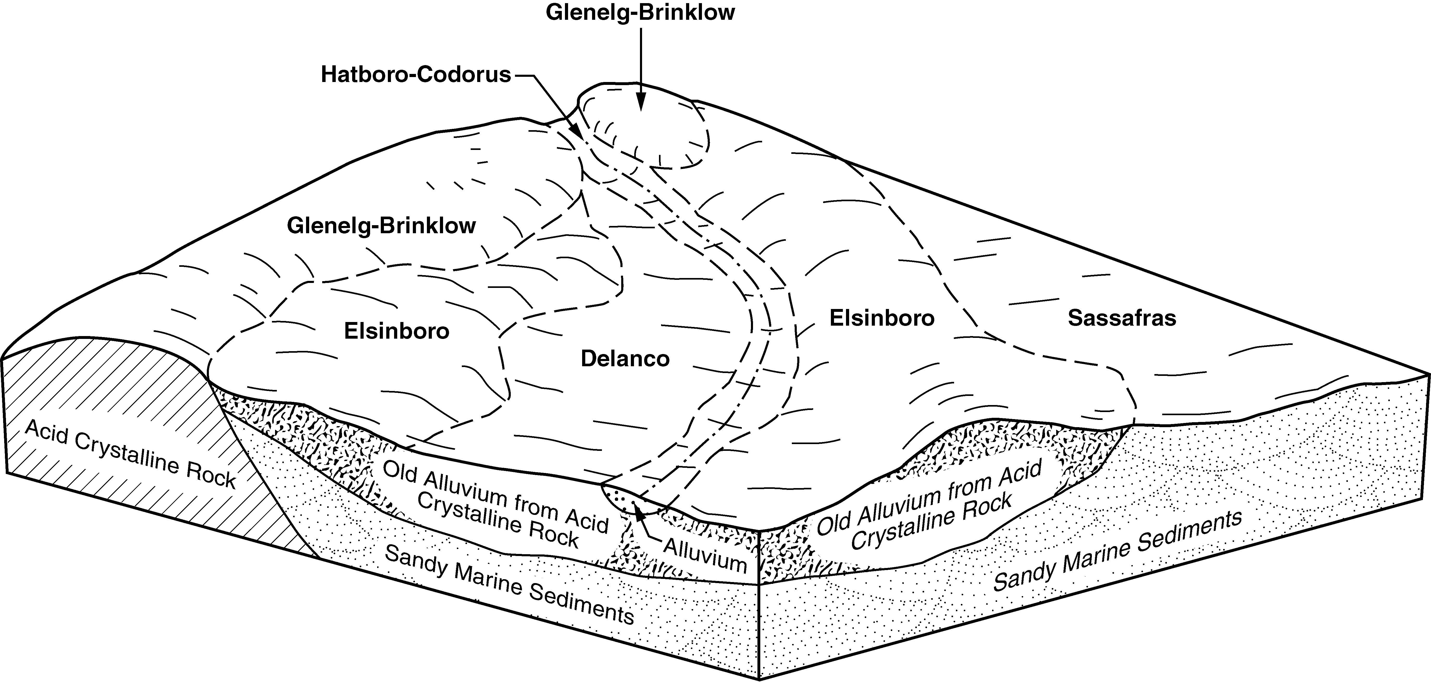
| Hatboro-Codorus complex, 0 to 3 percent slopes, frequently flooded | Hw | 3553 | 2479854 | 2p7h9 | de003 | 2009 | 1:24000 |
Delanco-Codorus-Hatboro complex, 0 to 8 percent slopes, flooded | DcB | 2507 | 2479860 | 2p7hh | de003 | 2009 | 1:24000 |
Hatboro silt loam, 0 to 3 percent slopes, frequently flooded | Ht | 351 | 2479853 | 2p7h8 | de003 | 2009 | 1:24000 |
Codorus and Hatboro soils, 0 to 2 percent slopes, frequently flooded | CHA | 1732 | 137733 | 4mb0 | md003 | 2003 | 1:12000 |
Hatboro silt loams, 0 to 3 percent slopes | HbA | 5002 | 2403682 | 2lp74 | md005 | 2010 | 1:12000 |
Hatboro silt loam, 0 to 3 percent slopes | HaA | 7122 | 2495836 | 2ptkd | md013 | 2010 | 1:12000 |
Hatboro-Codorus complex, 0 to 3 percent slopes, flooded | Hw | 3338 | 2440699 | 2mxr7 | md015 | 2009 | 1:12000 |
Hatboro silt loam, 0 to 3 percent slopes, frequently flooded | Ht | 1538 | 2440698 | 2mxr6 | md015 | 2009 | 1:12000 |
Delanco-Codorus-Hatboro complex, 0 to 8 percent slopes, flooded | DcB | 366 | 2440708 | 2mxrj | md015 | 2009 | 1:12000 |
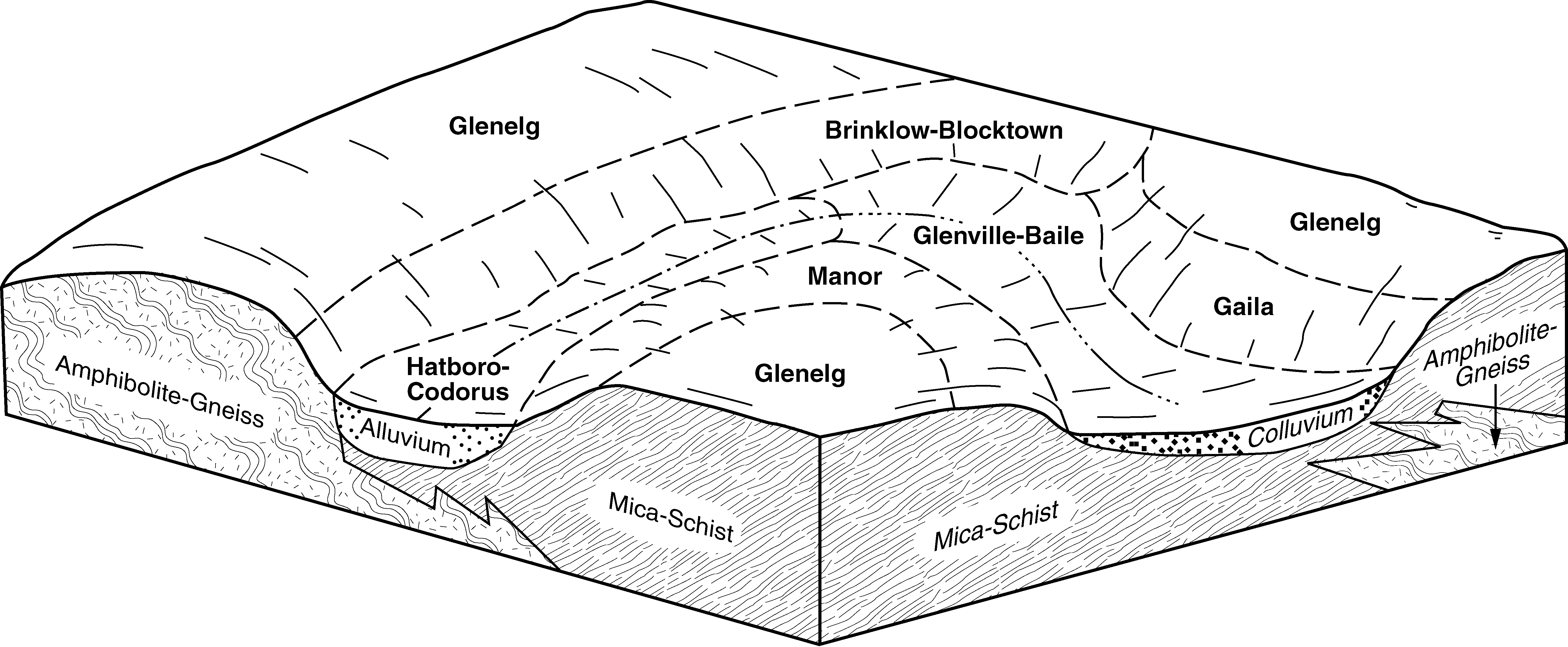
Codorus and Hatboro silt loams, 0 to 3 percent slopes | CgA | 6347 | 534793 | kyhd | md021 | 2001 | 1:12000 |
Hatboro-Codorus silt loams, 0 to 3 percent slopes | HdA | 4246 | 534818 | kyj6 | md021 | 2001 | 1:12000 |
Foxville and Hatboro soils, 0 to 3 percent slopes | FxA | 1933 | 534811 | kyhz | md021 | 2001 | 1:12000 |
Codorus and Hatboro silt loams, 0 to 3 percent slopes | Co | 5055 | 792809 | vlzh | md027 | 2004 | 1:12000 |
Hatboro-Codorus silt loams, 0 to 3 percent slopes | Ha | 4167 | 793006 | vm5v | md027 | 2004 | 1:12000 |
Codorus and Hatboro soils, 0 to 2 percent slopes, frequently flooded | Cp | 245 | 1479397 | 1lnfh | md027 | 2004 | 1:12000 |
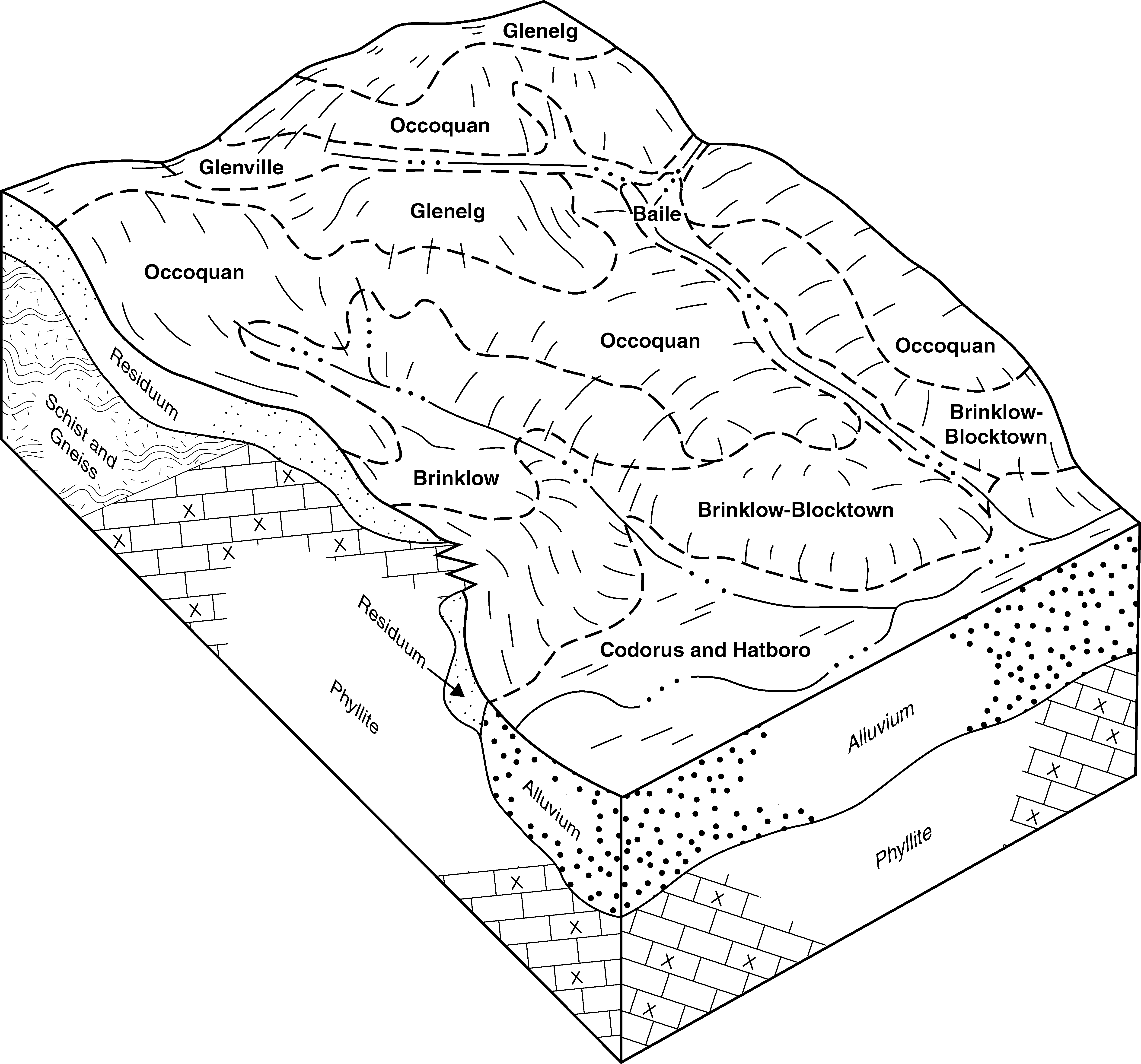
Hatboro silt loam, 0 to 3 percent slopes, frequently flooded | 54A | 10772 | 533647 | kx9f | md031 | 1989 | 1:15840 |
Codorus and Hatboro soils, frequently flooded | CF | 2501 | 2455297 | 2ndy4 | md033 | 2009 | 1:12000 |
Codorus-Hatboro-Urban land complex, frequently flooded | Ch | 1230 | 2455298 | 2ndy5 | md033 | 2009 | 1:12000 |
Hatboro silt loam | Hh | 197 | 534406 | ky2x | md043 | 1998 | 1:12000 |
Foxville and Hatboro soils | FO | 113 | 534327 | ky0c | md043 | 1998 | 1:12000 |
Hatboro-Codorus complex, 0 to 3 percent slopes, frequently flooded | 50A | 783 | 533886 | 2w06d | md510 | 1993 | 1:12000 |
Hatboro-Codorus complex, 0 to 3 percent slopes, frequently flooded | HcA | 3309 | 533353 | 2w06d | md600 | 1972 | 1:15840 |
Hatboro silt loam | Hb | 3266 | 533396 | kx1b | md600 | 1972 | 1:15840 |
Hatboro loam, 0 to 2 percent slopes, frequently flooded | HaA | 211 | 2390337 | 2l7bn | nc003 | 1988 | 1:24000 |
Hatboro sandy loam, 0 to 2 percent slopes, frequently flooded | HaA | 326 | 117008 | 3xrg | nc023 | 2000 | 1:24000 |
Hatboro loam, 0 to 2 percent slopes, frequently flooded | HaA | 1154 | 2679240 | 2r935 | nc027 | 2012 | 1:12000 |
Hatboro loam, 0 to 2 percent slopes, frequently flooded | HaA | 265 | 2431418 | 2mm2v | nc035 | 1969 | 1:15840 |
Hatboro loam, 0 to 2 percent slopes, frequently flooded | HaA | 5300 | 2433806 | 2mpkw | nc067 | 1970 | 1:15840 |
Hatboro loam, 0 to 2 percent slopes, frequently flooded | HdA | 2537 | 2433439 | 2mp61 | nc081 | 1975 | 1:20000 |
Hatboro loam | Ha | 1849 | 546863 | lc1r | nc089 | 1974 | 1:20000 |
Hatboro loam, 0 to 2 percent slopes, frequently flooded | HaA | 315 | 2424478 | 2mcvz | nc097 | 2011 | 1:12000 |
Codorus and Hatboro soils, 0 to 2 percent slopes, frequently flooded | CoA | 3541 | 2439285 | 2mw8m | nc145 | 1987 | 1:24000 |
Hatboro silt loam, 0 to 2 percent slopes, frequently flooded, long duration | HbA | 3897 | 2389965 | 2l6yn | nc157 | 1983 | 1:24000 |
Hatboro loam, 0 to 2 percent slopes, frequently flooded | HaA | 288 | 1427630 | 1jxkl | nc171 | 2005 | 1:24000 |
Hatboro loam, 0 to 2 percent slopes, frequently flooded | HaA | 571 | 2389075 | 2l60y | nc193 | 1993 | 1:24000 |
Hatboro soils, 0 to 2 percent slopes, frequently flooded | HsA | 1022 | 2398012 | 2lhb7 | nc197 | 1960 | 1:15840 |
Hatboro loam, 0 to 2 percent slopes, frequently flooded | HaA | 561 | 2398014 | 2lhb9 | nc197 | 1960 | 1:15840 |
Hatboro-Codorus complex, 0 to 3 percent slopes, frequently flooded | HcuAt | 2732 | 1423987 | 2w06g | nj019 | 1970 | 1:24000 |
Hatboro-Codorus complex, 0 to 3 percent slopes, frequently flooded | HcuAt | 2825 | 1403680 | 2w06g | nj021 | 1969 | 1:24000 |
Hatboro-Codorus complex, 0 to 3 percent slopes, frequently flooded | HcuAt | 238 | 1395411 | 2w06g | nj023 | 1985 | 1:24000 |
Hatboro-Codorus complex, 0 to 3 percent slopes, frequently flooded | HcuAt | 4399 | 1444035 | 2w06g | nj027 | 1974 | 1:24000 |
Hatboro-Codorus complex, 0 to 3 percent slopes, frequently flooded | HcuAt | 2069 | 1404987 | 2w06g | nj035 | 1972 | 1:24000 |
Hatboro-Codorus complex, 0 to 3 percent slopes, frequently flooded | HcuAt | 1226 | 1452661 | 2w06g | nj039 | 1989 | 1:24000 |
Hatboro-Codorus complex, 0 to 3 percent slopes, frequently flooded | HcuAt | 38 | 1147481 | 2w06g | nj041 | 2007 | 1:12000 |
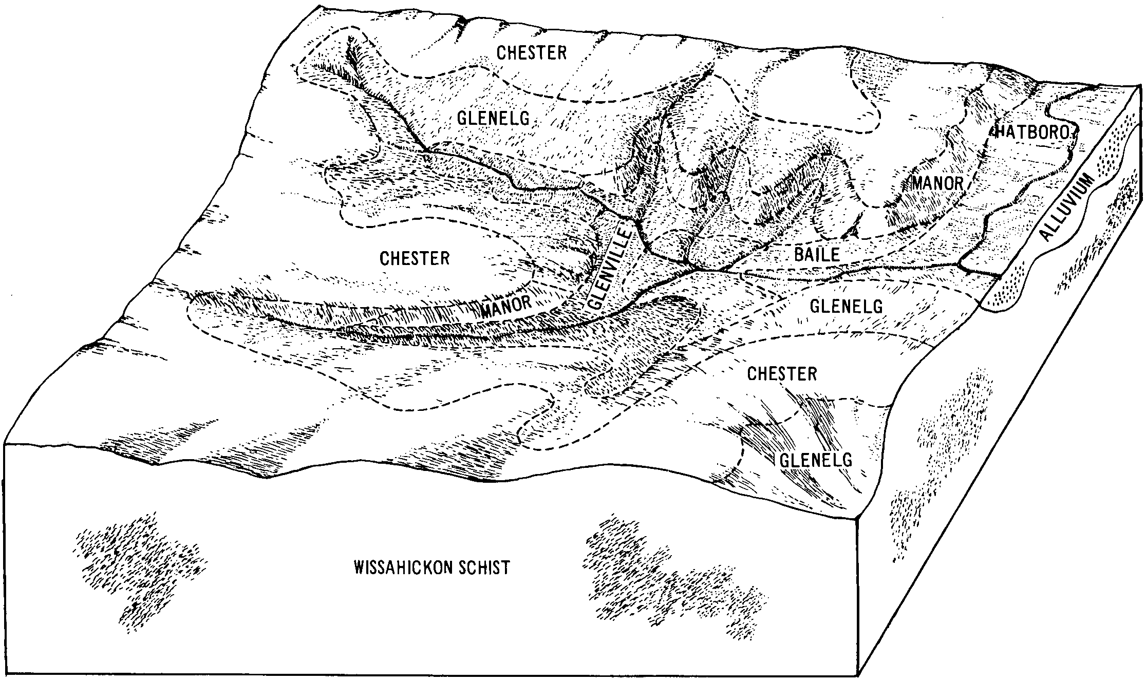
Hatboro silt loam | Hc | 5194 | 545594 | l9qt | pa001 | 1991 | 1:24000 |
Hatboro silt loam | Ha | 4848 | 543651 | l7q4 | pa017 | 1997 | 1:24000 |
Hatboro-Codorus complex, 0 to 3 percent slopes, frequently flooded | HbA | 1258 | 543637 | 2w06g | pa017 | 1997 | 1:24000 |
Nanticoke-Hatboro silt loams | Na | 604 | 543686 | l7r8 | pa017 | 1997 | 1:24000 |
Hatboro silt loam | Ha | 12873 | 1486410 | 1lwqq | pa029 | 2008 | 1:24000 |
Urban land-Hatboro complex | Uro | 169 | 1612038 | 1r3g7 | pa029 | 2008 | 1:24000 |
Hatboro silt loam | Hc | 9 | 699216 | rglc | pa041 | 1980 | 1:15840 |
Hatboro silt loam, 0 to 3 percent slopes, frequently flooded | HaA | 3347 | 2396183 | 30cgm | pa045 | 2023 | 1:12000 |
Hatboro silt loam | Hm | 135 | 545150 | l98h | pa055 | 1999 | 1:24000 |
Hatboro silt loam | Ha | 1953 | 541182 | l54h | pa091 | 2008 | 1:12000 |
Hatboro-Codorus complex, 0 to 3 percent slopes, frequently flooded | HbA | 180 | 543276 | 2w06g | pa095 | 2007 | 1:12000 |
Hatboro silt loam | Ha | 771 | 1479519 | 1lnkf | pa101 | 1971 | 1:15840 |
Hatboro-Codorus complex, 0 to 3 percent slopes, frequently flooded | HbA | 113 | 1479506 | 2w06g | pa101 | 1971 | 1:15840 |
Hatboro silt loam | Hc | 1775 | 542864 | l6wr | pa133 | 1990 | 1:24000 |
Hatboro loam, occasionally flooded | Ht | 1154 | 526538 | knx3 | tn091 | 2000 | 1:24000 |
Hatboro silt loam, frequently flooded | Hu | 15 | 560975 | ltqz | tn091 | 2000 | 1:24000 |
Hatboro silt loam, 0 to 2 percent slopes, occasionally flooded | 95 | 3550 | 516503 | 2v7kb | va003 | 1981 | 1:15840 |
Hatboro sandy loam, 0 to 3 percent slopes, frequently flooded | 1A | 21 | 123048 | 4419 | va013 | 2002 | 1:24000 |
Codorus-Hatboro complex, 0 to 3 percent slopes, frequently flooded | 2A | 15 | 123049 | 441b | va013 | 2002 | 1:24000 |
Codorus-Hatboro complex, 0 to 3 percent slopes, frequently flooded | 12A | 20129 | 2479379 | 2p6zz | va029 | 2010 | 1:24000 |
Hatboro loam, 0 to 2 percent slopes, frequently flooded | 21A | 2520 | 2479411 | 2p710 | va029 | 2010 | 1:24000 |
Hatboro silt loam | Ha | 9341 | 519216 | kf8x | va035 | 1965 | 1:15840 |
Codorus-Hatboro silt loams | Cs | 840 | 519201 | kf8f | va035 | 1965 | 1:15840 |
Hatboro-Toxaway silt loams | Hb | 674 | 519217 | kf8y | va035 | 1965 | 1:15840 |
Codorus and Hatboro soils, 0 to 2 percent slopes, frequently flooded | 10A | 1360 | 1726302 | 1vyc5 | va047 | 2006 | 1:24000 |
Codorus and Hatboro soils, 0 to 2 percent slopes, occasionally flooded | 30A | 12165 | 2250319 | 2fjmy | va059 | 2007 | 1:12000 |
Hatboro silt loam, 0 to 2 percent slopes, frequently flooded | 49A | 1103 | 2250382 | 2fjpz | va059 | 2007 | 1:12000 |
Wheaton-Hatboro complex, 0 to 2 percent slopes, frequently flooded | 106A | 47 | 2250559 | 2fjwp | va059 | 2007 | 1:12000 |
Hatboro silt loam, 0 to 2 percent slopes, frequently flooded | 4A | 5202 | 1895246 | 21m4z | va061 | 2006 | 1:12000 |
Hatboro sandy loam, 0 to 3 percent slopes, frequently flooded | 26A | 6581 | 1914759 | 228gf | va063 | 2007 | 1:24000 |
Hatboro sandy loam, 0 to 3 percent slopes, frequently flooded | 32A | 3720 | 516749 | kbqb | va077 | 2006 | 1:24000 |
Hatboro loam | Hb | 1900 | 516894 | kbw0 | va079 | 1983 | 1:15840 |
Codorus and Hatboro soils, 0 to 2 percent slopes, frequently flooded | 14A | 22831 | 1472805 | 1lfkv | va083 | 2004 | 1:24000 |
Hatboro loam, 0 to 2 percent slopes, frequently flooded | 4A | 3318 | 642010 | pk20 | va107 | 2006 | 1:12000 |
Hatboro-Codorus complex, 0 to 3 percent slopes, frequently flooded | Ac | 445 | 516915 | 2w06d | va113 | 1967 | 1:15840 |
Hatboro loam, 0 to 2 percent slopes, frequently flooded | 21A | 539 | 136946 | 4lhm | va125 | 1992 | 1:24000 |
Hatboro-Codorus complex, 0 to 3 percent slopes, frequently flooded | Mx | 4896 | 119882 | 2w06d | va137 | 1966 | 1:15840 |
Hatboro silt loam, 0 to 2 percent slopes, frequently flooded | We | 1009 | 119941 | 2zhh7 | va137 | 1966 | 1:15840 |
Hatboro loam, 0 to 2 percent slopes, frequently flooded | 29A | 878 | 1473804 | 1lgm2 | va141 | 2008 | 1:24000 |
Hatboro silt loam, 0 to 2 percent slopes, frequently flooded | 41A | 1723 | 120010 | 2yztg | va143 | 1989 | 1:24000 |
Hatboro-Codorus complex, 0 to 2 percent slopes | 27A | 3742 | 521170 | kh9y | va153 | 1985 | 1:15840 |
Hatboro silt loam, 0 to 2 percent slopes | 26A | 322 | 521169 | kh9x | va153 | 1985 | 1:15840 |
Hatboro-Codorus complex, 0 to 3 percent slopes, frequently flooded | Ad | 1654 | 517392 | 2w06d | va157 | 1958 | 1:20000 |
Codorus and Hatboro soils, 0 to 2 percent slopes, occasionally flooded | 30A | 229 | 1912968 | 226ln | va510 | 2007 | 1:12000 |
Hatboro silt loam, 0 to 2 percent slopes, occasionally flooded | 95 | 7 | 2496453 | 2v7kb | va540 | 2011 | 1:24000 |
Codorus and Hatboro soils, 0 to 2 percent slopes, occasionally flooded | 30A | 76 | 1907882 | 2219l | va600 | 2007 | 1:12000 |
Hatboro silt loam, 0 to 2 percent slopes, frequently flooded | 49A | 1 | 1912937 | 226kn | va600 | 2007 | 1:12000 |
Codorus and Hatboro soils, 0 to 2 percent slopes, occasionally flooded | 30A | 11 | 1907837 | 22184 | va610 | 2007 | 1:12000 |