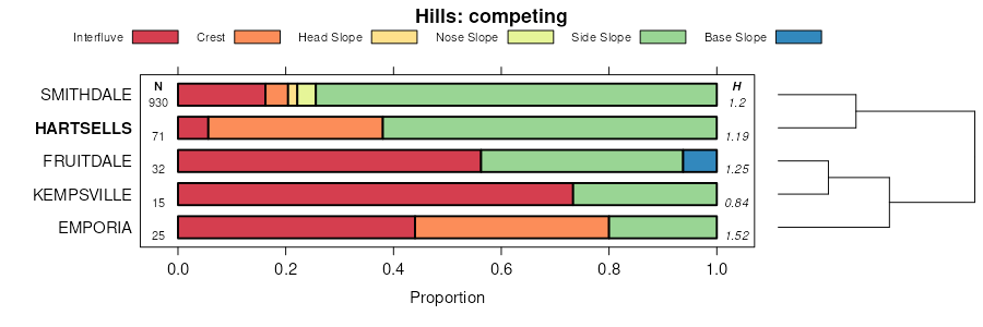
| Hartsells fine sandy loam, 6 to 10 percent slopes, moderately eroded | HeC2 | 34540 | 328373 | 2zpqb | al009 | 1974 | 1:24000 |
Hartsells-Hector complex, 6 to 15 percent slopes | HhD | 26457 | 328374 | 2sr7x | al009 | 1974 | 1:24000 |
Hartsells-Nauvoo complex, 2 to 6 percent slopes, eroded | HnB2 | 12460 | 328372 | 2ykf9 | al009 | 1974 | 1:24000 |
Hartsells-Rock outcrop association, steep | HC | 16489 | 523009 | kk78 | al019 | 1973 | 1:20000 |
Hartsells fine sandy loam, 6 to 10 percent slopes, moderately eroded | HeC2 | 11005 | 523008 | 2zpqb | al019 | 1973 | 1:20000 |
Hartsells-Nauvoo complex, 2 to 6 percent slopes, eroded | HnB2 | 7108 | 523007 | 2ykf9 | al019 | 1973 | 1:20000 |
Hector-Hartsells-Rock outcrop complex, 2 to 10 percent slopes (gorgas-hartsells-rock outcrop) | HdC | 4560 | 523010 | kk79 | al019 | 1973 | 1:20000 |
Hartsells sandy loam, 6 to 10 percent slopes (nauvoo) | HeC | 1792 | 328503 | c0tw | al021 | 1967 | 1:20000 |
Hartsells sandy loam, 2 to 6 percent slopes (nauvoo) | HeB | 1375 | 328502 | c0tv | al021 | 1967 | 1:20000 |
Hartsells fine sandy loam, 6 to 10 percent slopes, moderately eroded | HeC2 | 47340 | 328905 | 2zpqb | al043 | 1960 | 1:20000 |
Hartsells-Gorgas complex, 10 to 15 percent slopes, moderately eroded | HsD2 | 22035 | 328911 | 30v92 | al043 | 1960 | 1:20000 |
Hartsells fine sandy loam, shallow, 10 to 15 percent slopes | HsD | 5142 | 328910 | c180 | al043 | 1960 | 1:20000 |
Hartsells fine sandy loam, shallow, 10 to 15 percent slopes, severely eroded | HsD3 | 2060 | 328912 | c182 | al043 | 1960 | 1:20000 |
Hartsells fine sandy loam, 6 to 10 percent slopes, severely eroded | HrC3 | 1926 | 328907 | c17x | al043 | 1960 | 1:20000 |
Hartsells fine sandy loam, 2 to 6 percent slopes, eroded, shallow | HsB2 | 374 | 328908 | 2wc2g | al043 | 1960 | 1:20000 |
Hartsells fine sandy loam, 6 to 10 percent slopes, moderately eroded | HeC2 | 93000 | 329161 | 2zpqb | al049 | 1953 | 1:20000 |
Hartsells fine sandy loam, 6 to 10 percent slopes, shallow | Hg | 8000 | 329162 | 2wc1w | al049 | 1953 | 1:20000 |
Hartsells-Nauvoo complex, 2 to 6 percent slopes, eroded | HnB2 | 5000 | 329163 | 2ykf9 | al049 | 1953 | 1:20000 |
Hartsells fine sandy loam, 2 to 6 percent slopes, moderately eroded | HrB2 | 2000 | 329160 | 2y740 | al049 | 1953 | 1:20000 |
Hartsells fine sandy loam, undulating, shallow | Hk | 1000 | 329164 | c1j6 | al049 | 1953 | 1:20000 |
Hartsells fine sandy loam, 6 to 15 percent slopes | 28 | 24700 | 329396 | 2wc1v | al055 | 1976 | 1:20000 |
Hartsells-Nauvoo complex, 2 to 6 percent slopes, eroded | HnB2 | 15275 | 329395 | 2ykf9 | al055 | 1976 | 1:20000 |
Hartsells-Rock outcrop complex, 2 to 10 percent slopes | 29 | 6700 | 329397 | c1rq | al055 | 1976 | 1:20000 |
Hartsells-Rock outcrop association, steep | 31 | 4050 | 329400 | c1rt | al055 | 1976 | 1:20000 |
Hartsells-Urban land complex, 2 to 15 percent slopes | 30 | 1140 | 329399 | c1rs | al055 | 1976 | 1:20000 |
Hartsells fine sandy loam, 6 to 10 percent slopes, shallow | Hfg | 23984 | 522897 | 2wc2k | al071 | 1943 | 1:24000 |
Hartsells-Nauvoo complex, 2 to 6 percent slopes, eroded | HnB2 | 12284 | 522896 | 2ykf9 | al071 | 1943 | 1:24000 |
Hartsells fine sandy loam, 2 to 6 percent slopes, shallow | Hfm | 7338 | 522898 | 2wc2h | al071 | 1943 | 1:24000 |
Hartsells fine sandy loam, 6 to 10 percent slopes, moderately eroded | HeC2 | 5689 | 522895 | 2zpqb | al071 | 1943 | 1:24000 |
Hartsells fine sandy loam, 2 to 6 percent slopes, moderately eroded | HrB2 | 519 | 522901 | 2y740 | al071 | 1943 | 1:24000 |
Rough gullied land, Muskingum soil material | RgM | 94 | 522946 | kk57 | al071 | 1943 | 1:24000 |
Hartsells fine sandy loam, 6 to 10 percent slopes, moderately eroded | HeC2 | 708 | 330126 | 2zpqb | al079 | 1950 | 1:20000 |
Hartsells fine sandy loam, 2 to 6 percent slopes, eroded | Hc | 187 | 330125 | 2ykf7 | al079 | 1950 | 1:20000 |
Hartsells fine sandy loam, 6 to 10 percent slopes, shallow | Hh | 1044 | 523141 | 2wc1w | al089 | 1958 | 1:24000 |
Hartsells fine sandy loam, 6 to 10 percent slopes, moderately eroded | HeC2 | 343 | 523142 | 2zpqb | al089 | 1958 | 1:24000 |
Hartsells fine sandy loam, 2 to 6 percent slopes, moderately eroded | HrB2 | 222 | 523138 | 2y740 | al089 | 1958 | 1:24000 |
Hartsells fine sandy loam, 2 to 6 percent slopes, shallow | Hd | 200 | 523137 | 2wc2h | al089 | 1958 | 1:24000 |
Hartsells fine sandy loam, 6 to 10 percent slopes, moderately eroded | HeC2 | 35748 | 330700 | 2zpqb | al095 | 1956 | 1:20000 |
Hartsells fine sandy loam, eroded, strongly sloping, shallow | HbD2 | 5551 | 330704 | c33w | al095 | 1956 | 1:20000 |
Hartsells sandy clay loam, severely eroded, sloping | HcC3 | 555 | 330705 | c33x | al095 | 1956 | 1:20000 |
Hartsells fine sandy loam, 2 to 6 percent slopes, eroded, shallow | HbB2 | 555 | 330702 | 2wc2g | al095 | 1956 | 1:20000 |
Hartsells sandy clay loam, severely eroded, gently sloping, shallow | HdB3 | 222 | 330706 | c33y | al095 | 1956 | 1:20000 |
Hartsells-Nauvoo complex, 2 to 6 percent slopes, eroded | HnB2 | 25 | 3175546 | 2ykf9 | al095 | 1956 | 1:20000 |
Hartsells fine sandy loam, 6 to 10 percent slopes, moderately eroded | HeC2 | 10312 | 331087 | 2zpqb | al103 | 1949 | 1:15840 |
Hartsells fine sandy loam, 6 to 10 percent slopes, shallow | Hi | 609 | 331088 | 2wc1w | al103 | 1949 | 1:15840 |
Hartsells fine sandy loam, 2 to 6 percent slopes, shallow | Hk | 469 | 331090 | 2wc2h | al103 | 1949 | 1:15840 |
Hartsells loam, undulating | Hl | 277 | 331091 | c3jc | al103 | 1949 | 1:15840 |
Sipsey-Nauvoo-Hartsells fine sandy loams, 6 to 15 percent slopes | SgD | 66378 | 1947686 | 2wc0q | al133 | 2012 | 1:24000 |
Wynnville-Hartsells complex, 2 to 6 percent slopes | WhB | 26962 | 1947685 | 2sr83 | al133 | 2012 | 1:24000 |
Hartsells fine sandy loam, 3 to 8 percent slopes | HaC | 1338 | 565557 | lzhs | ar047 | 1967 | 1:20000 |
Hartsells fine sandy loam, 1 to 3 percent slopes | HaB | 928 | 565556 | lzhr | ar047 | 1967 | 1:20000 |
Hartsells-Hector complex, 15 to 35 percent slopes, rocky | HcE | 25652 | 2480316 | 2wc2b | ga619 | 2012 | 1:24000 |
Nauvoo-Hartsells complex, 6 to 10 percent slopes | NhC | 18503 | 2480321 | 2wc1b | ga619 | 2012 | 1:24000 |
Hartsells-Nauvoo complex, 10 to 25 percent slopes | HnE | 11389 | 2507944 | 2q788 | ga619 | 2012 | 1:24000 |
Nauvoo-Hartsells complex, 2 to 6 percent slopes | NhB | 10979 | 2480320 | 2wc1d | ga619 | 2012 | 1:24000 |
Hartsells-Hector complex, 2 to 10 percent slopes | HcC | 10510 | 2480315 | 2wc2c | ga619 | 2012 | 1:24000 |
Hartsells-Hector complex, 6 to 15 percent slopes, rocky | HcD | 7367 | 2567642 | 2wc2d | ga619 | 2012 | 1:24000 |
Hartsells fine sandy loam, 6 to 10 percent slopes, moderately eroded | HaC | 4505 | 531268 | 2zpqb | ga621 | 1975 | 1:20000 |
Hartsells fine sandy loam, 15 to 25 percent slopes | HaE | 2780 | 531270 | 2wc21 | ga621 | 1975 | 1:20000 |
Hartsells-Nauvoo complex, 2 to 6 percent slopes, eroded | HaB | 2485 | 531267 | 2ykf9 | ga621 | 1975 | 1:20000 |
Hartsells fine sandy loam, 10 to 15 percent slopes | HaD | 2280 | 531269 | 2wc20 | ga621 | 1975 | 1:20000 |
Hartsells fine sandy loam, 6 to 12 percent slopes | HaC | 7871 | 552414 | ljtt | ky199 | 1969 | 1:12000 |
Hartsells fine sandy loam, 12 to 20 percent slopes | HaD | 7809 | 552415 | ljtv | ky199 | 1969 | 1:12000 |
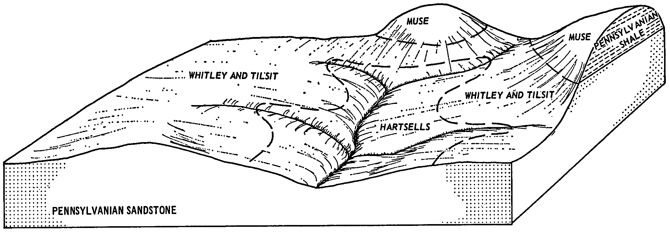
Muse-Hartsells complex, 12 to 20 percent slopes | MtD | 3930 | 552435 | ljvh | ky199 | 1969 | 1:12000 |
Hartsells fine sandy loam, 20 to 30 percent slopes | HaE | 851 | 552416 | ljtw | ky199 | 1969 | 1:12000 |
Hartsells loam, 2 to 6 percent slopes | HrB | 305 | 552417 | ljtx | ky199 | 1969 | 1:12000 |
Hartsells fine sandy loam, gently sloping phase | Hc | 671 | 524913 | km6p | tn031 | 1956 | 1:20000 |
Hartsells fine sandy loam, sloping phase | Hd | 488 | 524914 | km6q | tn031 | 1956 | 1:20000 |
Hartsells fine sandy loam, rolling and undulating phases | Ha | 21226 | 527205 | kplm | tn051 | 1950 | 1:20000 |
Hartsells fine sandy loam, eroded rolling and undulating phases | Hb | 2818 | 527206 | kpln | tn051 | 1950 | 1:20000 |
Hartsells fine sandy loam, 5 to 15 percent slopes | HeC | 990 | 527898 | kq9z | tn123 | 1974 | 1:20000 |
Hartsells loam, 5 to 12 percent slopes | HaC | 6612 | 2427437 | 2mgyf | tn610 | 1960 | 1:15840 |
Hartsells loam, 2 to 5 percent slopes | HaB | 6224 | 2427436 | 2mgyd | tn610 | 1960 | 1:15840 |
Hartsells loam, 5 to 12 percent slopes, eroded | HaC2 | 1427 | 2427438 | 2mgyg | tn610 | 1960 | 1:15840 |


