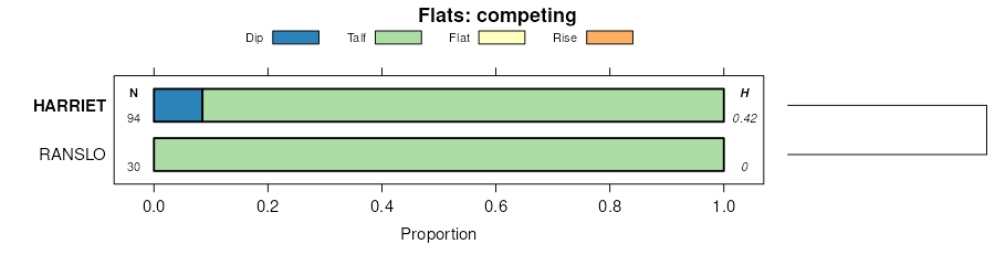
| Harriet loam, 0 to 2 percent slopes, occasionally flooded | E4005A | 19164 | 2525754 | 1vzvm | nd001 | 1983 | 1:20000 |
Korchea, saline-Fluvaquents, channeled-Harriet complex, 0 to 2 percent slopes, frequently flooded | E4184A | 97 | 2755662 | 2qz85 | nd001 | 1983 | 1:20000 |
Harriet loam, 0 to 1 percent slopes, occasionally flooded | F554A | 9 | 2587725 | 2q56r | nd005 | | 1:12000 |
Harriet loam, 0 to 2 percent slopes, occasionally flooded | E4005A | 3985 | 2707103 | 1vzvm | nd007 | 1998 | 1:24000 |
Harriet loam, low precipitation, 0 to 2 percent slopes, occasionally flooded | L4009A | 36 | 2707070 | 2q389 | nd007 | 1998 | 1:24000 |
Korchea, saline-Fluvaquents, channeled-Harriet complex, 0 to 2 percent slopes, frequently flooded | E4184A | 3470 | 2563565 | 2qz85 | nd011 | 1969 | 1:20000 |
Harriet loam, 0 to 2 percent slopes, occasionally flooded | E4005A | 1084 | 2563559 | 1vzvm | nd011 | 1969 | 1:20000 |
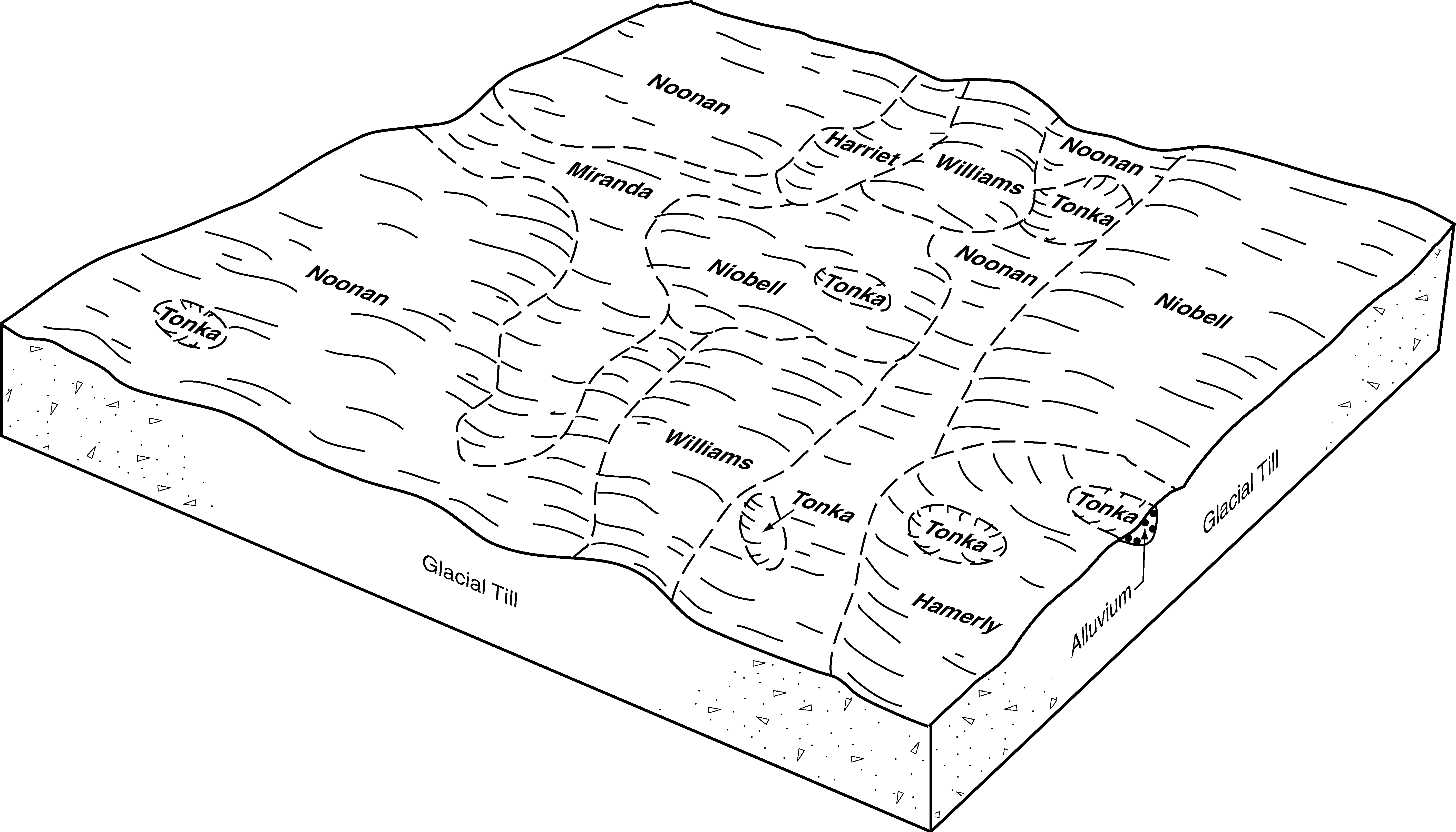
Harriet-Lallie complex, 0 to 2 percent slopes, occasionally flooded | E4007A | 254 | 2563560 | 1vzvn | nd011 | 1969 | 1:20000 |
Harriet loam, low precipitation, 0 to 2 percent slopes, occasionally flooded | L4009A | 72 | 2563493 | 2q389 | nd011 | 1969 | 1:20000 |
Harriet, Regan, and Stirum soils, 0 to 2 percent slopes | 2169 | 20376 | 341110 | cfyk | nd013 | 1991 | 1:24000 |
Harriet-Regan-Stirum complex, 0 to 2 percent slopes, occasionally flooded | C580A | 1515 | 2564080 | 2q2kr | nd013 | 1991 | 1:24000 |
Harriet-Regan-Stirum complex, 0 to 2 percent slopes, occasionally flooded | C580A | 13702 | 2596821 | 2q2kr | nd015 | 1967 | 1:20000 |
Harriet loam, 0 to 2 percent slopes | C584A | 3763 | 2564158 | 2q4w9 | nd015 | 1967 | 1:20000 |
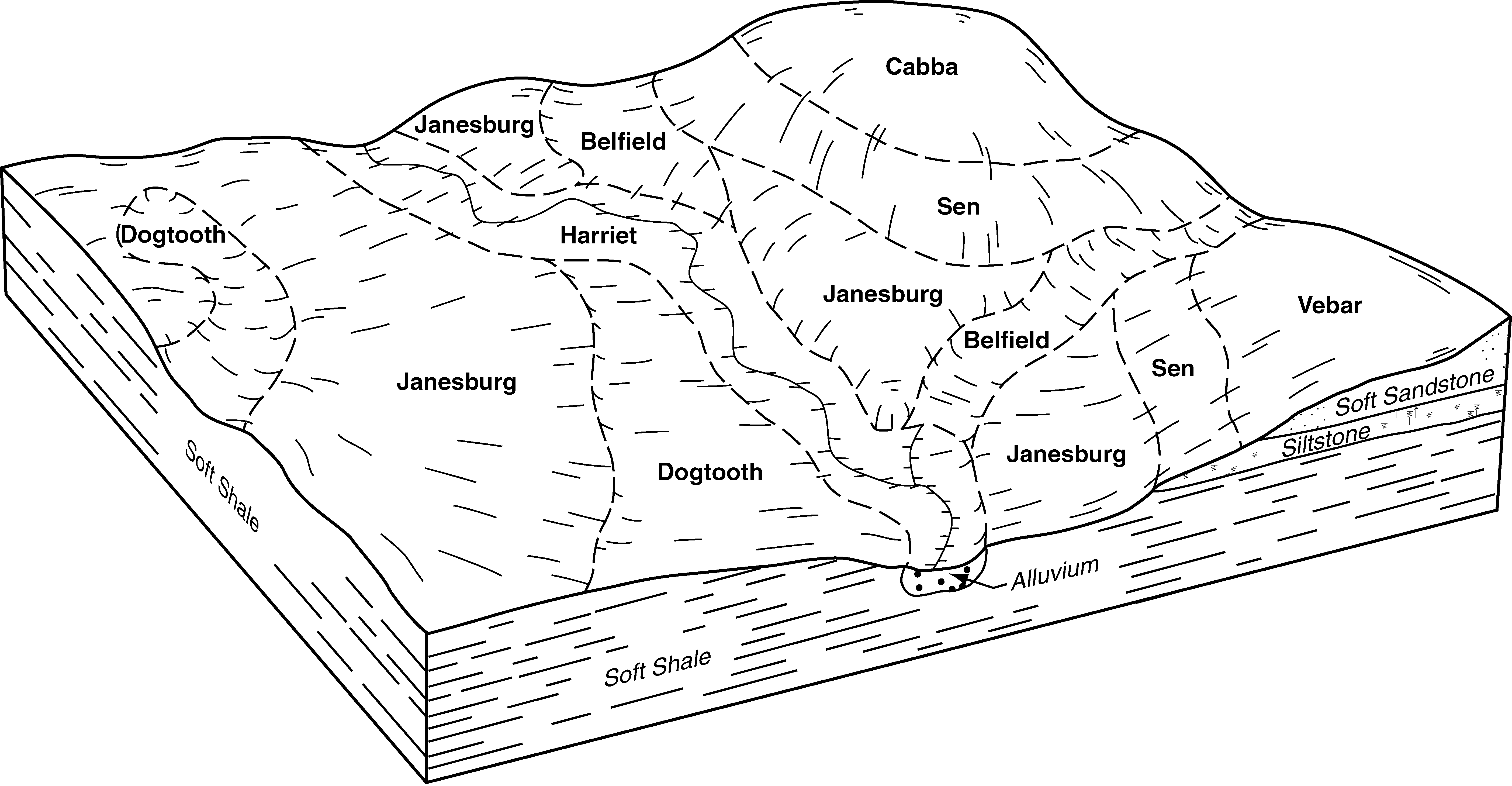
Daglum-Belfield-Harriet occasionally flooded, complex, 0 to 2 percent slopes | C525A | 1248 | 2564174 | 2q6lx | nd015 | 1967 | 1:20000 |
Harriet loam, 0 to 2 percent slopes, occasionally flooded | E4005A | 112 | 2661700 | 1vzvm | nd015 | 1967 | 1:20000 |
Harriet loam, 0 to 1 percent slopes, occasionally flooded | G554A | 1106 | 2575357 | 2q5pm | nd021 | 1989 | 1:20000 |
Harriet loam, 0 to 2 percent slopes | C584A | 65 | 2564226 | 2q4w9 | nd021 | 1989 | 1:20000 |
Harriet, Regan, and Stirum soils, 0 to 2 percent slopes | 2169 | 8665 | 341310 | cg50 | nd023 | 1992 | 1:24000 |
Harriet-Regan-Stirum complex, 0 to 2 percent slopes, occasionally flooded | C580A | 2646 | 2564253 | 2q2kr | nd023 | 1992 | 1:24000 |
Harriet loam, 0 to 2 percent slopes, occasionally flooded | E4005A | 17832 | 2707240 | 1vzvm | nd025 | 1981 | 1:20000 |
Harriet loam, low precipitation, 0 to 2 percent slopes, occasionally flooded | L4009A | 23 | 2707133 | 2q389 | nd025 | 1981 | 1:20000 |
Harriet loam, 0 to 2 percent slopes, occasionally flooded | E4005A | 11274 | 2661786 | 1vzvm | nd029 | 1979 | 1:20000 |
Harriet loam, 0 to 2 percent slopes | C584A | 7403 | 2564327 | 2q4w9 | nd029 | 1979 | 1:20000 |
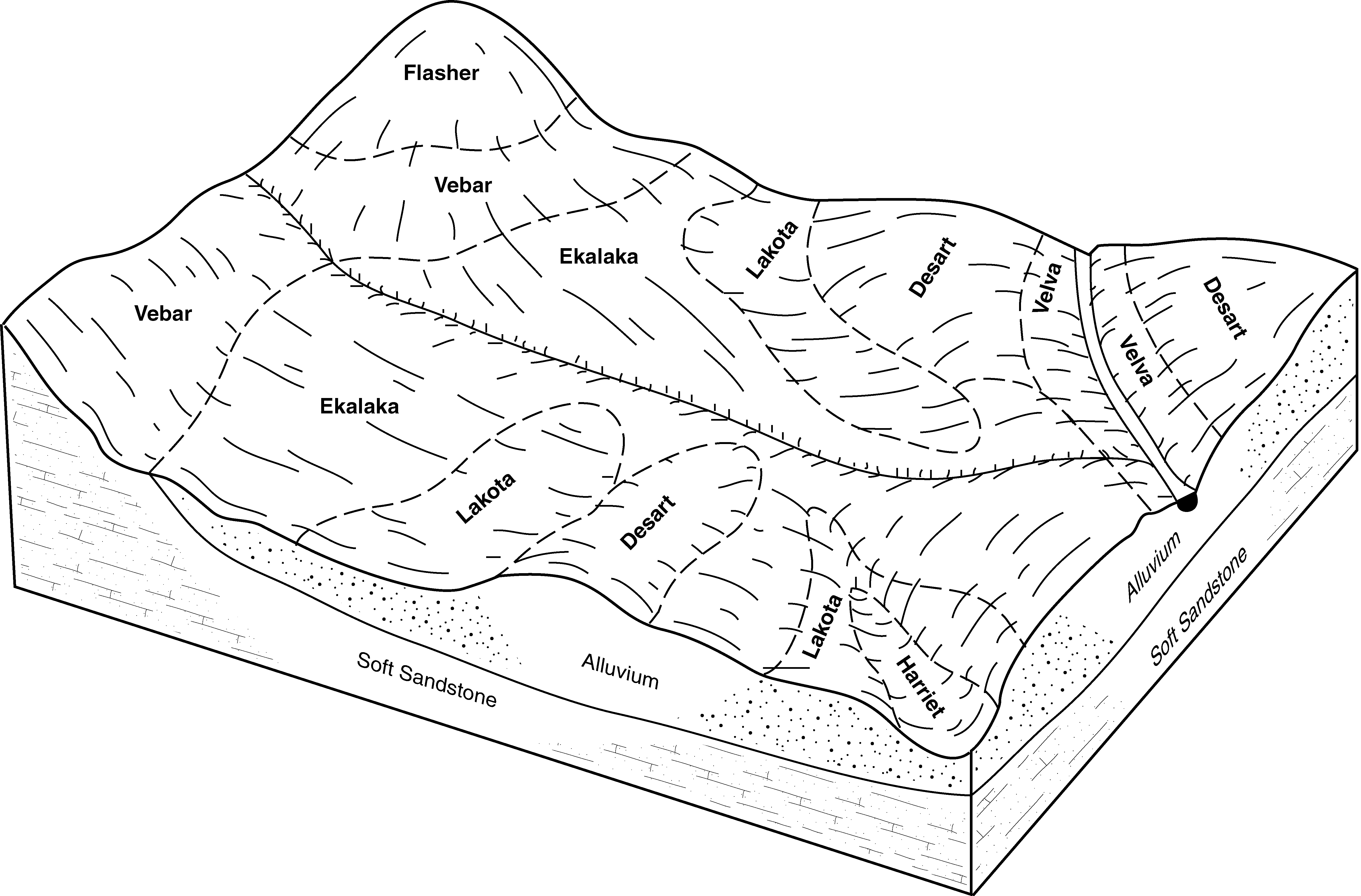
Ranslo-Harriet loams, 0 to 2 percent slopes, occasionally flooded | C578A | 69 | 2595463 | 2qyfq | nd029 | 1979 | 1:20000 |
Harriet-Regan-Stirum complex, 0 to 2 percent slopes, occasionally flooded | C580A | 27 | 2596834 | 2q2kr | nd029 | 1979 | 1:20000 |
Harriet loam, 0 to 2 percent slopes, occasionally flooded | E4005A | 13500 | 2525887 | 1vzvm | nd037 | 1985 | 1:20000 |
Harriet loam, 0 to 2 percent slopes, occasionally flooded | E4005A | 11210 | 2525812 | 1vzvm | nd041 | 1986 | 1:20000 |
Harriet loam, 0 to 2 percent slopes | C584A | 6395 | 2564409 | 2q4w9 | nd043 | 1985 | 1:20000 |
Harriet-Regan-Stirum complex, 0 to 2 percent slopes, occasionally flooded | C580A | 98 | 2596653 | 2q2kr | nd043 | 1985 | 1:20000 |
Harriet loam, 0 to 1 percent slopes, occasionally flooded | G554A | 2376 | 2577103 | 2q5pm | nd045 | 1966 | 1:20000 |
Harriet-Regan-Stirum complex, 0 to 2 percent slopes, occasionally flooded | C580A | 5721 | 2596698 | 2q2kr | nd047 | 1992 | 1:20000 |
Harriet loam, 0 to 2 percent slopes, occasionally flooded | E4005A | 3094 | 2661866 | 1vzvm | nd047 | 1992 | 1:20000 |
Harriet loam, 0 to 1 percent slopes, occasionally flooded | G554A | 7528 | 2571386 | 2q5pm | nd049 | 1987 | 1:20000 |
Harriet loam, 0 to 1 percent slopes, occasionally flooded | F554A | 808 | 2585740 | 2q56r | nd049 | 1987 | 1:20000 |
Harriet loam, 0 to 2 percent slopes | C584A | 6594 | 2566599 | 2q4w9 | nd051 | 1992 | 1:24000 |
Harriet loam, 0 to 2 percent slopes, occasionally flooded | E4005A | 608 | 2662002 | 1vzvm | nd051 | 1992 | 1:24000 |
Harriet-Regan-Stirum complex, 0 to 2 percent slopes, occasionally flooded | C580A | 285 | 2596764 | 2q2kr | nd051 | 1992 | 1:24000 |
Ranslo-Harriet loams, 0 to 2 percent slopes, occasionally flooded | C578A | 119 | 2595534 | 2qyfq | nd051 | 1992 | 1:24000 |
Harriet loam, 0 to 2 percent slopes, occasionally flooded | E4005A | 8865 | 2699333 | 1vzvm | nd053 | 2003 | 1:24000 |
Harriet loam, low precipitation, 0 to 2 percent slopes, occasionally flooded | L4009A | 46 | 2715163 | 2q389 | nd053 | 2003 | 1:24000 |
Harriet-Regan-Stirum complex, 0 to 2 percent slopes, occasionally flooded | C580A | 8657 | 2596868 | 2q2kr | nd055 | 1974 | 1:20000 |
Harriet loam, 0 to 2 percent slopes, occasionally flooded | E4005A | 4503 | 2662461 | 1vzvm | nd055 | 1974 | 1:20000 |
Harriet loam, 0 to 1 percent slopes, occasionally flooded | G554A | 272 | 2577194 | 2q5pm | nd055 | 1974 | 1:20000 |
Harriet loam, 0 to 2 percent slopes, occasionally flooded | E4005A | 2459 | 2699269 | 1vzvm | nd057 | 1976 | 1:20000 |
Harriet loam, 0 to 2 percent slopes, occasionally flooded | E4005A | 12945 | 2699168 | 1vzvm | nd059 | 1998 | 1:20000 |
Harriet loam, 0 to 2 percent slopes, occasionally flooded | E4005A | 5796 | 2662522 | 1vzvm | nd061 | 1988 | 1:24000 |
Harriet loam, 0 to 2 percent slopes | C584A | 5174 | 2566756 | 2q4w9 | nd061 | 1988 | 1:24000 |
Harriet-Regan-Stirum complex, 0 to 2 percent slopes, occasionally flooded | C580A | 220 | 2567087 | 2q2kr | nd061 | 1988 | 1:24000 |
Harriet loam, 0 to 2 percent slopes, occasionally flooded | E4005A | 2734 | 2525986 | 1vzvm | nd065 | 1971 | 1:20000 |
Harriet loam, 0 to 1 percent slopes, occasionally flooded | F554A | 1100 | 2588161 | 2q56r | nd079 | 1990 | 1:24000 |
Harriet loam, 0 to 2 percent slopes | C584A | 2704 | 2566803 | 2q4w9 | nd083 | 1990 | 1:20000 |
Harriet loam, 0 to 1 percent slopes, occasionally flooded | G554A | 1688 | 2581995 | 2q5pm | nd083 | 1990 | 1:20000 |
Harriet-Regan-Stirum complex, 0 to 2 percent slopes, occasionally flooded | C580A | 8 | 2596871 | 2q2kr | nd083 | 1990 | 1:20000 |
Velva-Harriet complex, 0 to 2 percent slopes, occasionally flooded | E4703A | 1772 | 2699137 | d1y5 | nd085 | 1992 | 1:24000 |
Harriet loam, 0 to 2 percent slopes, occasionally flooded | E4005A | 1462 | 2699094 | 1vzvm | nd085 | 1992 | 1:24000 |
Harriet loam, 0 to 2 percent slopes, occasionally flooded | E4005A | 10728 | 2715856 | 1vzvm | nd087 | 1974 | 1:20000 |
Harriet loam, low precipitation, 0 to 2 percent slopes, occasionally flooded | L4009A | 169 | 2715945 | 2q389 | nd087 | 1974 | 1:20000 |
Korchea, saline-Fluvaquents, channeled-Harriet complex, 0 to 2 percent slopes, frequently flooded | E4184A | 23 | 2758522 | 2qz85 | nd087 | 1974 | 1:20000 |
Harriet loam, 0 to 2 percent slopes, occasionally flooded | E4005A | 4573 | 2716000 | 1vzvm | nd089 | 1965 | 1:20000 |
Harriet-Lallie complex, 0 to 2 percent slopes, occasionally flooded | E4007A | 124 | 2716001 | 1vzvn | nd089 | 1965 | 1:20000 |
Harriet loam, strongly saline, 0 to 1 percent slopes, occasionally flooded | F552A | 2002 | 2585121 | 2q56q | nd101 | 1967 | 1:20000 |
Harriet-Regan-Stirum complex, 0 to 2 percent slopes, occasionally flooded | C580A | 1410 | 2596880 | 2q2kr | nd101 | 1967 | 1:20000 |
Harriet loam, 0 to 1 percent slopes, occasionally flooded | F554A | 706 | 2585249 | 2q56r | nd101 | 1967 | 1:20000 |
Harriet and Vallers soils, strongly saline | Hk | 232 | 352505 | ctt4 | nd101 | 1967 | 1:20000 |
Harriet loam, 0 to 2 percent slopes | C584A | 1 | 2566921 | 2q4w9 | nd101 | 1967 | 1:20000 |
Harriet loam, 0 to 1 percent slopes, occasionally flooded | G554A | 1932 | 2579673 | 2q5pm | nd103 | 1966 | 1:12000 |
Harriet-Regan-Stirum complex, 0 to 2 percent slopes, occasionally flooded | C580A | 505 | 2596881 | 2q2kr | nd103 | 1966 | 1:12000 |
Harriet and Stirum soils, 0 to 2 percent slopes | 2270 | 12011 | 339048 | cct1 | nd105 | 1993 | 1:24000 |
Harriet-Regan-Stirum complex, 0 to 2 percent slopes, occasionally flooded | C580A | 2289 | 2596782 | 2q2kr | nd105 | 1993 | 1:24000 |
Harriet loam, 0 to 2 percent slopes, occasionally flooded | E4005A | 1707 | 2662573 | 1vzvm | nd105 | 1993 | 1:24000 |
Ranslo-Harriet loams, 0 to 2 percent slopes, occasionally flooded | G553A | 5975 | 2797792 | 2sd46 | sd013 | 1987 | 1:20000 |
Harriet loam, 0 to 2 percent slopes | C584A | 4579 | 2765575 | 2q4w9 | sd013 | 1987 | 1:20000 |
Harriet loam, 0 to 1 percent slopes, occasionally flooded | G554A | 4030 | 2797690 | 2q5pm | sd013 | 1987 | 1:20000 |
Ranslo-Harriet loams, 0 to 2 percent slopes, occasionally flooded | C578A | 2645 | 2765582 | 2qyfq | sd013 | 1987 | 1:20000 |
Straw-Harriet loams, 0 to 2 percent slopes | C498A | 1617 | 2765594 | 2rrqr | sd013 | 1987 | 1:20000 |
Koto-Harriet loams, 0 to 2 percent slopes | C589A | 1082 | 2765599 | 2rrr1 | sd013 | 1987 | 1:20000 |
La Prairie-Harriet loams, 0 to 2 percent slopes, occasionally flooded | G555A | 383 | 2797793 | 2sd47 | sd013 | 1987 | 1:20000 |
Harriet loam, 0 to 2 percent slopes | C584A | 6129 | 2797895 | 2q4w9 | sd021 | 1978 | 1:20000 |
Ranslo-Harriet loams, 0 to 2 percent slopes, occasionally flooded | C578A | 5137 | 2797907 | 2qyfq | sd021 | 1978 | 1:20000 |
Harriet silt loam | 15 | 828 | 354682 | cx2c | sd021 | 1978 | 1:20000 |
Ranslo-Harriet silt loams | 71 | 204 | 354741 | cx48 | sd021 | 1978 | 1:20000 |
Ranslo-Harriet loams, 0 to 2 percent slopes, occasionally flooded | G553A | 349 | 2798022 | 2sd46 | sd025 | 1992 | 1:20000 |
Harriet loam, 0 to 1 percent slopes, occasionally flooded | G554A | 124 | 2797979 | 2q5pm | sd025 | 1992 | 1:20000 |
Harriet loam, strongly saline, 0 to 1 percent slopes, occasionally flooded | G552A | 53 | 2797978 | 2q5pl | sd025 | 1992 | 1:20000 |
Harriet loam | Hd | 4 | 417735 | g0pb | sd025 | 1992 | 1:20000 |
Harriet loam | Hd | 2928 | 356167 | cym8 | sd031 | 1986 | 1:24000 |
Ranslo-Harriet loams, 0 to 2 percent slopes, occasionally flooded | G553A | 653 | 2798510 | 2sd46 | sd037 | 1992 | 1:20000 |
Harriet loam, 0 to 1 percent slopes, occasionally flooded | G554A | 577 | 2798464 | 2q5pm | sd037 | 1992 | 1:20000 |
Ranslo-Harriet loams, 0 to 2 percent slopes, occasionally flooded | C578A | 11071 | 2798580 | 2qyfq | sd045 | 1973 | 1:20000 |
Ranslo-Harriet loams, 0 to 2 percent slopes, occasionally flooded | C578A | 8749 | 2798647 | 2qyfq | sd049 | 1981 | 1:20000 |
Ranslo-Harriet silt loams | Rh | 3913 | 355193 | cxlv | sd049 | 1981 | 1:20000 |
Harriet silt loam | Ha | 2286 | 355171 | cxl4 | sd049 | 1981 | 1:20000 |
Harriet loam, 0 to 2 percent slopes | C584A | 1927 | 2798641 | 2q4w9 | sd049 | 1981 | 1:20000 |
Ranslo-Harriet loams, 0 to 2 percent slopes, occasionally flooded | C578A | 14164 | 2798746 | 2qyfq | sd089 | 1980 | 1:20000 |
Harriet loam, 0 to 2 percent slopes | C584A | 6309 | 2798731 | 2q4w9 | sd089 | 1980 | 1:20000 |
Ranslo-Harriet loams, 0 to 2 percent slopes, occasionally flooded | G553A | 1521 | 2799250 | 2sd46 | sd089 | 1980 | 1:20000 |
Harriet loam, 0 to 1 percent slopes, occasionally flooded | G554A | 399 | 2798816 | 2q5pm | sd089 | 1980 | 1:20000 |
La Prairie-Harriet loams, 0 to 2 percent slopes, occasionally flooded | G555A | 214 | 2799251 | 2sd47 | sd089 | 1980 | 1:20000 |
Ranslo-Harriet loams, 0 to 2 percent slopes, occasionally flooded | G553A | 8 | 2799355 | 2sd46 | sd091 | 1970 | 1:20000 |
Harriet loam, 0 to 2 percent slopes | C584A | 373 | 2799462 | 2q4w9 | sd107 | 1983 | 1:20000 |
Ranslo-Harriet loams, 0 to 2 percent slopes, occasionally flooded | G553A | 14390 | 2799613 | 2sd46 | sd115 | 1997 | 1:24000 |
Harriet loam, 0 to 1 percent slopes, occasionally flooded | G554A | 3148 | 2799556 | 2q5pm | sd115 | 1997 | 1:24000 |
Harriet loam, 0 to 2 percent slopes | C584A | 995 | 2799500 | 2q4w9 | sd115 | 1997 | 1:24000 |
Ranslo-Harriet loams, 0 to 2 percent slopes, occasionally flooded | C578A | 834 | 2799506 | 2qyfq | sd115 | 1997 | 1:24000 |
Harriet loam, strongly saline, 0 to 1 percent slopes, occasionally flooded | G552A | 36 | 2799555 | 2q5pl | sd115 | 1997 | 1:24000 |
Harriet loam, 0 to 2 percent slopes | C584A | 1200 | 2800103 | 2q4w9 | sd129 | 1975 | 1:20000 |