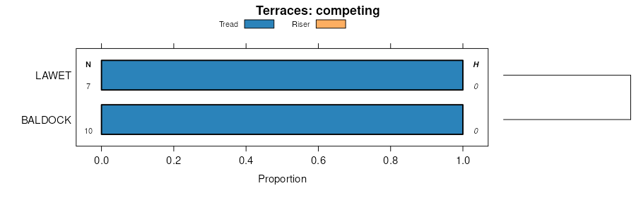
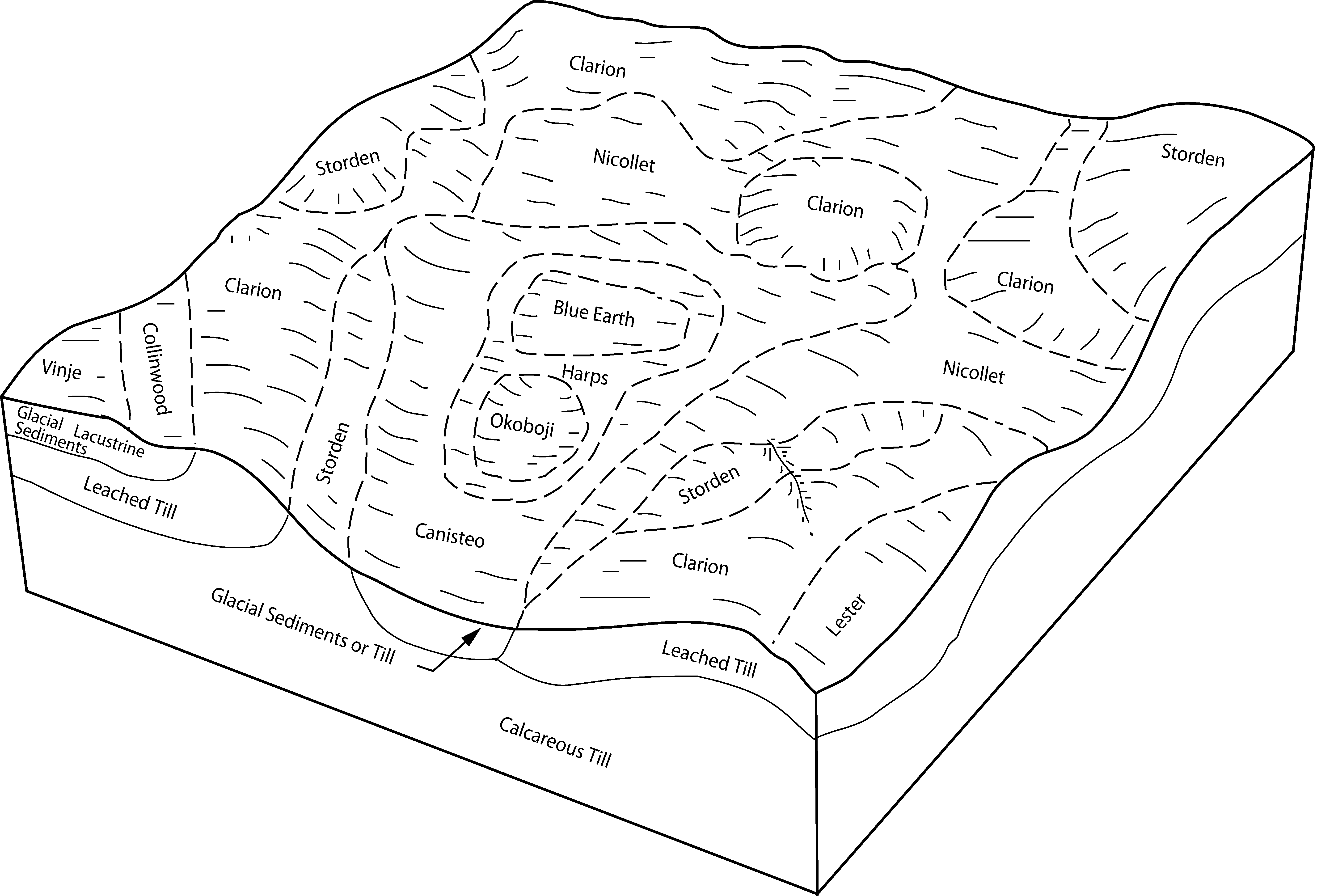
| Harps clay loam, Bemis moraine, 0 to 2 percent slopes | L95 | 9881 | 2835146 | 2tsj8 | ia015 | 1977 | 1:15840 |
Harps clay loam, 0 to 2 percent slopes | 95 | 4179 | 2835160 | 2tsj7 | ia015 | 1977 | 1:15840 |
Harps clay loam, 0 to 2 percent slopes | 95 | 3044 | 403334 | 2tsj7 | ia021 | 1973 | 1:15840 |
Harps clay loam, 0 to 2 percent slopes | 95 | 7688 | 2835170 | 2tsj7 | ia025 | 1979 | 1:15840 |
Harps clay loam, Bemis moraine, 0 to 2 percent slopes | L95 | 92 | 2835147 | 2tsj8 | ia025 | 1979 | 1:15840 |
Harps clay loam, Bemis moraine, 0 to 2 percent slopes | L95 | 2162 | 2835148 | 2tsj8 | ia027 | 1979 | 1:15840 |
Harps clay loam, 0 to 2 percent slopes | 95 | 11036 | 2835171 | 2tsj7 | ia033 | 1978 | 1:15840 |
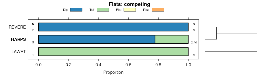
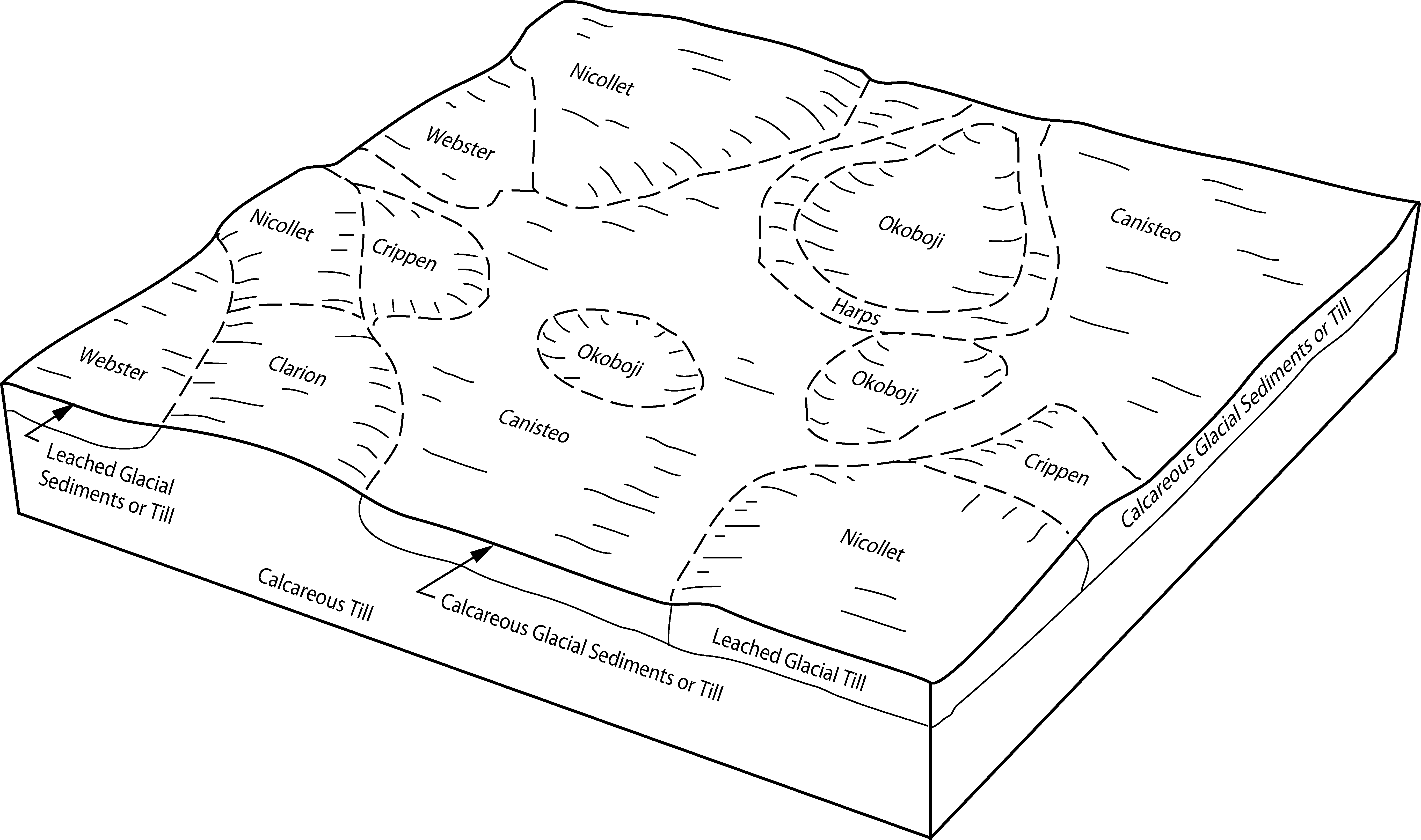
Harps-Okoboji complex, 0 to 2 percent slopes | 956 | 3042 | 403897 | 2tsk2 | ia033 | 1978 | 1:15840 |
Harps clay loam, Bemis moraine, 0 to 2 percent slopes | L95 | 2073 | 2835149 | 2tsj8 | ia033 | 1978 | 1:15840 |
Harps-Okoboji complex, Bemis moraine, 0 to 2 percent slopes | L956 | 658 | 2921876 | 2tsk1 | ia033 | 1978 | 1:15840 |
Harps clay loam, 0 to 2 percent slopes | 95 | 1834 | 399451 | 2tsj7 | ia041 | 2002 | 1:12000 |
Harps clay loam, Bemis moraine, 0 to 2 percent slopes | L95 | 1848 | 2835150 | 2tsj8 | ia049 | 1980 | 1:15840 |
Harps-Okoboji complex, Bemis moraine, 0 to 2 percent slopes | L956 | 1444 | 404639 | 2tsk1 | ia049 | 1980 | 1:15840 |
Harps clay loam, 0 to 2 percent slopes | 95 | 713 | 1869037 | 2tsj7 | ia059 | 2011 | 1:12000 |
Harps clay loam, 0 to 2 percent slopes | 95 | 7074 | 405681 | 2tsj7 | ia063 | 1989 | 1:15840 |
Harps-Okoboji complex, 0 to 2 percent slopes | 956 | 577 | 405682 | 2tsk2 | ia063 | 1989 | 1:15840 |
Harps clay loam, 0 to 2 percent slopes | 95 | 9155 | 2835172 | 2tsj7 | ia069 | 1977 | 1:15840 |
Harps clay loam, Bemis moraine, 0 to 2 percent slopes | L95 | 8297 | 2835151 | 2tsj8 | ia069 | 1977 | 1:15840 |
Harps-Okoboji complex, 0 to 2 percent slopes | 956 | 4008 | 404968 | 2tsk2 | ia069 | 1977 | 1:15840 |
Harps-Okoboji complex, Bemis moraine, 0 to 2 percent slopes | L956 | 3690 | 2921877 | 2tsk1 | ia069 | 1977 | 1:15840 |
Harps clay loam, Bemis moraine, 0 to 2 percent slopes | L95 | 2276 | 2835152 | 2tsj8 | ia073 | 1983 | 1:15840 |
Harps clay loam, 0 to 2 percent slopes | 95 | 1988 | 2835173 | 2tsj7 | ia073 | 1983 | 1:15840 |
Harps clay loam, Bemis moraine, 0 to 2 percent slopes | L95 | 157 | 2835153 | 2tsj8 | ia077 | 1968 | 1:15840 |
Harps clay loam, 0 to 2 percent slopes | 95 | 16747 | 406511 | 2tsj7 | ia079 | 1984 | 1:15840 |
Harps-Okoboji complex, 0 to 2 percent slopes | 956 | 2330 | 406512 | 2tsk2 | ia079 | 1984 | 1:15840 |
Harps clay loam, 0 to 2 percent slopes | 95 | 11774 | 2835174 | 2tsj7 | ia081 | 1987 | 1:15840 |
Harps-Okoboji complex, 0 to 2 percent slopes | 956 | 1567 | 406601 | 2tsk2 | ia081 | 1987 | 1:15840 |
Harps clay loam, Bemis moraine, 0 to 2 percent slopes | L95 | 169 | 2835154 | 2tsj8 | ia081 | 1987 | 1:15840 |
Harps clay loam, Bemis moraine, 0 to 2 percent slopes | L95 | 22204 | 2835155 | 2tsj8 | ia083 | 1982 | 1:15840 |
Harps clay loam, 0 to 2 percent slopes | 95 | 3936 | 2835175 | 2tsj7 | ia083 | 1982 | 1:15840 |
Harps-Okoboji complex, Bemis moraine, 0 to 2 percent slopes | L956 | 3369 | 2921878 | 2tsk1 | ia083 | 1982 | 1:15840 |
Harps-Okoboji complex, 0 to 2 percent slopes | 956 | 793 | 406710 | 2tsk2 | ia083 | 1982 | 1:15840 |
Harps clay loam, 0 to 2 percent slopes | 95 | 6837 | 447472 | 2tsj7 | ia091 | 1998 | 1:12000 |
Harps-Okoboji complex, 0 to 2 percent slopes | 956 | 4870 | 447465 | 2tsk2 | ia091 | 1998 | 1:12000 |
Harps clay loam, 0 to 2 percent slopes | 95 | 40396 | 408410 | 2tsj7 | ia109 | 1980 | 1:15840 |
Harps clay loam, Bemis moraine, 0 to 2 percent slopes | L95 | 288 | 2835156 | 2tsj8 | ia127 | 1978 | 1:15840 |
Harps clay loam, 0 to 2 percent slopes | 95 | 310 | 2499224 | 2tsj7 | ia143 | 1985 | 1:15840 |
Harps clay loam, 0 to 2 percent slopes | 95 | 7297 | 410307 | 2tsj7 | ia147 | 1973 | 1:15840 |
Harps clay loam, 0 to 2 percent slopes | 95 | 8071 | 410420 | 2tsj7 | ia151 | 1982 | 1:15840 |
Harps clay loam, Bemis moraine, 0 to 2 percent slopes | L95 | 1251 | 2835157 | 2tsj8 | ia153 | 1993 | 1:12000 |
Harps-Okoboji complex, Bemis moraine, 0 to 2 percent slopes | L956 | 124 | 412989 | 2tsk1 | ia153 | 1993 | 1:12000 |
Harps clay loam, Bemis moraine, 0 to 2 percent slopes | L95 | 2141 | 2835158 | 2tsj8 | ia161 | 1975 | 1:15840 |
Harps clay loam, 0 to 2 percent slopes | 95 | 352 | 2835177 | 2tsj7 | ia161 | 1975 | 1:15840 |
Harps clay loam, Bemis moraine, 0 to 2 percent slopes | L95 | 12329 | 2835194 | 2tsj8 | ia169 | 1981 | 1:15840 |
Harps clay loam, 0 to 2 percent slopes | 95 | 2278 | 411346 | 2tsj7 | ia169 | 1981 | 1:15840 |
Harps-Okoboji complex, Bemis moraine, 0 to 2 percent slopes | L956 | 1496 | 2921879 | 2tsk1 | ia169 | 1981 | 1:15840 |
Harps-Okoboji complex, 0 to 2 percent slopes | 956 | 1196 | 411347 | 2tsk2 | ia169 | 1981 | 1:15840 |
Harps clay loam, 0 to 2 percent slopes | 95 | 10006 | 797920 | 2tsj7 | ia187 | 2006 | 1:12000 |
Harps-Okoboji complex, 0 to 2 percent slopes | 956 | 1563 | 797967 | 2tsk2 | ia187 | 2006 | 1:12000 |
Harps clay loam, 0 to 2 percent slopes | 95 | 10275 | 412347 | 2tsj7 | ia189 | 1984 | 1:15840 |
Harps-Okoboji complex, 0 to 2 percent slopes | 957 | 2682 | 2511846 | 2tsk2 | ia195 | 2012 | 1:12000 |
Harps clay loam, 0 to 2 percent slopes | 95 | 2230 | 2462493 | 2tsj7 | ia195 | 2012 | 1:12000 |
Harps clay loam, 0 to 2 percent slopes | 95 | 16893 | 2835178 | 2tsj7 | ia197 | 1988 | 1:15840 |
Harps-Okoboji complex, 0 to 2 percent slopes | 956 | 8705 | 412711 | 2tsk2 | ia197 | 1988 | 1:15840 |
Harps clay loam, Bemis moraine, 0 to 2 percent slopes | L95 | 105 | 2835159 | 2tsj8 | ia197 | 1988 | 1:15840 |
Harps clay loam, 0 to 2 percent slopes | 112 | 2731 | 397802 | 2tsj7 | mn047 | 1977 | 1:15840 |
Canisteo-Harps loams | 981 | 35255 | 398738 | fcxj | mn067 | 1983 | 1:20000 |
Harps-Glencoe-Seaforth complex, 0 to 3 percent slopes | 927 | 21797 | 398733 | 2t3p0 | mn067 | 1983 | 1:20000 |
Harps-Okoboji complex, 0 to 2 percent slopes | 899 | 17673 | 398732 | 2tsk2 | mn067 | 1983 | 1:20000 |
Harps clay loam, 0 to 2 percent slopes | 112 | 3032 | 398670 | 2tsj7 | mn067 | 1983 | 1:20000 |
Harps-Glencoe-Seaforth complex, 0 to 3 percent slopes | 1108 | 49051 | 430215 | 2t3p0 | mn073 | 1994 | 1:20000 |
Harps-Glencoe complex | 1092 | 22785 | 399137 | fdbd | mn085 | 1993 | 1:20000 |
Harps clay loam, 0 to 2 percent slopes | 112 | 10591 | 399139 | 2tsj7 | mn085 | 1993 | 1:20000 |
Klossner, sandy substratum-Harps-Mayer complex | 1091 | 1260 | 399136 | fdbc | mn085 | 1993 | 1:20000 |
Harps clay loam, 0 to 2 percent slopes | 112 | 1145 | 400021 | 2tsj7 | mn091 | 1985 | 1:20000 |
Harps-Okoboji complex, 0 to 2 percent slopes | 899 | 6748 | 436450 | 2tsk2 | mn093 | 1996 | 1:20000 |
Harps clay loam, 0 to 2 percent slopes | 112 | 1442 | 436185 | 2tsj7 | mn093 | 1996 | 1:20000 |
Harps clay loam, 0 to 2 percent slopes | 112 | 13839 | 400571 | 2tsj7 | mn103 | 1990 | 1:20000 |
Harps clay loam, 0 to 2 percent slopes | 112 | 29903 | 435999 | 2tsj7 | mn129 | 1995 | 1:20000 |
Harps-Okoboji complex, 0 to 2 percent slopes | 899 | 29265 | 436126 | 2tsk2 | mn129 | 1995 | 1:20000 |
Harps-Glencoe-Seaforth complex, 0 to 3 percent slopes | 927 | 9206 | 436136 | 2t3p0 | mn129 | 1995 | 1:20000 |
Harps clay loam, 0 to 2 percent slopes | 112 | 13877 | 431516 | 2tsj7 | mn143 | 1991 | 1:20000 |
Harps clay loam, 0 to 2 percent slopes | 112 | 504 | 428911 | 2tsj7 | mn165 | 1987 | 1:20000 |
Tetonka-Harps complex | Tt | 9483 | 417998 | g0yt | sd602 | 1975 | 1:20000 |
Crossplain-Harps complex | Ct | 3407 | 417949 | g0x7 | sd602 | 1975 | 1:20000 |