| Runyon-Hapgood association 5 to 30 percent slopes | 296 | 8198 | 487612 | jcdf | ca608 | 2000 | 1:24000 |
Runyon-Hapgood association | 546 | 3911 | 1387152 | 1hkfv | ca685 | 2006 | 1:24000 |
Runyon-Hapgood association | 546sh | 14 | 1899362 | 21rfr | ca703 | 1983 | 1:24000 |
Lamphier-Hapgood families complex, 5 to 20 percent slopes | 25 | 37805 | 510589 | k49m | co676 | 1983 | 1:24000 |
Hapgood-Lamphier families complex, 20 to 50 percent slopes | 21 | 31955 | 510585 | k49h | co676 | 1983 | 1:24000 |
Cochetopa-Adel-Hapgood loams, 5 to 25 percent slopes | 18 | 17025 | 496857 | jp0n | co684 | 1984 | 1:24000 |
Hapgood-Adel-Clayburn loams, 5 to 25 percent slopes | 53 | 14044 | 496896 | jp1x | co684 | 1984 | 1:24000 |
Cochetopa-Adel-Hapgood loams, 25 to 45 percent slopes | 19 | 8845 | 496858 | jp0p | co684 | 1984 | 1:24000 |
Hapgood-Adel-Clayburn loams, 25 to 65 percent slopes | 54 | 7632 | 496897 | jp1y | co684 | 1984 | 1:24000 |
Cochetopa-Gothic-Hapgood loams, 5 to 25 percent slopes | 23 | 6420 | 496863 | jp0v | co684 | 1984 | 1:24000 |
Scout-Dunlatop-Hapgood complex, 25 to 65 percent slopes | 114 | 4753 | 496838 | jp01 | co684 | 1984 | 1:24000 |
Hapgood-Clayburn-Cochetopa loams, 20 to 65 percent slopes | 55 | 4172 | 496898 | jp1z | co684 | 1984 | 1:24000 |
Cochetopa-Gothic-Hapgood loams, 25 to 65 percent slopes | 24 | 2375 | 496864 | jp0w | co684 | 1984 | 1:24000 |
Hapgood-Rhone-Quander loams, 20 to 65 percent slopes | 57 | 2364 | 496900 | jp21 | co684 | 1984 | 1:24000 |
Poose-Hapgood-Emerald loams, 20 to 65 percent slopes | 96 | 1653 | 496943 | jp3f | co684 | 1984 | 1:24000 |
Namela-Adel-Hapgood complex, 5 to 25 percent slopes | 79 | 787 | 496924 | jp2t | co684 | 1984 | 1:24000 |
Hapgood-Dunlatop-Cochetopa loams, 20 to 65 percent slopes | 56 | 509 | 496899 | jp20 | co684 | 1984 | 1:24000 |
Hapgood-Littlemud-Dehana association | 9701 | 2738 | 3270927 | 2z712 | id675 | 1992 | 1:24000 |
Hapgood-Daphsue-Loncan association | 9502 | 176 | 3270923 | 2w2vp | id675 | 1992 | 1:24000 |
Hapgood-Littlemud-Dehana association | 9701 | 22917 | 3270918 | 2z712 | id677 | 1984 | 1:24000 |
Hapgood-Daphsue-Loncan association | 9502 | 551 | 3270914 | 2w2vp | id704 | 1992 | 1:24000 |
Hapgood-Sebud complex, 15 to 45 percent slopes | 4057 | 316 | 150464 | 51kp | id758 | 1998 | 1:24000 |
Sebud-Hapgood-Rock outcrop complex, 25 to 60 percent slopes | 119 | 2433 | 1859652 | 20f3s | mt605 | 2007 | 1:24000 |
Sebud-Hapgood complex, 8 to 45 percent slopes | 118 | 1936 | 1859651 | 20f3r | mt605 | 2007 | 1:24000 |
Hapgood-Sebud very stony loams, 15 to 45 percent slopes | 57 | 445 | 1859632 | 20f34 | mt605 | 2007 | 1:24000 |
Hapgood very stony loam, 4 to 15 percent slopes | 56 | 335 | 1859631 | 20f33 | mt605 | 2007 | 1:24000 |
Libeg-Hapgood complex, 15 to 45 percent slopes | 71 | 190 | 1859637 | 20f39 | mt605 | 2007 | 1:24000 |
Woodhall-Blaine-Hapgood complex, 4 to 25 percent slopes | 157 | 133 | 1859671 | 4xcn | mt605 | 2007 | 1:24000 |
Hapgood loam, moist, 8 to 25 percent slopes | 55 | 70 | 1859630 | 20f32 | mt605 | 2007 | 1:24000 |
Hapgood loam, moist, 2 to 8 percent slopes | 54 | 54 | 1859629 | 20f31 | mt605 | 2007 | 1:24000 |
Sebud-Hapgood complex, 8 to 45 percent slopes | 118 | 12 | 1707980 | 1vb94 | mt623 | 1988 | 1:24000 |
Sebud, very stony-Hapgood complex, 8 to 45 percent slopes | 2111E | 440 | 150850 | 51z4 | mt627 | 1998 | 1:24000 |
Hapgood-Tiban complex, 35 to 70 percent slopes, very stony | 2122F | 353 | 150856 | 51zb | mt627 | 1998 | 1:24000 |
Hapgood-Hanson-Tiban complex, 25 to 60 percent slopes, very stony | 2121F | 323 | 150855 | 51z9 | mt627 | 1998 | 1:24000 |
Hapgood-Sebud-Arrowpeak complex, 35 to 60 percent slopes, very stony | 2123F | 211 | 150858 | 51zd | mt627 | 1998 | 1:24000 |
Sebud-Hapgood family-Rock outcrop complex, 25 to 60 percent slopes | 119 | 1681 | 1702913 | 1v50p | mt635 | 2006 | 1:24000 |
Sebud-Hapgood family, complex, 8 to 45 percent slopes | 118 | 423 | 1702912 | 1v50n | mt635 | 2006 | 1:24000 |
Sebud, very stony-Hapgood family, complex, 8 to 45 percent slopes | 2111E | 104 | 1703092 | 1v56g | mt635 | 2006 | 1:24000 |
Hapgood family-Hanson-Tiban complex, 25 to 60 percent slopes, very stony | 2121F | 92 | 1703094 | 1v56j | mt635 | 2006 | 1:24000 |
Sebud-Hapgood-Rock outcrop complex, 25 to 60 percent slopes | 119 | 60437 | 146391 | 4xb9 | mt636 | 1983 | 1:24000 |
Sebud-Hapgood complex, 8 to 45 percent slopes | 118 | 24244 | 146390 | 4xb8 | mt636 | 1983 | 1:24000 |
Woodhall-Blaine-Hapgood complex, 4 to 25 percent slopes | 157 | 11722 | 146433 | 4xcn | mt636 | 1983 | 1:24000 |
Libeg-Hapgood complex, 15 to 45 percent slopes | 71 | 6600 | 146498 | 4xfr | mt636 | 1983 | 1:24000 |
Hapgood-Sebud very stony loams, 15 to 45 percent slopes | 57 | 2785 | 146482 | 4xf7 | mt636 | 1983 | 1:24000 |
Hapgood very stony loam, 4 to 15 percent slopes | 56 | 2712 | 146481 | 4xf6 | mt636 | 1983 | 1:24000 |
Redchief variant-Hapgood, moist, complex, 8 to 25 percent slopes | 101 | 1115 | 146372 | 4x9p | mt636 | 1983 | 1:24000 |
Hapgood loam, moist, 2 to 8 percent slopes | 54 | 1034 | 146479 | 4xf4 | mt636 | 1983 | 1:24000 |
Hapgood loam, moist, 8 to 25 percent slopes | 55 | 998 | 146480 | 4xf5 | mt636 | 1983 | 1:24000 |
Sebud, very stony-Hapgood complex, 8 to 45 percent slopes | 228 | 147 | 146598 | 4xjz | mt636 | 1983 | 1:24000 |
Tusel-Hapgood association | TV | 7540 | 476181 | hzhp | nv612 | 1968 | 1:24000 |
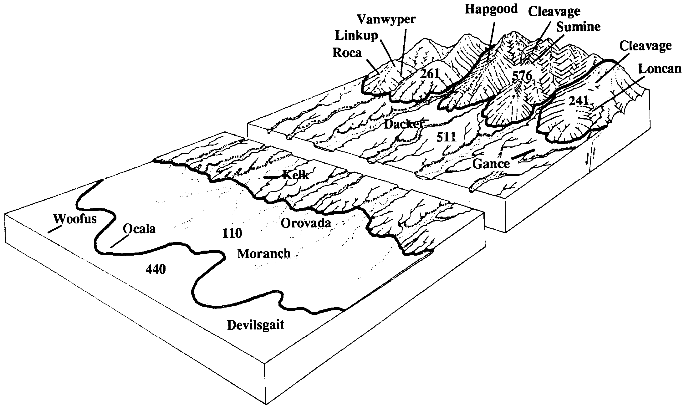
Sumine-Cleavage-Hapgood association | 581 | 5505 | 2519400 | 2rn4l | nv612 | 1968 | 1:24000 |
Hapgood-Packer association | HG | 4682 | 476097 | hzdz | nv612 | 1968 | 1:24000 |
Sumine-Tusel-Hapgood association | 578 | 3280 | 2519971 | 2qjpc | nv612 | 1968 | 1:24000 |
Layview-Westbutte-Hapgood association | 1346 | 9990 | 474573 | hxtt | nv759 | 1995 | 1:24000 |
Devada-Hapgood-Hart Camp association | 1055 | 3910 | 474468 | hxqf | nv759 | 1995 | 1:24000 |
Reywat-Westbutte-Hapgood association | 1327 | 3110 | 474567 | hxtm | nv759 | 1995 | 1:24000 |
Hapgood-Badgercamp-Hackwood association | 1290 | 1980 | 474554 | hxt6 | nv759 | 1995 | 1:24000 |
Hartig-Hapgood association | 1273 | 1870 | 474546 | hxsy | nv759 | 1995 | 1:24000 |
Newlands-Hapgood association | 1257 | 1810 | 474540 | hxsr | nv759 | 1995 | 1:24000 |
Layview-Hapgood association | 1345 | 1710 | 474572 | hxts | nv759 | 1995 | 1:24000 |
Sumine-Cleavage-Hapgood association | 570 | 20264 | 477253 | 2rn4l | nv763 | 1986 | 1:24000 |
Cleavage-Hapgood-Sumine association | 1623 | 15000 | 477079 | j0fn | nv763 | 1986 | 1:24000 |
Sumine-Tusel-Hapgood association, very steep | 578 | 12522 | 477258 | 2qhlk | nv763 | 1986 | 1:24000 |
Bullump-Cleavage-Hapgood association | 922 | 10955 | 477277 | j0n1 | nv763 | 1986 | 1:24000 |
Sumine-Hapgood-Pernty association | 583 | 7501 | 477263 | j0ml | nv763 | 1986 | 1:24000 |
Cleavage-Sumine-Hapgood association | 1622 | 7045 | 477078 | j0fm | nv763 | 1986 | 1:24000 |
Sumine-Chen-Hapgood association | 576 | 6353 | 477256 | hxw4 | nv763 | 1986 | 1:24000 |
Hapgood-Blitzen-Tusel association | 601 | 2625 | 477268 | j0mr | nv763 | 1986 | 1:24000 |
Cleavage-Hapgood-Tweener association | 1617 | 1955 | 477073 | j0fg | nv763 | 1986 | 1:24000 |
Sumine-Tusel-Hapgood association | 577 | 1515 | 477257 | 2q90s | nv763 | 1986 | 1:24000 |
Sumine-Hapgood-Hackwood association | 575 | 1245 | 3270909 | hxw3 | nv763 | 1986 | 1:24000 |
Hapgood-Hackwood-Tusel association | 602 | 605 | 477269 | j0ms | nv763 | 1986 | 1:24000 |
Hackwood-Hapgood-Daphsue association | 1631 | 547 | 3270910 | hxvr | nv763 | 1986 | 1:24000 |
Hapgood-Bullump-Gando association | 600 | 346 | 477267 | j0mq | nv763 | 1986 | 1:24000 |
Hapgood-Daphsue-Loncan association | 9502 | 49718 | 2928291 | 2w2vp | nv764 | 2021 | 1:24000 |
Sumine-Chen-Hapgood association | 576 | 45643 | 474614 | hxw4 | nv764 | 2021 | 1:24000 |
Sumine-Hapgood-Hackwood association | 575 | 42166 | 3270835 | 2zzfw | nv764 | 2021 | 1:24000 |
Inpendence-Hackwood-Hapgood association | 9613 | 20427 | 2454767 | 2ndd1 | nv764 | 2021 | 1:24000 |
Hapgood-Wrenza-Dearbush association | 9615 | 10729 | 2928234 | 2w2ss | nv764 | 2021 | 1:24000 |
Hapgood-Littlemud-Dehana association | 9701 | 7987 | 3263561 | 2z712 | nv764 | 2021 | 1:24000 |
Hapgood-Tusel-Lovamp association | 9417 | 5829 | 474635 | hxwt | nv764 | 2021 | 1:24000 |
Sumine-Tusel-Hapgood association, very steep | 578 | 5257 | 3270836 | 2zzg2 | nv764 | 2021 | 1:24000 |
Hackwood-Hapgood-Daphsue association | 1631 | 4046 | 474602 | hxvr | nv764 | 2021 | 1:24000 |
Cleavage-Bullump-Hapgood association | 236 | 3724 | 474609 | hxvz | nv764 | 2021 | 1:24000 |
Sumine-Pernty-Hapgood association | 584 | 3528 | 474617 | hxw7 | nv764 | 2021 | 1:24000 |
Sumine-Hapgood-Pernty association | 2031 | 3236 | 2517907 | 2qhln | nv764 | 2021 | 1:24000 |
Sumine-Tusel-Hapgood association | 577 | 2613 | 2517707 | 2q90s | nv764 | 2021 | 1:24000 |
Gollaher-Cleavage-Hapgood association | 808 | 25185 | 475137 | hyf0 | nv765 | 1986 | 1:24000 |
Gollaher-Ekim-Hapgood association | 805 | 24180 | 475134 | hydx | nv765 | 1986 | 1:24000 |
Shalcleav-Gollaher-Hapgood association | 223 | 13275 | 474950 | hy6z | nv765 | 1986 | 1:24000 |
Scalfar-Hapgood association | 655 | 9265 | 475070 | hybv | nv765 | 1986 | 1:24000 |
Cleavage-Cleavage extremely gravelly loam-Hapgood association | 751 | 8710 | 475109 | hyd3 | nv765 | 1986 | 1:24000 |
Cleavage-Sumine-Hapgood association | 755 | 8605 | 475113 | 2rn4k | nv765 | 1986 | 1:24000 |
Sumine-Hapgood-Gollaher association | 540 | 2935 | 475050 | hyb6 | nv765 | 1986 | 1:24000 |
Bullump-Sumine-Hapgood association | 550 | 1385 | 475054 | hybb | nv765 | 1986 | 1:24000 |
Xica-Shalcleav-Hapgood association | 700 | 1100 | 475096 | hycp | nv765 | 1986 | 1:24000 |
Hapgood-Daphsue-Loncan association | 9502 | 634 | 3270894 | 2w2vp | nv765 | 1986 | 1:24000 |
Sumine-Tusel-Hapgood association | 1810 | 191 | 478703 | j241 | nv766 | 1994 | 1:24000 |
Sumine-Cleavage-Hapgood association | 570 | 11881 | 478950 | 2rn4l | nv767 | 1986 | 1:24000 |
Hapgood-Daphsue-Loncan association | 9502 | 10722 | 3270904 | 2w2vp | nv767 | 1986 | 1:24000 |
Sumine-Pernty-Hapgood association | 584 | 9092 | 478963 | j2df | nv767 | 1986 | 1:24000 |
Cleavage-Sumine-Hapgood association | 247 | 9004 | 478854 | 2rn4k | nv767 | 1986 | 1:24000 |
Sumine-Tusel-Hapgood association, very steep | 578 | 7617 | 478958 | j2d8 | nv767 | 1986 | 1:24000 |
Loncan-Hapgood-Cleavage association | 862 | 6359 | 479015 | j2g3 | nv767 | 1986 | 1:24000 |
Sumine-Hapgood-Hackwood association | 575 | 6092 | 478955 | j2d5 | nv767 | 1986 | 1:24000 |
Sumine-Chen-Hapgood association | 576 | 6065 | 3270911 | hxw4 | nv767 | 1986 | 1:24000 |
Cleavage-Bullump-Hapgood association | 236 | 5255 | 478844 | j28l | nv767 | 1986 | 1:24000 |
Gollaher-Cleavage-Hapgood association | 030 | 3868 | 478723 | j24p | nv767 | 1986 | 1:24000 |
Sumine-Tusel-Hapgood association, steep | 577 | 2656 | 478957 | j2d7 | nv767 | 1986 | 1:24000 |
Hapgood-Bullump-Gando association | 600 | 2370 | 478969 | j2dm | nv767 | 1986 | 1:24000 |
Hackwood-Hapgood-Cleavage association | 1631 | 2020 | 478761 | j25x | nv767 | 1986 | 1:24000 |
Bregar-Sumine-Hapgood association | 1805 | 1622 | 478776 | j26d | nv767 | 1986 | 1:24000 |
Lerrow-Hapgood-Cleavage association | 722 | 1246 | 478991 | j2fb | nv767 | 1986 | 1:24000 |
Hapgood-Packer-Layview association | 461 | 11857 | 479277 | j2qk | nv768 | 1985 | 1:63360 |
Packer-Hapgood-Torro association | 3094 | 9237 | 479181 | 2whmp | nv768 | 1985 | 1:63360 |
Packer-Layview-Hapgood association | 3093 | 6871 | 479180 | 2whmk | nv768 | 1985 | 1:63360 |
Newlands-Packer-Hapgood association, moderately steep | 3181 | 6702 | 479203 | j2n5 | nv768 | 1985 | 1:63360 |
Halacan-Hapgood-Granzan association | 3342 | 4812 | 479220 | j2nq | nv768 | 1985 | 1:63360 |
Decram-Hapgood association | 3851 | 4638 | 479252 | j2pr | nv768 | 1985 | 1:63360 |
Hapgood-Halacan-Hatur association | 465 | 3803 | 479279 | j2qm | nv768 | 1985 | 1:63360 |
Decram-Hapgood-Chad association | 3852 | 3572 | 479253 | j2ps | nv768 | 1985 | 1:63360 |
Newlands-Packer-Hapgood association, strongly sloping | 3182 | 3352 | 479204 | j2n6 | nv768 | 1985 | 1:63360 |
Packer-Hapgood-Rock outcrop association | 3092 | 2178 | 479179 | j2md | nv768 | 1985 | 1:63360 |
Layview-Packer-Hapgood association | 3881 | 2031 | 479256 | j2pw | nv768 | 1985 | 1:63360 |
Graley-Hapgood-Cleavage association | 8630 | 1927 | 3423191 | 312v0 | nv768 | 1985 | 1:63360 |
Labshaft-Hapgood-Rock outcrop association | 3891 | 1374 | 479257 | j2px | nv768 | 1985 | 1:63360 |
Hackwood-Newlands-Hapgood association | 3101 | 698 | 479183 | j2mj | nv768 | 1985 | 1:63360 |
Hapgood-Packer-Rubble land association | 463 | 650 | 479278 | j2ql | nv768 | 1985 | 1:63360 |
Packer-Layview-Hapgood association | 740 | 21484 | 476660 | 2whmk | nv770 | 1995 | 1:24000 |
Layview-Packer-Hapgood association | 930 | 6615 | 476691 | j014 | nv770 | 1995 | 1:24000 |
Packer-Hapgood-Rock outcrop association | 741 | 118 | 476661 | j005 | nv770 | 1995 | 1:24000 |
Hapgood family, 4 to 15 percent slopes | 502 | 2111 | 476984 | j0bl | nv774 | 1985 | 1:24000 |
Sumine-Hapgood-Cleavage association | 1422 | 8305 | 479464 | j2xl | nv775 | 1985 | 1:24000 |
Hapgood-Tusel-Winada association | 466 | 7545 | 479682 | j34m | nv775 | 1985 | 1:24000 |
Hapgood-Sumine-Cleavage association | 467 | 6390 | 479683 | j34n | nv775 | 1985 | 1:24000 |
Hapgood-Packer-Layview association | 461 | 5330 | 479681 | 2whmw | nv775 | 1985 | 1:24000 |
Layview-Packer-Hapgood association | 3881 | 1035 | 479659 | j33w | nv775 | 1985 | 1:24000 |
Decram-Hapgood association | 551 | 4410 | 479853 | j3b4 | nv776 | 1983 | 1:63360 |
Decram-Hapgood-Loncan association | 552 | 1251 | 479854 | j3b5 | nv776 | 1983 | 1:63360 |
Hapgood-Labshaft-Layview association | 8640 | 65186 | 3423034 | 312v1 | nv782 | 2025 | 1:24000 |
Graley-Hapgood-Cleavage association | 8630 | 15781 | 3423032 | 312v0 | nv782 | 2025 | 1:24000 |
Newlands family-Hapgood family-Mosquet family association | 4004 | 86506 | 3423131 | 31k7q | nv792 | 2025 | 1:24000 |
Erakatak-Ninemile-Hapgood association, 5 to 40 percent slopes | 101 | 6921 | 490461 | jgcb | or628 | 1997 | 1:24000 |
Hapgood very cobbly loam, 2 to 12 percent slopes | 139 | 6235 | 490505 | jgdr | or628 | 1997 | 1:24000 |
Fitzwater-Hapgood association, 20 to 40 percent slopes | 112 | 5103 | 490474 | jgcr | or628 | 1997 | 1:24000 |
Baconcamp-Hapgood-Rock outcrop association, 15 to 50 percent slopes | 34 | 1124 | 490768 | jgp7 | or628 | 1997 | 1:24000 |