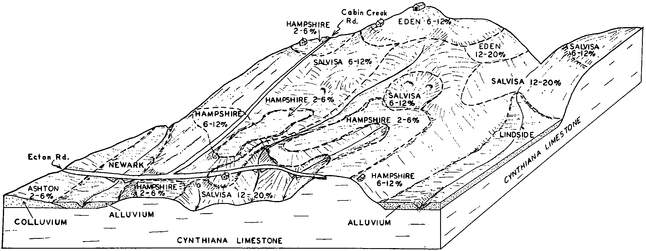
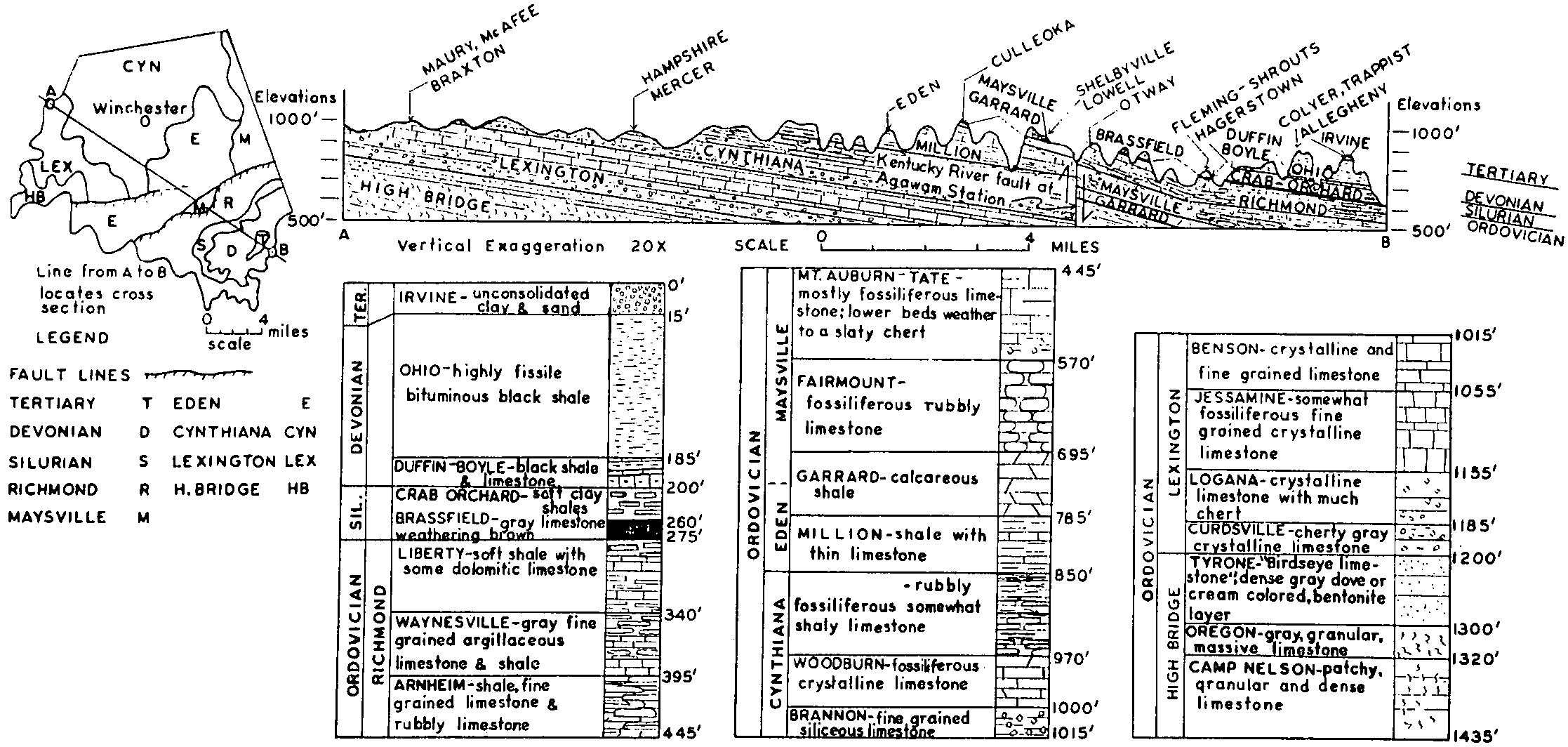
| Hampshire silt loam, 5 to 12 percent slopes, eroded | HaC2 | 140 | 524433 | 2v5bj | tn015 | 1999 | 1:24000 |
Hampshire silt loam, 12 to 20 percent slopes, eroded | HaD2 | 85 | 524434 | 2v63k | tn015 | 1999 | 1:24000 |
Hampshire silt loam, 12 to 20 percent slopes, eroded | HmD | 5021 | 523419 | 2v63k | tn037 | 1977 | 1:15840 |
Hampshire silt loam, 5 to 12 percent slopes, eroded | HmC | 1512 | 523418 | 2v5bj | tn037 | 1977 | 1:15840 |
Hampshire silt loam, 12 to 20 percent slopes, eroded | HhD2 | 1371 | 527067 | 2v63k | tn041 | 1968 | 1:15840 |
Hampshire silt loam, 5 to 12 percent slopes, eroded | HhC2 | 1169 | 527066 | 2v5bj | tn041 | 1968 | 1:15840 |
Hampshire silt loam, 20 to 30 percent slopes, eroded | HhE2 | 457 | 527068 | kpg6 | tn041 | 1968 | 1:15840 |
Hampshire silt loam, 5 to 12 percent slopes, eroded | HaC2 | 428 | 527321 | 2v5bj | tn055 | 1965 | 1:15840 |
Hampshire silt loam, 12 to 20 percent slopes, eroded | HaD2 | 280 | 527322 | 2v63k | tn055 | 1965 | 1:15840 |
Hampshire silty clay loam, 12 to 20 percent slopes, severely eroded | HaD3 | 570 | 527465 | 2v5bl | tn081 | 1997 | 1:24000 |
Hampshire silty clay loam, 5 to 12 percent slopes, severely eroded | HaC3 | 304 | 527464 | 2v5bk | tn081 | 1997 | 1:24000 |
Hampshire-Gullied land complex, 12 to 30 percent slopes | HgD | 98 | 527466 | kpw1 | tn081 | 1997 | 1:24000 |
Hampshire silt loam, 5 to 12 percent slopes, eroded | HaC2 | 60 | 527463 | 2v5bj | tn081 | 1997 | 1:24000 |
Hampshire silt loam, 5 to 12 percent slopes, eroded | HaC2 | 5342 | 525833 | 2v5bj | tn103 | 1999 | 1:24000 |
Hampshire silt loam, 12 to 20 percent slopes, eroded | HaD2 | 2617 | 525834 | 2v63k | tn103 | 1999 | 1:24000 |
Hampshire silt loam, 5 to 12 percent slopes, eroded | HaC2 | 3717 | 524074 | 2v5bj | tn117 | 1999 | 1:24000 |
Hampshire silt loam, 12 to 20 percent slopes, eroded | HaD2 | 2106 | 524076 | 2v63k | tn117 | 1999 | 1:24000 |
Hampshire silty clay loam, 5 to 12 percent slopes, severely eroded | HaC3 | 1738 | 524075 | 2v5bk | tn117 | 1999 | 1:24000 |
Hampshire silty clay loam, 12 to 20 percent slopes, severely eroded | HaD3 | 1174 | 524077 | 2v5bl | tn117 | 1999 | 1:24000 |
Hampshire silt loam, 2 to 5 percent slopes, eroded | HaB2 | 669 | 524073 | 2v5bh | tn117 | 1999 | 1:24000 |
Inman and Hampshire silty clay loams, severely eroded sloping phase | Ic | 3907 | 527802 | kq6w | tn119 | 1955 | 1:20000 |
Hampshire silt loam, 2 to 5 percent slopes, eroded | Hd | 256 | 527788 | 2v5bh | tn119 | 1955 | 1:20000 |
Hampshire silt loam, 5 to 12 percent slopes, eroded | HaC2 | 1290 | 528232 | 2v5bj | tn149 | 1974 | 1:15840 |
Hampshire silt loam, 12 to 20 percent slopes, eroded | HaD2 | 562 | 528233 | 2v63k | tn149 | 1974 | 1:15840 |
Hampshire silty clay loam, 5 to 12 percent slopes, severely eroded | HbC3 | 559 | 528234 | 2v5bk | tn149 | 1974 | 1:15840 |
Hampshire silt loam, 2 to 5 percent slopes, eroded | HaB | 558 | 528231 | 2v5bh | tn149 | 1974 | 1:15840 |
Hampshire silty clay loam, 12 to 20 percent slopes, severely eroded | HbD3 | 348 | 528235 | 2v5bl | tn149 | 1974 | 1:15840 |
Hampshire silt loam, 5 to 12 percent slopes, eroded | HaC2 | 883 | 529817 | 2v5bj | tn159 | 1992 | 1:24000 |
Hampshire silt loam, 12 to 20 percent slopes, eroded | HaD2 | 491 | 529818 | 2v63k | tn159 | 1992 | 1:24000 |
Hampshire silt loam, 12 to 20 percent slopes, eroded | HaD2 | 1744 | 528358 | 2v63k | tn165 | 1993 | 1:20000 |
Hampshire silt loam, 5 to 12 percent slopes, eroded | HaC2 | 734 | 528357 | 2v5bj | tn165 | 1993 | 1:20000 |
Hampshire silt loam, 12 to 20 percent slopes, eroded | HaD2 | 1465 | 530020 | 2v63k | tn169 | 1993 | 1:24000 |
Hampshire silt loam, 5 to 12 percent slopes, eroded | HaC2 | 1129 | 530019 | 2v5bj | tn169 | 1993 | 1:24000 |
Hampshire silt loam, 5 to 12 percent slopes, eroded | HbC2 | 2560 | 523514 | 2v5bj | tn187 | 1961 | 1:15840 |
Hampshire-Colbert silt loams, 5 to 12 percent slopes, eroded | HeC2 | 2322 | 523519 | kkrq | tn187 | 1961 | 1:15840 |
Hampshire silt loam, 2 to 5 percent slopes, eroded | HbB2 | 1383 | 2974474 | 2v5bh | tn187 | 1961 | 1:15840 |
Hampshire-Colbert silty clay loams, 5 to 12 percent slopes, severely eroded | HhC3 | 949 | 523521 | kkrs | tn187 | 1961 | 1:15840 |
Hampshire silty clay loam, 5 to 12 percent slopes, severely eroded | HcC3 | 854 | 523516 | 2v5bk | tn187 | 1961 | 1:15840 |
Hampshire-Colbert silt loams, 2 to 5 percent slopes, eroded | HeB2 | 713 | 523518 | kkrp | tn187 | 1961 | 1:15840 |
Hampshire silt loam, 12 to 20 percent slopes, eroded | HbD2 | 493 | 523515 | 2v63k | tn187 | 1961 | 1:15840 |
Hampshire silty clay loam, 12 to 20 percent slopes, severely eroded | HcD3 | 292 | 523517 | 2v5bl | tn187 | 1961 | 1:15840 |
Hampshire-Colbert silt loams, 12 to 20 percent slopes, eroded | HeD2 | 258 | 523520 | kkrr | tn187 | 1961 | 1:15840 |
Hampshire-Colbert silty clay loams, 12 to 20 percent slopes, severely eroded | HhD3 | 187 | 523522 | kkrt | tn187 | 1961 | 1:15840 |
Hampshire silt loam, 12 to 20 percent slopes, eroded | HaD2 | 11068 | 528461 | 2v63k | tn189 | 1988 | 1:20000 |
Hampshire silt loam, 5 to 12 percent slopes, eroded | HaC2 | 7506 | 528460 | 2v5bj | tn189 | 1988 | 1:20000 |
Hampshire silty clay loam, 12 to 20 percent slopes, severely eroded | HaD3 | 1927 | 528462 | 2v5bl | tn189 | 1988 | 1:20000 |
Hampshire silt loam, 2 to 5 percent slopes, eroded | HaB2 | 681 | 528459 | 2v5bh | tn189 | 1988 | 1:20000 |


