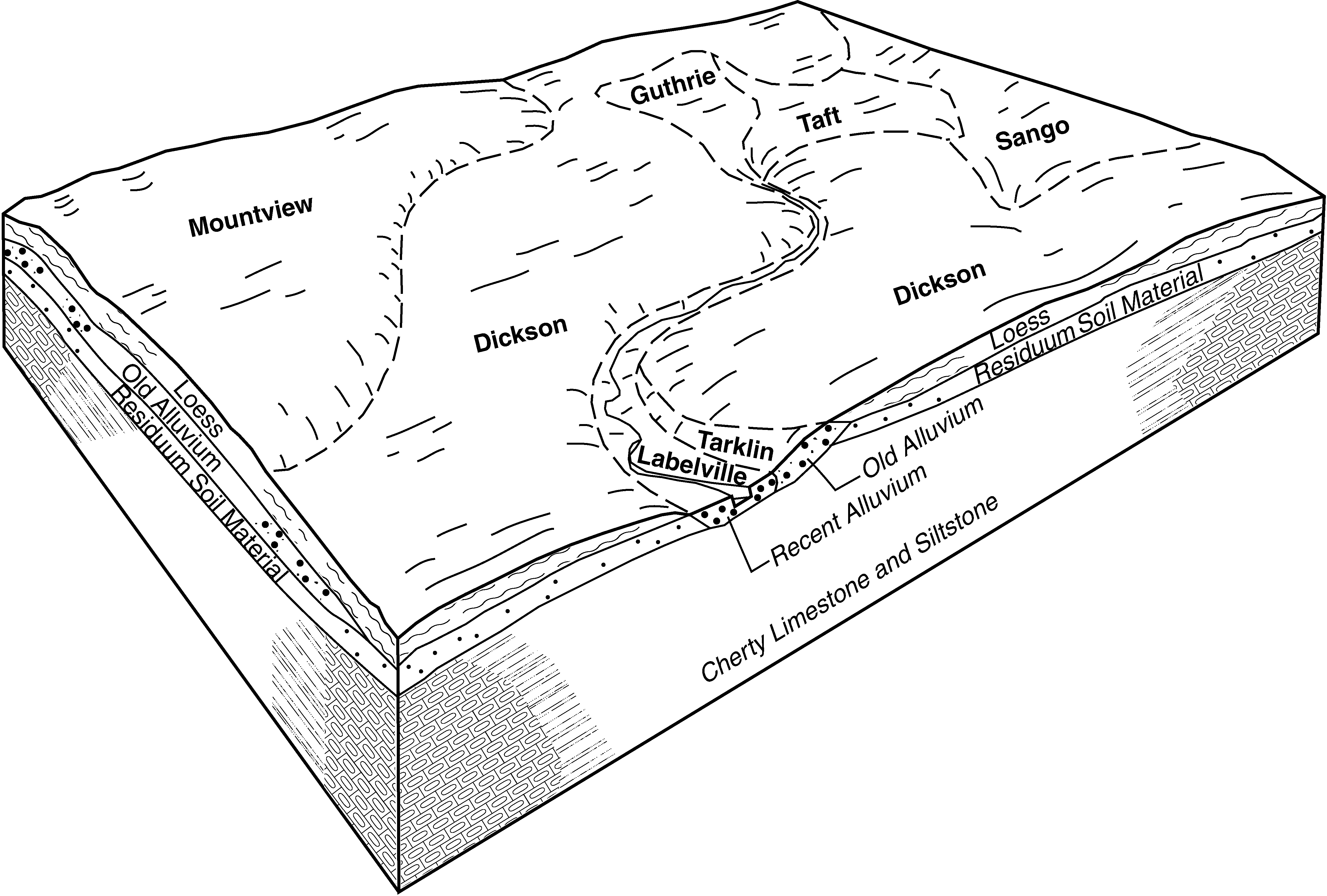
Official Series Description


Lab Data Summary

Aggregate lab data for the GUTHRIE soil series. This aggregation is based on all pedons with a current taxon name of GUTHRIE, and applied along 1-cm thick depth slices. Solid lines are the slice-wise median, bounded on either side by the interval defined by the slice-wise 5th and 95th percentiles. The median is the value that splits the data in half. Five percent of the data are less than the 5th percentile, and five percent of the data are greater than the 95th percentile. Values along the right hand side y-axis describe the proportion of pedon data that contribute to aggregate values at this depth. For example, a value of "90%" at 25cm means that 90% of the pedons correlated to GUTHRIE were used in the calculation. Source: KSSL snapshot . Methods used to assemble the KSSL snapshot used by SoilWeb / SDE

Click the image to view it full size.

Pedons used in the lab summary:

MLRALab IDPedon IDTaxonnameCINSSL / NASIS ReportsLink To SoilWeb GMap
118A68JH091968AR071009Guthrie3Primary | Supplementary | Taxonomy | Pedon | Water Retention | Correlation | Andic Soil Properties35.4514,-93.4778
118A74PO02S1974AR115002Guthrie2Primary | Supplementary | Taxonomy | Pedon | Water Retention | Correlation | Andic Soil Properties35.3017,-93.1474055
12240A49811954TN031019Guthrie3Primary | Supplementary | Taxonomy | Pedon | Water Retention | Correlation | Andic Soil Properties35.416111,-86.098053
n/a40A49821954TN031020Guthrie3Primary | Supplementary | Taxonomy | Pedon | Water Retention | Correlation | Andic Soil Propertiesn/a
n/a98P02581997TN127003Guthrie5Primary | Supplementary | Taxonomy | Pedon | Water Retention | Correlation | Andic Soil Propertiesn/a

Water Balance

Monthly water balance estimated using a leaky-bucket style model for the GUTHRIE soil series. Monthly precipitation (PPT) and potential evapotranspiration (PET) have been estimated from the 50th percentile of gridded values (PRISM 1981-2010) overlapping with the extent of SSURGO map units containing each series as a major component. Monthly PET values were estimated using the method of Thornthwaite (1948). These (and other) climatic parameters are calculated with each SSURGO refresh and provided by the fetchOSD function of the soilDB package. Representative water storage values (“AWC” in the figures) were derived from SSURGO by taking the 50th percentile of profile-total water storage (sum[awc_r * horizon thickness]) for each soil series. Note that this representation of “water storage” is based on the average ability of most plants to extract soil water between 15 bar (“permanent wilting point”) and 1/3 bar (“field capacity”) matric potential. Soil moisture state can be roughly interpreted as “dry” when storage is depleted, “moist” when storage is between 0mm and AWC, and “wet” when there is a surplus. Clearly there are a lot of assumptions baked into this kind of monthly water balance. This is still a work in progress.

Click the image to view it full size.


Click the image to view it full size.

Sibling Summary

Siblings are those soil series that occur together in map units, in this case with the GUTHRIE series. Sketches are arranged according to their subgroup-level taxonomic structure. Source: SSURGO snapshot , parsed OSD records and snapshot of SC database .

Click the image to view it full size.

Select annual climate data summaries for the GUTHRIE series and siblings. Series are sorted according to hierarchical clustering of median values. Source: SSURGO map unit geometry and 1981-2010, 800m PRISM data .

Click the image to view it full size.

Geomorphic description summaries for the GUTHRIE series and siblings. Series are sorted according to hierarchical clustering of proportions and relative hydrologic position within an idealized landform (e.g. top to bottom). Most soil series (SSURGO components) are associated with a hillslope position and one or more landform-specific positions: hills, mountain slopes, terraces, and/or flats. Proportions can be interpreted as an aggregate representation of geomorphic membership. The values printed to the left (number of component records) and right (Shannon entropy) of stacked bars can be used to judge the reliability of trends. Small Shannon entropy values suggest relatively consistent geomorphic association, while larger values suggest lack thereof. Source: SSURGO component records .

Click the image to view it full size.

Click the image to view it full size.

There are insufficient data to create the 3D mountains figure.

Click the image to view it full size.

Click the image to view it full size.

Competing Series

Soil series competing with GUTHRIE share the same family level classification in Soil Taxonomy. Source: parsed OSD records and snapshot of the SC database .

Click the image to view it full size.

Select annual climate data summaries for the GUTHRIE series and competing. Series are sorted according to hierarchical clustering of median values. Source: SSURGO map unit geometry and 1981-2010, 800m PRISM data .

There are insufficient data to create the annual climate figure.

Geomorphic description summaries for the GUTHRIE series and competing. Series are sorted according to hierarchical clustering of proportions and relative hydrologic position within an idealized landform (e.g. top to bottom). Proportions can be interpreted as an aggregate representation of geomorphic membership. Most soil series (SSURGO components) are associated with a hillslope position and one or more landform-specific positions: hills, mountain slopes, terraces, and/or flats. The values printed to the left (number of component records) and right (Shannon entropy) of stacked bars can be used to judge the reliability of trends. Shannon entropy values close to 0 represent soil series with relatively consistent geomorphic association, while values close to 1 suggest lack thereof. Source: SSURGO component records .

There are insufficient data to create the 2D hillslope position figure.

There are insufficient data to create the 3D hills figure.

There are insufficient data to create the 3D mountains figure.

There are insufficient data to create the 3D terrace figure.

There are insufficient data to create the 3D flats position figure.

Soil series sharing subgroup-level classification with GUTHRIE, arranged according to family differentiae. Hovering over a series name will print full classification and a small sketch from the OSD. Source: snapshot of SC database .

Block Diagrams

Click a link below to display the diagram. Note that these diagrams may be from multiple survey areas.

  1. KY-2012-01-26-04 | Adair County - April 1964

    Diagram of the Sango-Mountview-Lawrence association in the uplands (Soil Survey of Adair County (Soil Survey of Adair County, Kentucky; April 1964).

  2. KY-2012-01-26-06 | Adair County - April 1964

    Geological cross section of Adair County showing the relationship of the soils to the underlying rocks (Soil Survey of Adair County (Soil Survey of Adair County, Kentucky; April 1964).

  3. KY-2012-01-26-20 | Bath County - September 1963

    Typical landscape showing the topography and the relative position of the principal soils in association 6 and the parent rocks from which the soils formed (Soil Survey of Bath County, Kentucky; September 1963).

  4. TN-2010-11-02-01 | Cannon County - 2003

    Typical pattern of soils and parent material in the Dickson-Mountview general soil map unit (Soil Survey of Cannon County, Tennessee; 2003).

  5. TN-2010-11-02-17 | Lewis County - 2006

    Typical pattern of soils and parent material in the Dickson-Ironcity-Taft general soil map unit (Soil Survey of Lewis County, Tennessee; 2006).

  6. TN-2010-11-02-23 | Moore County - 2006

    Typical pattern of soils and parent material in the Mountview-Dickson-Taft general soil map unit (Soil Survey of Moore County, Tennessee; 2006).

  7. TN-2012-03-19-30 | Warren County - September 1967

    Major and minor soils and underlying parent material in the Dickson-Mountview association (Soil Survey of Warren County, TN; 1967).

Map Units

Map units containing GUTHRIE as a major component. Limited to 250 records.

Map Unit Name Symbol Map Unit Area (ac) Map Unit Key National Map Unit Symbol Soil Survey Area Publication Date Map Scale
Guthrie silt loamGb589523006kk75al01919731:20000
Guthrie silt loam, 0 to 2 percent slopes, frequently floodedGuA30703287022s8m7al03319861:20000
Guthrie silt loamGl544522892kk3hal07119431:24000
Guthrie silt loam, 0 to 2 percent slopes, frequently floodedGu65015230502s8m7al07719731:20000
Guthrie silt loam, 0 to 2 percent slopes, occasionally floodedGl209575227792sr88al08319531:20000
Guthrie silt loam, 0 to 2 percent slopes, rarely floodedGu113705231332s8m8al08919581:24000
Guthrie silt loam, 0 to 2 percent slopes, rarely floodedGa5363310762s8m8al10319491:15840
Guthrie silt loamGu1093523240kkgqal12119691:20000
Guthrie silt loam, 0 to 1 percent slopes, occasionally flooded11126430860322t5yxar02319831:20000
Guthrie silt loam, 0 to 2 percent slopes, occasionally flooded1272915653782t5yyar02919771:20000
Guthrie silt loam, 0 to 1 percent slopes, occasionally floodedGu17345655502t5yxar04719671:20000
Guthrie silt loam, 0 to 1 percent slopes, rarely floodedGt16775655492t5ywar04719671:20000
Guthrie silt loam, 0 to 1 percent slopes, rarely floodedGe27685658312t5ywar07119731:24000
Guthrie silt loam, 0 to 1 percent slopes, rarely flooded1522845658782t5ywar08319771:20000
Guthrie silt loam, 0 to 2 percent slopes, occasionally flooded15129205660862t5yyar10519801:20000
Guthrie silt loam, 0 to 1 percent slopes, rarely flooded1240615661162t5ywar11519781:20000
Guthrie-Leadvale complex, 0 to 3 percent slopesGeB158855661762vz87ar11919721:20000
Guthrie silt loam, 0 to 1 percent slopes, occasionally flooded1122130861792t5yxar14119831:20000
Guthrie silt loam, 0 to 1 percent slopes, rarely flooded1359825666392t5ywar14519801:20000
Guthrie silt loam, 0 to 1 percent slopes, occasionally flooded24231065649822t5yxar14919851:20000
Guthrie silt loam, 0 to 1 percent slopes, rarely flooded23102295649812t5ywar14919851:20000
Guthrie silt loam, ponded, 0 to 2 percent slopesGuA229316103841r1qwga01520131:12000
Guthrie silt loam, 0 to 2 percent slopesGuA24025676482q79kga61920121:24000
Guthrie variant soilsGU1880531263kttjga62119751:20000
Guthrie silt loam, 0 to 2 percent slopes, occasionally floodedGrA990562931lws2ga64820011:12000
Guthrie silt loam, 0 to 2 percent slopes, frequently pondedGw19685244312v5c3tn01519991:24000
Guthrie silt loam, 0 to 2 percent slopes, occasionally pondedGu5195270122v5c5tn02119911:24000
Guthrie silt loamGs68524520klt0tn02519481:24000
Guthrie silt loam, 0 to 2 percent slopes, occasionally pondedGe94635249092v5c5tn03119561:20000
Robertsville silt loamRa720524977km8rtn03119561:20000
Robertsville silt loam, overwash phaseRb125524978km8stn03119561:20000
Guthrie silt loam, overwash phaseGf81524910km6ltn03119561:20000
Guthrie silt loam, 0 to 2 percent slopes, occasionally pondedGu24345270652v5c5tn04119681:15840
Guthrie silt loam, 0 to 2 percent slopes, frequently pondedGu7875271052v5c3tn04319931:24000
Guthrie silt loamGd3556527204kplltn05119501:20000
Guthrie silt loamGw443527320kpqbtn05519651:15840
Guthrie silt loamGu546101786013556tn06519801:15840
Guthrie silt loam, 0 to 2 percent slopes, occasionally pondedGu1085274622v5c5tn08119971:24000
Guthrie silt loam, 0 to 2 percent slopes, frequently pondedGl655275682v5c3tn08519431:20000
Guthrie silt loamGc6568527646kq1vtn09919551:20000
Guthrie silt loam, overwash phaseGd2816527647kq1wtn09919551:20000
Guthrie silt loam, 0 to 2 percent slopes, frequently pondedGu3485308632v5c3tn10119991:24000
Guthrie silt loam, 0 to 2 percent slopes, frequently pondedGu112855258322s8m9tn10319991:24000
Guthrie silt loam, 0 to 2 percent slopes, occasionally pondedGu8955277012v5c5tn11119921:24000
Robertsville silt loam (Guthrie)Ra419526296knn9tn11519511:20000
Guthrie silt loam, 0 to 2 percent slopes, occasionally pondedGu44815279842v5c5tn12519721:15840
Guthrie silt loam, 0 to 2 percent slopes, frequently pondedGu8236257422v5c3tn12720021:24000
Guthrie silt loam, 0 to 2 percent slopes, frequently pondedGu52485281722v5c3tn14719651:15840
Guthrie silt loam, 0 to 2 percent slopes, frequently pondedGf125923969112v5c3tn16119531:20000
Guthrie silt loam, 0 to 2 percent slopes, frequently pondedGu27025283562v5c3tn16519931:20000
Guthrie silt loam, 0 to 2 percent slopes, occasionally pondedGu52545298892v5c5tn17719651:15840
Guthrie silt loam, 0 to 2 percent slopes, frequently pondedGu4263280132s8m9tn18119961:24000
Guthrie silt loamGu698528561kr0ctn60219731:15840
Guthrie silt loam, 0 to 2 percent slopes, occasionally pondedGu21985286532v5c5tn60419741:20000
Guthrie silt loam, 0 to 2 percent slopes, frequently pondedGs100924274352v5c3tn61019601:15840
Guthrie silt loam, 0 to 2 percent slopes, frequently pondedGu32624391712v5c3tn70119851:24000

Map of Series Extent

Approximate geographic distribution of the GUTHRIE soil series. To learn more about how this distribution was mapped, or to compare this soil series extent to others, use the Series Extent Explorer (SEE) application. Source: generalization of SSURGO geometry .